2c to 4a Commercial Street
1860s shops with offices over, built for T. Venables & Sons, draper and furnisher
Before Commercial Street: Essex Street and Catherine Wheel Alley up to the 1830s
Contributed by Survey of London on Dec. 12, 2018
Commercial Street roughly follows the line of Catherine Wheel Alley which ran between Whitechapel High Street and Wentworth Street. Catherine (sometime ‘Katherine’ before the eighteenth century) Wheel Alley took its name from the Catherine Wheel Inn on or near Wentworth Street, and formed a boundary between two landholdings which had probably formed parts of the Trentemars estate from the thirteenth century: the Woodlands estate to the west, held by William Meggs from the 1570s, and a part of the Bernes estate to the east, held by various members of the Cornwalyes or Cornwallis family in the fifteenth century, but fragmented by the sixteenth.[1^] Catherine Wheel Alley was built up in the later sixteenth century. A number of substantial houses were there by the mid seventeenth century, especially on either side of the central portion.
A large part of the east side of the alley, including property in Wentworth Street, was held in the seventeenth and eighteenth centuries by members of the Garrad family, beginning with Sir Jacob Garrad (c. 1586−1666), the son of Thomas Garrad, saddler and Sheriff of the City of London (d. 1632), and created baronet of Langford in 1662. Sir Jacob, also a City alderman, amassed a fortune as a linen draper and East India Company adventurer, importing calicoes from India in the 1640s and 50s. As well as his Whitechapel property, he left substantial property in London, Essex, Suffolk, Norfolk and notably Ireland, a result of investments in the repression of the Irish rebellions of 1641−2, which yielded land for loans.2 The Whitechapel properties passed through his son Thomas (who adopted the spelling Garrard), second baronet, and great-granddaughter Sarah Downing to her son Sir Jacob Garrard Downing (c.1717−64), who disposed of them in the 1750s.3
The long plots running east and west from the central portion of the alley were occupied in the seventeenth and early eighteenth centuries principally by those involved in the silk trades – weavers and, especially, throwers. Some plots included substantial houses, such that of John Fromanteel (c.1586−1665), previously in the Minories, and his son Mordecai (1642-98), and his heirs, held of the Garrads on the east side (the southern half of the site of Toynbee Hall) from 1656 to 1707.4 With eight hearths in the 1660s and 70s it was almost certainly the large, supposedly Elizabethan, house (reputedly a residence of the Earl of Essex) described just before its demolition for the creation of Commercial Street in 1844, as ‘at the rear of the houses forming that street. It is three stories high. The attic windows are latticed, and the rooms on the first and second floors are 14 feet square. There is a part of the spacious staircase remaining, and the joists and girders are in as good preservation as when originally placed in the brickwork’.5 By the time of John Fromanteel’s death in 1665 the site contained this large house, with warehouse and garden, another smaller house adjoining fronting Catherine Wheel Alley, in the occupation of his daughter Mary and her silk-thrower husband, John Lakins, and two smaller houses, probably those to the north evident on Ogilby and Morgan’s map of 1676. At the time that Mordecai Fromanteel’s nephew John leased the house to Roger Smith in 1701, the house boasted twelve rooms including a Great Room ‘wainscoted all over’ with paintings above the chimney piece and doors, a Great Parlour and Drawing Room similarly fitted, a ‘Blew Room’, ‘hung with blew (fabric)’, the ‘staires case lined brest high from the top to the bottome’, a summer house, two warehouses, a counting house, a shop, a back yard with chicken coops and horse pond, and a garden with four stone pedestals, a sundial and a fountain.6
The Fromanteels’ house was unusual both in its size and in surviving till the 1840s. While other large buildings appear on the west side of the 1676 map, hearth tax returns suggest most of these were largely commercial rather than domestic, most likely sheds for silk-throwers who, until mechanisation of the trade, required long spaces for their work. The accompanying houses were less grand than Fromanteel’s, many with only three or four hearths in the 1660s and 1670s.
Mechanisation and the shift to larger throwing enterprises outside London from the early eighteenth century both hit the small throwers in Whitechapel and Spitalfields and reduced the need for large spaces. It thereby led to the development of these sites as alleys and courts of small houses.7 The first to be so developed was Sugar Loaf Alley or Court, on the east side near the High Street, already a long narrow court of fourteen houses by the 1670s. In the early eighteenth century these were held by Richard Arters ‘clothworker and Citizen of London’ (d. 1736). In 1719 and 1730 he was also advertising plots of land on the west side with an 80ft frontage to the alley and more than 100ft deep, each to be let on building leases, ‘whereon are now some old tenements and other buildings’. These were developed as Martin Street, and New Martin Street, connected courts of small houses of two and three rooms, known later all as Martin or Martin’s Court.8
By the mid eighteenth century, there were four courts or alleys on the west side – from south to north: Rose and Crown Court, present by the late seventeenth century and historically an extension of Nag’s Head Yard, Martin’s Court and Moor’s Court. On the east side, from the north, were George’s Buildings, later Griggs Court, Catherine Wheel Court (a small square of fourteen houses entered from the southwest corner), and Sugar Loaf Alley.9
Though it lacked the presence and exposure offered by the High Street, Catherine Wheel Alley, as a much-used cut-through to Spitalfields, developed a character of a secondary shopping street, with the usual small grocers and bakers, and a number of long-standing hostelries, mostly on the west side. One of the earliest was Bland’s Coffee House, documented between 1695 and 1730.10
The Catherine Wheel itself originally seems to have stood near the north end, though by the time of its demolition, when the licensee was Christian Sohnge, furrier, it was at the south end of the west side.11 A few doors to the north, flanking the entrance to the extensive Rose and Crown Court, was the Rose and Crown, present by 1730.12 By the time of its sale for the building of Commercial Street, it was owned by James and Charles Goding of the Lion Brewery in Lambeth.13
The Throwster’s Arms was at the corner of Martin Street, in the middle of the west side by 1787 and remained till demolition for Commercial Street.14 During the tenure of the licensee Edward Dyke (d. 1835) and his widow, Jane, the pub was used regularly for inquests and, appropriately perhaps, in 1833 the Friendly Burial Society was founded there.15
In the second half of the eighteenth century the area around Catherine Wheel Alley grew ever denser, both with housing and industry. Essex Court, north of Moor’s Court was created on the west side, and, adjoining Catherine Wheel Court on its east side, the optimistically titled Land of Promise.16 The name Essex Street began to be used for Catherine Wheel Alley from the 1790s, exclusively so by c.1805, and by 1820 most of its west side was held freehold or on lease granted by James Livermore (d. 1801), a Tottenham Court Road draper, and his heirs, and by John Elger (1757−1821), who had built Elger Square and Elger Place, near the north end of the Street.17
The final developments in Catherine Wheel Alley were Chapel Court and Cobley’s Court, two at the north end of the east side reached by narrow adjoining alleys. Chapel Court possibly records the presence from c.1718 in Catherine Wheel Alley of a meeting house used by General Baptists previously part of a congregation in Dunning’s Alley, Bishopsgate, though it was out of use by 1729.18 Cobley’s Court, eleven mean houses adjoining it to the south, was created in the 1830s by Thomas Cobley, carman, leaseholder of Fromanteel’s house at the time of its demolition, possibly in anticipation of compensation that might be forthcoming from the Commissioners for the new street.19
As more housing was built, the remaining pockets of unbuilt land and some of the most egregious housing were replaced by industry and commerce. The Land of Promise was rebuilt in 1786-7 as a warehouse, wine vaults and yard by William Quarrill (1721-98), a JP and colourman with premises at 37 Whitechapel High Street, who had leased the adjoining plot to the north, south of Fromanteel’s house, in 1776. 20
Along with one or two other properties at the south end of Essex Street, Quarrill’s yard survived the creation of Commercial Street becoming by 1844 the John Bull brewery yard, the brewery, in Quarrill’s wine vaults at the rear of the yard, run until the 1870s by Frederick and George Bye, with bacon stoves elsewhere in the yard.21 The brewery yard was finally demolished c.1899 for the building of Commercial Street schools.
Fromanteel’s house and yard had been taken by Benjamin and John Titford, dealers in hay, chips and sawdust, by 1802, succeeded in a similar line by William Turner (d. 1830), the premises leased after his death by Thomas Cobley, carman, until demolition in 1844.22
Catherine Wheel Alley and its courts became a byword for overcrowding, crime and general squalor during the century before Commercial Street swept it away. To take just three examples, a trial in the winter of 1792, of a lodging-house keeper accused of dragging a critically ill lodger (‘John Dollin, a black man’) into the street where he died, gives a flavour, with the deceased sharing the room with four other men and women, including a ‘girl of the town’.23 In 1829 three houses in Sugarloaf Court were condemned and sold off for their materials.24 In 1832 and 1833 two separate bands of coiners in courts of Essex Street were convicted for making counterfeit sixpences and shillings.25
By the early nineteenth century other markers of poverty were evident. William Waldegrave, MP for Bedford, who had campaigned among the poor of the East End to attend school reported on a visit to one house in a court off Essex Street where he found nine people ‘generally very dirty’ and ‘in a miserable condition’ occupying one small room, and reckoned that around 360 people lived in the court of thirty houses. The reluctance of the parents, a high proportion of whom were Irish, to send children to school he found was due to lack of clothing and that ‘the priests have such an effect upon their minds’ that they were reluctant to send children to Protestant schools.26 There were frequent outbreaks of disease in the crowded conditions, including typhus in 1817.27
-
‘Stepney: Manors and Estates’, in A History of the County of Middlesex: Volume 11, Stepney, Bethnal Green, ed. T. F. T. Baker, London, 1998, pp. 19-52: Tower Hamlets Local History Library and Archives (THLHLA), P/SLC/1/17/8: The National Archives (TNA), PROB 11/30/155 ↩
-
TNA, PROB 11/162/728; PROB 11/322/210: Ethel Bruce Sainsbury, The Court Minutes, etc, of the East India Company, 1640-43, Oxford 1909, pp. 262, 331, 353: Ethel Bruce Sainsbury, The Court Minutes, etc, of the East India Company, 1644-49, Oxford 1912, pp. 32, 99, 113, 153, 210, 223, 276, 332: Ethel Bruce Sainsbury, The Court Minutes, etc, of the East India Company, 1650-54, Oxford 1913, pp. 49, 83, 84, 111, 177, 182, 241, 251, 328: Ethel Bruce Sainsbury, The Court Minutes, etc, of the East India Company, 1655-59, Oxford 1916 p. 37: Karl S. Bottigheimer, ‘English money and Irish land: the “Adventurers” in the Cromwellian settlement of Ireland’, Journal of British Studies, 7/1 (Nov 1967), pp. 12-27: R.P. Mahaffy, ed., Calendar of the State Papers Relating to Ireland… 1647-1660, London 1903, pp. 449, 453, 461: Robert Brenner, ‘The Civil War politics of London’s merchant community’, Past and Present, 58 (Feb 1973), pp. 53-107 ↩
-
London Metropolitan Archives (LMA), ACC/0311/096 ↩
-
East Sussex Record Office, FRE/659: Londonroll.org: Ancestry: TNA, PROB 11/448/358 ↩
-
Evening Mail, 14 Aug 1844, p. 7: Hearth Tax: Middlesex 1666, Whitechapel, Whitechapel hamlet (1 of 3): TNA, E179/143/370, rot.32v ↩
-
East Sussex Record Office, FRE/659 ↩
-
Post Man and the Historical Account, 19 to 22 July 1707: Daily Courant, 29 Jan 1712; 14 Sept 1714: Public Advertiser, 2 June 1761 ↩
-
Daily Courant, 27 May 27: Daily Journal, 20 March 1730 ↩
-
Rocque map of London, 1746: Land Tax returns (LT) ↩
-
London Gazette, 11 to 14 Nov 1695: Daily Journal, 20 March 1730: John Ashton, Social Life in the Reign of Queen Anne, London 1882, p. 262 ↩
-
Post Office Directories (POD): LT: Twenty Third Report of the Commissioners of Her Majesty’s Woods, Forests, Land Revenues, Etc, London 1846, p. 64: Census. ↩
-
LMA, MR/LV/05/026: LT] ↩
-
POD: _Twenty Third Report of the Commissioners of Her Majesty’s Woods, Forests, Land Revenues, Etc, _London 1846, p. 67 ↩
-
POD: LT: LMA, CLC/B/192/F/001/MS11936/343/528007 ↩
-
Parliamentary Papers (PP) 1837, vol 51, p. 16: TNA, PROB 11/1856/141: John Bull, 28 Feb 1822, p. 8: Globe, 29 Aug 1834, p. 4: Bell’s Weekly Messenger, 10 Dec 1842, p. 5 ↩
-
LT ↩
-
TNA, PROB 11/1357/118; PROB 11/1643/5: LT: Morning Chronicle, 15 Sept, p. 4: Twenty Third Report of the Commissioners of Her Majesty’s Woods, Forests, Land Revenues, Etc, London 1846, p. 65 ↩
-
W.T. Whitley, ed., Minutes of the General Assembly of the General Baptist Churches in England, vol. 1: 1654-1728, London 1909, pp. lii, 133, 134, 138, 145 ↩
-
Twenty Third Report of the Commissioners of Her Majesty’s Woods, Forests, Land Revenues, Etc, London 1846, p. 65: LT ↩
-
LMA Acc/0311/096: LT: POD: Monthly Magazine and British Register, March 1798, p. 236: Ancestry: TNA, PROB 11/1305/234 ↩
-
Census: Goad insurance plans: Ancestry: Morning Advertiser, 23 April 1844 p. 1: LT ↩
-
LT: Twenty Third Report of the Commissioners of Her Majesty’s Woods, Forests, Land Revenues, Etc, London 1846, p. 65 ↩
-
London Chronicle, 7-10 Dec 1792 ↩
-
Morning Advertiser, 14 July 1829, p. 4 ↩
-
Morning Post, 7 Sept 1833, p. 4 ↩
-
The Philanthropist, 1816, pp 260-1 ↩
-
The British Review, 12, 1818, p. 412 ↩
The creation of Commercial Street, 1836 to 1860
Contributed by Survey of London on Dec. 22, 2018
The section of Commercial Street that lies within Whitechapel, between Whitechapel High Street and Wentworth Street, was the first section of a new street stretching from the High Street to Christchurch Spitalfields. It was built in 1843-5 by the Commissioners of Woods and Forests, under Acts of Parliament of August 1839 and August 1840.1 The development of the northern section, from the church to Shoreditch High Street, laid out between 1849 and 1857 by the Commissioners of Woods and, after 1851, by the Commissioners of Works, is described in Survey of London volume 27.2
These Acts also provided for the construction of New Oxford Street, Cranbourn Street and Endell Street. These streets, together with Commercial Street, represented modified parts of a scheme by James Pennethorne for ‘Metropolitan Improvements’, while Commercial Street in particular formed a link in his scheme for a line of communication from the docks to the northern and western parts of London (see also Dock Street).
The first governmental consideration of a new street in Spitalfields and Whitechapel was made by a Select Committee on Metropolitan Improvements in August 1836. This Committee recommended the construction of a street ‘from Finsbury Square to Whitechapel Church and the Commercial Road’, running in a straight line from the Bishopsgate Street end of Middlesex Street to near the southern end of Osborn Street, cutting diagonally across from the north end of Old Castle Street to the south end of Osborn Street.3 This was approximately the line that the City favoured, to relieve the congestion in Aldgate and Leadenhall Street. The cost was estimated at £300,000. An alternative scheme put to the Committee by the chairman of the Tower Hamlets Commissioners of Sewers was, however, closer to the line finally chosen.4 This was for a street from the London Docks through Leman Street to Christchurch and thence to the western end of Church Street, Bethnal Green. This more northerly projection of the street was urged because of the proposed construction of the Eastern Counties railway terminus on the site of Webb's Square, Shoreditch, a factor which ultimately determined the line of the northern end of the street. The concern of the Whitechapel deputation was prompted more by a wish for the line south to run through Leman Street to the docks than with improving Essex Street and its slums, though the rector of Spitalfields stressed the benefit of clearing slum housing in his parish.5
In August 1838 another Select Committee again suggested a line from Whitechapel to Bishopsgate Street, but carried to the western end of Union (Brushfield) Street, where Sun Street would continue the line to Finsbury Square: ‘The property in that line is worse than in St Giles’.6 They had, however, heard representatives of Spitalfields and Bethnal Green parishes, whose views resembled those of the Tower Hamlets Commissioners of Sewers, and favoured a line from the southern end of Rose Lane to the northern end of Wheler Street. Thence it might run into Shoreditch High Street or behind Shoreditch church.7 The more northerly direction of the line had the advantages of communicating with Spitalfields Market and the new railway terminus, and of making some use of the lines of existing streets. It also performed more extensively than the line first suggested a function which was agreed to be of the greatest importance, that of opening up the congested warren of seventeenth-century streets and eighteenth- and nineteenth-century courts on the line of the street. Quite apart from its merits as a communication route a new street was advocated to facilitate the draining and policing of the area. It would achieve ‘the destruction of a neighbourhood inhabited by persons addicted to vices and immorality of the worst description’, and permit the better surveillance of ‘a low population’, which was hitherto ‘without any respectable persons to keep them at all in check and under control’.8 The Committee thought it an area ‘presenting serious obstacles to the efficient action even of the best constituted police’, while the rector of Spitalfields agreed that the route through his parish was ‘inhabited by an exceedingly immoral population’ and desired that a new street should ‘open it to public observation’.9 The rector was equally convinced that a new street would assist the drainage of a fever-ridden district that was mainly dependent on an open ditch across Mile End New Town.10 The improvement of sanitation was later acknowledged to be ‘one of the principal objects for the formation of the new street’.11
Another Select Committee recommended in March 1839 that New Oxford Street, Cranbourn Street, Endell Street and a ‘spacious thoroughfare’ from the London Docks to Spitalfields should be built by the Commissioners of Woods and Forests. The Committee thought that £200,000 ‘employed in aid of the capital which individual or associated enterprise may reasonably be expected to bring to the execution of such works’ would be sufficient.12
Following the recommendations of the Select Committee James Pennethorne prepared plans for the new streets on behalf of the Commissioners of Woods, in consultation with Thomas Chawner, the Commissioners’ architect and surveyor.13 These plans were submitted to the Treasury in May 1839 for the preparation of the necessary Bill, which received the royal assent in August.14 This Act empowered the Commissioners to raise £200,000 out of certain funds derived from the duties on coal and wine, including the ‘Orphans Fund’ and the ‘London Bridge Approaches Fund’, in order to construct the four streets. The Commissioners were also empowered to make surveys but not as yet to undertake actual construction.
A further Committee was appointed which heard evidence in the spring of 1840 where Pennethorne and Chawner stressed the greater value for London's communications of a northerly direction of the line, ‘to form a great communication from the port of London to all the railways that come to the north of London, and also to the north and north-western parts of London, without going into the city’.15 Pennethorne's ultimate object at this time was to take the street as far north as Shoreditch and then to link it with the City Road, but he succeeded in reducing the estimated net outlay on the Whitechapel-Spitalfields street from some £141,000 to about £91,000, partly by terminating it at Christchurch instead of at the market. The plan accompanying the Committee's report in June 1840 was essentially that carried out.16 There was a particular, localised attraction in running the new street through Essex Street, whose cut-off character, with a narrow dog-leg alley leading north out of it, Pennethorne described: ‘There is no communication from Whitechapel {High Street}, except under a gateway that just admits carts into Essex Street; and there is no outlet {to Wentworth Street}, except a foot- passage through a dark alley.’17
The Act of August 1840 authorized the Commissioners of Woods to proceed with the work, and to raise a further £100,000 from the funds and purchase the necessary property.18
The curtailment of the ‘improvements’ was criticized in The Westminster Review which ridiculed the termination of the street at Christchurch ‘as if the only object of the line was to enable the sailors of our merchantmen to attend divine service on Sunday’.19 But as the clearance of the route took place there was general approval: ‘The locality destroyed was well known as the resort of the most depraved character of the metropolis. Several of the houses were built 200 or 300 years ago.’20
The financing of the Commissioners’ work was dependent on the gradual accumulation of funds, and want of ready money postponed the clearing of the line until early in 1843, most of the property being purchased by that year.21
The work of clearing so closely built an area was not always easy: men worked at night to empty and fill in the dangerous ‘privy-pits’ in the congested courts on the line of the street: in October 1843 a workman was suffocated clearing out an old drain behind Venables’ premises at the corner of the High Street and the new street.22 The old properties were sold for demolition not by public auction but privately, the Commissioners’ architects finding that ‘by selling by Private Tender … in low neighbourhoods many difficulties are avoided and a better price realized’.23 Regular sales were held of building materials and fittings on the ‘waste land’ which characterised the area of the new street in its early years.24
In August 1844 the tender of J. and C. I'Anson of Fitzroy Square to construct the vaults along the street for £3,098 was accepted.25 In November the gas- pipes were laid.26 By December the line was completely marked out and in January of the following year tenders were invited for paving the street. The name Commercial Street was decided on by September 1845 after the name Spital Street had been abandoned because it duplicated an existing local street- name.27 In October 1845 the Commissioners issued notices for the erection of houses along the line of the street, which was divided into thirty-two lots to be leased for eighty years from Christmas 1845.28 Few of the plots were disposed of at this sale, and only St Jude’s Church, the Princess Alice pub at the eastern corner with Wentworth Street and the site at the western corner of the High Street were built by the end of the 1840s. In June 1849 the Whitechapel authorities were complaining that some sites were still unbuilt and that too high prices were being asked by the Commissioners, who replied that these would be obtainable when the extension to Shoreditch was completed.29 A flurry of building occurred in the Whitechapel section of Commercial Street in the first half of the 1850s but the final plots, either side near the junction with Wentworth Street were not sold until 1860-61, now with the added inducement of the freehold.30
-
2 and 3 Vict., c. 80, public; 3 and 4 Vict., c. 87, public ↩
-
'Commercial Street', in Survey of London: Volume 27, Spitalfields and Mile End New Town, ed. F. H. W. Sheppard (London, 1957), pp. 256-264 ↩
-
Report from Select Committee on Metropolitan Improvements, 2 Aug. 1836, p. iii, 27-8 ↩
-
London Metropolitan Archives (LMA), THCS/057 ↩
-
Report from Select Committee on Metropolitan Improvements, 2 Aug. 1836, pp. 43-6: Second Report from Select Committee on Metropolitan Improvements, 22 April 1838, p. 95 ↩
-
Second Report from Select Committee on Metropolitan Improvements, 2 Aug. 1838, pp. viii, 55 ↩
-
ibid, pp. 101-4 ↩
-
Report from Select Committee on Metropolitan Improvements, 2 Aug. 1836, pp. 27-8: Fourth Report of the Commissioners . . . [for] Improving the Metropolis, 23 April 1845, p. 7 ↩
-
Second Report from Select Committee on Metropolitan Improvements, 2 Aug 1838, pp. viii, 101-4 ↩
-
Second Report from Select Committee on Metropolitan Improvements, 9 April 1838, pp. 101–4 ↩
-
The National Archives (TNA), WORK 6/93, p. 265-6 ↩
-
First Report from Select Committee on Metropolitan Improvements, 27 March 1839. p.v ↩
-
TNA, WORK, 6/99, pp. 6, 19: Oxford Dictionary of National Biography (ODNB) ↩
-
TNA, WORK, 6/99, p. 6: 2 and 3 Vict., c. 8o, public ↩
-
First Report from Select Committee on Metropolis Improvements, pp. 49–50 ↩
-
ibid, pp. 39-41 ↩
-
First Report from Select Committee on Metropolis Improvements, 11 Feb 1840, p. 9 ↩
-
3 and 4 Vict., c. 87, public ↩
-
The Westminster Review, July-Oct. 1841, pp. 423, 428 ↩
-
Morning Advertiser, 1 Sept 1843, p. 1 ↩
-
The Builder (B), 1 April 1843, p. 90: London Evening Standard, 10 May 1844, p. 3 ↩
-
John Bull, 7 Oct 1843, p. 7: TNA, WORK 6/93, p. 215 ↩
-
TNA, WORK 6/94, p. 54 ↩
-
Morning Advertiser, 5 Feb 1844, p. 1 ↩
-
TNA, WORK 6/94, p. 150 ↩
-
TNA, WORK 6/94, p.225 ↩
-
B, 7 Dec 1844, p. 611: TNA, WORK 6/94, p.225: B, 11 Oct 1845, p. 488 ↩
-
B, 11 Oct 1845, p. 488 ↩
-
TNA, WORK 6/96, p.66 ↩
-
Tower Hamlets Local History Library and Archives (THLHLA), B/ELL/2/2: TNA, WORK 6/96: East London Observer (ELO), 14 Dec 1861, p. 2 ↩
Venables department store
Contributed by Survey of London on Dec. 16, 2018
This imposing four-storey range in stock brick was built in 1862 for the drapers Thomas Venables & Sons, based at 102-105 Whitechapel High Street. The designer was the City architect Isaac Clarke (1800-85), a friend of the Venableses since the early 1850s.1 It features Italianate stucco surrounds to the windows (similar were added to the existing High Street frontage, since rebuilt, as a stab at visual uniformity), those on the first floor tall and round-headed. The building, along with the High Street buildings, because a branch of F.W. Woolworth followng Venables closure in 1928, and was severely damaged during the Second World War, the upper floors burnt out and its frontage partly destroyed. Essential repairs were carried out in 1948-51 and the frontage was reinstated in 1955.2 Since Woolworth's closed this branch in 1960 the upper floors have houses a variety of small offices and educational establishments. In 2018 Alliance Property Asia Inc, incorporated in the British Virgin Islands, submitted a radical planning application to demolish this building and the adjoining Nos 6 and 6a Commercial Street, and replace the whole site with 40,000 sq ft of offices in a 12- to 19-storey glass building, the altered façade of the 1909 building retained at the corner. The architects are Foster + Partners.3The proposal includes landscaping the car park on the site of Spread Eagle Yard as a public garden. In December 2018 the Victorian Society pointed out that the Whitechapel High Street Conservation Area Appraisal specifically states that this conservation area should be “seen as a definable boundary between the commercial development pressures encroaching from the City to the west, and the historic communities of the east”,' and stated that if granted the application would 'set a very dangerous precedent for future developments in the historic East End of London'.4 A revised scheme reduced to fourteen storeys at its tallest was submitted in 2020–1.5
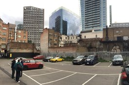
Rear of 2c-4a Commercial Street
Contributed by Shahed Saleem
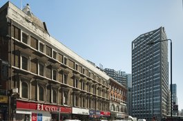
2C and 4A Commercial Street from the northwest in 2018
Contributed by Derek Kendall
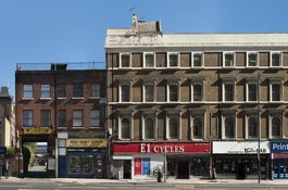
2 to 4A Commercial Street from the west in 2018
Contributed by Derek Kendall