The London Hospital Dental Institute and Students’ Union, Stepney Way
Contributed by Survey of London on Aug. 4, 2017
The area bounded by Stepney Way, Turner Street, Newark Street and New Road is
dominated by the former London Hospital Dental Institute and Students’ Union,
built in 1962–5 to designs by Stephen Statham & Associates, a little-known
architectural practice. This assertive block was the outcome of an ambitious
plan to unite and extend the hospital’s dental treatment, education and
research facilities. Between 1945 and 1952, the dental department and its
associated school tripled in size. This substantial block south of the
Outpatients Department was designed to accommodate 130,000 dental patients
each year and to permit a doubling of the annual admission of dentistry
students to 50. A large and highly specialized Dental Institute was
accompanied by a separate Students’ Union at the east end of the building. At
the time of writing (August 2017), the Dental Institute has fallen into
disuse, yet the adjoining Students’ Union continues as Barts and the London
Students’ Association.
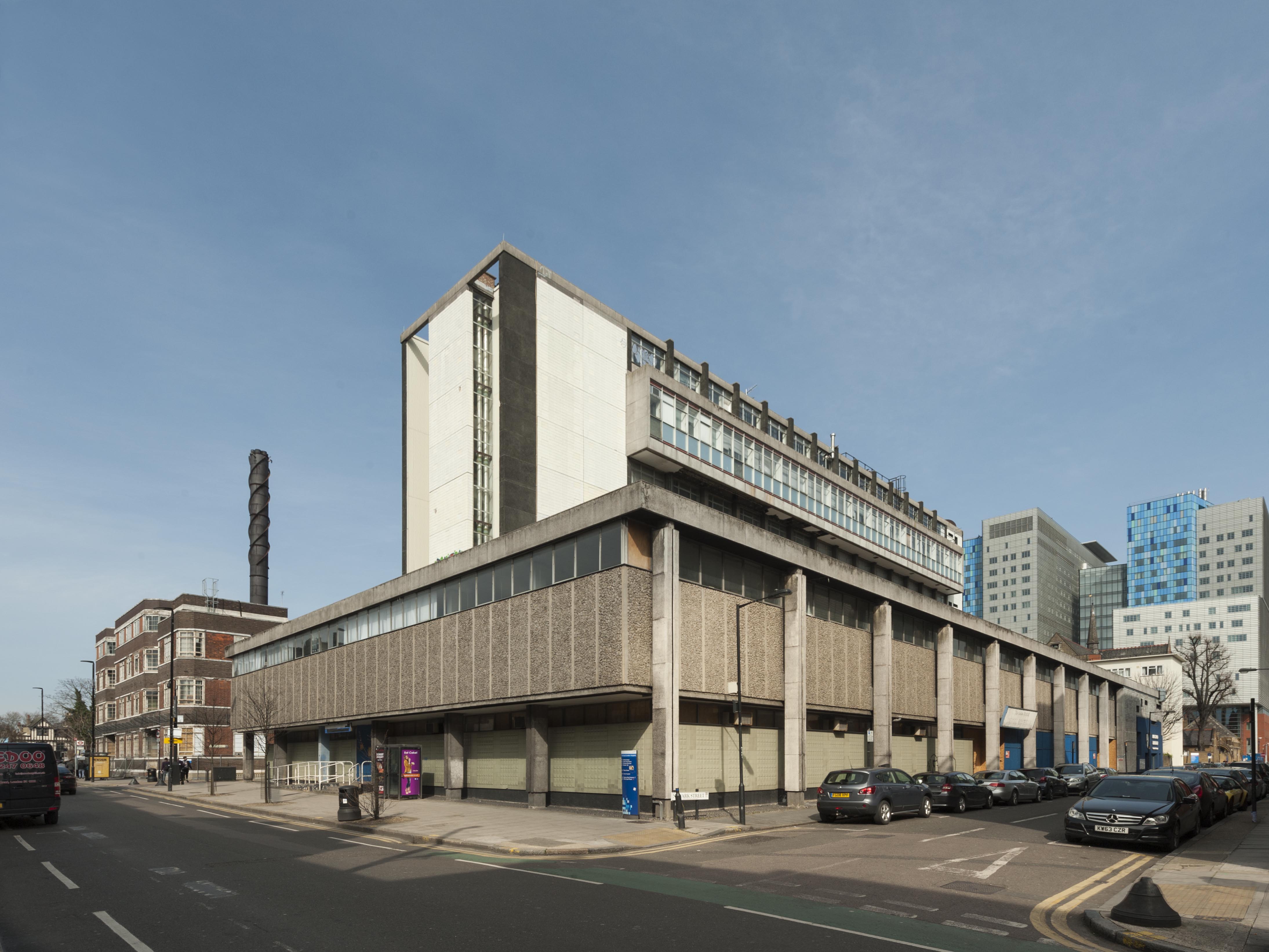
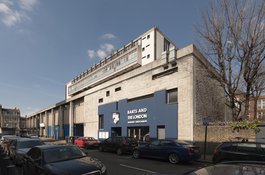
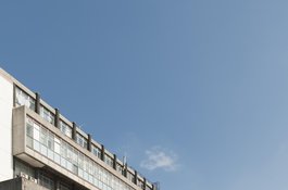
The London Hospital Dental Institute and Students’ Union from the south-west,
photographed by Derek Kendall in 2016.
The planning of the block spanned approximately five years, owing partly to
lengthy consultations with both the Ministry of Health and the University
Grants Committee (UGC), which financed the scheme jointly. The prolonged
evolution of its design may also be attributed to the building committee led
by the hospital and the medical college. An initial design was submitted to
the Ministry and UGC in 1957, yet the committee insisted on layout alterations
after its approval two years later. The final design was developed in
association with Oscar Faber & Partners, consulting engineers, and John
Liversedge & Associates, structural engineers. The block was constructed
in 1962–5 by Francis Jackson Contractors Ltd and a number of
subcontractors.
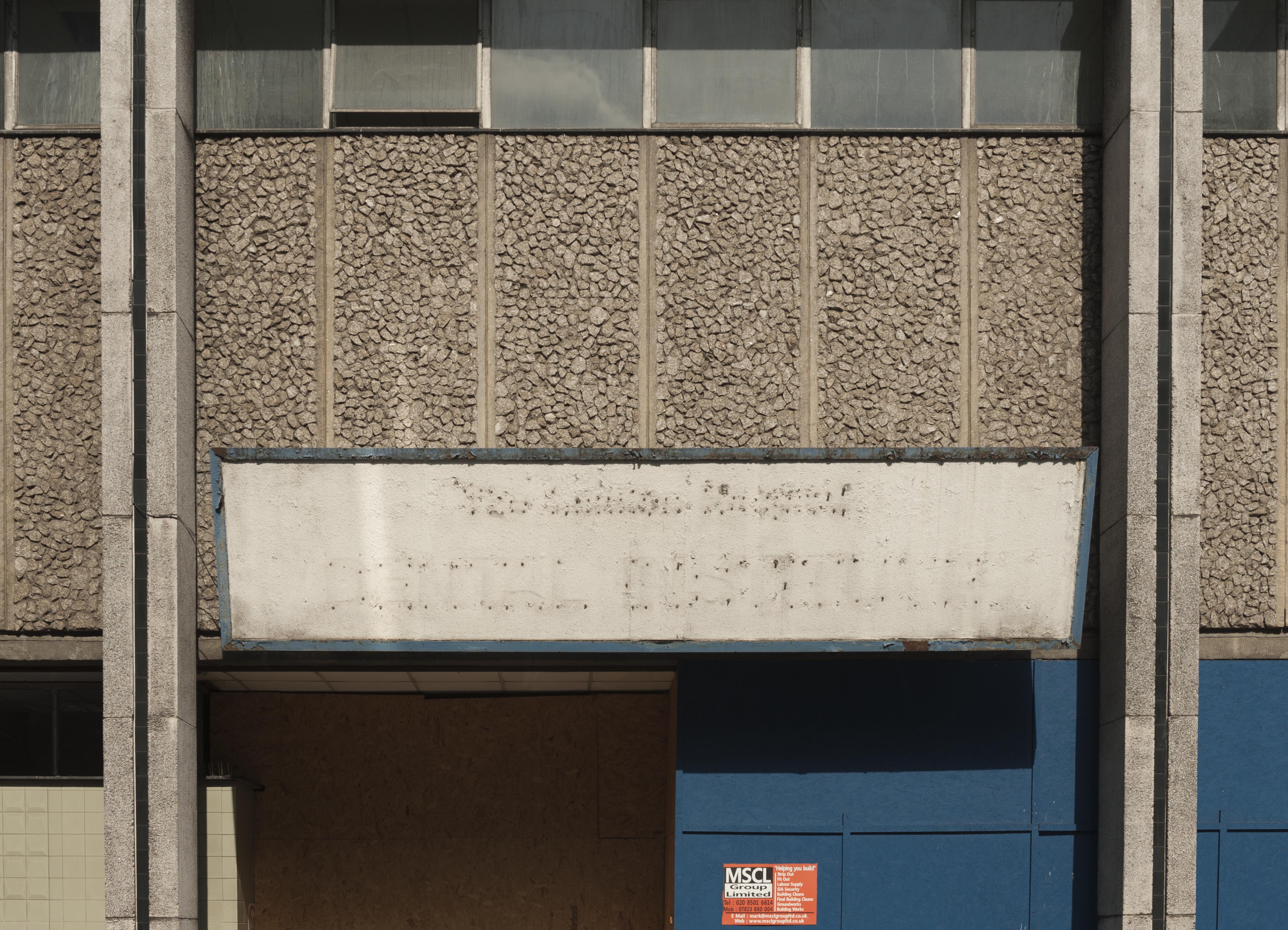
The Dental Institute and Students’ Union replaced three rows of early
nineteenth-century terraced houses at 52–64 New Road, 1–23 Newark Street and
2–26 Stepney Way. It is a bulky concrete block formed of a podium crowned by a
five-storey tower; a discordant configuration influenced by LCC restrictions
on height and floor area. The podium engulfs the entire site, while the tower
is limited to a narrow rectangular footprint with cantilevered projections on
the third and fifth floors. The reinforced-concrete frame is partly exposed
and the exterior walls clad with tiles and concrete panels. The south
elevation of the Students’ Association in Newark Street is marked by window
openings arranged with playful irregularity, while its north entrance facing
Stepney Way was originally clad with marble.
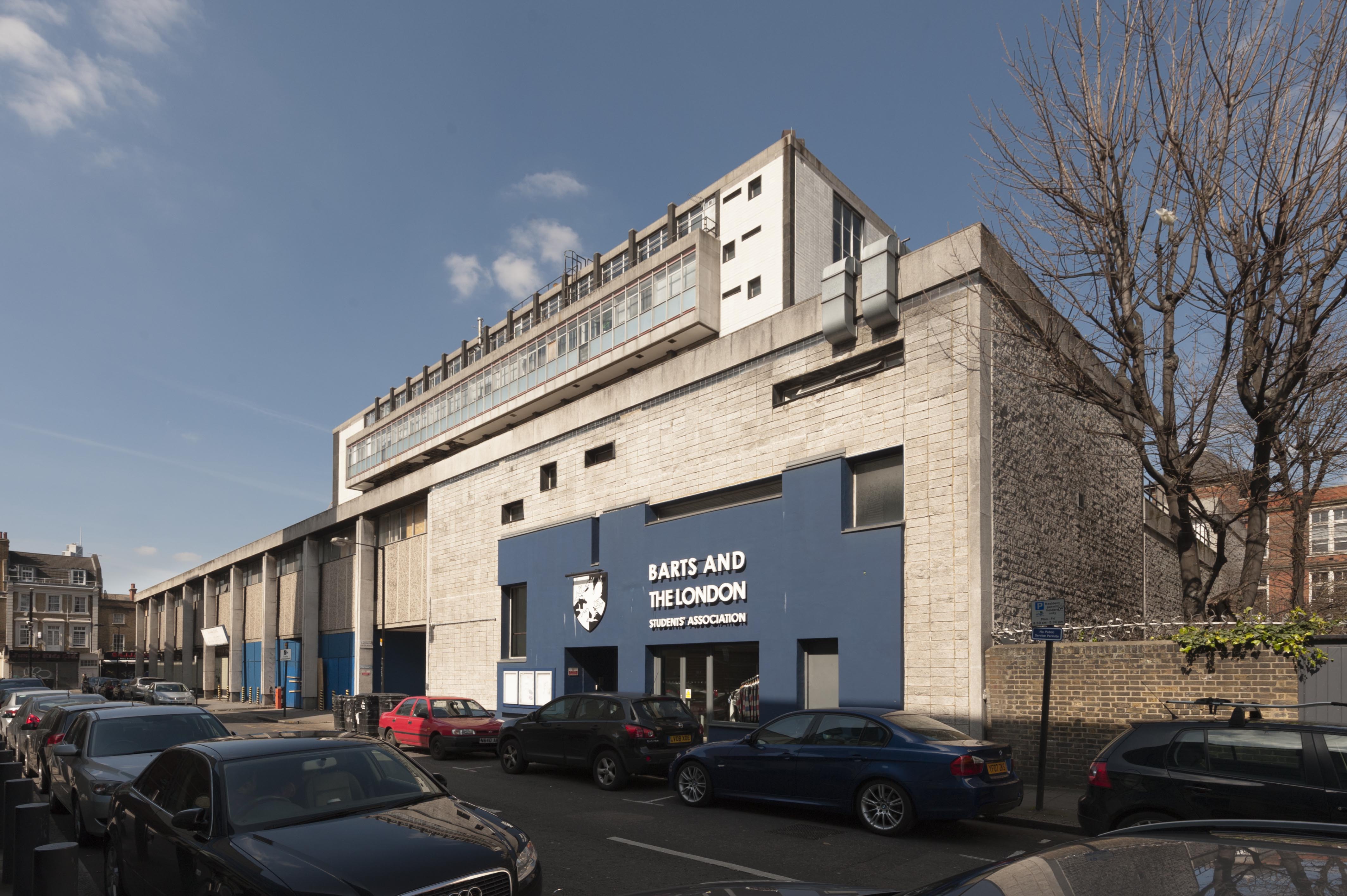
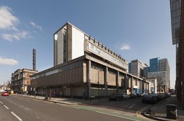
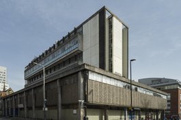
The south elevation of the Dental Institute and the Students' Union in Newark
Street, photographed by Derek Kendall in 2016.
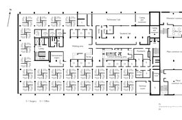
The block was divided into the Dental Institute west and the Students’ Union
east, separated on the ground floor by a central car park adjacent to staff
common rooms and lockers. The Students’ Union was limited to three storeys and
a basement compressed into the east end of the podium. A large dining room
occupied the centre of the ground floor, while the upper floors contained
three common rooms, and top-lit music and games rooms. The internal
configuration of the Dental Institute was highly specialized thanks to
collaboration between the architects and building committee. After its
completion in 1965, the institute was described triumphantly as ‘the
manifestation of a philosophy of dental treatment and education translated
into practical building terms’. An engineering workshop, a ‘hot’
laboratory and service plants were confined to the basement. The Dental
Institute originally lacked a street entrance, with its principal doorway for
staff and patients located next to the ground-floor car park and accessed via
footpaths from Stepney Way and Newark Street. The entrance foyer was flanked
by the Oral Surgery and Radiology Departments, each divided into suites by
light partitions. The arrangement of the first floor was a focus for the
architects and the building committee, who studiously tested models and
prototypes. The result was a central core comprising a sterilising department,
a waiting area, surgeries and offices, partially encircled by a treatment area
containing 92 dental chairs for patients. These were arranged in four-bay
clusters separated by low screens to ensure privacy.
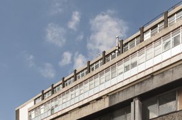
The north elevation of the Dental Institute in Stepney Way, photographed by
Derek Kendall in 2016.
The narrow upper floors of the five-storey tower were largely assigned to
dental education and research. The second floor contained a lecture theatre, a
photographic unit and offices, while a Department of Child Dental Health was
installed on the third floor. Each level followed a similar layout, with
central corridors terminating east and west in lobbies containing stairs and
lifts. Specialized rooms formed by light partitions flanked the corridors,
benefitting from exterior glazing. An exception was the fourth-floor teaching
department, which, by the inclusion of a south-facing corridor, secured a
seminar room, a laboratory, and a clinic devoted to practising dental
techniques on ‘phantom heads’, or mannequins. The fifth and sixth floors of
the building were dedicated to research and included an animal testing
facility.
It was later remarked that when the Dental Institute opened in September 1965,
the department ‘instantly foamed up and filled every corner of the
building’. A series of alterations followed, including the insertion of a
public street entrance in New Road. Plans were produced in 1978 to simplify
the first-floor treatment area by replacing the grouped dental chairs with
single fitted cubicles. Since the Institute of Dentistry transferred to the
hospital’s newly renovated Alexandra Wing in 2014, the west end of the block
has lapsed into disuse and the site has been earmarked for redevelopment.
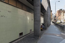
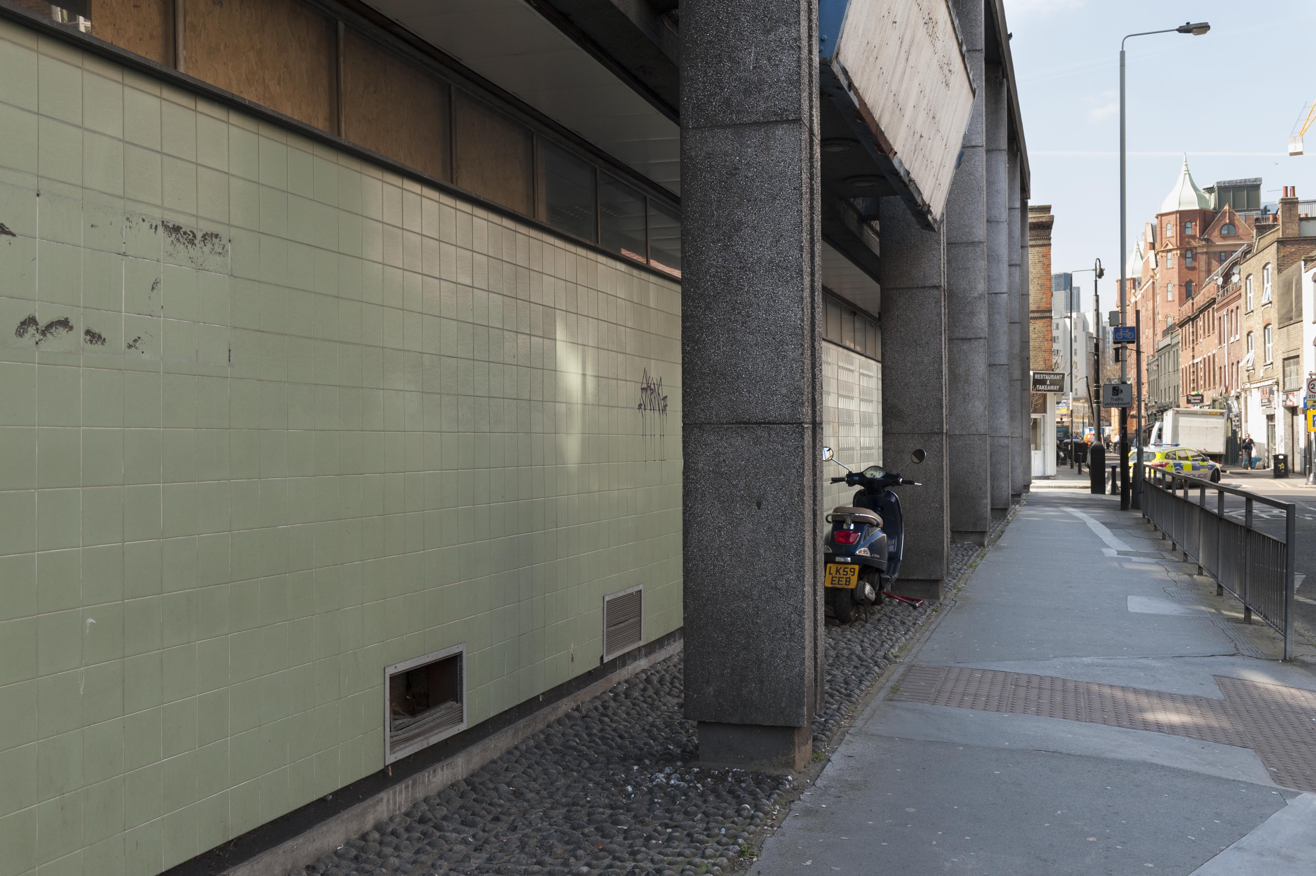
Former entrance to the Dental Institute in Newark Street, photographed by
Derek Kendall in 2016.
Stepney Way - some early history
Contributed by Survey of London on Aug. 18, 2020
Stepney Way follows the course of the footpath that linked Whitechapel’s field
gate to St Dunstan’s Stepney. It was formerly known as Oxford Street, perhaps
in compliment to Brasenose College, which held the advowsons of both
Whitechapel and Stepney from 1708. Groups of houses on the street were called
Hereford Terrace, Wellington Place, Raven Terrace and Hampshire Place till
1867. The present name was introduced in 1938.
Development this far north on the London Hospital's estate was restricted by
the concern attached to preserving air circulation around the hospital,
confining building plots to the street’s west and east ends. The south side of
the stretch between New Road and Turner Street was built up between 1807 and
1811, when the first leases for completed buildings were granted. Henry
Stevens took Nos 12–22, while smaller lots of one or two dwellings went to
John Henry Frith, Benjamin Cornish and Hannah Wilson. On the north side,
Robert Watson completed four terraced houses at Nos 9–15, while Robert
Shearsmith followed with another four at Nos 17–23 in 1815. Nos 1–7 were taken
in smaller lots of one or two dwellings between 1814 and 1819.
The eastern stretch of Stepney Way on the hospital estate was developed in the
1820s. The Brewers’ Company leased ground for a row of almshouses that went up
in 1825–6 to face St Philip’s Church across open ground. The British Oak
public house, next door to the east on the south side of Stepney Way at No.
28, was taken on a building lease by Elizabeth Humphreys in 1828. Adjoining
ground for a row of twelve houses had gone to John Symonds, John Jacobs, James
Hellyer and Spencer Lambert between 1823 and 1826. These stood opposite two
rows of eight houses between East Mount Street and Raven Street, also erected
in the 1820s. The block east of Milward Street was sold in 1875 to the East
London Railway Company, which demolished some houses for its railway cutting.
The Oxford Arms occupied No. 43 at the corner of Milward Street.
From the 1890s the hospital acquired sites along Stepney Way for the
rebuilding programme overseen by Rowland Plumbe (see p.xx). Only Nos 2–26
(south side west) and 37–49 (north side east) survived into the 1960s. No. 20
was the home of Isaac Sharp (1879–1965), a trade-union secretary and local
councillor, and Martha, née Belinsky (1881–1967), both Russian Jewish
immigrants. Their son, Eric Sharp (1916–1994), was born here. His business
career, ranging from Monsanto Ltd to Cable and Wireless, led to a peerage as
Baron Sharp of Grimsdyke under Margaret Thatcher.
Pector's restaurant at 64 New Road
Contributed by RozinaCowan on Oct. 31, 2018
My Booba and Zaida had a restaurant at this address. Their names were Chava
and Usher Pector My Dad came into the restaurant one day, saw my Mum and the
rest is history.
My family home
Contributed by henry on Oct. 25, 2018
I was born in 1949. My family lived at 18 Stepney Way and had been there from
the time it was called Oxford Street. The matriarch of the family was my
Booba, Sarah Steppel. My mother, her daughter Hetty, had married my father,
Eugen Grunwald, in 1942. He had arrived in the UK from Czechoslovakia on 4th
August, 1939, armed with a work permit. He had trained as a chef and the work
permit had been granted by Feld's
Restaurant on Whitechapel Road. He had lodged with my Booba and had
then married the landlady's daughter. They stayed living with my Booba, who
ruled the roost until her death in 1970. I attended Fairclough Street (later
Henriques Street) Infant
School and then followed
my sister, Frances, to Rutland Street Primary
School. Our shul was
New Road
Synagogue, where
I was barmitzvahed in 1962. The family shul had been Dunk Street, but that had
been bombed during the war. I was lucky enough, thanks to an inspirational
Head Teacher at Rutland Street, Mrs Giles, to get a scholarship to City of
London School. In 1960 or 61 my family moved to a small block of flats in
Myrdle Street, when 18 Stepney Way was demolished to make room for the Dental
School. I remained living there until I qualified at the Bar in 1972. My
parents remained there until they died, my father in 1998 and my mother in
2002. I have many fond recollections of the area.