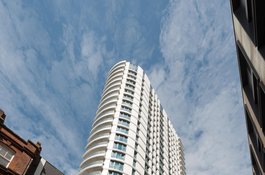
Altitude Point
2011-14, flats, offices and shops for Barratt Homes, on a site that included a workhouse, chapel/synagogue and the Jews' Infants' School | Part of Altitude Point
Little Alie Street - early history of its north side
Contributed by Survey of London on July 31, 2020
The north side of Little Alie Street was almost bookended by places of worship from the 1760s, a Baptist chapel to the east and a German Lutheran church to the west. Immediately beyond the Baptist chapel to the east was Whitechapel’s first parish workhouse. This was built in 1722–4, coinciding with Sir Edward Knatchbull’s Workhouse Test Act of 1723 that codified the practice of building parish workhouses, including provision that residence could be imposed as a condition of relief from poverty. It was designed to house about 200, but only five years after it opened it was deemed necessary to ‘turn it into a house for lodging only such poor as are not otherwise provided, who go out daily for work where they can get it, and return in the evening. There are now about 60 men, women and children, so lodged under the care of a mistress, who takes care to keep the house clean, and have the beds made ready for those that lodge there.’1 By 1734 there were only thirty resident, ‘who are not kept to work, but go and come as they please, get drunk, and are disorderly’.2 The failure was attributed to the confined site, without room for a yard to work in, it also being dirty on account of the proximity of white-lead works. An attempt to replace it then failed, but a much larger workhouse opened on Whitechapel Road in 1768, after which the Little Alie Street building was used as a warehouse. Five three-storey houses replaced it in the nineteenth century. Further east was Goodman’s Stile, where in the eighteenth century the roadway narrowed and a run of small houses on the north side was set back behind forecourts. Soon after 1800 those were lost to road widening that created a kink in the road. The Castle public house was here by 1770 until it moved to the newly formed Commercial Road corner in 1873. Three of the Goodman’s Stile houses were rebuilt in 1848–9.3
A breakaway congregation from Little Prescot Street led by James Fall built Little Alie Street Baptist Chapel in 1754. It was a simple building with a three-bay front, two entrances flanking a window, and was rectangular on plan with seatings for 400. Thomas Jordan & Co., brewers, had warehousing in the chapel’s cellar from around 1764 into the 1790s. From 1833 to 1871 the chapel’s congregation was led by Philip Dickerson who gathered up to 500 people at each of two main services, morning and evening.4 Decline followed, and in 1909 the chapel was adapted to use as a synagogue to plans by Lewis Solomon. A ladies’ gallery was inserted, and a classroom adjoined the main hall. A congregation of around 200 was formed through an amalgamation of six small societies, possibly including a group that had been meeting in a house on Buckle Street since at least 1899. The building was demolished around 1924.5
To the west of the Baptist chapel, Robert Girton, a silk throwster, had a large house from about 1726, possibly one of five-bay width that survived to about 1913. He was succeeded in the 1740s by Thomas Sharrer, another silk throwster, who was followed by John Sharrer, who moved the family’s silk- throwing business to Sherborne in Dorset in 1753–5, leaving Elizabeth Sharrer living and managing affairs on Little Alie Street until the late 1770s. The property was then described as being a house with ‘large workshops and other convenient offices’.6 Occupants of other good-sized three-storey houses further west included Samuel Petty (d. 1741), another silk throwster, whose house fell to use as a coal warehouse later in the century, and Richard Symonds, who was succeeded in the 1760s by the Rev. Dr Gustav Wachsel next door to the Lutheran church. All the other houses between the chapel and the church had come to house shops and workshops by the 1840s.7
-
An Account of Several Work-Houses for Employing and Maintaining the Poor, 1732, pp.67–8: London Metropolitan Archives (LMA), P93/MRY1/090; Land Tax Returns (LT): Kathryn Morrison, The Workhouse: A Study of Poor-Law Buildings in England, 1999, p.14 ↩
-
House of Commons Journals, vol.22, 1734, p.271 ↩
-
Richard Horwood's maps: Goad insurance plans: LMA, LT; District Surveyors Returns (DSR); Collage 116971 ↩
-
Tower Hamlets Local History Library and Archives (THLHLA), W/LAS/1–4: LT: Ordnance Survey maps (OS): The National ARchives (TNA), HO129/22/20: David Benedict, A General History of the Baptist Denomination in America and Other Parts of the World, 1850, p.339: Joseph Ivimey, A History of the English Baptists, vol.4, 1830, p.13: surveyoflondon.org/map/feature/987/detail/#note : www.stgitehistory.org.uk/media/dissenters1.html ↩
-
London Evening Standard, 13 Sept 1909, p.4: East London Observer, 18 Sept 1909, p.7: DSR ↩
-
Weekly Journal or British Gazetteer, 10 Oct 1726, p.10: Daily Advertiser, 20 Jan 1777, p.1: Gazetteer and New Daily Advertiser, 19 March 1777, p.4: LT: www.sherbornemuseum.co.uk/silk.php ↩
-
LT: TNA, PROB11/711/245: Post Office Directories ↩
The Plough Street area's pubs
Contributed by Survey of London on July 31, 2020
There were six licensed victuallers operating in and around Plough Street in the 1730s, but only two pubs survived into the nineteenth century. What had become the Half Moon and Punchbowl was on the south-east corner of Buckle Street and Plough Square. By the early 1880s it was a boarding house, like other neighbouring buildings, with many beds occupied by Germans. The Man in the Moon, on the south-west corner of Plough Street and Colchester Street, had fallen into disrepute on account of juvenile gambling. Around fifty youths were found inside betting on skittle grounds in 1845, and in 1850 young thieves were found ‘stooping over a strong fire’ in the basement.[^1]
By this time, the area’s residents were overwhelmingly Irish and German labourers. Densely inhabited streets were reportedly vexed by criminality, ranging from petty thefts, as when two orphaned Irish boys plundered lead and timber from unoccupied houses in Plough Street, to haunting tales of abuse and violence at the hands of tradesmen and drinkers. A ragged school was founded on Braham Street in the early 1850s, formally partnering with the Shoe-Black Society in 1854.[^2]
[1]: Morning Advertiser, 24 July 1850, p.4; 12 June 1840, p.4; 6 Oct 1860, p.7: London Metropolitan Archives, MR/LV/05/026: Ordnance Survey maps: Post Office Directories: Census: London Evening Standard, 12 Sept 1845, p.8; 31 Oct 1849, p.4: Morning Chronicle, 1 June 1852, p.8: East London Observer, 4 May 1878, p.1
[2]: Ragged School Union Magazine, vol.6, 1854, p.224: London Evening Standard, 31 May 1858, p.7: Census
Late Victorian schools and other developments north of Little Alie Street
Contributed by Survey of London on July 31, 2020
Irish and German settlement in the Little Alie Street area generally gave way to a Jewish population in the late nineteenth century, with tailoring predominant by way of employment.1On the south side of Buckle Street’s east end the Half Moon and Punchbowl pub and six houses were cleared to make way for a branch of the voluntary-aided Jews’ Infants’ School, which was built by Harris & Wardrop in 1888 and opened in March 1889 to provide education for children aged three to seven. The institution had its origins in 1841 on Houndsditch. It branched to Commercial Street in Spitalfields in 1856–8 and the Buckle Street establishment was another extension, replacing a smaller facility on East Tenter Street. The substantial Buckle Street school, which had a part-covered rear playground with a detached range of WCs, allowed an additional 1,000 children to receive religious and secular instruction. It was plausibly claimed as being among the largest infants’ schools in England.2
The Jews’ Infants’ School was widely admired for its progressive approach. Inspectors lauded the teaching, ‘children {are} not only taught but also educated’.3 The headmistress, Miss Pizer, had by 1912 structured teaching on Froebelian methods, emphasizing ‘natural’ play, storytelling and self- expression. The spaciousness of the building permitted free movement, and a dado of green linoleum was for infants to learn through drawing. One visitor reported that the parquet floor allowed the children to ‘romp to their hearts’ content without making too much noise’.4 The school continued until it suffered bomb damage in the Blitz. The empty building was acquired by a Jewish sweet-making firm in 1954. It was replaced by a four-storey warehouse around 1960.5
Another significant educational initiative of the same period in this locality was the Whitechapel Craft School, opened in January 1891 by J. D. Sedding, at 27 Alie Street, the early five-bay house to the east of the German school, which had previously seen use as a cigar factory. This school had its origins in links made at Toynbee Hall and through C. R. Ashbee’s Guild of Handicraft. Hubert Llewellyn Smith led the project and acted as Secretary, the governing committee included Ernest Gimson. The first-floor front room was used as both a drawing school and a workshop for carving, modelling and metalwork. The back room was a museum. Upper floors were ‘manual workshops’. Men and ‘lads’ with backgrounds in building and furnishing trades were encouraged to develop their approaches to design through the educational methods of both Froebel and Pestalozzi. The school gained LCC support in 1894 and moved to a church on Globe Road in 1896.6After the development of Commercial Road’s newly formed southern frontage in the mid 1870s, Buckle Street and Plough Street were more generally redeveloped. The Man in the Moon public house was rebuilt and enlarged in view of the new road in 1877–8. Several old houses were replaced by blocks of five- and six-storey dwellings in 1882–3, including Buckle Street Buildings, on the north side to the east, and Plough Street Buildings at the junction’s north-west corner. When two large shops were advertised for let on Plough Street in 1881, they were said to be located in ‘a neighbourhood surrounded by Model Dwellings’.7 On inspection by John Liddle, the Medical Officer for Health, in 1883, Plough Street Buildings comprised eighty-three rooms above ground-floor shops. Seventy-nine of the rooms were inhabited by 178 people, of whom eighty-seven were children, ‘the lower order of foreigners, and very dirty’.8 The closure of a ‘Whitechapel Fever Den’ in an old house on Plough Street in 1885 reinforced fears of insanitary conditions and overcrowding in the new buildings, but the tone of reports calmed and by 1897 overcrowding was said to have abated to a reasonable level.9
In 1893–4 Nathaniel and Raphael (Ralph) Davis built a block of six four-storey houses with shops and top-floor workshops on the south side of Alie Street returning to the east side of Rupert Street. The west end of the south side of Buckle Street (Nos 24–26) was redeveloped in 1899 as houses and workshops, with a synagogue formed at No. 26.10
-
Census: East London Observer (ELO), 2 June 1888, p.3 ↩
-
The Builder, 16 Nov 1861, pp.784–5: Globe, 6 March 1889, p.4: London Daily News, 7 March 1889, p.7: Jewish Chronicle (JC), 26 May 1893, p.2; 10 Jan 1896, p.18; 23 Oct 1896, p.17; 13 Nov 1896, p.2: Truth, 10 Jan 1895, p.8: Morning Post, 21 Jan 1897, p.3: London Metropolitan Archives, District Surveyors Returns (DSR) ↩
-
JC, 23 Oct 1896, p.17; 24 April 1896, p.15 ↩
-
Pall Mall Gazette, 28 Dec 1912, p.12: ELO, 14 Sept 1912, p.3 ↩
-
Post Office Directories: Ordnance Survey maps (OS): The National Archives (TNA), ED21/57365: JC, 11 March 1955: Tower Hamlets planning applications online ↩
-
TNA, ED27/3238: fairfaxcholmeley.com/east-end-and-toynbee/the-craft- school-1890-1915/ ↩
-
ELO, 26 Nov 1881, p.8; 14 Nov 1891, p.4: Daily Telegraph & Courier (London), 27 June 1881, p.8: DSR: OS ↩
-
The Builder, 16 June 1883, p.833: Globe, 8 June 1883, p.3 ↩
-
ELO, 20 June 1885, p.3: Tower Hamlets Independent and East End Local Advertiser, 25 Dec 1897, p.7 ↩
-
DSR ↩
Louis London & Sons' clothing factory
Contributed by Survey of London on July 31, 2020
Louis London & Sons’ clothing factory replaced four houses on Alie Street immediately east of the German school in 1913. Founded in 1859, this firm moved from Houndsditch and Middlesex Street (Petticoat Lane) to a large, amply fenestrated, symmetrically fronted, seven-bay, four-storey building. Hobden and Porri of Finsbury Square were the architects, Sheffield Bros of Shacklewell the builders. The premises were modestly enlarged at the back in 1915 and then significantly extended eastwards in 1924–6 across the former Baptist chapel and synagogue site, again throughHobden and Porri, with Albert Monk of Lower Edmonton as the builder. Further snaking extension up to Goodman’s Stile was carried out in 1939, Henry Kent of Lewisham being the builders. The Louis London label had fashionable allure, a showroom opened in Henrietta Place in Marylebone in 1946 and factories were established outside London. Queen Elizabeth II visited Alie Street to mark the firm’s centenary in 1959. Other rag-trade businesses succeeded and the factory survived until about 2009, proposals for its conversion to flats from 1996 to 2002 coming to nothing.1
-
Daily Telegraph & Courier (London), 20 March 1900, p.13: East London Observer, 2 March 1912, p.8; 17 June 1916, p.4: Sunday Mirror, 31 Jan 1926, p.13: Western Daily Press, 19 March 1928, p.2; 22 July 1930, p.2: Yorkshire Evening Post, 21 Oct 1935, p.3: Manchester Evening News, 24 Dec 1940, p.5: The Tatler, 13 Nov 1946, p.33: LMA, District Surveyors Returns; Collage 1116971: Wiltshire and Swindon History Centre, 1387/706: Tower Hamlets planning applications online: www.aliestreet.com/uk/occasionwear/info/history.html ↩
71 (Altitude Point) and 81 Alie Street with 9 Buckle Street (Goldpence Apartments) and John Sessions Square
Contributed by Survey of London on July 31, 2020
The former Louis London factory on Alie Street and a warehouse that replaced the Jews’ Infants’ School on Buckle Street were combined for Inonder Ltd (incorporated in Jersey) for a large development project. A first scheme of 2004 designed by Humphrey Cook Associates, architects, was withdrawn. The project was taken through planning in 2007–8 to designs by Hamiltons Architects. It was built in 2011–14 for Barratt London in a joint venture with L&Q, the housing association that originated as London and Quadrant, to revised designs by BFLS Architects that were delivered by RMA Architects. Getjar Ltd was the contractor, Silcock Dawson & Partners the engineers. The complex is dominated by a twenty-seven storey tower (Altitude Point) that is a residential block of 235 flats on a four-storey podium housing commercial and retail use. The lowest seven storeys include social housing, sixty-four ‘affordable’ flats, known as Goldpence Apartments and accessed separately to the rear on Buckle Street where the Consulate of Ecuador has adjacent tenure. A seven-storey office building to the east at 81 Alie Street lies beyond a landscaped passage linking Alie Street and Buckle Street that has been named John Sessions Square. Through this development Tower Hamlets Council secured more than £2m in Section 106 contributions to local improvements. With rounded shiny white neo-Moderne surfaces, and massing that is more bulbous than curvaceous, Altitude Point lords its anti-contextual height in fabric as in name.1
-
Tower Hamlets planning applications online: Building Design, 15 Dec 2010: www.skyscrapercenter.com/building/altitude-aldgate/18702 ↩
The impetus for the Strict Baptist church on Little Alie Street (now demolished)
Contributed by Alison_B_and_Fiona_D on May 24, 2018
Stephen Williams, a little-known, but significant member of the Strict Baptist church at Little Prescott Street (what is now the furthest south extension of Mansell Street), was influential in the appointment of Samuel Burford [c. 1726-1768] as minister of the church in the mid-eighteenth century. In the end, this appointment also resulted in the establishment of a new Strict Baptist church at Little Alie Street.
After the death of the previous minister, the minute books of the church show that James Fall had been proposed to take the deceased minister’s place, but in an election held in 1753, votes against his appointment narrowly outnumbered those in favour by four. The minutes show that Stephen Williams voted against Mr Fall’s appointment and it is quite possible that Williams had Samuel Burford in mind for the post, Williams’ sister Hannah having married into the Burford family. However, despite doubts shown by some members of the congregation, the minutes state that on 27th April 1755, 'The Church unanimously chose him [Burford] and thought proper to give him a call'. The passing over of James Fall led to the setting up of his own church at Little Alie Street.
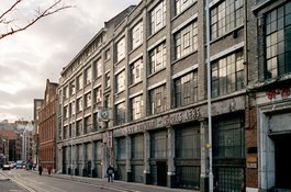
Alie Street 1998, view looking west
Contributed by Chris Redgrave
Alie Street looking north, August 2017
Contributed by Derek Kendall
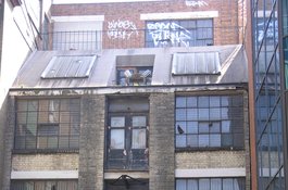
Buckle Street
Contributed by stephen
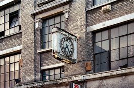
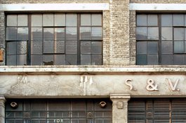
Detail of Lewis London & Sons, 1998, photo by Chris Redgrave
Contributed by Chris Redgrave
Detail of Lewis London & Sons, 1998, photo by Chris Redgrave
Contributed by Chris Redgrave