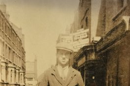
Old Montague Street's early history
Contributed by Survey of London on March 30, 2017
Taking its name from the family that acquired the land hereabouts in 1643,
Montague Street was in existence from about that time. In the 1680s another
Montague Street was laid out close by to the north in Spitalfields (this later
became part of Hanbury Street). By the 1790s the street in Whitechapel was
regularly differentiated by a prefatory ‘Old’. The road was largely built up
by 1700 and pubs included the Half Moon and Seven Stars, documented as present
around 1730, and the King of Prussia’s Head, around 1770 by when the Cock and
Key was on the south side, east of King's Arms Court, eventually No. 52. By
1840 the Cock and Key had become the Commodore. There was also the Black Bull,
later if not always at what was eventually renumbered as No. 24 on the south
side. John Frostick, the Black Bull’s victualler by the 1780s, owned property
on the east side of Brick Lane. He or another John Frostick was a carpenter at
a house on the site of No. 5 on the street’s north side, adjacent to what is
now Frostic Walk, previously Frostic Place, which had a few houses on its east
side by the 1790s. It had been preceded by Montague (later Manby Court).
Early Jewish presence appears to be represented by Moses Israel Brandon, a
tobacconist on the north side in 1787. Joshua Levy was refining sugar on the
street by the 1820s and by 1832 Kaufman Meyers, a cane umbrella stick and rib
manufacturer and dealer in Russia mats, was at the top end of Osborn Street’s
east side. With sugarbaking and distilling having been established to the
south and dying to the north in the eighteenth century, it is unsurprising
that other noxious trades arrived in the early nineteenth century, among them
soapmaking, lamp-black manufacturing and scum-boiling. Courts of tiny two-
storey houses were squeezed in: Montague Place (fourteen) between what became
Nos 30 and 32 and backing on to Size Yard, and Easington Buildings (sixteen)
between Nos 46 and 48 just west of King’s Arms Court, where the census of 1891
recorded 98 residents.
Later nineteenth-century rebuildings for small houses and tenements included
Nos 47–63, a row of 1887 called Pauline Terrace, and Nos 66–70 (Montague
Houses) on the east side of Black Lion Yard, a tenement block of 1891–2 put up
by Davis Brothers. By 1898 the street was ‘all Jews’, shopkeepers living above
their premises. In 1909 a Passover Cake oven was built to the rear of the
Black Bull, and in 1911 the pub was converted to shop use.
The Chevrah Shass Synagogue (demolished) stood to the rear of 42 Old
Montague Street, its name being Hebrew for ‘society for studying the Talmud’.
A group that may have originated in 1875 settled here around 1896 through the
conversion of a toplit warehouse. As at the nearby Great Garden Street
Synagogue, which was somewhat larger, the building was squarish on plan and
given galleries. Its entrance at the end of a short alley was distinguished
through the reuse of ornamental double doors salvaged from Astley’s Royal
Amphitheatre on Westminster Bridge Road. The synagogue was wound up by the
Federation of Synagogues in 1959, and demolished in 1971–2 as part of a wider
clearance programme.
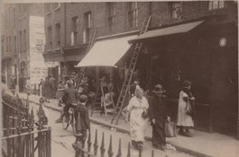
Old Montague Street remained generally low-rise retaining a number of open-
fronted shops. In the early 1960s No. 36 was the Star India Sweet Meat Mart
(Nawab Din, lessee, living with a family of eight above), and No. 44 was
Eastern Grocers (Abdul Hannan Moklis Faron Miah Mazemmil Ali, lessee, with
another eight or nine living above). Yet to Emanuel Litvinoff Old Montague
Street remained the ‘heart’ of the Jewish quarter even in the 1970s, and
Raphael Samuel looked back in the 1980s and recalled it as ‘the nearest thing
in the East End to the way I imagined a shtetl … In its last days it still
seemed to be an entirely Jewish street with vats of pickled herring occupying
strategic places on the pavements, and shops which served customers at the
window for want of internal space. Shops with no names but forcefully present
proprietors.’
The Greater London Council planned slum clearance around Old Montague Street
from 1961. By 1968 the entire stretch of Nos 16–78 on the south side with
attendant courts was set to go, but most of the demolition there happened in
the 1970s. Clearance of the north side followed on, as part of the Hopetown
Estate development.
Hopetown, 60 Old Montague Street
Contributed by Survey of London on March 30, 2017
The Salvation Army’s women’s hostel on the south side of Chicksand Street
known as Hopetown moved to Old Montague Street to make way for the Greater
London Council’s Hopetown Estate development, against the wishes of Tower
Hamlets Council which wanted fewer hostels in the borough. With Black Lion
Yard and the south side of Old Montague Street cleared, the Salvation Army was
given this site, larger than that on Chicksand Street, and the hostel went up
in 1977–9 and was formally opened by Queen Elizabeth II on 20 February 1980.
The project was undertaken by the Salvation Army Housing Association Ltd with
the GLC and the Department of the Environment, and designed by the Salvation
Army’s own architects under David Blackwell (John M. Maxwell, job architect).
It used Broderick lead-faced panel cladding and had 107 beds in three-storey
flat-roofed blocks, mostly in individual rooms in place of the predecessor’s
dormitories.
The Salvation Army Housing Association wholly replaced this building in 2005–7
for supported housing (109 beds), eighteen bedsits and a disabled unit in
four-storey blocks with polychrome brick facing. Designed in 2003 by Swanke
Hayden Connell Architects, this project was seen through by Darren Bland,
architect. Still called Hopetown, the premises continued as what the Salvation
Army refers to as a Lifehouse for homeless women up to the end of 2017. The
women were then displaced to make space for men following the closure of the
Salvation Army’s Booth House (see p.xx). The building was renamed Founder’s
House to downplay the association with women.
When I was still in primary school we had our first Asian child join the
class, her name was Mena and she lived in the tenement houses in Old Montague
Street. She lived at the very top and she was the only member of the family
that spoke English. She invited me back one day to her flat and we walked up
the tenement stairs. All I could smell was the spices and all these wonderful
aromas. There was a big double brass bed and they had boxes under the bed -
all their worldly goods. The kitchen was partitioned off with a curtain. The
bathroom and the toilet were down one flight. The mother welcomed me and,
because she didn't have any English food as such, she'd bought a packet of
Jacob's Cream Crackers with a pot of strawberry jam especially for me. She put
it on a plate and she gave it to me. I thought, 'I don't want that, I want
what I can smell. Give me some of that!' but I ate the crackers and the
strawberry jam.
It was opposite a kosher butcher that sold chickens on Old Montague Street.
The building was a three-storey tenement block. There was a whole row of them
and she lived on the very top floor. The building is now gone.
Next door to the chicken shop there was a greengrocers. It was a brother and
sister that owned it and they lived above the shop. If my mother ran out of
vegetables she would send me round there to knock on the side door and say
'Mum's run out of potatoes, or vegetables…Can she have some?' The shopkeeper
would go into the shop and then give some produce to me and I would run home.