HTTP 200 OK
Allow: GET, HEAD, OPTIONS
Content-Type: application/json
Vary: Accept
{
"count": 1747,
"next": "https://surveyoflondon.org/api/v1/images/?format=api&page=10",
"previous": "https://surveyoflondon.org/api/v1/images/?format=api&page=8",
"results": [
{
"id": 800,
"title": "Magdalen Passage and Cafe Spice Namaste, looking east along Prescot Street, August 2017",
"author": {
"id": 27,
"username": "DerekKendall"
},
"feature": {
"id": 1291,
"type": "Feature",
"geometry": {
"type": "MultiPolygon",
"coordinates": [
[
[
[
-0.070839769786207,
51.511534824904025
],
[
-0.070585471149656,
51.51157481222347
],
[
-0.07051545384739,
51.51139090854125
],
[
-0.070759436998916,
51.511351044073685
],
[
-0.070839769786207,
51.511534824904025
]
]
]
]
},
"properties": {
"b_number": "16",
"b_name": "",
"street": "Prescot Street",
"address": "16 Prescot Street",
"feature_type": "WHITECHAPEL_BUILDING",
"count": 4,
"search_str": "16 Prescot Street"
},
"tags": []
},
"file": "https://surveyoflondon.org/media/uploads/features/1291/SoL%20Whitechapel%20101525.jpg",
"description": "",
"copyright": true,
"created": "2017-09-12"
},
{
"id": 1235,
"title": "Mosiac floor at entrance, March 2018",
"author": {
"id": 27,
"username": "DerekKendall"
},
"feature": {
"id": 1297,
"type": "Feature",
"geometry": {
"type": "MultiPolygon",
"coordinates": [
[
[
[
-0.071935648282288,
51.51134524228436
],
[
-0.071874729442993,
51.51121363108998
],
[
-0.071816144948546,
51.51122339231668
],
[
-0.071776588646252,
51.51120578254433
],
[
-0.071762024560661,
51.51117337877791
],
[
-0.07177649375904,
51.511141452410264
],
[
-0.071834141993347,
51.51113011940239
],
[
-0.071816329795347,
51.51108571239466
],
[
-0.072075019832766,
51.51104549229583
],
[
-0.072193056743033,
51.51130853787665
],
[
-0.072151551976597,
51.51131487321276
],
[
-0.072147312228886,
51.51132649961524
],
[
-0.072142333320455,
51.51133343542439
],
[
-0.072015847069243,
51.5113547481352
],
[
-0.071996105248008,
51.51135617797319
],
[
-0.071982278923131,
51.511350687404345
],
[
-0.071975230627282,
51.51134004502751
],
[
-0.071935648282288,
51.51134524228436
]
]
]
]
},
"properties": {
"b_number": "",
"b_name": "Roman Catholic Church of the English Martyrs",
"street": "Prescot Street",
"address": "Roman Catholic Church of the English Martyrs",
"feature_type": "WHITECHAPEL_BUILDING",
"count": 20,
"search_str": "Roman Catholic Church of the English Martyrs"
},
"tags": []
},
"file": "https://surveyoflondon.org/media/uploads/features/1297/SoL%20Whitechapel%20101895.jpg",
"description": "",
"copyright": true,
"created": "2018-03-27"
},
{
"id": 599,
"title": "40 Osborn Street, April 2017",
"author": {
"id": 27,
"username": "DerekKendall"
},
"feature": {
"id": 135,
"type": "Feature",
"geometry": {
"type": "MultiPolygon",
"coordinates": [
[
[
[
-0.070296830059495,
51.517140381348035
],
[
-0.070243489335178,
51.51715485841291
],
[
-0.070243484523593,
51.51715486492166
],
[
-0.069949354933153,
51.51721490683748
],
[
-0.069900676223209,
51.51715243970377
],
[
-0.069976391684036,
51.51712406633498
],
[
-0.070054978589243,
51.51714635214166
],
[
-0.070266562539049,
51.51709543058367
],
[
-0.070285546286685,
51.51712501900623
],
[
-0.070296830059495,
51.517140381348035
]
]
]
]
},
"properties": {
"b_number": "40",
"b_name": "",
"street": "Osborn Street",
"address": "40 Osborn Street",
"feature_type": "WHITECHAPEL_BUILDING",
"count": 2,
"search_str": "40 Osborn Street"
},
"tags": []
},
"file": "https://surveyoflondon.org/media/uploads/features/135/SoL%20Whitechapel%20100681.jpg",
"description": "",
"copyright": true,
"created": "2017-05-03"
},
{
"id": 828,
"title": "Entrance to St Mark Street from Alie Street, August 2017",
"author": {
"id": 27,
"username": "DerekKendall"
},
"feature": {
"id": 72,
"type": "Feature",
"geometry": {
"type": "MultiPolygon",
"coordinates": [
[
[
[
-0.071316172609629,
51.513357644448156
],
[
-0.071381536247678,
51.51333354226256
],
[
-0.071506721638922,
51.51348338013621
],
[
-0.071436048599138,
51.513506199433145
],
[
-0.071316172609629,
51.513357644448156
]
]
]
]
},
"properties": {
"b_number": "28",
"b_name": "",
"street": "St Mark Street",
"address": "28 Alie Street (formerly 1 St Mark Street)",
"feature_type": "WHITECHAPEL_BUILDING",
"count": 3,
"search_str": "28 Alie Street (formerly 1 St Mark Street)"
},
"tags": []
},
"file": "https://surveyoflondon.org/media/uploads/features/72/SoL%20Whitechapel%20101561.jpg",
"description": "",
"copyright": true,
"created": "2017-09-12"
},
{
"id": 503,
"title": "18-24 Whitechapel Road in about 1890",
"author": {
"id": 2,
"username": "surveyoflondon"
},
"feature": {
"id": 151,
"type": "Feature",
"geometry": {
"type": "MultiPolygon",
"coordinates": [
[
[
[
-0.067489517623501,
51.51687130623368
],
[
-0.06743875487005,
51.51689358023796
],
[
-0.067266090420819,
51.51673533918469
],
[
-0.067320529547644,
51.51671694006739
],
[
-0.067489517623501,
51.51687130623368
]
]
]
]
},
"properties": {
"b_number": "24",
"b_name": "",
"street": "Whitechapel Road",
"address": "24 Whitechapel Road",
"feature_type": "WHITECHAPEL_BUILDING",
"count": 2,
"search_str": "24 Whitechapel Road"
},
"tags": [
"Amos Eaton",
"Buck & Hickman",
"Fasham Venables",
"Henry Hyman Collins"
]
},
"file": "https://surveyoflondon.org/media/uploads/features/151/18-24%20Whitechapel%20Road%2C%20c1890%20(1)%20b%2Bw.jpg",
"description": "",
"copyright": false,
"created": "2017-02-28"
},
{
"id": 269,
"title": "North elevation of the Dental Hospital and Institute of Dentistry (overlooking Stepney Way) in 2016",
"author": {
"id": 27,
"username": "DerekKendall"
},
"feature": {
"id": 1166,
"type": "Feature",
"geometry": {
"type": "MultiPolygon",
"coordinates": [
[
[
[
-0.062351470894244,
51.51718815629615
],
[
-0.061292929801261,
51.51728379235413
],
[
-0.061222794483401,
51.51696856036261
],
[
-0.062282192019856,
51.516876806223415
],
[
-0.062351470894244,
51.51718815629615
]
]
]
]
},
"properties": {
"b_number": "",
"b_name": "",
"street": "Stepney Way",
"address": "Dental Hospital and Institute of Dentistry",
"feature_type": "WHITECHAPEL_BUILDING",
"count": 13,
"search_str": "Dental Hospital and Institute of Dentistry"
},
"tags": [
"Dental Institute",
"London Hospital",
"Royal London Hospital",
"Stephen Statham & Associates",
"Students' Union"
]
},
"file": "https://surveyoflondon.org/media/uploads/features/1166/SoL%20Whitechapel100142.jpg",
"description": "",
"copyright": true,
"created": "2016-08-17"
},
{
"id": 448,
"title": "The Church of St Mary Matfelon, Whitechapel, in May 1941",
"author": {
"id": 37,
"username": "HistoricEngland"
},
"feature": {
"id": 296,
"type": "Feature",
"geometry": {
"type": "MultiPolygon",
"coordinates": [
[
[
[
-0.069238538289603,
51.51610506120929
],
[
-0.069007097235987,
51.5162239535272
],
[
-0.068282200256798,
51.51654369745104
],
[
-0.068157401560378,
51.51641994527148
],
[
-0.067807959279103,
51.51600137496063
],
[
-0.068541180339468,
51.515783257348254
],
[
-0.068555919008956,
51.51580580160597
],
[
-0.068713893455475,
51.515872451567986
],
[
-0.068778503699218,
51.51586114158782
],
[
-0.068817146392177,
51.515922550138725
],
[
-0.068888047037903,
51.51596428315636
],
[
-0.069016085124709,
51.515921053627785
],
[
-0.069107698271647,
51.51601562404751
],
[
-0.069243279190738,
51.515974904669626
],
[
-0.069238538289603,
51.51610506120929
]
]
]
]
},
"properties": {
"b_number": "",
"b_name": "Altab Ali Park, including the site of the parish church of St Mary Matfelon",
"street": "Whitechapel Road",
"address": "Altab Ali Park",
"feature_type": "OPEN_SPACE",
"count": 32,
"search_str": "Altab Ali Park, including the site of the parish church of St Mary Matfelon"
},
"tags": []
},
"file": "https://surveyoflondon.org/media/uploads/features/296/St%20Mary%20Matfelon%2C%209-5-1941%2C%20HELR%20F237%20copy.jpg",
"description": "",
"copyright": true,
"created": "2016-11-15"
},
{
"id": 600,
"title": "24-30 Osborn Street, April 2017",
"author": {
"id": 27,
"username": "DerekKendall"
},
"feature": {
"id": 128,
"type": "Feature",
"geometry": {
"type": "MultiPolygon",
"coordinates": [
[
[
[
-0.070121634693404,
51.516869543344676
],
[
-0.069926858193874,
51.51692095476887
],
[
-0.069899297441953,
51.51688000406167
],
[
-0.07009538632603,
51.51682863215052
],
[
-0.070121634693404,
51.516869543344676
]
]
]
]
},
"properties": {
"b_number": "24",
"b_name": "",
"street": "Osborn Street",
"address": "24 Osborn Street",
"feature_type": "WHITECHAPEL_BUILDING",
"count": 2,
"search_str": "24 Osborn Street"
},
"tags": []
},
"file": "https://surveyoflondon.org/media/uploads/features/128/SoL%20Whitechapel%20100684.jpg",
"description": "",
"copyright": true,
"created": "2017-05-03"
},
{
"id": 847,
"title": "Looking north from South Tenter Street, August 2017",
"author": {
"id": 27,
"username": "DerekKendall"
},
"feature": {
"id": 25,
"type": "Feature",
"geometry": {
"type": "MultiPolygon",
"coordinates": [
[
[
[
-0.072224142932504,
51.51204117669345
],
[
-0.07219173055747,
51.511959798664655
],
[
-0.072247981809045,
51.511951551759914
],
[
-0.072275814795124,
51.51203408325769
],
[
-0.072224142932504,
51.51204117669345
]
]
]
]
},
"properties": {
"b_number": "2",
"b_name": "",
"street": "Scarborough Street",
"address": "2 Scarborough Street",
"feature_type": "WHITECHAPEL_BUILDING",
"count": 3,
"search_str": "2 Scarborough Street"
},
"tags": []
},
"file": "https://surveyoflondon.org/media/uploads/features/25/SoL%20Whitechapel%20101583_blurred_number_plate.jpg",
"description": "",
"copyright": true,
"created": "2017-09-12"
},
{
"id": 1125,
"title": "Whitechapel Foundation School, assembly hall and staircase of 1894-6",
"author": {
"id": 82,
"username": "HelenJones"
},
"feature": {
"id": 457,
"type": "Feature",
"geometry": {
"type": "MultiPolygon",
"coordinates": [
[
[
[
-0.064306653921509,
51.51869756687207
],
[
-0.064105375412222,
51.51875924135426
],
[
-0.063952198181477,
51.518573484546806
],
[
-0.063984079642557,
51.518563251740986
],
[
-0.064068953323597,
51.518666177498226
],
[
-0.064236440229581,
51.51861241996125
],
[
-0.064306653921509,
51.51869756687207
]
]
]
]
},
"properties": {
"b_number": "179",
"b_name": "",
"street": "Whitechapel Road",
"address": "Davenant Centre to rear of 179 Whitechapel Road",
"feature_type": "WHITECHAPEL_BUILDING",
"count": 9,
"search_str": "Davenant Centre to rear of 179 Whitechapel Road"
},
"tags": [
"Davenant School",
"Foundation School",
"'Frank Ponler Telfer"
]
},
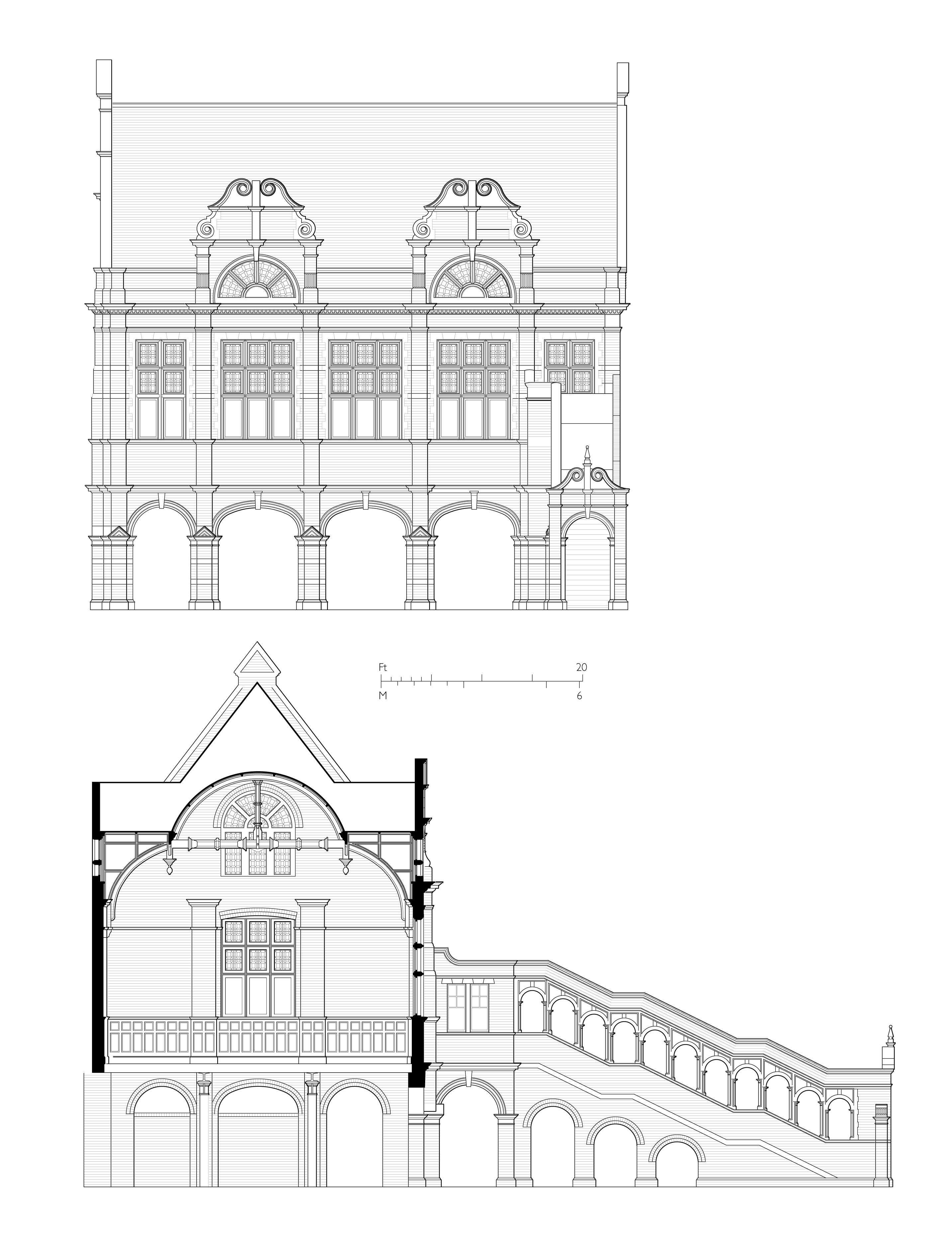
"file": "https://surveyoflondon.org/media/uploads/features/457/SCHOOL%20section%20and%20elevation%20final.jpg",
"description": "drawings by Helen Jones based on Greater London Council record drawings of 1984",
"copyright": true,
"created": "2018-02-07"
},
{
"id": 240,
"title": "Altab Ali Park",
"author": {
"id": 36,
"username": "JuditFerencz"
},
"feature": {
"id": 297,
"type": "Feature",
"geometry": {
"type": "MultiPolygon",
"coordinates": [
[
[
[
-0.068579013646325,
51.515806570966184
],
[
-0.068603236589372,
51.51579314242831
],
[
-0.068627932264343,
51.51578224735277
],
[
-0.068654968080886,
51.51577953902627
],
[
-0.068682395518699,
51.51578437002237
],
[
-0.068705925916716,
51.51579002894806
],
[
-0.068726713830396,
51.51580349912936
],
[
-0.068739060046585,
51.51582658529491
],
[
-0.068732341766045,
51.51585134703015
],
[
-0.068717700191129,
51.515864899109616
],
[
-0.068579013646325,
51.515806570966184
]
]
]
]
},
"properties": {
"b_number": "",
"b_name": "Shaheed Minar",
"street": "Whitechapel Road",
"address": "Shaheed Minar, Altab Ali Park",
"feature_type": "WHITECHAPEL_BUILDING",
"count": 5,
"search_str": "Shaheed Minar"
},
"tags": [
"monument"
]
},
"file": "https://surveyoflondon.org/media/uploads/features/297/altabali2_w.jpg",
"description": "",
"copyright": true,
"created": "2016-08-15"
},
{
"id": 757,
"title": "North Tenter Street elevation of Michael's House, as built in 1988, photograph August 2017",
"author": {
"id": 27,
"username": "DerekKendall"
},
"feature": {
"id": 1446,
"type": "Feature",
"geometry": {
"type": "MultiPolygon",
"coordinates": [
[
[
[
-0.07213481269225,
51.51296291379039
],
[
-0.072355493685734,
51.51292927094217
],
[
-0.072478836917297,
51.513210484398066
],
[
-0.072284592132567,
51.51325980061351
],
[
-0.07213481269225,
51.51296291379039
]
]
]
]
},
"properties": {
"b_number": "10–12",
"b_name": "Wool + Tailor Building, 10–12 Alie Street",
"street": "Alie Street",
"address": "Wool + Tailor Building, 10–12 Alie Street",
"feature_type": "WHITECHAPEL_BUILDING",
"count": 2,
"search_str": "Wool + Tailor Building, 10–12 Alie Street"
},
"tags": []
},
"file": "https://surveyoflondon.org/media/uploads/features/1446/SoL%20Whitechapel%20101245.jpg",
"description": "",
"copyright": true,
"created": "2017-09-12"
},
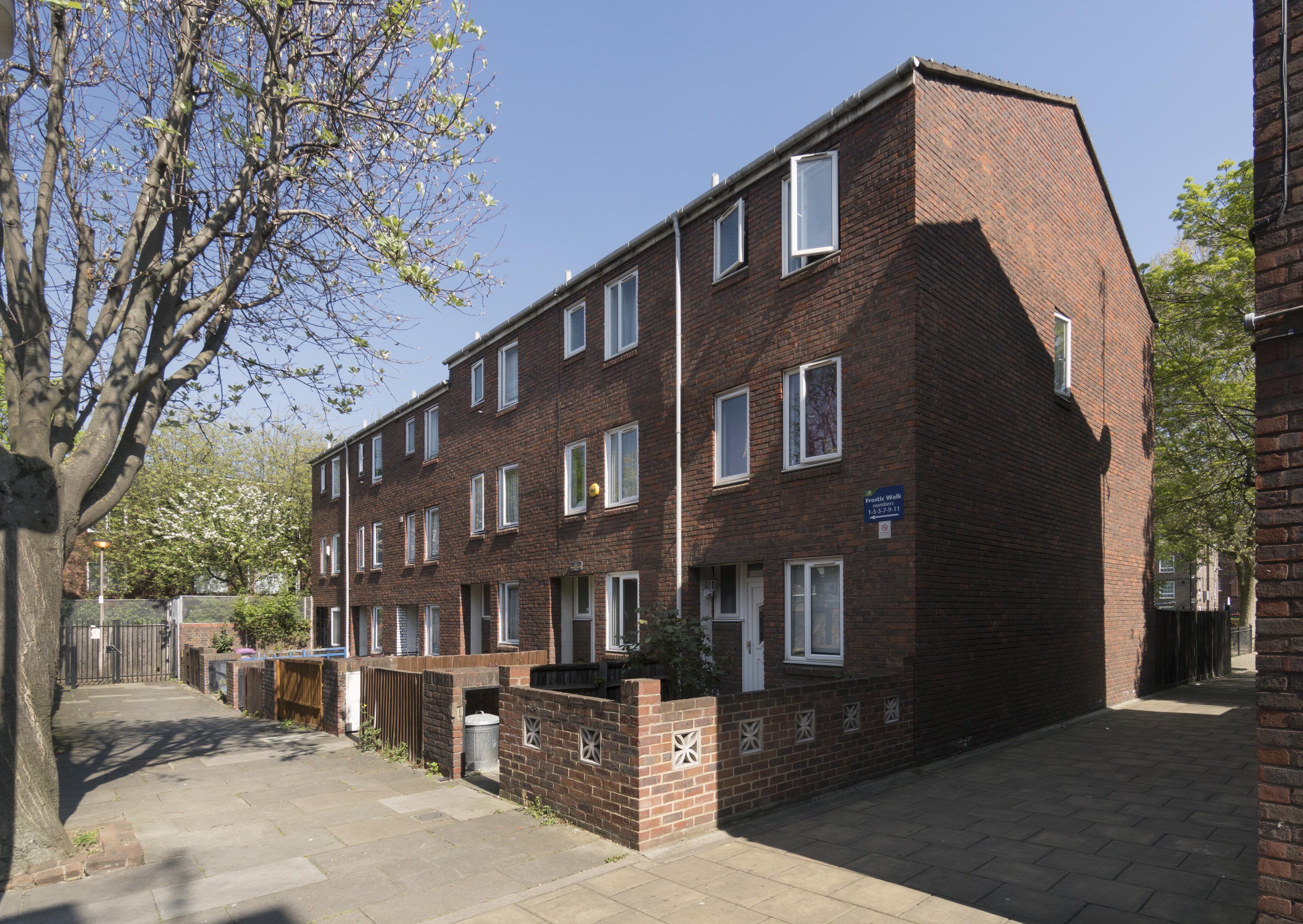
{
"id": 570,
"title": "Hopetown Estate - Frostic Walk from the south-west in April 2017",
"author": {
"id": 27,
"username": "DerekKendall"
},
"feature": {
"id": 232,
"type": "Feature",
"geometry": {
"type": "MultiPolygon",
"coordinates": [
[
[
[
-0.070109895820138,
51.51783967701595
],
[
-0.07025252335356,
51.51781094724582
],
[
-0.070252532169953,
51.51781094546991
],
[
-0.070270202694423,
51.51784717660232
],
[
-0.070270193880137,
51.51784717837781
],
[
-0.070127566142314,
51.517875907967344
],
[
-0.070109895820138,
51.51783967701595
]
]
]
]
},
"properties": {
"b_number": "10",
"b_name": "",
"street": "Frostic Walk",
"address": "10 Frostic Walk",
"feature_type": "WHITECHAPEL_BUILDING",
"count": 13,
"search_str": "10 Frostic Walk"
},
"tags": []
},
"file": "https://surveyoflondon.org/media/uploads/features/232/SoL%20Whitechapel%20100586.jpg",
"description": "",
"copyright": true,
"created": "2017-05-03"
},
{
"id": 252,
"title": "Whitechapel Methodist Mission, view from the south-east",
"author": {
"id": 31,
"username": "LucyMW"
},
"feature": {
"id": 1226,
"type": "Feature",
"geometry": {
"type": "MultiPolygon",
"coordinates": [
[
[
[
-0.057781597348087,
51.51931934049726
],
[
-0.057583510279063,
51.51936335562525
],
[
-0.057331742954463,
51.51892343874043
],
[
-0.057405984242291,
51.51890625776504
],
[
-0.057417150978354,
51.51892380850925
],
[
-0.057464414646317,
51.51891346295509
],
[
-0.057455443085981,
51.51889505673813
],
[
-0.057530567994777,
51.518878391257324
],
[
-0.057781597348087,
51.51931934049726
]
]
]
]
},
"properties": {
"b_number": "208-212",
"b_name": "Whitechapel Mission",
"street": "Whitechapel Road",
"address": "Whitechapel Mission",
"feature_type": "WHITECHAPEL_BUILDING",
"count": 5,
"search_str": "Whitechapel Mission"
},
"tags": [
"Whitechapel Mission"
]
},
"file": "https://surveyoflondon.org/media/uploads/features/1226/DP164500%20-%20Whitechapel%20Methodist%20Mission%2C%20208-212%20Whitechapel%20Road%20.jpg",
"description": "Whitechapel Methodist Mission, built to designs by Lee Reading & Associates c.1971. Photographed by Lucy Millson-Watkins in 2015. ",
"copyright": true,
"created": "2016-08-17"
},
{
"id": 535,
"title": "Great Garden Street Synagogue's interior in 1991, view from the north-east",
"author": {
"id": 37,
"username": "HistoricEngland"
},
"feature": {
"id": 282,
"type": "Feature",
"geometry": {
"type": "MultiPolygon",
"coordinates": [
[
[
[
-0.067166439426153,
51.517710385822326
],
[
-0.067530245010778,
51.51757758341182
],
[
-0.067664513450046,
51.517722482210196
],
[
-0.06729665215752,
51.517848524184735
],
[
-0.067166439426153,
51.517710385822326
]
]
]
]
},
"properties": {
"b_number": "7-11",
"b_name": "Business Development Centre, formerly Great Garden Street Synagogue and Morris Lederman House",
"street": "Greatorex Street",
"address": "7-11 Greatorex Street",
"feature_type": "WHITECHAPEL_BUILDING",
"count": 10,
"search_str": "Business Development Centre, formerly Great Garden Street Synagogue and Morris Lederman House"
},
"tags": [
"Federation of Synagogues",
"foundry",
"Morris Lederman",
"synagogue"
]
},
"file": "https://surveyoflondon.org/media/uploads/features/282/EPSON013.JPG",
"description": "",
"copyright": true,
"created": "2017-04-07"
},
{
"id": 536,
"title": "Great Garden Street Synagogue's interior in 1991, view from the gallery from the south-east",
"author": {
"id": 37,
"username": "HistoricEngland"
},
"feature": {
"id": 282,
"type": "Feature",
"geometry": {
"type": "MultiPolygon",
"coordinates": [
[
[
[
-0.067166439426153,
51.517710385822326
],
[
-0.067530245010778,
51.51757758341182
],
[
-0.067664513450046,
51.517722482210196
],
[
-0.06729665215752,
51.517848524184735
],
[
-0.067166439426153,
51.517710385822326
]
]
]
]
},
"properties": {
"b_number": "7-11",
"b_name": "Business Development Centre, formerly Great Garden Street Synagogue and Morris Lederman House",
"street": "Greatorex Street",
"address": "7-11 Greatorex Street",
"feature_type": "WHITECHAPEL_BUILDING",
"count": 10,
"search_str": "Business Development Centre, formerly Great Garden Street Synagogue and Morris Lederman House"
},
"tags": [
"Federation of Synagogues",
"foundry",
"Morris Lederman",
"synagogue"
]
},
"file": "https://surveyoflondon.org/media/uploads/features/282/EPSON014.JPG",
"description": "",
"copyright": true,
"created": "2017-04-07"
},
{
"id": 537,
"title": "Great Garden Street Synagogue in 1991, tablets and window above the head of the Ark",
"author": {
"id": 37,
"username": "HistoricEngland"
},
"feature": {
"id": 282,
"type": "Feature",
"geometry": {
"type": "MultiPolygon",
"coordinates": [
[
[
[
-0.067166439426153,
51.517710385822326
],
[
-0.067530245010778,
51.51757758341182
],
[
-0.067664513450046,
51.517722482210196
],
[
-0.06729665215752,
51.517848524184735
],
[
-0.067166439426153,
51.517710385822326
]
]
]
]
},
"properties": {
"b_number": "7-11",
"b_name": "Business Development Centre, formerly Great Garden Street Synagogue and Morris Lederman House",
"street": "Greatorex Street",
"address": "7-11 Greatorex Street",
"feature_type": "WHITECHAPEL_BUILDING",
"count": 10,
"search_str": "Business Development Centre, formerly Great Garden Street Synagogue and Morris Lederman House"
},
"tags": [
"Federation of Synagogues",
"foundry",
"Morris Lederman",
"synagogue"
]
},
"file": "https://surveyoflondon.org/media/uploads/features/282/EPSON015.JPG",
"description": "",
"copyright": true,
"created": "2017-04-07"
},
{
"id": 569,
"title": "7-11 Greatorex Street in April 2017",
"author": {
"id": 27,
"username": "DerekKendall"
},
"feature": {
"id": 282,
"type": "Feature",
"geometry": {
"type": "MultiPolygon",
"coordinates": [
[
[
[
-0.067166439426153,
51.517710385822326
],
[
-0.067530245010778,
51.51757758341182
],
[
-0.067664513450046,
51.517722482210196
],
[
-0.06729665215752,
51.517848524184735
],
[
-0.067166439426153,
51.517710385822326
]
]
]
]
},
"properties": {
"b_number": "7-11",
"b_name": "Business Development Centre, formerly Great Garden Street Synagogue and Morris Lederman House",
"street": "Greatorex Street",
"address": "7-11 Greatorex Street",
"feature_type": "WHITECHAPEL_BUILDING",
"count": 10,
"search_str": "Business Development Centre, formerly Great Garden Street Synagogue and Morris Lederman House"
},
"tags": [
"Federation of Synagogues",
"foundry",
"Morris Lederman",
"synagogue"
]
},
"file": "https://surveyoflondon.org/media/uploads/features/282/SoL%20Whitechapel%20100569.jpg",
"description": "",
"copyright": true,
"created": "2017-05-03"
},
{
"id": 579,
"title": "25 Casson Street, detail from doorway, April 2017",
"author": {
"id": 27,
"username": "DerekKendall"
},
"feature": {
"id": 207,
"type": "Feature",
"geometry": {
"type": "MultiPolygon",
"coordinates": [
[
[
[
-0.068511251129045,
51.518558315298705
],
[
-0.068422639446717,
51.518574845675246
],
[
-0.068404122260305,
51.51852885293329
],
[
-0.068490890137381,
51.51851352977218
],
[
-0.068490903705184,
51.51851353263917
],
[
-0.068490901372722,
51.51851353300471
],
[
-0.068511251129045,
51.518558315298705
]
]
]
]
},
"properties": {
"b_number": "25",
"b_name": "",
"street": "Casson Street",
"address": "25 Casson Street",
"feature_type": "WHITECHAPEL_BUILDING",
"count": 10,
"search_str": "25 Casson Street"
},
"tags": []
},
"file": "https://surveyoflondon.org/media/uploads/features/207/SoL%20Whitechapel%20100601.jpg",
"description": "",
"copyright": true,
"created": "2017-05-03"
},
{
"id": 466,
"title": "Rhythm Factory, c. 2013",
"author": {
"id": 29,
"username": "CRedgrave"
},
"feature": {
"id": 149,
"type": "Feature",
"geometry": {
"type": "MultiPolygon",
"coordinates": [
[
[
[
-0.067726383185714,
51.51676597696389
],
[
-0.067616472230646,
51.51681719642325
],
[
-0.067537624268648,
51.51675134445248
],
[
-0.067408192671059,
51.51663746794185
],
[
-0.067521967443561,
51.51658948754757
],
[
-0.067726383185714,
51.51676597696389
]
]
]
]
},
"properties": {
"b_number": "16-18",
"b_name": "",
"street": "Whitechapel Road",
"address": "16-18 Whitechapel Road",
"feature_type": "WHITECHAPEL_BUILDING",
"count": 3,
"search_str": "16-18 Whitechapel Road"
},
"tags": [
"Buck & Hickman",
"Killby & Gayford Ltd",
"Rhythm Factory"
]
},
"file": "https://surveyoflondon.org/media/uploads/features/149/The%20Rhythym%20Factory%202013.%20Chris%20R%20%20(1).jpg",
"description": "",
"copyright": false,
"created": "2016-12-15"
}
]
}
%20b+w.jpg)
.jpg)