HTTP 200 OK
Allow: GET, HEAD, OPTIONS
Content-Type: application/json
Vary: Accept
{
"count": 1747,
"next": "https://surveyoflondon.org/api/v1/images/?format=api&page=87",
"previous": "https://surveyoflondon.org/api/v1/images/?format=api&page=85",
"results": [
{
"id": 1373,
"title": "My parents' shop, W. Richardson & Sons Ltd",
"author": {
"id": 251,
"username": "Alicia"
},
"feature": {
"id": 453,
"type": "Feature",
"geometry": {
"type": "MultiPolygon",
"coordinates": [
[
[
[
-0.06387175509906,
51.51844488660313
],
[
-0.063674757657848,
51.51849920648765
],
[
-0.063594819394982,
51.5183863647881
],
[
-0.063789009522268,
51.51833442643744
],
[
-0.06387175509906,
51.51844488660313
]
]
]
]
},
"properties": {
"b_number": "183-185",
"b_name": "Former Jagonari Women's Centre, 183-185 Whitechapel Road",
"street": "Whitechapel Road",
"address": "183-185 Whitechapel Road",
"feature_type": "WHITECHAPEL_BUILDING",
"count": 15,
"search_str": "Former Jagonari Women's Centre, 183-185 Whitechapel Road"
},
"tags": [
"GLC",
"Jagonari",
"Matrix",
"nursery"
]
},
"file": "https://surveyoflondon.org/media/uploads/features/453/my%20parents%20outside%20183%20Whitechapel%20Road.JPG",
"description": "This shop is 183 Whitechapel Road. The business was owned by my parents from around 1930 until 1970. Originally there was a shop on the opposite side of the road which was bombed in WW2 so the business then moved to 183. As you will see from the photo it was an ironmongery (hardware) shop selling everything from paraffin to tin baths. As a child a knew Whitechapel well as I would go with my sister and parents every weekend and school holidays to the shop. My parents name was Manowitz but my father chose to keep the name Richardson which the business was named when he purchased it. The shop was tiny but full of nails, screws, scissors etc. They even sold tinned food at one time! My parents knew everybody around from the poet Abraham Stencl to many surgeons from the London Hospital. I remember them all. My parents originally lived at no. 21 New Road and I have a photograph of this house also. They lived a couple of doors away from the New Road Synagogue. My grandfather actually was a signwriter who created all the signs for the synagogue. He was a warden of the synagogue. The Hebrew lettering in the picture on this website of New Rd. Synagogue (now a factory), was written in gold by my grandfather Marks Manowitz.",
"copyright": false,
"created": "2018-10-27"
},
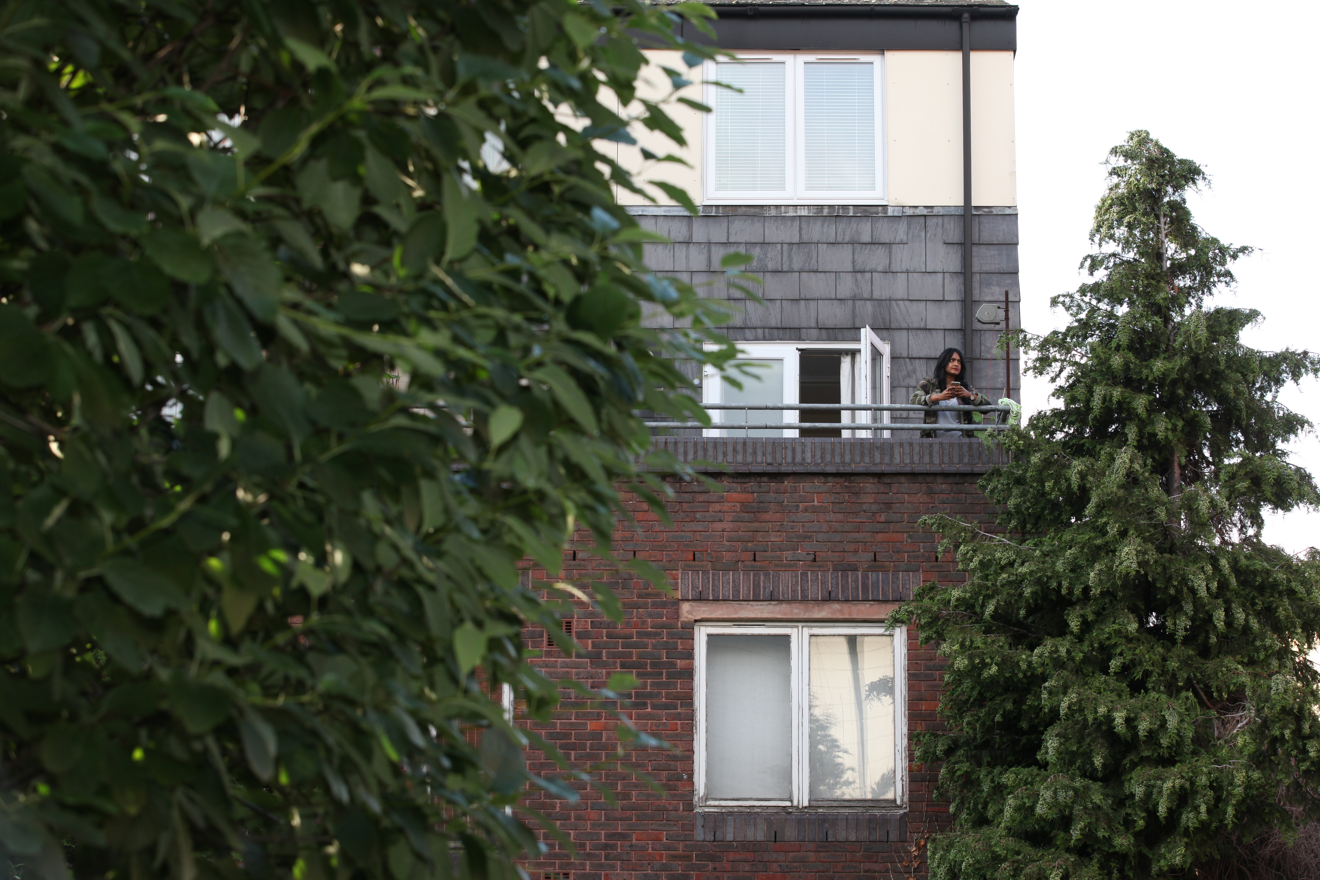
{
"id": 1789,
"title": "Royal Mint Estate in 2016, photograph by Rehan Jamil",
"author": {
"id": 184,
"username": "RehanJamil"
},
"feature": {
"id": 1711,
"type": "Feature",
"geometry": {
"type": "MultiPolygon",
"coordinates": [
[
[
[
-0.069855634822072,
51.50948205008636
],
[
-0.069760307108054,
51.50949979084116
],
[
-0.069711696262453,
51.50940000984055
],
[
-0.069803990781961,
51.5093825880565
],
[
-0.069836872616781,
51.509442152720766
],
[
-0.069855634822072,
51.50948205008636
]
]
]
]
},
"properties": {
"b_number": "",
"b_name": "",
"street": "",
"address": "Royal Mint Estate",
"feature_type": "WHITECHAPEL_BUILDING",
"count": 6,
"search_str": "Royal Mint Estate"
},
"tags": []
},
"file": "https://surveyoflondon.org/media/uploads/features/1711/IMG_7621%20-%20Sabira%20Rouf%2C%20Royal%20Mint%20Estate.jpg",
"description": "",
"copyright": true,
"created": "2020-10-12"
},
{
"id": 1788,
"title": "Roof terrace on the south pavilion at Mosque Tower in 2016, photograph by Rehan Jamil",
"author": {
"id": 184,
"username": "RehanJamil"
},
"feature": {
"id": 836,
"type": "Feature",
"geometry": {
"type": "MultiPolygon",
"coordinates": [
[
[
[
-0.066520816994333,
51.517246214877474
],
[
-0.066489969268877,
51.51724714356767
],
[
-0.066417224734998,
51.51714569570538
],
[
-0.066368964847431,
51.517083010694115
],
[
-0.066362088087024,
51.51703424412635
],
[
-0.066488148658609,
51.516997483363426
],
[
-0.066518515364924,
51.51703801832892
],
[
-0.066585424403568,
51.51701850677438
],
[
-0.066680604125336,
51.51714555656476
],
[
-0.066613143364286,
51.51716783085946
],
[
-0.066640795978102,
51.51720613428293
],
[
-0.066520816994333,
51.517246214877474
]
]
]
]
},
"properties": {
"b_number": "1",
"b_name": "",
"street": "Fieldgate Street",
"address": "Mosque Tower, 1 Fieldgate Street and 36 Whitechapel Road",
"feature_type": "WHITECHAPEL_BUILDING",
"count": 4,
"search_str": "Mosque Tower, 1 Fieldgate Street and 36 Whitechapel Road"
},
"tags": []
},
"file": "https://surveyoflondon.org/media/uploads/features/836/IMG_1103%20Mosque%20Tower%20-%20Anjali%20Chakrabarty.jpg",
"description": "",
"copyright": true,
"created": "2020-10-12"
},
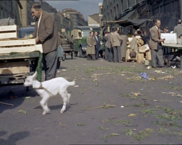
{
"id": 529,
"title": "Memories of A Kid for Two Farthings (1955) being filmed in Whitechapel",
"author": {
"id": 2,
"username": "surveyoflondon"
},
"feature": {
"id": 1742,
"type": "Feature",
"geometry": {
"type": "MultiPolygon",
"coordinates": [
[
[
[
-0.076387722492951,
51.516257872286374
],
[
-0.07580974439088,
51.51649846859169
],
[
-0.075744693982384,
51.51651411423466
],
[
-0.075332716624042,
51.51665341173461
],
[
-0.075277819023276,
51.516667372076085
],
[
-0.074429584483841,
51.51681699796736
],
[
-0.074402209988697,
51.516763242480046
],
[
-0.075229889371391,
51.51661092868018
],
[
-0.074836715281391,
51.516135055700595
],
[
-0.074917049606191,
51.51611135328064
],
[
-0.075312012611936,
51.51658616747119
],
[
-0.075695505281233,
51.51646463519818
],
[
-0.075779072585588,
51.51644696856364
],
[
-0.076328753388395,
51.516209038390684
],
[
-0.076387722492951,
51.516257872286374
]
]
]
]
},
"properties": {
"b_number": "",
"b_name": "",
"street": "",
"address": "Petticoat Lane Market",
"feature_type": "PLACE",
"count": 39,
"search_str": "Petticoat Lane Market"
},
"tags": []
},
"file": "https://surveyoflondon.org/media/uploads/features/1742/vlcsnap-2016-11-27-22h02m26s395.png",
"description": "Carol Fisher (74) recalls the filming in Wentworth Street of the film A Kid for Two Farthings (1955):\n\n\"I vividly remember A Kid for Two Farthings being made in the lane. Directed by Sir Carol Reed and starred Jo Robinson. I remember because my grandmother, Becky Elboz, invited them into her flat in Wentworth Dwellings for a cup of tea. Some came, including Jo Robinson. I watched them film the old man with the wheelbarrow and also watched them fit a horn onto a white goat to make it a unicorn. I lived in Wentworth Dwellings. Number 35. My grandmother lived at number 31 and my mothers sister and her family lived at number 30.\"\n",
"copyright": false,
"created": "2017-03-22"
},
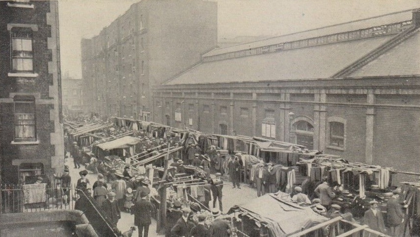
{
"id": 418,
"title": "Goulston Street swimming baths, c. 1910",
"author": {
"id": 25,
"username": "Aileen"
},
"feature": {
"id": 352,
"type": "Feature",
"geometry": {
"type": "MultiPolygon",
"coordinates": [
[
[
[
-0.074054080597776,
51.51555514765241
],
[
-0.074054115992124,
51.515554308575716
],
[
-0.07414978140901,
51.515521768515015
],
[
-0.07414978302715,
51.51552176080992
],
[
-0.07414979264086,
51.51552177174922
],
[
-0.074215900409984,
51.51549915533648
],
[
-0.074292739580167,
51.51558658878088
],
[
-0.074321847397495,
51.51557663055657
],
[
-0.074758297356278,
51.51611372084429
],
[
-0.074571520152739,
51.51617247596233
],
[
-0.07429542906329,
51.515849759837266
],
[
-0.074259162582118,
51.51585812719654
],
[
-0.074152358267357,
51.5157385972648
],
[
-0.074077379540267,
51.51565328066505
],
[
-0.074126373340093,
51.515636519281486
],
[
-0.074054681201403,
51.5155549421787
],
[
-0.074054080597776,
51.51555514765241
]
]
]
]
},
"properties": {
"b_number": "16",
"b_name": "former London Metropolitan University law and business school",
"street": "Goulston Street",
"address": "former London Metropolitan University Dept of Law and Business",
"feature_type": "WHITECHAPEL_BUILDING",
"count": 4,
"search_str": "former London Metropolitan University law and business school"
},
"tags": []
},
"file": "https://surveyoflondon.org/media/uploads/features/352/Goulston%20Street%20cloth%20market%20cropped_xkJQszE.jpg",
"description": "Photograph from a postcard showing Petticoat Lane market stalls in Goulston Street with the swimming bath on the right (east side), 90-143 Wentworth Dwellings beyond, and part of Brunswick Buildings on the left",
"copyright": false,
"created": "2016-10-06"
},
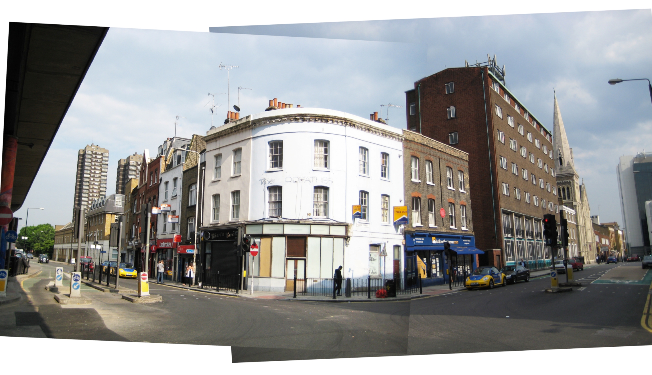
{
"id": 1792,
"title": "Panorama of corner of Cable Street and Dock Street in 2008",
"author": {
"id": 153,
"username": "danny"
},
"feature": {
"id": 1368,
"type": "Feature",
"geometry": {
"type": "MultiPolygon",
"coordinates": [
[
[
[
-0.068304836027203,
51.51073531158041
],
[
-0.068280626941554,
51.51066731775845
],
[
-0.068273645510051,
51.51064349252156
],
[
-0.068344140610016,
51.51063057393707
],
[
-0.068360428462064,
51.51067502754345
],
[
-0.068363636587595,
51.51068728948646
],
[
-0.068362263104961,
51.510697731803
],
[
-0.068356160539397,
51.5107098403773
],
[
-0.068349825933683,
51.51071642196578
],
[
-0.068338811399467,
51.5107235078495
],
[
-0.068328323844215,
51.5107291489489
],
[
-0.068318877871198,
51.510733223642234
],
[
-0.068304836027203,
51.51073531158041
]
]
]
]
},
"properties": {
"b_number": "1",
"b_name": "",
"street": "Dock Street",
"address": "1 Dock Street",
"feature_type": "WHITECHAPEL_BUILDING",
"count": 8,
"search_str": "1 Dock Street"
},
"tags": []
},
"file": "https://surveyoflondon.org/media/uploads/features/1368/2%20Cable%201%20Dock%20panorama%20v3.jpg",
"description": "A panorama created from images taken in 2008 showing the buildings at the corner of Cable Street and Dock Street, E1. Originally a cafe, the corner building became a fish and chip shop named the Codfather which did not seem to be that successful and was later taken over by Estate Agents. The former seamen's hostel the Red Ensign Club, by this time renamed Beacon House can be seen on Dock Street. These premises were used to house homeless tenants and had a very significant and ultimately detrimental impact on levels of drug dealing and anti-social behaviour in the local area which has only begun to run down by 2020. That building became the Wombat Hostel for backpackers in 2016.",
"copyright": false,
"created": "2021-01-24"
},
{
"id": 1794,
"title": "New Holland Estate in 2010 and 2015 - drawing by Helen Jones",
"author": {
"id": 2,
"username": "surveyoflondon"
},
"feature": {
"id": 1454,
"type": "Feature",
"geometry": {
"type": "MultiPolygon",
"coordinates": [
[
[
[
-0.073448547413177,
51.516379700226935
],
[
-0.073336799805522,
51.51624409264526
],
[
-0.07309813858896,
51.51632069440908
],
[
-0.073209924770563,
51.51645628282147
],
[
-0.073448547413177,
51.516379700226935
]
]
]
]
},
"properties": {
"b_number": "33",
"b_name": "Denning Point",
"street": "Commercial Street",
"address": "Denning Point, 33 Commercial Street, London",
"feature_type": "WHITECHAPEL_BUILDING",
"count": 5,
"search_str": "Denning Point"
},
"tags": []
},
"file": "https://surveyoflondon.org/media/uploads/features/1454/new%20holland%20estate%20FINAL%201-2.jpg",
"description": "",
"copyright": true,
"created": "2021-02-10"
},
{
"id": 1795,
"title": "Boys' Refuge, plan in 1854 - drawing by Helen Jones",
"author": {
"id": 2,
"username": "surveyoflondon"
},
"feature": {
"id": 379,
"type": "Feature",
"geometry": {
"type": "MultiPolygon",
"coordinates": [
[
[
[
-0.072397829403071,
51.51669736298538
],
[
-0.072397829775652,
51.51669737370259
],
[
-0.072432640663459,
51.51673265247548
],
[
-0.072358283763003,
51.51675511998594
],
[
-0.072392345089312,
51.51679900052574
],
[
-0.072279169019407,
51.51681120129116
],
[
-0.072260832658385,
51.516791637982884
],
[
-0.07220017871295,
51.51681376750612
],
[
-0.07215893969634,
51.516769768915125
],
[
-0.072119241451839,
51.51677664825232
],
[
-0.071934651446851,
51.5165549241745
],
[
-0.071985260710591,
51.51653955484268
],
[
-0.072028895096668,
51.51652682786407
],
[
-0.072014842692988,
51.516508073517755
],
[
-0.072098254454469,
51.51648373796318
],
[
-0.072052675375786,
51.51643004607134
],
[
-0.072144607110911,
51.516401673048335
],
[
-0.072314904588685,
51.51634652520951
],
[
-0.072358068161013,
51.516398410711595
],
[
-0.072522445522427,
51.51634491903885
],
[
-0.072499976579174,
51.51631804154615
],
[
-0.072499959446261,
51.51631804712155
],
[
-0.072499965346341,
51.51631803831239
],
[
-0.072579515746657,
51.51629075531372
],
[
-0.072667639265209,
51.516403182536045
],
[
-0.072427304765486,
51.5164813923298
],
[
-0.072385415219988,
51.51643128370629
],
[
-0.072387162242999,
51.516433383744854
],
[
-0.072107982084202,
51.516523791132904
],
[
-0.072157544605501,
51.51658336890495
],
[
-0.072272128891629,
51.51654626302576
],
[
-0.072397829403071,
51.51669736298538
]
]
]
]
},
"properties": {
"b_number": "28 ",
"b_name": "Toynbee Hall",
"street": "Commercial Street",
"address": "Toynbee Hall, 28 Commercial Street",
"feature_type": "WHITECHAPEL_BUILDING",
"count": 21,
"search_str": "Toynbee Hall"
},
"tags": []
},
"file": "https://surveyoflondon.org/media/uploads/features/379/Toynbee%20Hall%201853.jpg",
"description": "",
"copyright": true,
"created": "2021-02-10"
},
{
"id": 1791,
"title": "Marine Engineer's Certificate ",
"author": {
"id": 321,
"username": "stephen2"
},
"feature": {
"id": 1370,
"type": "Feature",
"geometry": {
"type": "MultiPolygon",
"coordinates": [
[
[
[
-0.067783647338447,
51.51017527172947
],
[
-0.067575803709333,
51.51021492278667
],
[
-0.067558594183028,
51.510218286467044
],
[
-0.067466520880171,
51.51002935056337
],
[
-0.06767269738543,
51.509992670709266
],
[
-0.067723633842387,
51.510108640950456
],
[
-0.067752148490552,
51.510104986424565
],
[
-0.067783647338447,
51.51017527172947
]
]
]
]
},
"properties": {
"b_number": "18",
"b_name": "",
"street": "Ensign Street",
"address": "18 Ensign Street",
"feature_type": "WHITECHAPEL_BUILDING",
"count": 8,
"search_str": "18 Ensign Street"
},
"tags": [
"Board of Trade",
"John Hudson",
"merchant navy",
"Walter Gladding"
]
},
"file": "https://surveyoflondon.org/media/uploads/features/1370/S.J.%20Arnold%20Marine%20Engineers%20Certificate%201981%20Stamped%2018%20Ensign%20St_dtBNXX2.PNG",
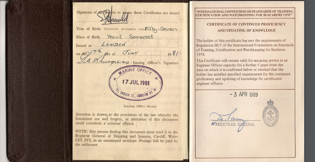
"description": "Reward for many years of study and sea service.\n1982: Dept of Transport Certificate of Competency for Marine Engineering Officers (Motor). Certificate No. 8080 awarded after attending Poplar School of marine engineering, Poplar High Street, for written exams after 18-month sea service and three months study period, then if successful, invited to attend 18 Ensign Street for oral exam to answer the examiners' questions on a one-to-one basis in such a way as to demonstrate sufficient knowledge of marine engineering to pass and be awarded my certificate.\nAn imposing structure when walking up to the entrance that was a defining gate to transit in developing one's destiny.\n\n\n",
"copyright": true,
"created": "2020-11-30"
},
{
"id": 1790,
"title": "Bakers Arms Alley - Map",
"author": {
"id": 301,
"username": "oneillflynn"
},
"feature": {
"id": 1310,
"type": "Feature",
"geometry": {
"type": "MultiPolygon",
"coordinates": [
[
[
[
-0.072640543386628,
51.511126910908146
],
[
-0.072546284627394,
51.51109445750477
],
[
-0.072442870594844,
51.51105766937985
],
[
-0.072212891852196,
51.511015291752464
],
[
-0.071794996225884,
51.51092420910208
],
[
-0.072193476308503,
51.510898011530344
],
[
-0.072292806128645,
51.51091522504932
],
[
-0.072304530237151,
51.510931416638016
],
[
-0.07242778419924,
51.51096443737364
],
[
-0.072431087286307,
51.51095279556461
],
[
-0.072461272416322,
51.51095734673215
],
[
-0.072466091619938,
51.51096214778542
],
[
-0.072488635517089,
51.510966022410706
],
[
-0.072644665703862,
51.511088472040846
],
[
-0.072640543386628,
51.511126910908146
]
]
]
]
},
"properties": {
"b_number": "",
"b_name": "Railway Viaduct Spur",
"street": "Mansell Street / Chamber Street",
"address": "Railway Viaduct Spur, Mansell Street / Chamber Street",
"feature_type": "WHITECHAPEL_BUILDING",
"count": 17,
"search_str": "Railway Viaduct Spur"
},
"tags": []
},
"file": "https://surveyoflondon.org/media/uploads/features/1310/1746%20Roche%20Map%20-%20Bakers%20arms%20alley_Location.jpg",
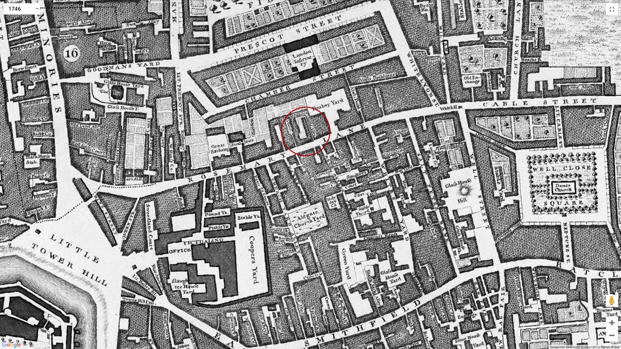
"description": "Image of the 1746 Rocque Map showing environs around the north of Rosemary Lane. Later renamed as Royal Mint Street from 1850. The area between Royal Mint Street and Chamber Street was subsequently redeveloped as part of slum clearances to include railway goodsyards for The London and Blackwall Railway. \n\nThis particular map specifically identifies Baker Arms Alley which is rare due to later maps tending to block in areas of slum housing and predominantly show major thoroughfares only\n\nBakers Arms Alley is of particular interest as research through both family history and supported through the 1841 and 1851 Census shows the area as being a heavily populated destination of Irish immigrants originating from Cork City and the larger Cork County.",
"copyright": false,
"created": "2020-10-20"
},
{
"id": 1796,
"title": "Toynbee Hall, plan in 1885 - drawing by Helen Jones",
"author": {
"id": 2,
"username": "surveyoflondon"
},
"feature": {
"id": 379,
"type": "Feature",
"geometry": {
"type": "MultiPolygon",
"coordinates": [
[
[
[
-0.072397829403071,
51.51669736298538
],
[
-0.072397829775652,
51.51669737370259
],
[
-0.072432640663459,
51.51673265247548
],
[
-0.072358283763003,
51.51675511998594
],
[
-0.072392345089312,
51.51679900052574
],
[
-0.072279169019407,
51.51681120129116
],
[
-0.072260832658385,
51.516791637982884
],
[
-0.07220017871295,
51.51681376750612
],
[
-0.07215893969634,
51.516769768915125
],
[
-0.072119241451839,
51.51677664825232
],
[
-0.071934651446851,
51.5165549241745
],
[
-0.071985260710591,
51.51653955484268
],
[
-0.072028895096668,
51.51652682786407
],
[
-0.072014842692988,
51.516508073517755
],
[
-0.072098254454469,
51.51648373796318
],
[
-0.072052675375786,
51.51643004607134
],
[
-0.072144607110911,
51.516401673048335
],
[
-0.072314904588685,
51.51634652520951
],
[
-0.072358068161013,
51.516398410711595
],
[
-0.072522445522427,
51.51634491903885
],
[
-0.072499976579174,
51.51631804154615
],
[
-0.072499959446261,
51.51631804712155
],
[
-0.072499965346341,
51.51631803831239
],
[
-0.072579515746657,
51.51629075531372
],
[
-0.072667639265209,
51.516403182536045
],
[
-0.072427304765486,
51.5164813923298
],
[
-0.072385415219988,
51.51643128370629
],
[
-0.072387162242999,
51.516433383744854
],
[
-0.072107982084202,
51.516523791132904
],
[
-0.072157544605501,
51.51658336890495
],
[
-0.072272128891629,
51.51654626302576
],
[
-0.072397829403071,
51.51669736298538
]
]
]
]
},
"properties": {
"b_number": "28 ",
"b_name": "Toynbee Hall",
"street": "Commercial Street",
"address": "Toynbee Hall, 28 Commercial Street",
"feature_type": "WHITECHAPEL_BUILDING",
"count": 21,
"search_str": "Toynbee Hall"
},
"tags": []
},
"file": "https://surveyoflondon.org/media/uploads/features/379/Toynbee%20Hall%201885.jpg",
"description": "",
"copyright": true,
"created": "2021-02-10"
},
{
"id": 1703,
"title": "Rear of 24 Prescot Street",
"author": {
"id": 153,
"username": "danny"
},
"feature": {
"id": 1295,
"type": "Feature",
"geometry": {
"type": "MultiPolygon",
"coordinates": [
[
[
[
-0.071706015667423,
51.51096836077219
],
[
-0.071760673580627,
51.511094407858565
],
[
-0.071694522326586,
51.511107355424194
],
[
-0.071723514638995,
51.51117537716788
],
[
-0.071731537079554,
51.51117404707196
],
[
-0.071738018293242,
51.511187019360314
],
[
-0.071730451789257,
51.511188649356484
],
[
-0.07175065859756,
51.51124278370494
],
[
-0.071880742816297,
51.51122503927087
],
[
-0.071935648282288,
51.51134524228436
],
[
-0.07160179754467,
51.51139998766625
],
[
-0.071526476862373,
51.51122506187527
],
[
-0.071516150035805,
51.511225476853056
],
[
-0.071512034959162,
51.511211958658905
],
[
-0.071521499273981,
51.51120977508156
],
[
-0.07149261831904,
51.51113912349431
],
[
-0.071306734256067,
51.51116881548001
],
[
-0.071247789729444,
51.511033340787506
],
[
-0.071706015667423,
51.51096836077219
]
]
]
]
},
"properties": {
"b_number": "24",
"b_name": "",
"street": "Prescot Street",
"address": "Premier Inn, 24 Prescot Street",
"feature_type": "WHITECHAPEL_BUILDING",
"count": 7,
"search_str": "Premier Inn, 24 Prescot Street"
},
"tags": []
},
"file": "https://surveyoflondon.org/media/uploads/features/1295/Rear%20of%20Convent%2024%20Prescot%20Street.jpg",
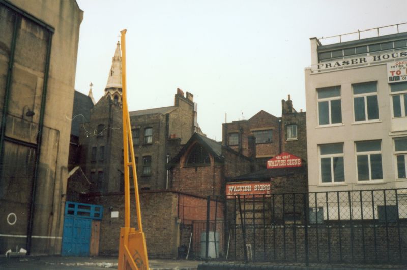
"description": "This is a photograph taken in Chamber Street circa 1985 showing the rear of the Holy Family Sisters' convent at 24 Prescot Street. The convent chapel can be clearly seen in the centre of the picture. To the left is the rear of the former Presbytery of English Martyrs Church whose spire can also be seen in the picture.\n\nThe building to the right housed Walvish Signs and a white building called Fraser House can be seen too. This was situated in Yeoman's Yard, a small cul-de-sac off Chamber Street.\n\nIn the foreground, the yellow gate is situated on the former playground of Tower Hill School and the former school buildings, later the English Martyrs Comunity Centre can be seen with green supporting girders. The blue fence with gate was the entrance to the school from the playground. I attended this school from 1964 until it moved to the new premises in St Mark Street and became English Martyrs School in September 1969.",
"copyright": false,
"created": "2020-05-12"
},
{
"id": 1801,
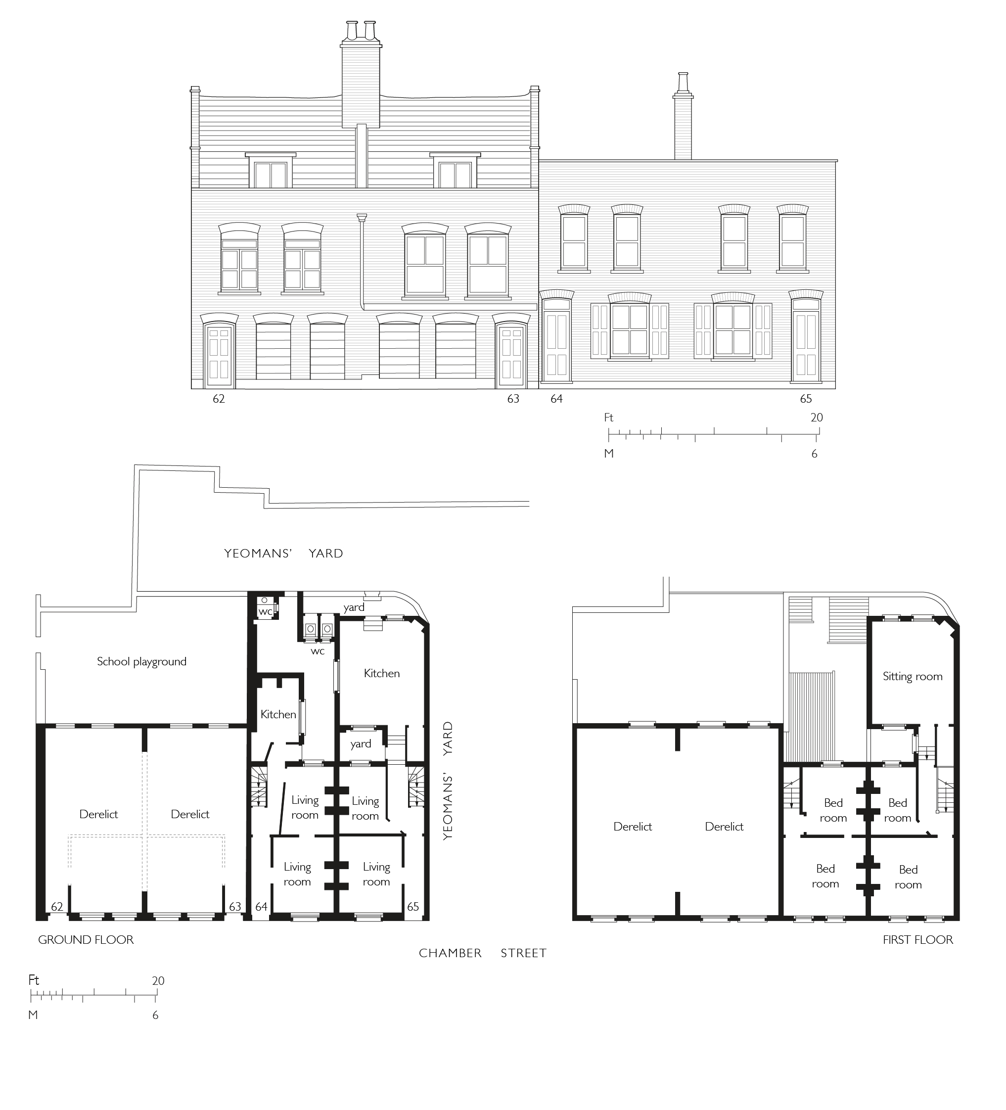
"title": "62–65 Chamber Street in 1934 - drawing by Helen Jones",
"author": {
"id": 2,
"username": "surveyoflondon"
},
"feature": {
"id": 1295,
"type": "Feature",
"geometry": {
"type": "MultiPolygon",
"coordinates": [
[
[
[
-0.071706015667423,
51.51096836077219
],
[
-0.071760673580627,
51.511094407858565
],
[
-0.071694522326586,
51.511107355424194
],
[
-0.071723514638995,
51.51117537716788
],
[
-0.071731537079554,
51.51117404707196
],
[
-0.071738018293242,
51.511187019360314
],
[
-0.071730451789257,
51.511188649356484
],
[
-0.07175065859756,
51.51124278370494
],
[
-0.071880742816297,
51.51122503927087
],
[
-0.071935648282288,
51.51134524228436
],
[
-0.07160179754467,
51.51139998766625
],
[
-0.071526476862373,
51.51122506187527
],
[
-0.071516150035805,
51.511225476853056
],
[
-0.071512034959162,
51.511211958658905
],
[
-0.071521499273981,
51.51120977508156
],
[
-0.07149261831904,
51.51113912349431
],
[
-0.071306734256067,
51.51116881548001
],
[
-0.071247789729444,
51.511033340787506
],
[
-0.071706015667423,
51.51096836077219
]
]
]
]
},
"properties": {
"b_number": "24",
"b_name": "",
"street": "Prescot Street",
"address": "Premier Inn, 24 Prescot Street",
"feature_type": "WHITECHAPEL_BUILDING",
"count": 7,
"search_str": "Premier Inn, 24 Prescot Street"
},
"tags": []
},
"file": "https://surveyoflondon.org/media/uploads/features/1295/62-65%20Chamber%20Street%20plans%201%20c.jpg",
"description": "",
"copyright": true,
"created": "2021-02-11"
},
{
"id": 1803,
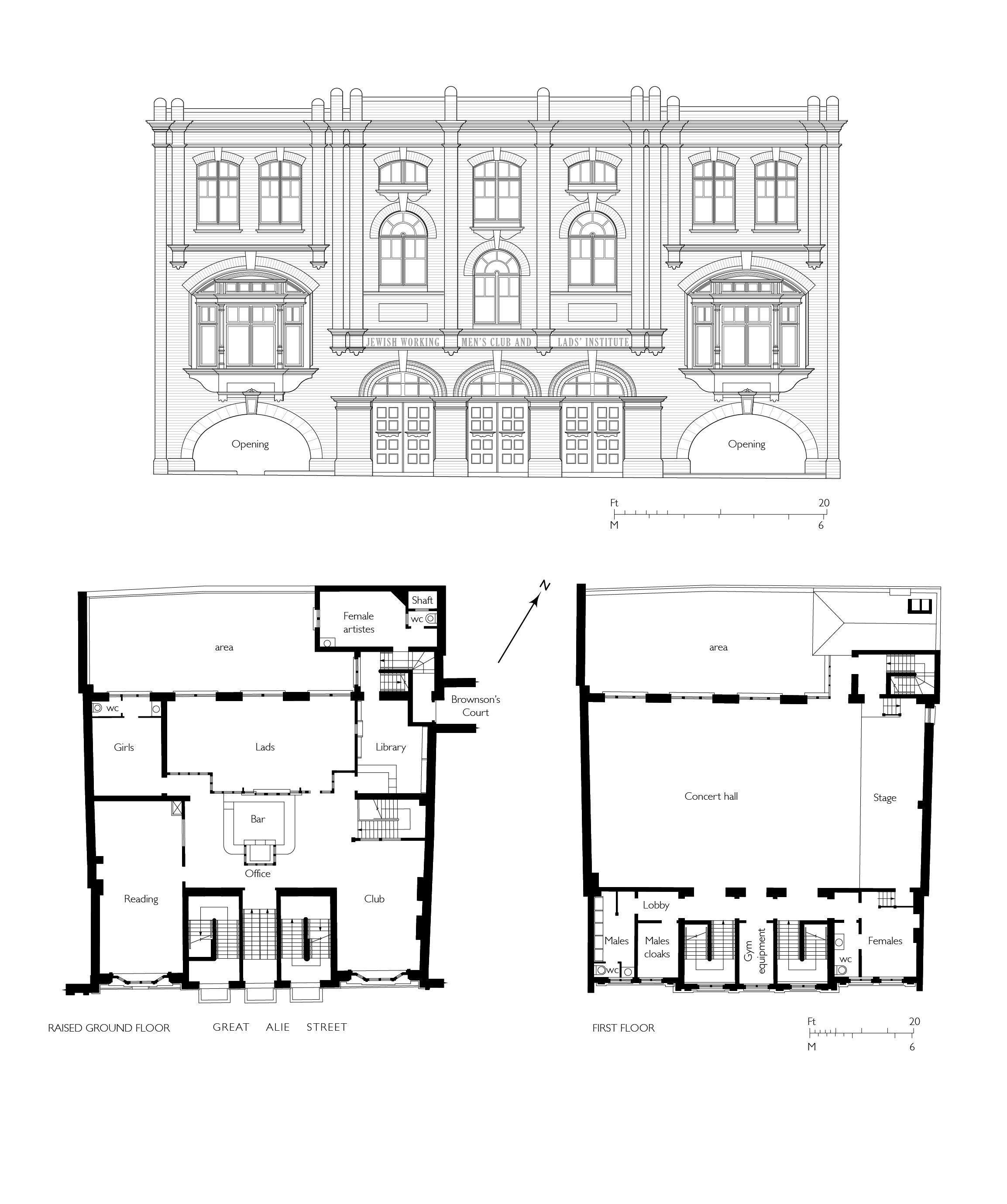
"title": "Jewish Working Men's Institute, c.1891, elevation and plans - drawing by Helen Jones",
"author": {
"id": 2,
"username": "surveyoflondon"
},
"feature": {
"id": 36,
"type": "Feature",
"geometry": {
"type": "MultiPolygon",
"coordinates": [
[
[
[
-0.071349046337364,
51.5138078614866
],
[
-0.071271119926767,
51.51383480345585
],
[
-0.071192934027189,
51.51374219365012
],
[
-0.071638175035756,
51.51359010289689
],
[
-0.071723422786149,
51.51368468893144
],
[
-0.071595104590834,
51.51372885698717
],
[
-0.071660988827371,
51.513800289480336
],
[
-0.071852439251352,
51.5137363635275
],
[
-0.071893659649719,
51.51377871138786
],
[
-0.071944898260579,
51.51376139378089
],
[
-0.071986149033662,
51.51381345244115
],
[
-0.071933998401112,
51.51382983458348
],
[
-0.071956084837385,
51.51385790340382
],
[
-0.071453670719252,
51.514037239610516
],
[
-0.071346445213241,
51.5139065028523
],
[
-0.07140854712421,
51.51388212034982
],
[
-0.071349046337364,
51.5138078614866
]
]
]
]
},
"properties": {
"b_number": "25",
"b_name": "Central House",
"street": "Camperdown Street",
"address": "25 Camperdown Street",
"feature_type": "WHITECHAPEL_BUILDING",
"count": 6,
"search_str": "Central House"
},
"tags": []
},
"file": "https://surveyoflondon.org/media/uploads/features/36/Jewish%20working%20mens%20institute%20combined%201.jpg",
"description": "",
"copyright": true,
"created": "2021-02-17"
},
{
"id": 1804,
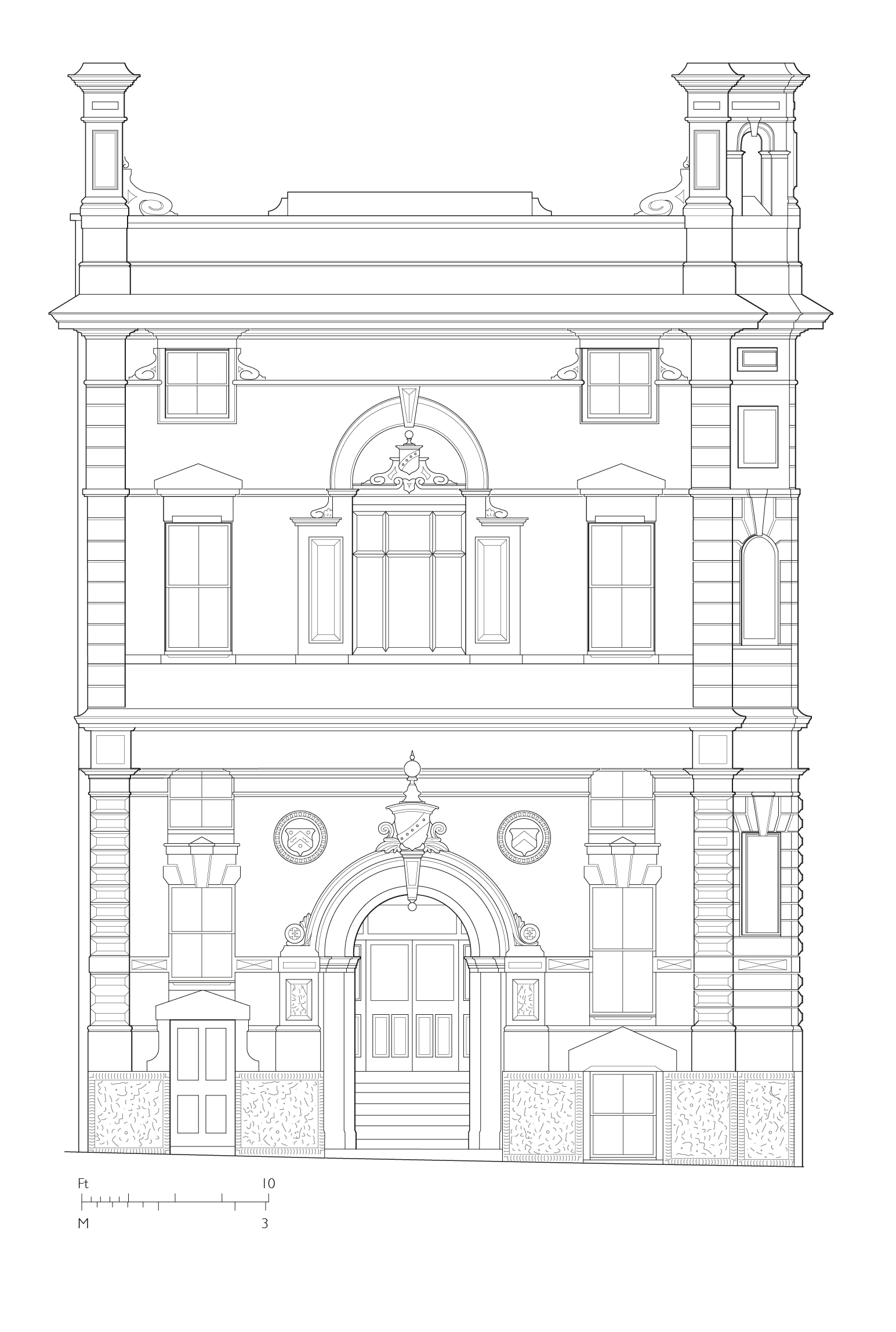
"title": "Whitechapel Foundation Commercial School, Buckle Street elevation as built in 1857 - drawing by Helen Jones",
"author": {
"id": 2,
"username": "surveyoflondon"
},
"feature": {
"id": 15,
"type": "Feature",
"geometry": {
"type": "MultiPolygon",
"coordinates": [
[
[
[
-0.07038859472598,
51.51426496387257
],
[
-0.07073271347526,
51.51412601920421
],
[
-0.070849739517874,
51.514247147044586
],
[
-0.070508832474584,
51.514384190759564
],
[
-0.07038859472598,
51.51426496387257
]
]
]
]
},
"properties": {
"b_number": "19",
"b_name": "City Reach, 19 Leman Street",
"street": "Leman Street",
"address": "City Reach, 19 Leman Street",
"feature_type": "WHITECHAPEL_BUILDING",
"count": 5,
"search_str": "City Reach, 19 Leman Street"
},
"tags": []
},
"file": "https://surveyoflondon.org/media/uploads/features/15/Buckle%20Street%20elevation%202b.jpg",
"description": "",
"copyright": true,
"created": "2021-02-17"
},
{
"id": 1805,
"title": "Dental Hospital and Institute of Dentistry, upper-storey plan as built - drawing by Helen Jones",
"author": {
"id": 2,
"username": "surveyoflondon"
},
"feature": {
"id": 1166,
"type": "Feature",
"geometry": {
"type": "MultiPolygon",
"coordinates": [
[
[
[
-0.062351470894244,
51.51718815629615
],
[
-0.061292929801261,
51.51728379235413
],
[
-0.061222794483401,
51.51696856036261
],
[
-0.062282192019856,
51.516876806223415
],
[
-0.062351470894244,
51.51718815629615
]
]
]
]
},
"properties": {
"b_number": "",
"b_name": "",
"street": "Stepney Way",
"address": "Dental Hospital and Institute of Dentistry",
"feature_type": "WHITECHAPEL_BUILDING",
"count": 13,
"search_str": "Dental Hospital and Institute of Dentistry"
},
"tags": [
"Dental Institute",
"London Hospital",
"Royal London Hospital",
"Stephen Statham & Associates",
"Students' Union"
]
},
"file": "https://surveyoflondon.org/media/uploads/features/1166/The%20dental%20hospital%20new%201.jpg",
"description": "",
"copyright": true,
"created": "2021-02-23"
},
{
"id": 1806,
"title": "Plans of demolished nurses' homes (Old Home and Alexandra Home) - drawing by Helen Jones",
"author": {
"id": 2,
"username": "surveyoflondon"
},
"feature": {
"id": 1055,
"type": "Feature",
"geometry": {
"type": "MultiPolygon",
"coordinates": [
[
[
[
-0.059603168139066,
51.51814636262423
],
[
-0.05875064513042,
51.51833756100746
],
[
-0.05880027021497,
51.518428132403216
],
[
-0.058410175950557,
51.51851717894338
],
[
-0.058335119342649,
51.518387426557936
],
[
-0.058167883621195,
51.51840165384316
],
[
-0.058022191519375,
51.51770291533161
],
[
-0.058048225832449,
51.51770082847909
],
[
-0.0579567547367,
51.51754022786524
],
[
-0.057495813231092,
51.51758034522329
],
[
-0.057465726563153,
51.517443962991116
],
[
-0.057673016552398,
51.517425768571606
],
[
-0.057646690264841,
51.51729977054202
],
[
-0.057699256976843,
51.517294411534294
],
[
-0.059206618543123,
51.51716361286622
],
[
-0.05935638144775,
51.51742122218897
],
[
-0.059104959322273,
51.51744251080535
],
[
-0.059176189888187,
51.51756734317978
],
[
-0.05939181053717,
51.51754735040721
],
[
-0.059446707065502,
51.517822454567046
],
[
-0.059415919392695,
51.51782446306142
],
[
-0.059603168139066,
51.51814636262423
]
]
]
]
},
"properties": {
"b_number": "",
"b_name": "",
"street": "Stepney Way",
"address": "The Royal London Hospital",
"feature_type": "WHITECHAPEL_BUILDING",
"count": 13,
"search_str": "The Royal London Hospital"
},
"tags": []
},
"file": "https://surveyoflondon.org/media/uploads/features/1055/Nurses%20Homes%201%20combined%202.jpg",
"description": "",
"copyright": true,
"created": "2021-02-23"
},
{
"id": 1807,
"title": "Plans of nurses' and doctors' housing (Edith Cavell Home, Resident Doctors' Hostel and Knutsford House) - drawing by Helen Jones",
"author": {
"id": 2,
"username": "surveyoflondon"
},
"feature": {
"id": 1055,
"type": "Feature",
"geometry": {
"type": "MultiPolygon",
"coordinates": [
[
[
[
-0.059603168139066,
51.51814636262423
],
[
-0.05875064513042,
51.51833756100746
],
[
-0.05880027021497,
51.518428132403216
],
[
-0.058410175950557,
51.51851717894338
],
[
-0.058335119342649,
51.518387426557936
],
[
-0.058167883621195,
51.51840165384316
],
[
-0.058022191519375,
51.51770291533161
],
[
-0.058048225832449,
51.51770082847909
],
[
-0.0579567547367,
51.51754022786524
],
[
-0.057495813231092,
51.51758034522329
],
[
-0.057465726563153,
51.517443962991116
],
[
-0.057673016552398,
51.517425768571606
],
[
-0.057646690264841,
51.51729977054202
],
[
-0.057699256976843,
51.517294411534294
],
[
-0.059206618543123,
51.51716361286622
],
[
-0.05935638144775,
51.51742122218897
],
[
-0.059104959322273,
51.51744251080535
],
[
-0.059176189888187,
51.51756734317978
],
[
-0.05939181053717,
51.51754735040721
],
[
-0.059446707065502,
51.517822454567046
],
[
-0.059415919392695,
51.51782446306142
],
[
-0.059603168139066,
51.51814636262423
]
]
]
]
},
"properties": {
"b_number": "",
"b_name": "",
"street": "Stepney Way",
"address": "The Royal London Hospital",
"feature_type": "WHITECHAPEL_BUILDING",
"count": 13,
"search_str": "The Royal London Hospital"
},
"tags": []
},
"file": "https://surveyoflondon.org/media/uploads/features/1055/Nurses%20Homes%202%20combined%202.jpg",
"description": "",
"copyright": true,
"created": "2021-02-23"
},
{
"id": 1812,
"title": "32–34 Commercial Road from the north-east in 2021",
"author": {
"id": 27,
"username": "DerekKendall"
},
"feature": {
"id": 989,
"type": "Feature",
"geometry": {
"type": "MultiPolygon",
"coordinates": [
[
[
[
-0.069362132148477,
51.51487917389963
],
[
-0.069368236231372,
51.51477034247509
],
[
-0.069633717276317,
51.51477703769348
],
[
-0.069624897703926,
51.514888237847344
],
[
-0.069362132148477,
51.51487917389963
]
]
]
]
},
"properties": {
"b_number": "32-34",
"b_name": "32-34 Commercial Road, with entrance to Riga Mews",
"street": "Commercial Road",
"address": "32-34 Commercial Road",
"feature_type": "WHITECHAPEL_BUILDING",
"count": 4,
"search_str": "32-34 Commercial Road, with entrance to Riga Mews"
},
"tags": []
},
"file": "https://surveyoflondon.org/media/uploads/features/989/SoL%20Whitechapel%20102874.jpg",
"description": "",
"copyright": true,
"created": "2021-03-30"
},
{
"id": 1004,
"title": "Library in 2004",
"author": {
"id": 211,
"username": "paula"
},
"feature": {
"id": 1063,
"type": "Feature",
"geometry": {
"type": "MultiPolygon",
"coordinates": [
[
[
[
-0.060845062076888,
51.517232461665024
],
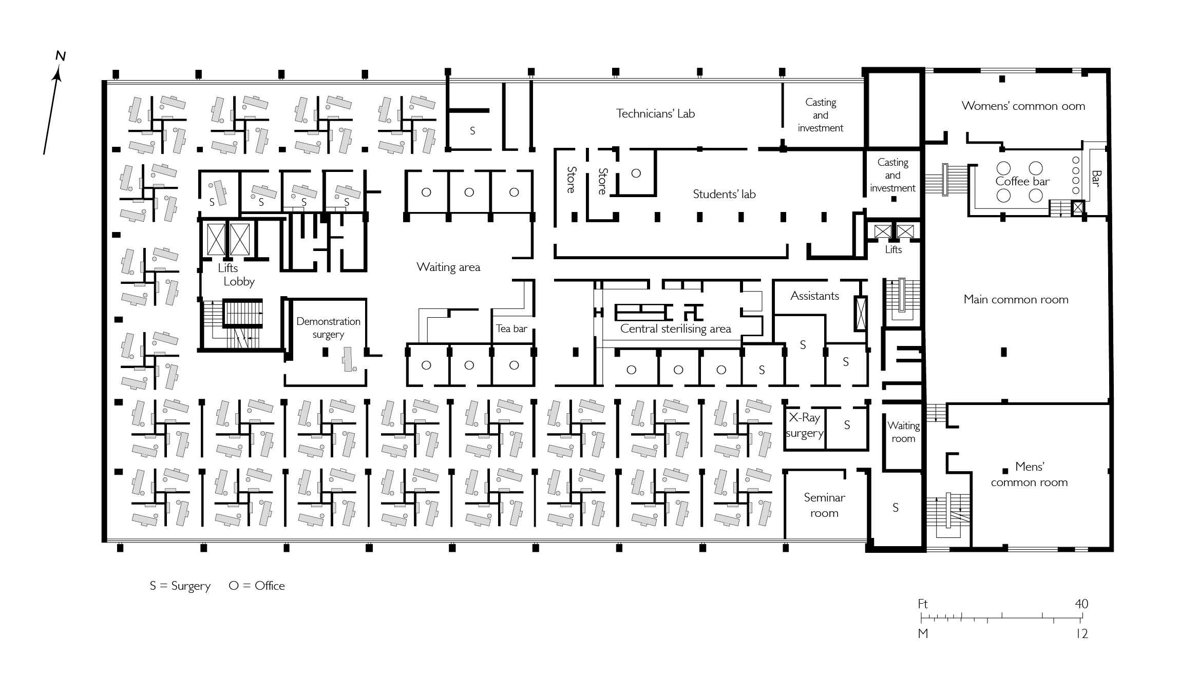
[
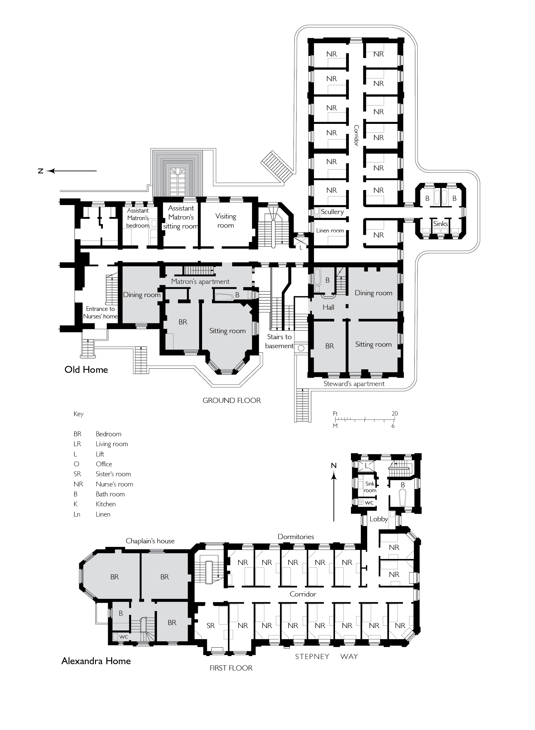
-0.060858061981046,
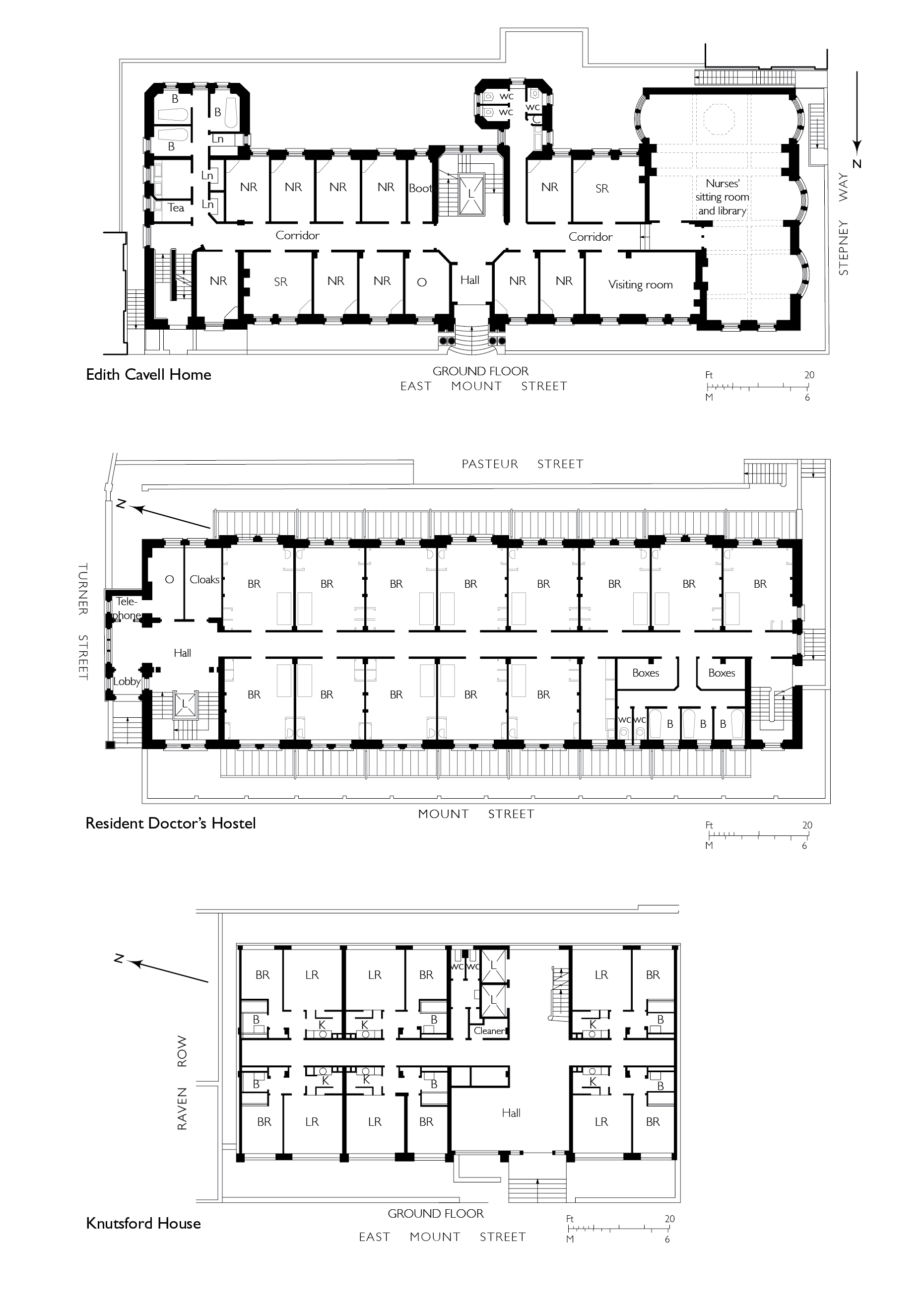
51.517297370705585
],
[
-0.060852072355982,
51.51729777282787
],
[
-0.060850777279358,
51.517292038613824
],
[
-0.060836585058279,
51.51723251416014
],
[
-0.060769976187858,
51.51723703364601
],
[
-0.060780310614954,
51.51729938465229
],
[
-0.060851422100426,
51.517294893689865
],
[
-0.060852072355982,
51.51729777282787
],
[
-0.060780756007888,
51.51730231203111
],
[
-0.060433008250066,
51.51733065140396
],
[
-0.060436612097579,
51.51734759826428
],
[
-0.060301835648786,
51.517358754570346
],
[
-0.060301267692063,
51.517334324990614
],
[
-0.060276367898553,
51.517334550322296
],
[
-0.060277606963858,
51.51738784759974
],
[
-0.060240911793285,
51.51738817966408
],
[
-0.060239603561777,
51.51733190531689
],
[
-0.060233709433579,
51.517328890670484
],
[
-0.060224675865392,
51.517324270305814
],
[
-0.06015408706542,
51.51728816646581
],
[
-0.060146994469308,
51.51728968696465
],
[
-0.06013876083629,
51.51729145207641
],
[
-0.060122232338685,
51.51729197252953
],
[
-0.060108489079552,
51.51729240527865
],
[
-0.060095089193358,
51.517291262708895
],
[
-0.060083703724374,
51.51729029190144
],
[
-0.060071883086905,
51.51728644484157
],
[
-0.060064540680754,
51.517282150214506
],
[
-0.060058159323826,
51.51727491549124
],
[
-0.060055164331108,
51.517266693493994
],
[
-0.060055745593556,
51.51725957394812
],
[
-0.060059185744876,
51.51725076287493
],
[
-0.060064720251821,
51.51724301807266
],
[
-0.060073694330703,
51.517237266202336
],
[
-0.060084008477322,
51.51723065542268
],
[
-0.060097749600684,
51.51722563043536
],
[
-0.060110820839004,
51.517222752616206
],
[
-0.060124043459833,
51.517219841466186
],
[
-0.060189323543314,
51.51717326471942
],
[
-0.060230524081512,
51.51717027080275
],
[
-0.060225029840865,
51.51714083975863
],
[
-0.060123966783513,
51.51714818367497
],
[
-0.060109355845798,
51.51706991604146
],
[
-0.060759990305139,
51.51701795039293
],
[
-0.060811901066283,
51.51703520053784
],
[
-0.060831243559519,
51.51714443032851
],
[
-0.060823879564995,
51.51714494230656
],
[
-0.060806280310304,
51.517037602197114
],
[
-0.060758637924026,
51.51702144683871
],
[
-0.060293715895444,
51.517058443881275
],
[
-0.060305285997092,
51.51711767437194
],
[
-0.060380056450023,
51.51711283445328
],
[
-0.060382025685871,
51.5171233828903
],
[
-0.060648003222123,
51.51710939602032
],
[
-0.060636939828746,
51.517031131377244
],
[
-0.060684659737861,
51.51702734366158
],
[
-0.060703670471419,
51.51713214159525
],
[
-0.060746477467265,
51.51712961322092
],
[
-0.060749678508541,
51.517150266791134
],
[
-0.060831225907887,
51.517144845854745
],
[
-0.060845060388772,
51.51723245093664
],
[
-0.060845062076888,
51.517232461665024
]
]
]
]
},
"properties": {
"b_number": "",
"b_name": "",
"street": "Stepney Way",
"address": "St Philip's Church Library and the Royal London Museum",
"feature_type": "WHITECHAPEL_BUILDING",
"count": 52,
"search_str": "St Philip's Church Library and the Royal London Museum"
},
"tags": []
},
"file": "https://surveyoflondon.org/media/uploads/features/1063/4297413613_6f2fb29391_o.jpg",
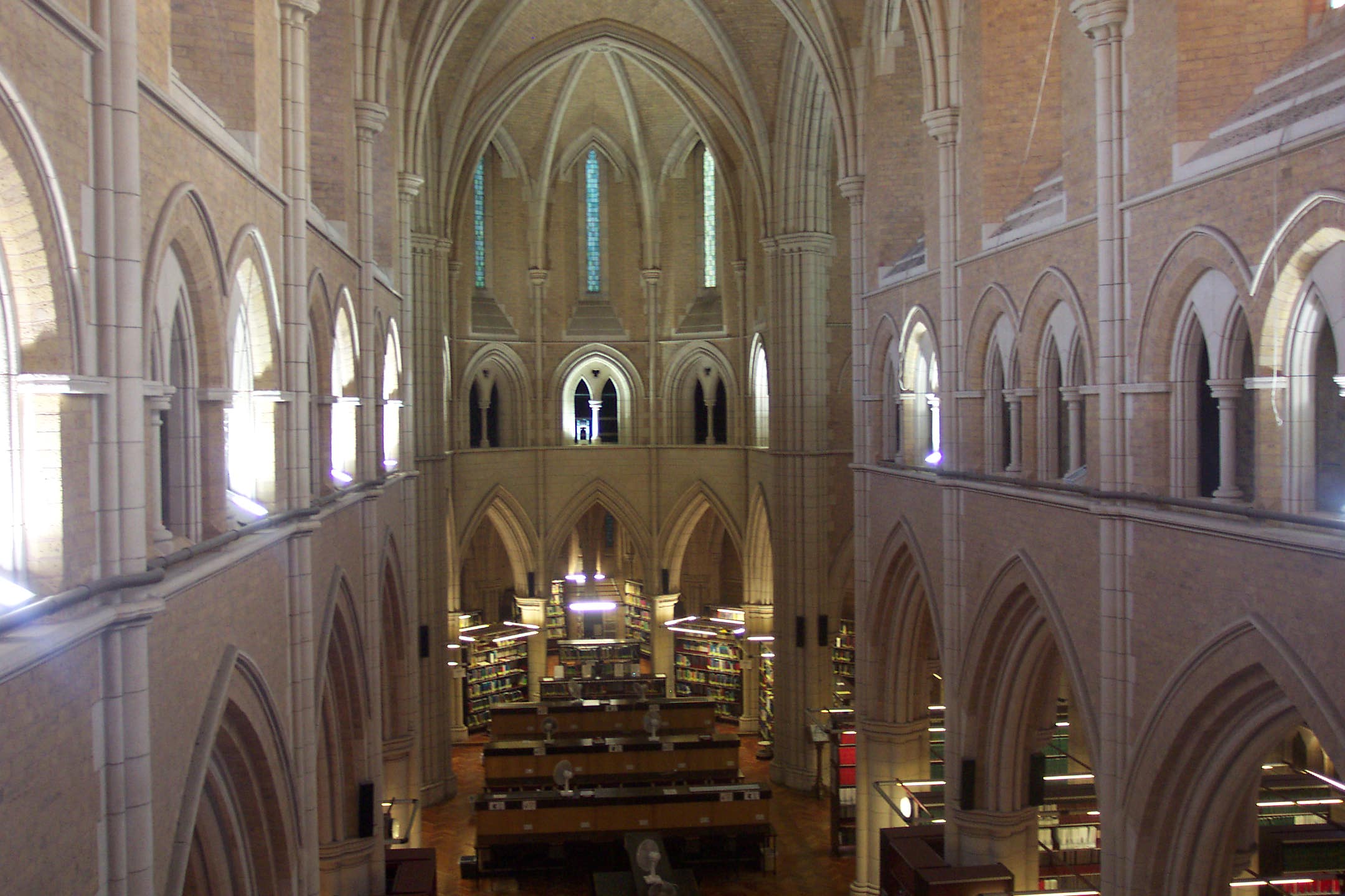
"description": "This was taken prior to the building of Ambiguous Object (housing the lift) in 2004",
"copyright": false,
"created": "2018-01-10"
}
]
}