HTTP 200 OK
Allow: GET, HEAD, OPTIONS
Content-Type: application/json
Vary: Accept
{
"count": 1747,
"next": "https://surveyoflondon.org/api/v1/images/?format=api&page=86",
"previous": "https://surveyoflondon.org/api/v1/images/?format=api&page=84",
"results": [
{
"id": 534,
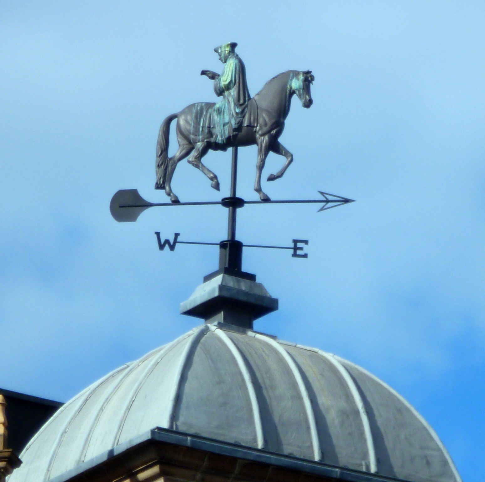
"title": "Weather Vane of Erasmus reading 'In Praise of Folly' while riding a horse backwards",
"author": {
"id": 118,
"username": "david2"
},
"feature": {
"id": 396,
"type": "Feature",
"geometry": {
"type": "MultiPolygon",
"coordinates": [
[
[
[
-0.070191183413983,
51.515943931980686
],
[
-0.070444987924411,
51.51626873485329
],
[
-0.070444999065034,
51.516268747815374
],
[
-0.070444964983339,
51.51629786697601
],
[
-0.070200105619136,
51.51635712000048
],
[
-0.07018112057321,
51.516332236247315
],
[
-0.070199532030395,
51.51632669238655
],
[
-0.070111165185554,
51.516203386086495
],
[
-0.070156100285004,
51.516193027992266
],
[
-0.070080484659871,
51.51609939740674
],
[
-0.070055650302787,
51.51610727770941
],
[
-0.070049788081592,
51.51609931840464
],
[
-0.06997681153841,
51.51601296679346
],
[
-0.07015396692832,
51.51595688181036
],
[
-0.070153962516368,
51.5159568764167
],
[
-0.070191183413983,
51.515943931980686
]
]
]
]
},
"properties": {
"b_number": "77-82",
"b_name": "Whitechapel Gallery, former Whitechapel Library",
"street": "Whitechapel High Street",
"address": "77-82 Whitechapel High Street",
"feature_type": "WHITECHAPEL_BUILDING",
"count": 9,
"search_str": "Whitechapel Gallery, former Whitechapel Library"
},
"tags": [
"art",
"gallery"
]
},
"file": "https://surveyoflondon.org/media/uploads/features/396/P1040338.JPG",
"description": "The building had been designed to be topped with a weather vane that never appeared whilst it was a GREAT Library. When the Library was taken over by the Whitechapel Gallery, they added this weather vane of Erasmus reading In Praise of Folly, his book puncturing common myths of his day. I have no idea whether the sculptor - Rodney Graham - knew or not . But up the road in Stepney was John Colet, who collaborated with Erasmus when they were both in Oxford. John Colet founded St Paul's School using some of the enormous wealth of his father. Gillian Tindall, in her book A Tunnel through Time (about the history of the Crossrail route), suggests that John Colet moved from the house his father built to another very close by. Indeed she suggests that Erasmus and Thomas More stayed in Stepney and that it was More who suggested Colet should get his own house. [1] \n\n[1]: Gillian Tindall, 'The Tunnel Through Time: A New Route for an Old London Journey' (2016), p. 110 \n \nSources\nThere are reports of the conversations and letters between Colet and Erasmus in this book https://reformationchurch.org.uk/pdf/books/seebohm/oxford-reformers_seebohn.pdf \n\nand a copy of 'In Praise of Folly': https://archive.org/details/erasmusinpraiseo00erasiala ",
"copyright": false,
"created": "2017-04-07"
},
{
"id": 1783,
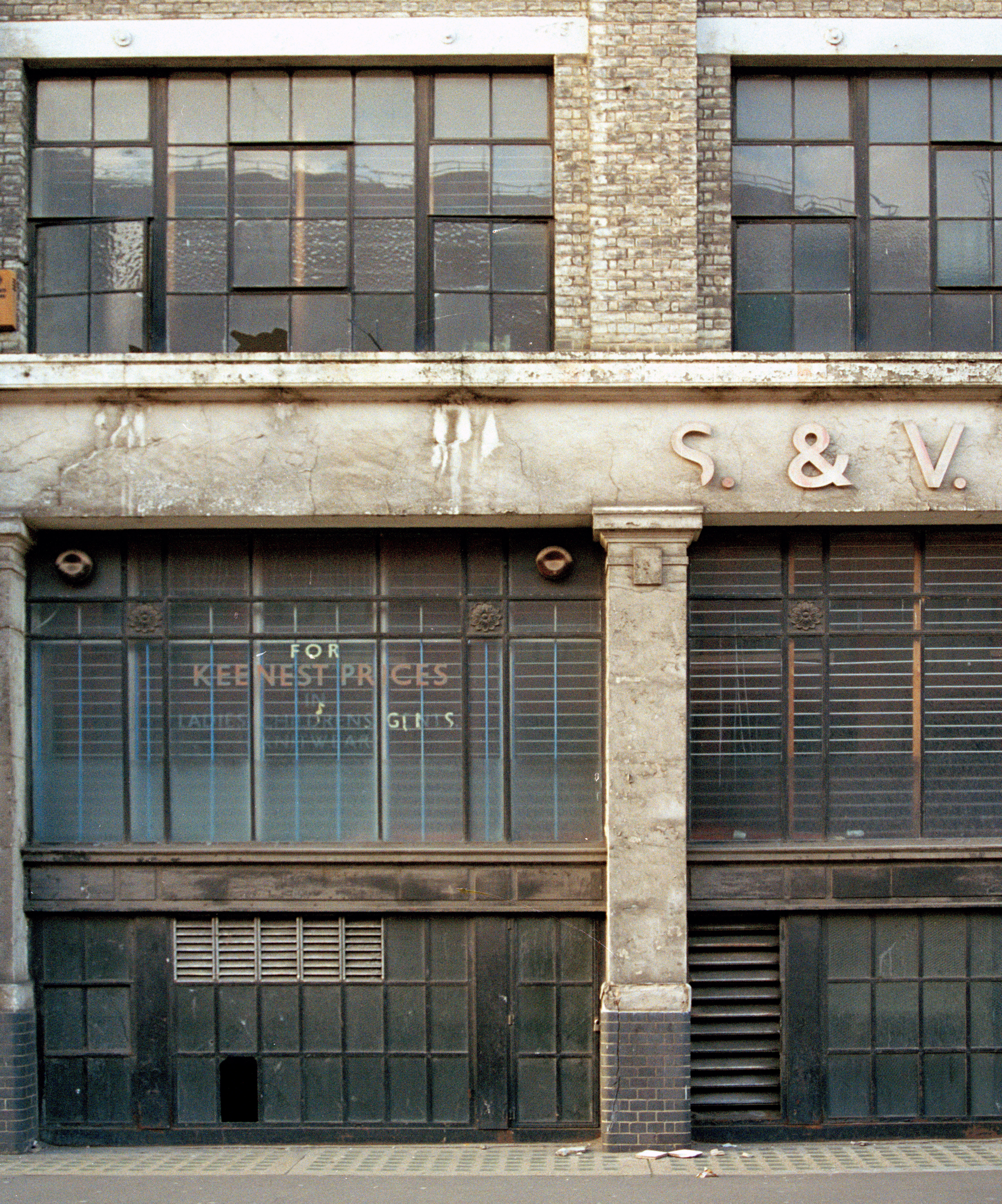
"title": "Detail of Lewis London & Sons, 1998, photo by Chris Redgrave",
"author": {
"id": 29,
"username": "CRedgrave"
},
"feature": {
"id": 987,
"type": "Feature",
"geometry": {
"type": "MultiPolygon",
"coordinates": [
[
[
[
-0.070145370299403,
51.51450072634437
],
[
-0.07014611994867,
51.51450455659268
],
[
-0.070144309574274,
51.514509535874474
],
[
-0.070140121750315,
51.51451620267396
],
[
-0.070136623713428,
51.51452004299396
],
[
-0.070132782230155,
51.51452343811338
],
[
-0.07012919823248,
51.51452605003296
],
[
-0.070032329210259,
51.51456074054102
],
[
-0.069888287217447,
51.51461232427546
],
[
-0.069840045190473,
51.514629600448345
],
[
-0.069774452824825,
51.51465322031716
],
[
-0.06976437015771,
51.514657348821736
],
[
-0.069752142738503,
51.51465949508699
],
[
-0.069738751592763,
51.514659184706524
],
[
-0.069727055003321,
51.514656294262764
],
[
-0.069718712135325,
51.51465200744966
],
[
-0.069710007581218,
51.51464360333125
],
[
-0.069703346477841,
51.51462231454975
],
[
-0.069687670795924,
51.5145762148712
],
[
-0.069654908902713,
51.514479867076176
],
[
-0.069639134856717,
51.51444518750716
],
[
-0.069621768125469,
51.51441285371942
],
[
-0.069616967605489,
51.5143964229486
],
[
-0.069618177681695,
51.51438973157497
],
[
-0.069621435653496,
51.51437947349934
],
[
-0.069630708154631,
51.51436447257293
],
[
-0.069646015054674,
51.51435269798059
],
[
-0.069669258695001,
51.51434149605311
],
[
-0.06990815956914,
51.514236930554475
],
[
-0.070061827306772,
51.51416967057941
],
[
-0.070205488914527,
51.51432361317142
],
[
-0.070080560753047,
51.51437793580642
],
[
-0.070064472214771,
51.51438470803152
],
[
-0.070066767405088,
51.51439004684161
],
[
-0.070083931212681,
51.514419269950324
],
[
-0.070132489860627,
51.51448663206476
],
[
-0.070141902651642,
51.514496931909626
],
[
-0.070145370299403,
51.51450072634437
]
]
]
]
},
"properties": {
"b_number": "71",
"b_name": "Altitude Point",
"street": "Alie Street",
"address": "71 (Altitude Point) and 81 Alie Street with 9 Buckle Street (Goldpence Apartments)",
"feature_type": "WHITECHAPEL_BUILDING",
"count": 11,
"search_str": "Altitude Point"
},
"tags": []
},
"file": "https://surveyoflondon.org/media/uploads/features/987/Detail%20of%2061-75%20Allie%20Street%20in%201998.%20Demolished.jpg",
"description": "",
"copyright": true,
"created": "2020-10-01"
},
{
"id": 1784,
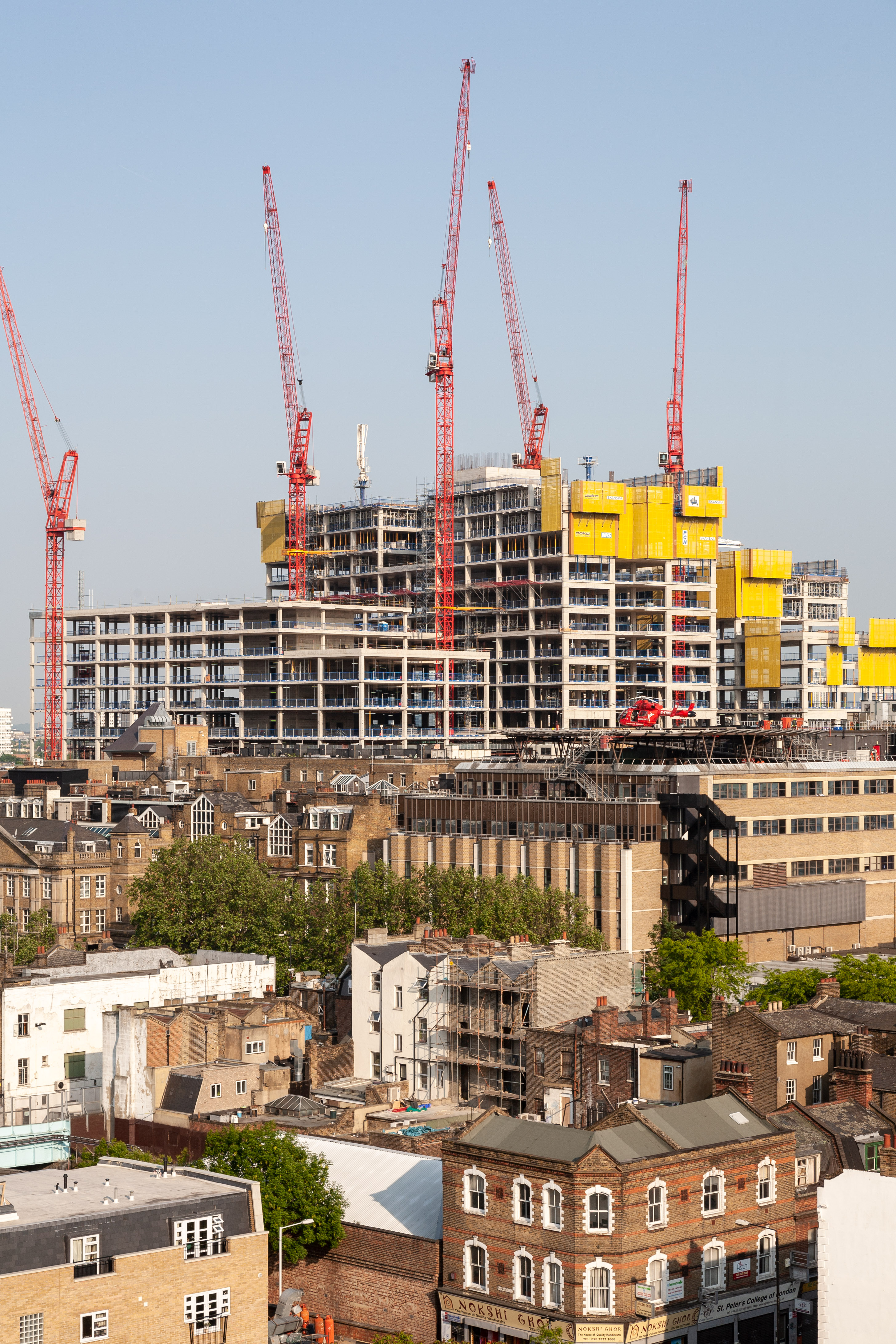
"title": "Royal London Hospital under construction, c.2010, photograph by Chris Redgrave",
"author": {
"id": 29,
"username": "CRedgrave"
},
"feature": {
"id": 1055,
"type": "Feature",
"geometry": {
"type": "MultiPolygon",
"coordinates": [
[
[
[
-0.059603168139066,
51.51814636262423
],
[
-0.05875064513042,
51.51833756100746
],
[
-0.05880027021497,
51.518428132403216
],
[
-0.058410175950557,
51.51851717894338
],
[
-0.058335119342649,
51.518387426557936
],
[
-0.058167883621195,
51.51840165384316
],
[
-0.058022191519375,
51.51770291533161
],
[
-0.058048225832449,
51.51770082847909
],
[
-0.0579567547367,
51.51754022786524
],
[
-0.057495813231092,
51.51758034522329
],
[
-0.057465726563153,
51.517443962991116
],
[
-0.057673016552398,
51.517425768571606
],
[
-0.057646690264841,
51.51729977054202
],
[
-0.057699256976843,
51.517294411534294
],
[
-0.059206618543123,
51.51716361286622
],
[
-0.05935638144775,
51.51742122218897
],
[
-0.059104959322273,
51.51744251080535
],
[
-0.059176189888187,
51.51756734317978
],
[
-0.05939181053717,
51.51754735040721
],
[
-0.059446707065502,
51.517822454567046
],
[
-0.059415919392695,
51.51782446306142
],
[
-0.059603168139066,
51.51814636262423
]
]
]
]
},
"properties": {
"b_number": "",
"b_name": "",
"street": "Stepney Way",
"address": "The Royal London Hospital",
"feature_type": "WHITECHAPEL_BUILDING",
"count": 13,
"search_str": "The Royal London Hospital"
},
"tags": []
},
"file": "https://surveyoflondon.org/media/uploads/features/1055/Royal%20London%20Hospital%20being%20built%20IMG_7059%202.jpg",
"description": "",
"copyright": true,
"created": "2020-10-01"
},
{
"id": 1785,
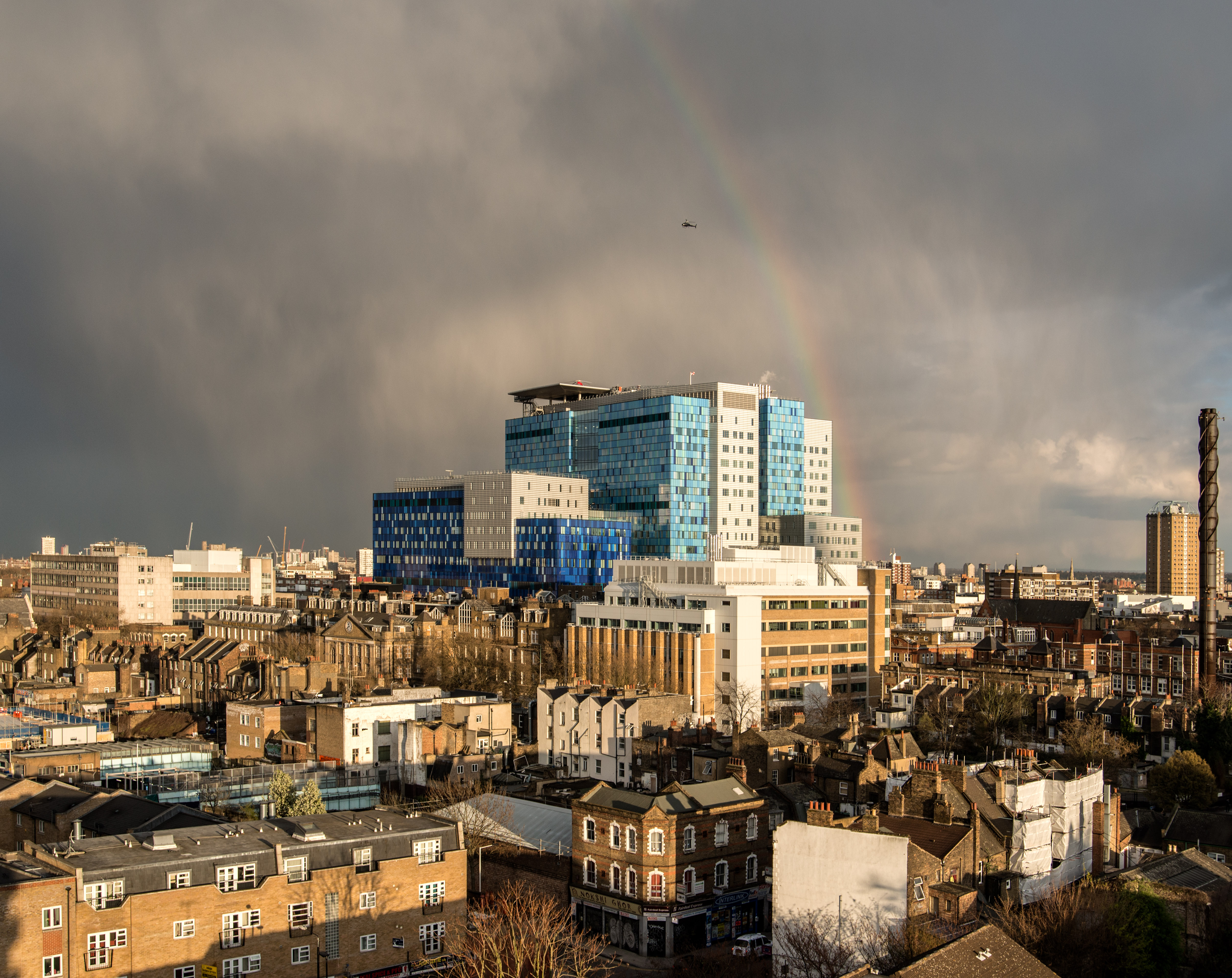
"title": "Royal London Hospital, view from the north-west in 2013, photograph by Chris Redgrave",
"author": {
"id": 29,
"username": "CRedgrave"
},
"feature": {
"id": 1055,
"type": "Feature",
"geometry": {
"type": "MultiPolygon",
"coordinates": [
[
[
[
-0.059603168139066,
51.51814636262423
],
[
-0.05875064513042,
51.51833756100746
],
[
-0.05880027021497,
51.518428132403216
],
[
-0.058410175950557,
51.51851717894338
],
[
-0.058335119342649,
51.518387426557936
],
[
-0.058167883621195,
51.51840165384316
],
[
-0.058022191519375,
51.51770291533161
],
[
-0.058048225832449,
51.51770082847909
],
[
-0.0579567547367,
51.51754022786524
],
[
-0.057495813231092,
51.51758034522329
],
[
-0.057465726563153,
51.517443962991116
],
[
-0.057673016552398,
51.517425768571606
],
[
-0.057646690264841,
51.51729977054202
],
[
-0.057699256976843,
51.517294411534294
],
[
-0.059206618543123,
51.51716361286622
],
[
-0.05935638144775,
51.51742122218897
],
[
-0.059104959322273,
51.51744251080535
],
[
-0.059176189888187,
51.51756734317978
],
[
-0.05939181053717,
51.51754735040721
],
[
-0.059446707065502,
51.517822454567046
],
[
-0.059415919392695,
51.51782446306142
],
[
-0.059603168139066,
51.51814636262423
]
]
]
]
},
"properties": {
"b_number": "",
"b_name": "",
"street": "Stepney Way",
"address": "The Royal London Hospital",
"feature_type": "WHITECHAPEL_BUILDING",
"count": 13,
"search_str": "The Royal London Hospital"
},
"tags": []
},
"file": "https://surveyoflondon.org/media/uploads/features/1055/Royal%20London%20Hospital%20with%20rainbow_DSC7330-Edit.jpg",
"description": "",
"copyright": true,
"created": "2020-10-01"
},
{
"id": 1786,
"title": "Royal London Hospital, view from the north-west c.1999, photograph by Chris Redgrave",
"author": {
"id": 29,
"username": "CRedgrave"
},
"feature": {
"id": 1055,
"type": "Feature",
"geometry": {
"type": "MultiPolygon",
"coordinates": [
[
[
[
-0.059603168139066,
51.51814636262423
],
[
-0.05875064513042,
51.51833756100746
],
[
-0.05880027021497,
51.518428132403216
],
[
-0.058410175950557,
51.51851717894338
],
[
-0.058335119342649,
51.518387426557936
],
[
-0.058167883621195,
51.51840165384316
],
[
-0.058022191519375,
51.51770291533161
],
[
-0.058048225832449,
51.51770082847909
],
[
-0.0579567547367,
51.51754022786524
],
[
-0.057495813231092,
51.51758034522329
],
[
-0.057465726563153,
51.517443962991116
],
[
-0.057673016552398,
51.517425768571606
],
[
-0.057646690264841,
51.51729977054202
],
[
-0.057699256976843,
51.517294411534294
],
[
-0.059206618543123,
51.51716361286622
],
[
-0.05935638144775,
51.51742122218897
],
[
-0.059104959322273,
51.51744251080535
],
[
-0.059176189888187,
51.51756734317978
],
[
-0.05939181053717,
51.51754735040721
],
[
-0.059446707065502,
51.517822454567046
],
[
-0.059415919392695,
51.51782446306142
],
[
-0.059603168139066,
51.51814636262423
]
]
]
]
},
"properties": {
"b_number": "",
"b_name": "",
"street": "Stepney Way",
"address": "The Royal London Hospital",
"feature_type": "WHITECHAPEL_BUILDING",
"count": 13,
"search_str": "The Royal London Hospital"
},
"tags": []
},
"file": "https://surveyoflondon.org/media/uploads/features/1055/View%20towards%20Whitechapel%20Hospital%20circa%201999.jpg",
"description": "",
"copyright": true,
"created": "2020-10-01"
},
{
"id": 1815,
"title": "74 Whitechapel High Street in 2021",
"author": {
"id": 27,
"username": "DerekKendall"
},
"feature": {
"id": 313,
"type": "Feature",
"geometry": {
"type": "MultiPolygon",
"coordinates": [
[
[
[
-0.069899913067935,
51.51612790461924
],
[
-0.069839115216482,
51.51615034260828
],
[
-0.069792900937279,
51.51608762140393
],
[
-0.069841762455144,
51.516064524555695
],
[
-0.069899913067935,
51.51612790461924
]
]
]
]
},
"properties": {
"b_number": "74",
"b_name": "74 Whitechapel High Street",
"street": "Whitechapel High Street",
"address": "74 Whitechapel High Street",
"feature_type": "WHITECHAPEL_BUILDING",
"count": 5,
"search_str": "74 Whitechapel High Street"
},
"tags": []
},
"file": "https://surveyoflondon.org/media/uploads/features/313/SoL%20Whitechapel%20102884.jpg",
"description": "",
"copyright": true,
"created": "2021-03-30"
},
{
"id": 1799,
"title": "George Yard Works Depot, block plan in 1914 - drawing by Helen Jones",
"author": {
"id": 2,
"username": "surveyoflondon"
},
"feature": {
"id": 393,
"type": "Feature",
"geometry": {
"type": "MultiPolygon",
"coordinates": [
[
[
[
-0.071315563094337,
51.51642686515904
],
[
-0.071147761319042,
51.51648833942075
],
[
-0.070848700497228,
51.51617056685727
],
[
-0.071010815043599,
51.51611117624503
],
[
-0.071127640700614,
51.51624233423094
],
[
-0.071315563094337,
51.51642686515904
]
]
]
]
},
"properties": {
"b_number": "3",
"b_name": "3 Gunthorpe Street",
"street": "Gunthorpe Street",
"address": "3 Gunthorpe Street",
"feature_type": "WHITECHAPEL_BUILDING",
"count": 6,
"search_str": "3 Gunthorpe Street"
},
"tags": []
},
"file": "https://surveyoflondon.org/media/uploads/features/393/George's%20yard%20council%20depot%20FINAL%202.jpg",
"description": "",
"copyright": true,
"created": "2021-02-10"
},
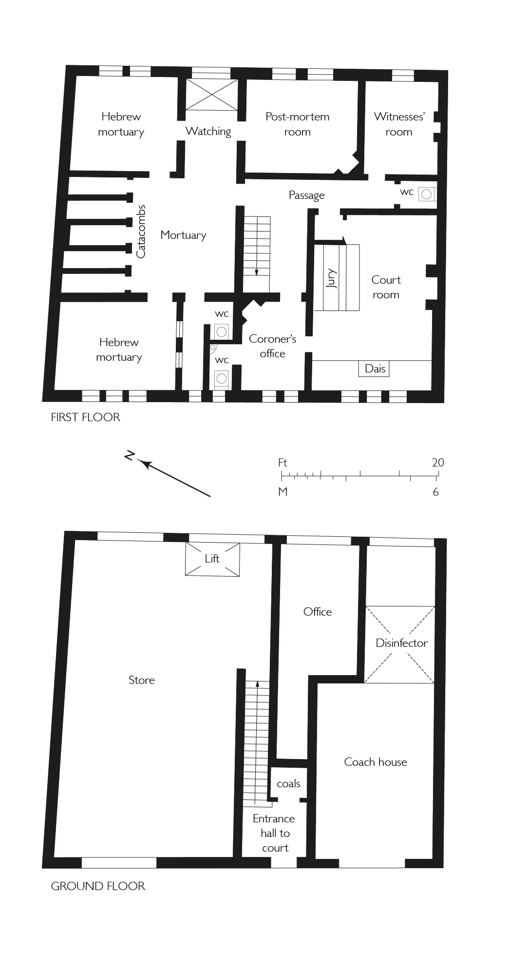
{
"id": 1800,
"title": "George Yard Mortuary and Coroner's Court, plans as built in 1891 - drawing by Helen Jones",
"author": {
"id": 2,
"username": "surveyoflondon"
},
"feature": {
"id": 393,
"type": "Feature",
"geometry": {
"type": "MultiPolygon",
"coordinates": [
[
[
[
-0.071315563094337,
51.51642686515904
],
[
-0.071147761319042,
51.51648833942075
],
[
-0.070848700497228,
51.51617056685727
],
[
-0.071010815043599,
51.51611117624503
],
[
-0.071127640700614,
51.51624233423094
],
[
-0.071315563094337,
51.51642686515904
]
]
]
]
},
"properties": {
"b_number": "3",
"b_name": "3 Gunthorpe Street",
"street": "Gunthorpe Street",
"address": "3 Gunthorpe Street",
"feature_type": "WHITECHAPEL_BUILDING",
"count": 6,
"search_str": "3 Gunthorpe Street"
},
"tags": []
},
"file": "https://surveyoflondon.org/media/uploads/features/393/Coroners%20court%20plans%20final.jpg",
"description": "",
"copyright": true,
"created": "2021-02-10"
},
{
"id": 1781,
"title": "Gardiner's Corner in the late 1990s, showing the Sedgwick Sports and Conference Centre of 1982–5, photo by Chris Redgrave",
"author": {
"id": 29,
"username": "CRedgrave"
},
"feature": {
"id": 1442,
"type": "Feature",
"geometry": {
"type": "MultiPolygon",
"coordinates": [
[
[
[
-0.070921854694497,
51.51498364468987
],
[
-0.070540769095193,
51.514951281772646
],
[
-0.070585982363243,
51.514704808586835
],
[
-0.070963912170839,
51.51473565631881
],
[
-0.070921854694497,
51.51498364468987
]
]
]
]
},
"properties": {
"b_number": "",
"b_name": "Aldgate Place",
"street": "Buckle Street",
"address": "Clayton Hotel, Aldgate Place, Buckle Street",
"feature_type": "WHITECHAPEL_BUILDING",
"count": 4,
"search_str": "Aldgate Place"
},
"tags": []
},
"file": "https://surveyoflondon.org/media/uploads/features/1442/Demolished%20PoMo%20building.jpg",
"description": "",
"copyright": true,
"created": "2020-10-01"
},
{
"id": 1824,
"title": "3 Vallance Road in 2009",
"author": {
"id": 29,
"username": "CRedgrave"
},
"feature": {
"id": 467,
"type": "Feature",
"geometry": {
"type": "MultiPolygon",
"coordinates": [
[
[
[
-0.063156515277658,
51.51874568134991
],
[
-0.0630649796894,
51.518767682046445
],
[
-0.063050592265425,
51.518736777559546
],
[
-0.063137476052168,
51.51871888638596
],
[
-0.063156515277658,
51.51874568134991
]
]
]
]
},
"properties": {
"b_number": "3",
"b_name": "",
"street": "Vallance Road",
"address": "3 Vallance Road",
"feature_type": "WHITECHAPEL_BUILDING",
"count": 3,
"search_str": "3 Vallance Road"
},
"tags": []
},
"file": "https://surveyoflondon.org/media/uploads/features/467/Vallance%20Road-2009%20copy.jpg",
"description": "",
"copyright": true,
"created": "2021-04-26"
},
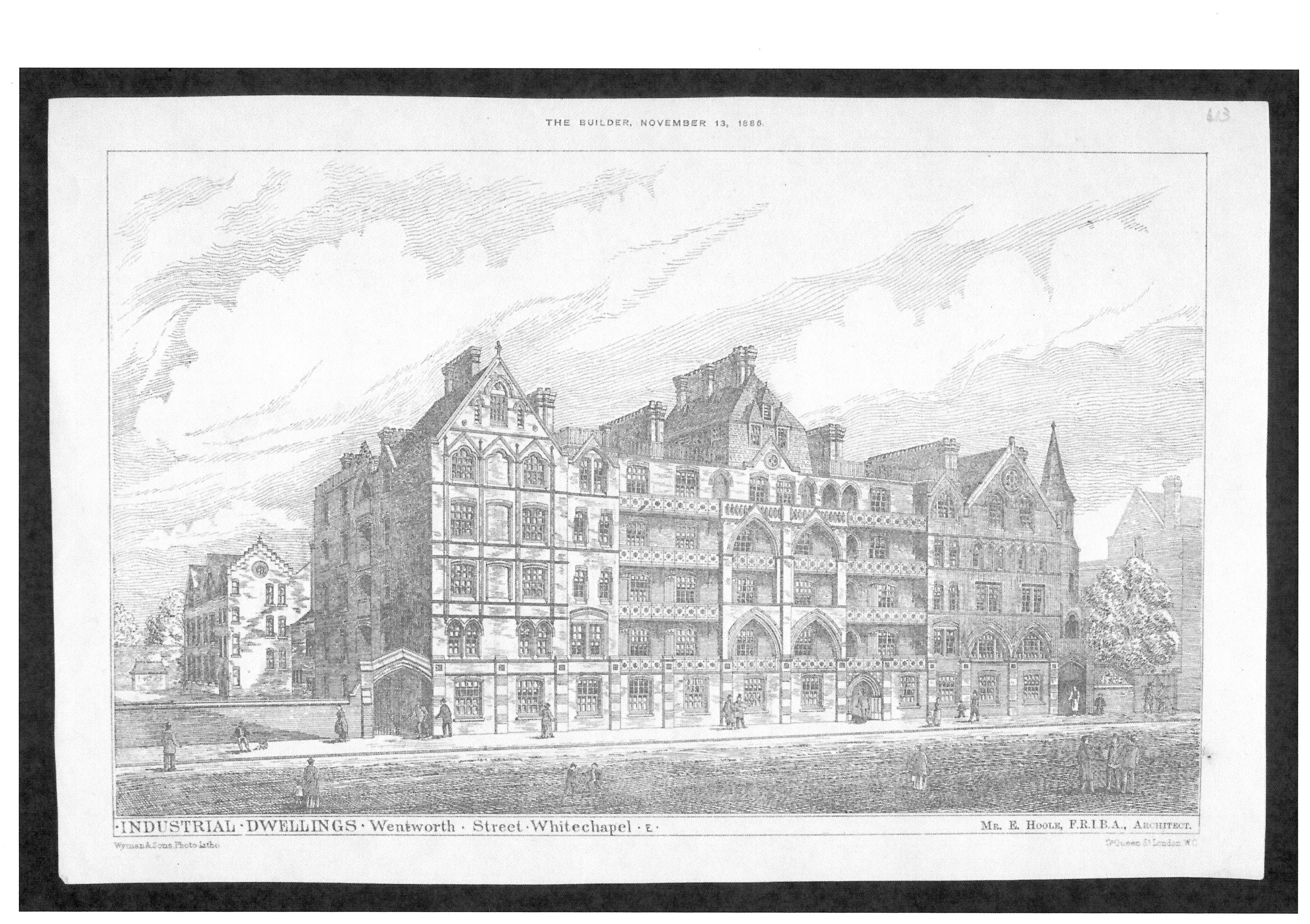
{
"id": 1835,
"title": "College Buildings, from 'The Builder', 13 November 1886",
"author": {
"id": 2,
"username": "surveyoflondon"
},
"feature": {
"id": 380,
"type": "Feature",
"geometry": {
"type": "MultiPolygon",
"coordinates": [
[
[
[
-0.072206019676478,
51.51693680017776
],
[
-0.07196249597772,
51.51695746576063
],
[
-0.071942669522335,
51.51691176033737
],
[
-0.07193864174443,
51.51687683260662
],
[
-0.0719558598767,
51.51687195131619
],
[
-0.071940018682487,
51.516849661344565
],
[
-0.071948572675229,
51.51684695053907
],
[
-0.071928740996398,
51.51681739256845
],
[
-0.072016766264098,
51.51679133268639
],
[
-0.072069141958081,
51.51685492594651
],
[
-0.072148483627081,
51.51684727546371
],
[
-0.072142511287946,
51.51682066806651
],
[
-0.072177857813757,
51.51681788202521
],
[
-0.072183448760406,
51.51684444436341
],
[
-0.072206188136717,
51.5169328110988
],
[
-0.072206015279985,
51.5169367972863
],
[
-0.072206019676478,
51.51693680017776
]
]
]
]
},
"properties": {
"b_number": "",
"b_name": "College East",
"street": "Gunthorpe Street",
"address": "College East, Gunthorpe Street",
"feature_type": "WHITECHAPEL_BUILDING",
"count": 5,
"search_str": "College East"
},
"tags": []
},
"file": "https://surveyoflondon.org/media/uploads/features/380/10.10%20-%20College%20Buildings%2C%201885.JPG",
"description": "",
"copyright": true,
"created": "2021-05-04"
},
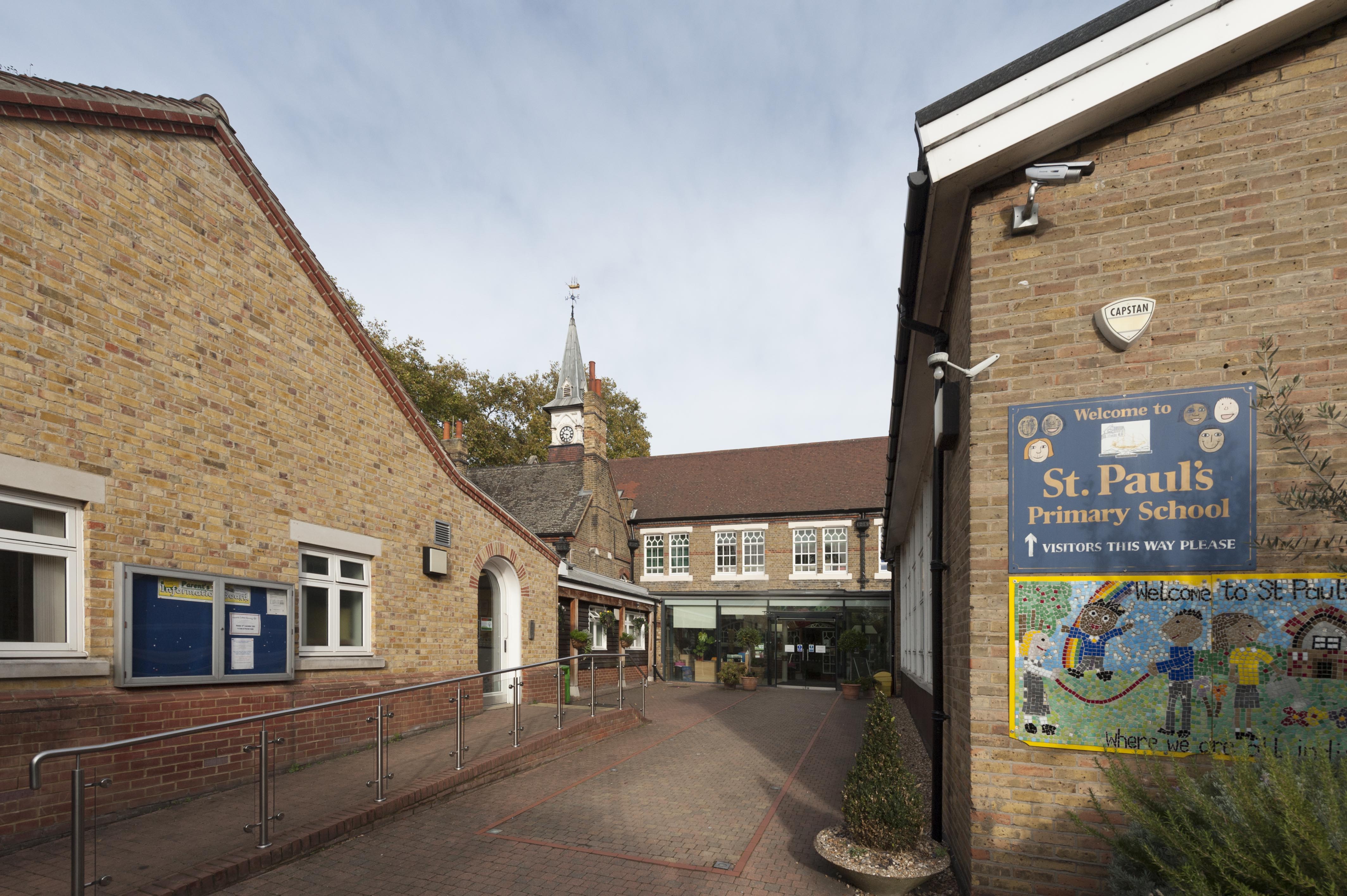
{
"id": 1434,
"title": "St Paul's School, view to south entrance, October 2018",
"author": {
"id": 27,
"username": "DerekKendall"
},
"feature": {
"id": 1399,
"type": "Feature",
"geometry": {
"type": "MultiPolygon",
"coordinates": [
[
[
[
-0.06624311370635,
51.51019072010641
],
[
-0.066077627531148,
51.510204269850675
],
[
-0.066069527116146,
51.510170337345684
],
[
-0.06611551384684,
51.51016638639934
],
[
-0.066109726117682,
51.51014703372793
],
[
-0.065814585354416,
51.5101673738921
],
[
-0.065821533323482,
51.51022330153386
],
[
-0.065683910471039,
51.51023360737856
],
[
-0.065657889334494,
51.51008339520407
],
[
-0.065349361164399,
51.51010853754948
],
[
-0.06532938777826,
51.510008209650636
],
[
-0.065633994165545,
51.509987653756085
],
[
-0.065620188745178,
51.50991765971934
],
[
-0.065722948991599,
51.50991121538507
],
[
-0.065716780377172,
51.509880881568165
],
[
-0.065901817537395,
51.50986765480321
],
[
-0.06593178354119,
51.50999605393065
],
[
-0.066038317356042,
51.509988508785376
],
[
-0.066023042932445,
51.50990918839897
],
[
-0.065998737156917,
51.50991111308007
],
[
-0.065980280001972,
51.50981894970597
],
[
-0.066320560006103,
51.50979200375635
],
[
-0.06632996113982,
51.50983401855985
],
[
-0.066268265775343,
51.50983881506029
],
[
-0.066265082872055,
51.50982597208467
],
[
-0.066214609325215,
51.509829790835916
],
[
-0.066234584593038,
51.50993011860635
],
[
-0.066179431061551,
51.509934441553284
],
[
-0.066189455574639,
51.5099837339709
],
[
-0.066197871962622,
51.509983000685985
],
[
-0.066205558541818,
51.510021498909204
],
[
-0.066199016557763,
51.510021972412325
],
[
-0.066209250254486,
51.51006632649741
],
[
-0.066216245469672,
51.51006615116071
],
[
-0.066221862792188,
51.51009851070753
],
[
-0.066214365136205,
51.51009954983773
],
[
-0.066220460291682,
51.51013162657133
],
[
-0.06623170678327,
51.51013006787535
],
[
-0.06624311370635,
51.51019072010641
]
]
]
]
},
"properties": {
"b_number": "",
"b_name": "St Paul's School",
"street": "Wellclose Square",
"address": "St Paul's School, Wellclose Square",
"feature_type": "WHITECHAPEL_BUILDING",
"count": 22,
"search_str": "St Paul's School"
},
"tags": [
"Rev. Dan Greatorex",
"Thomas F. Ford and Partners",
"Wilby & Burnett"
]
},
"file": "https://surveyoflondon.org/media/uploads/features/1399/SoL%20Whitechapel%20102316.jpg",
"description": "",
"copyright": true,
"created": "2018-11-13"
},
{
"id": 1438,
"title": "St Paul's School, entrance hall on south side of former covered playground, October 2018",
"author": {
"id": 27,
"username": "DerekKendall"
},
"feature": {
"id": 1399,
"type": "Feature",
"geometry": {
"type": "MultiPolygon",
"coordinates": [
[
[
[
-0.06624311370635,
51.51019072010641
],
[
-0.066077627531148,
51.510204269850675
],
[
-0.066069527116146,
51.510170337345684
],
[
-0.06611551384684,
51.51016638639934
],
[
-0.066109726117682,
51.51014703372793
],
[
-0.065814585354416,
51.5101673738921
],
[
-0.065821533323482,
51.51022330153386
],
[
-0.065683910471039,
51.51023360737856
],
[
-0.065657889334494,
51.51008339520407
],
[
-0.065349361164399,
51.51010853754948
],
[
-0.06532938777826,
51.510008209650636
],
[
-0.065633994165545,
51.509987653756085
],
[
-0.065620188745178,
51.50991765971934
],
[
-0.065722948991599,
51.50991121538507
],
[
-0.065716780377172,
51.509880881568165
],
[
-0.065901817537395,
51.50986765480321
],
[
-0.06593178354119,
51.50999605393065
],
[
-0.066038317356042,
51.509988508785376
],
[
-0.066023042932445,
51.50990918839897
],
[
-0.065998737156917,
51.50991111308007
],
[
-0.065980280001972,
51.50981894970597
],
[
-0.066320560006103,
51.50979200375635
],
[
-0.06632996113982,
51.50983401855985
],
[
-0.066268265775343,
51.50983881506029
],
[
-0.066265082872055,
51.50982597208467
],
[
-0.066214609325215,
51.509829790835916
],
[
-0.066234584593038,
51.50993011860635
],
[
-0.066179431061551,
51.509934441553284
],
[
-0.066189455574639,
51.5099837339709
],
[
-0.066197871962622,
51.509983000685985
],
[
-0.066205558541818,
51.510021498909204
],
[
-0.066199016557763,
51.510021972412325
],
[
-0.066209250254486,
51.51006632649741
],
[
-0.066216245469672,
51.51006615116071
],
[
-0.066221862792188,
51.51009851070753
],
[
-0.066214365136205,
51.51009954983773
],
[
-0.066220460291682,
51.51013162657133
],
[
-0.06623170678327,
51.51013006787535
],
[
-0.06624311370635,
51.51019072010641
]
]
]
]
},
"properties": {
"b_number": "",
"b_name": "St Paul's School",
"street": "Wellclose Square",
"address": "St Paul's School, Wellclose Square",
"feature_type": "WHITECHAPEL_BUILDING",
"count": 22,
"search_str": "St Paul's School"
},
"tags": [
"Rev. Dan Greatorex",
"Thomas F. Ford and Partners",
"Wilby & Burnett"
]
},
"file": "https://surveyoflondon.org/media/uploads/features/1399/SoL%20Whitechapel%20102327.jpg",
"description": "",
"copyright": true,
"created": "2018-11-13"
},
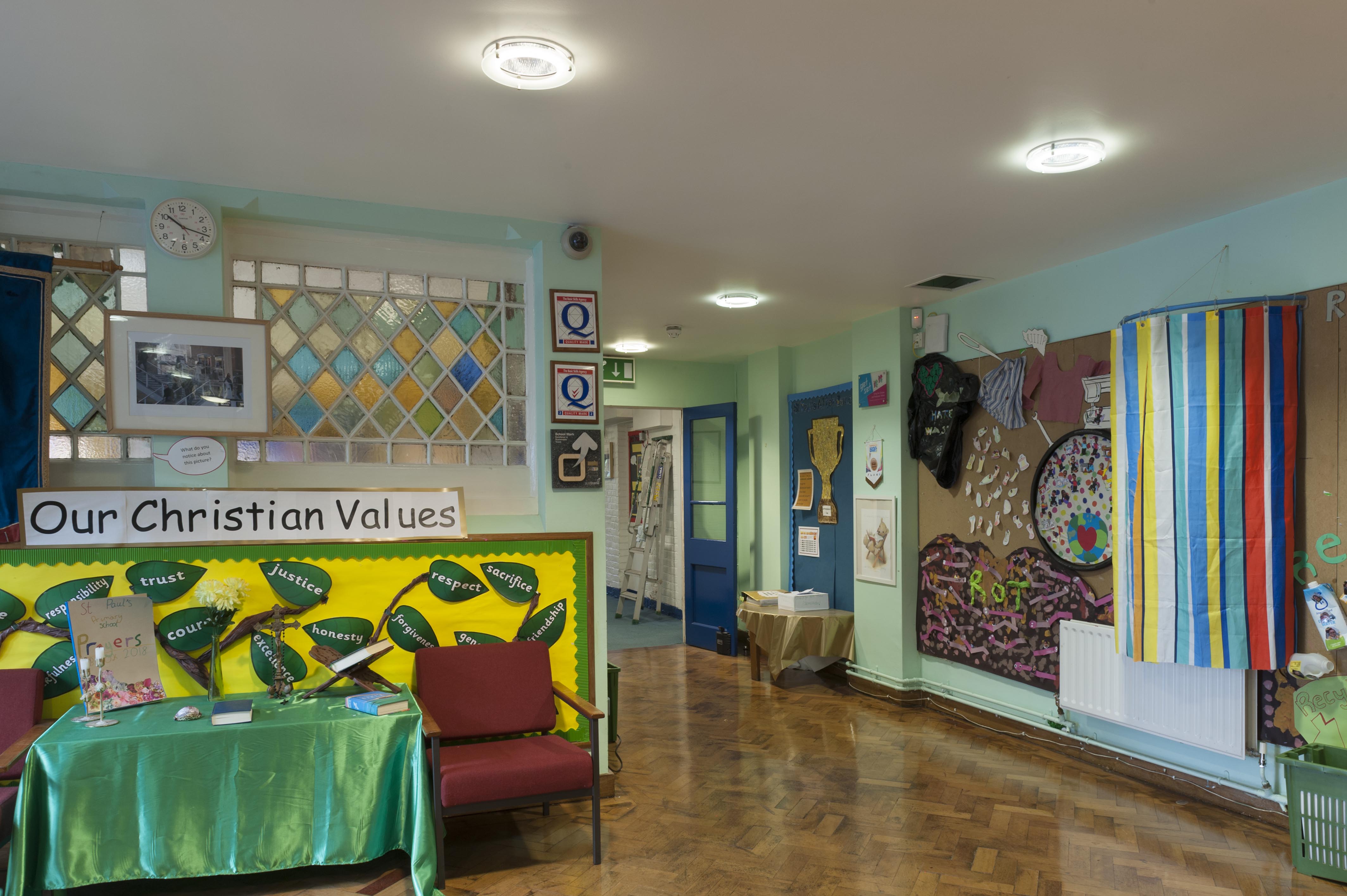
{
"id": 1439,
"title": "St Paul's School, early years (former infants') classroom, view to south, October 2018",
"author": {
"id": 27,
"username": "DerekKendall"
},
"feature": {
"id": 1399,
"type": "Feature",
"geometry": {
"type": "MultiPolygon",
"coordinates": [
[
[
[
-0.06624311370635,
51.51019072010641
],
[
-0.066077627531148,
51.510204269850675
],
[
-0.066069527116146,
51.510170337345684
],
[
-0.06611551384684,
51.51016638639934
],
[
-0.066109726117682,
51.51014703372793
],
[
-0.065814585354416,
51.5101673738921
],
[
-0.065821533323482,
51.51022330153386
],
[
-0.065683910471039,
51.51023360737856
],
[
-0.065657889334494,
51.51008339520407
],
[
-0.065349361164399,
51.51010853754948
],
[
-0.06532938777826,
51.510008209650636
],
[
-0.065633994165545,
51.509987653756085
],
[
-0.065620188745178,
51.50991765971934
],
[
-0.065722948991599,
51.50991121538507
],
[
-0.065716780377172,
51.509880881568165
],
[
-0.065901817537395,
51.50986765480321
],
[
-0.06593178354119,
51.50999605393065
],
[
-0.066038317356042,
51.509988508785376
],
[
-0.066023042932445,
51.50990918839897
],
[
-0.065998737156917,
51.50991111308007
],
[
-0.065980280001972,
51.50981894970597
],
[
-0.066320560006103,
51.50979200375635
],
[
-0.06632996113982,
51.50983401855985
],
[
-0.066268265775343,
51.50983881506029
],
[
-0.066265082872055,
51.50982597208467
],
[
-0.066214609325215,
51.509829790835916
],
[
-0.066234584593038,
51.50993011860635
],
[
-0.066179431061551,
51.509934441553284
],
[
-0.066189455574639,
51.5099837339709
],
[
-0.066197871962622,
51.509983000685985
],
[
-0.066205558541818,
51.510021498909204
],
[
-0.066199016557763,
51.510021972412325
],
[
-0.066209250254486,
51.51006632649741
],
[
-0.066216245469672,
51.51006615116071
],
[
-0.066221862792188,
51.51009851070753
],
[
-0.066214365136205,
51.51009954983773
],
[
-0.066220460291682,
51.51013162657133
],
[
-0.06623170678327,
51.51013006787535
],
[
-0.06624311370635,
51.51019072010641
]
]
]
]
},
"properties": {
"b_number": "",
"b_name": "St Paul's School",
"street": "Wellclose Square",
"address": "St Paul's School, Wellclose Square",
"feature_type": "WHITECHAPEL_BUILDING",
"count": 22,
"search_str": "St Paul's School"
},
"tags": [
"Rev. Dan Greatorex",
"Thomas F. Ford and Partners",
"Wilby & Burnett"
]
},
"file": "https://surveyoflondon.org/media/uploads/features/1399/SoL%20Whitechapel%20102329.jpg",
"description": "",
"copyright": true,
"created": "2018-11-13"
},
{
"id": 1847,
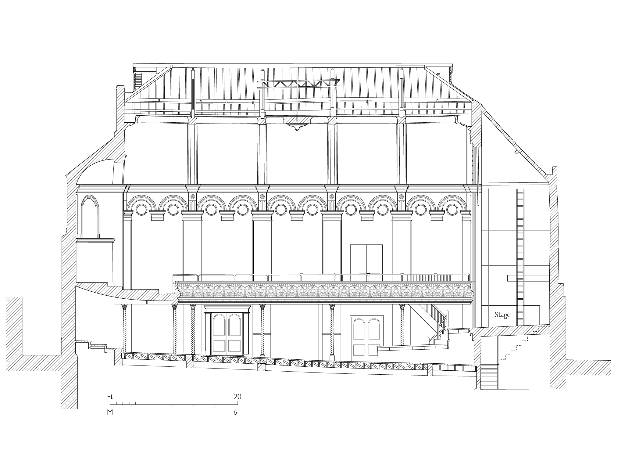
"title": "Wilton's Music Hall, section in 2015",
"author": {
"id": 82,
"username": "HelenJones"
},
"feature": {
"id": 1392,
"type": "Feature",
"geometry": {
"type": "MultiPolygon",
"coordinates": [
[
[
[
-0.066897382560978,
51.51047185184401
],
[
-0.066897150320887,
51.510543358461234
],
[
-0.066964310871808,
51.51054939761258
],
[
-0.067031736648758,
51.51055546057313
],
[
-0.067033159620775,
51.51054385631446
],
[
-0.067124985785421,
51.51055249759738
],
[
-0.067119646867151,
51.510573278551
],
[
-0.067097006082147,
51.51057630354935
],
[
-0.067064204301052,
51.510690877240464
],
[
-0.066813595729658,
51.51071232706844
],
[
-0.066808845661517,
51.510692481646345
],
[
-0.066750873450789,
51.51069733978511
],
[
-0.066731248551372,
51.51054469318253
],
[
-0.066802206282857,
51.51054121190127
],
[
-0.066805453245557,
51.51046452251118
],
[
-0.066897382560978,
51.51047185184401
]
]
]
]
},
"properties": {
"b_number": "1",
"b_name": "Wilton's Music Hall",
"street": "Graces Alley",
"address": "Wilton's Music Hall, 1 Graces Alley",
"feature_type": "WHITECHAPEL_BUILDING",
"count": 23,
"search_str": "Wilton's Music Hall"
},
"tags": [
"Wilton's Music Hall"
]
},
"file": "https://surveyoflondon.org/media/uploads/features/1392/41.29b%20wiltons%20long%20section-3.jpg",
"description": "",
"copyright": true,
"created": "2021-08-05"
},
{
"id": 1849,
"title": "Wilton's Mahogany Bar Concert Room in 1853",
"author": {
"id": 2,
"username": "surveyoflondon"
},
"feature": {
"id": 1392,
"type": "Feature",
"geometry": {
"type": "MultiPolygon",
"coordinates": [
[
[
[
-0.066897382560978,
51.51047185184401
],
[
-0.066897150320887,
51.510543358461234
],
[
-0.066964310871808,
51.51054939761258
],
[
-0.067031736648758,
51.51055546057313
],
[
-0.067033159620775,
51.51054385631446
],
[
-0.067124985785421,
51.51055249759738
],
[
-0.067119646867151,
51.510573278551
],
[
-0.067097006082147,
51.51057630354935
],
[
-0.067064204301052,
51.510690877240464
],
[
-0.066813595729658,
51.51071232706844
],
[
-0.066808845661517,
51.510692481646345
],
[
-0.066750873450789,
51.51069733978511
],
[
-0.066731248551372,
51.51054469318253
],
[
-0.066802206282857,
51.51054121190127
],
[
-0.066805453245557,
51.51046452251118
],
[
-0.066897382560978,
51.51047185184401
]
]
]
]
},
"properties": {
"b_number": "1",
"b_name": "Wilton's Music Hall",
"street": "Graces Alley",
"address": "Wilton's Music Hall, 1 Graces Alley",
"feature_type": "WHITECHAPEL_BUILDING",
"count": 23,
"search_str": "Wilton's Music Hall"
},
"tags": [
"Wilton's Music Hall"
]
},
"file": "https://surveyoflondon.org/media/uploads/features/1392/41.28%20Early%20music%20hall%201851%20scaled%20combined.jpg",
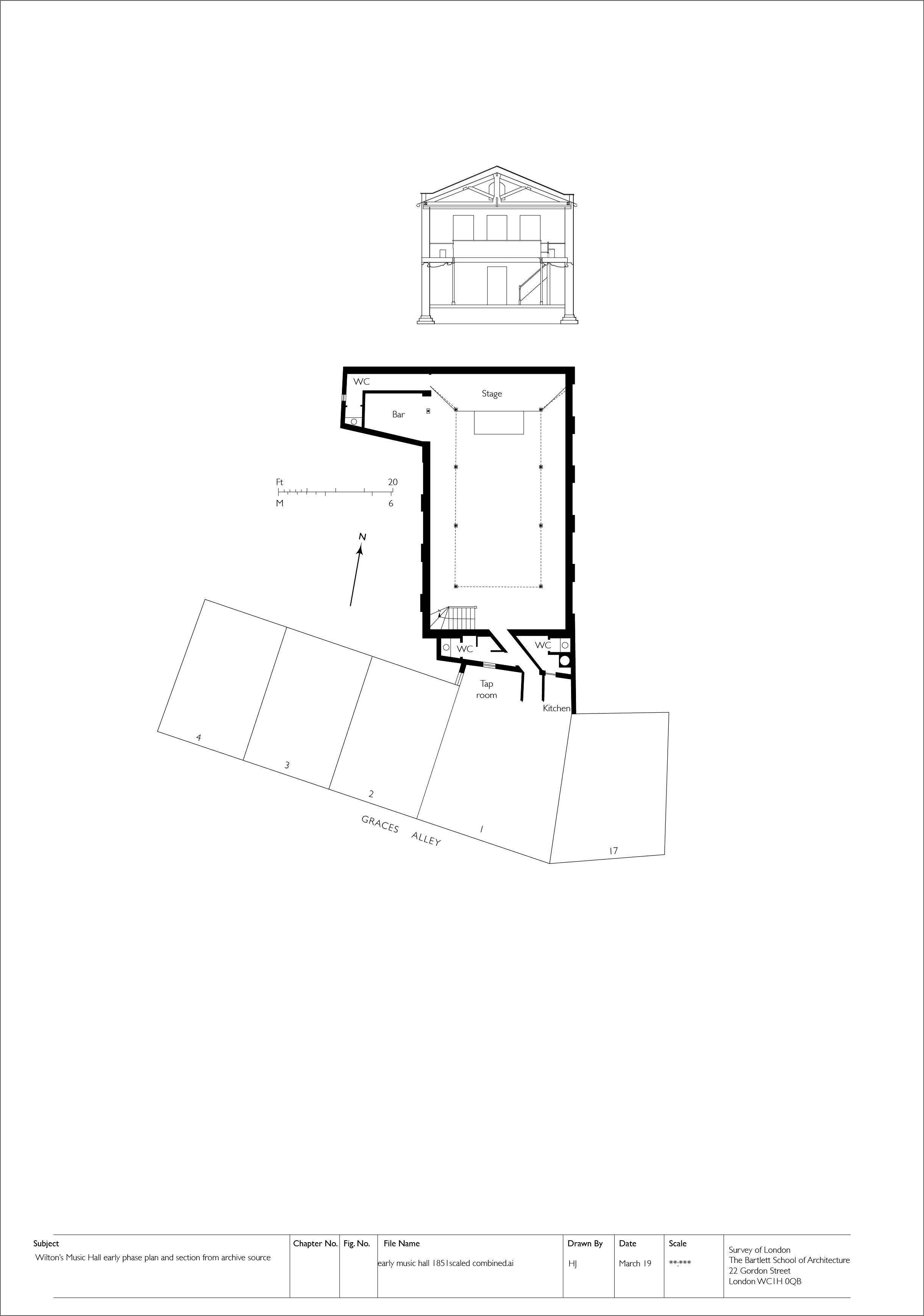
"description": "ground-floor plan and cross-section looking south, also showing 1–4 Graes Alley and 17 Wellclose Square (drawing by Helen Jones)",
"copyright": true,
"created": "2021-08-06"
},
{
"id": 1716,
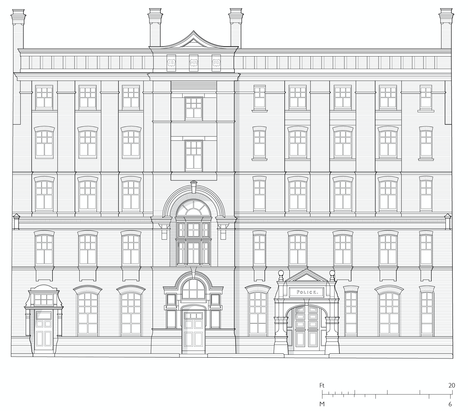
"title": "Proposed principal elevation of Leman Street Police Station, designed by John Butler in 1890",
"author": {
"id": 2,
"username": "surveyoflondon"
},
"feature": {
"id": 73,
"type": "Feature",
"geometry": {
"type": "MultiPolygon",
"coordinates": [
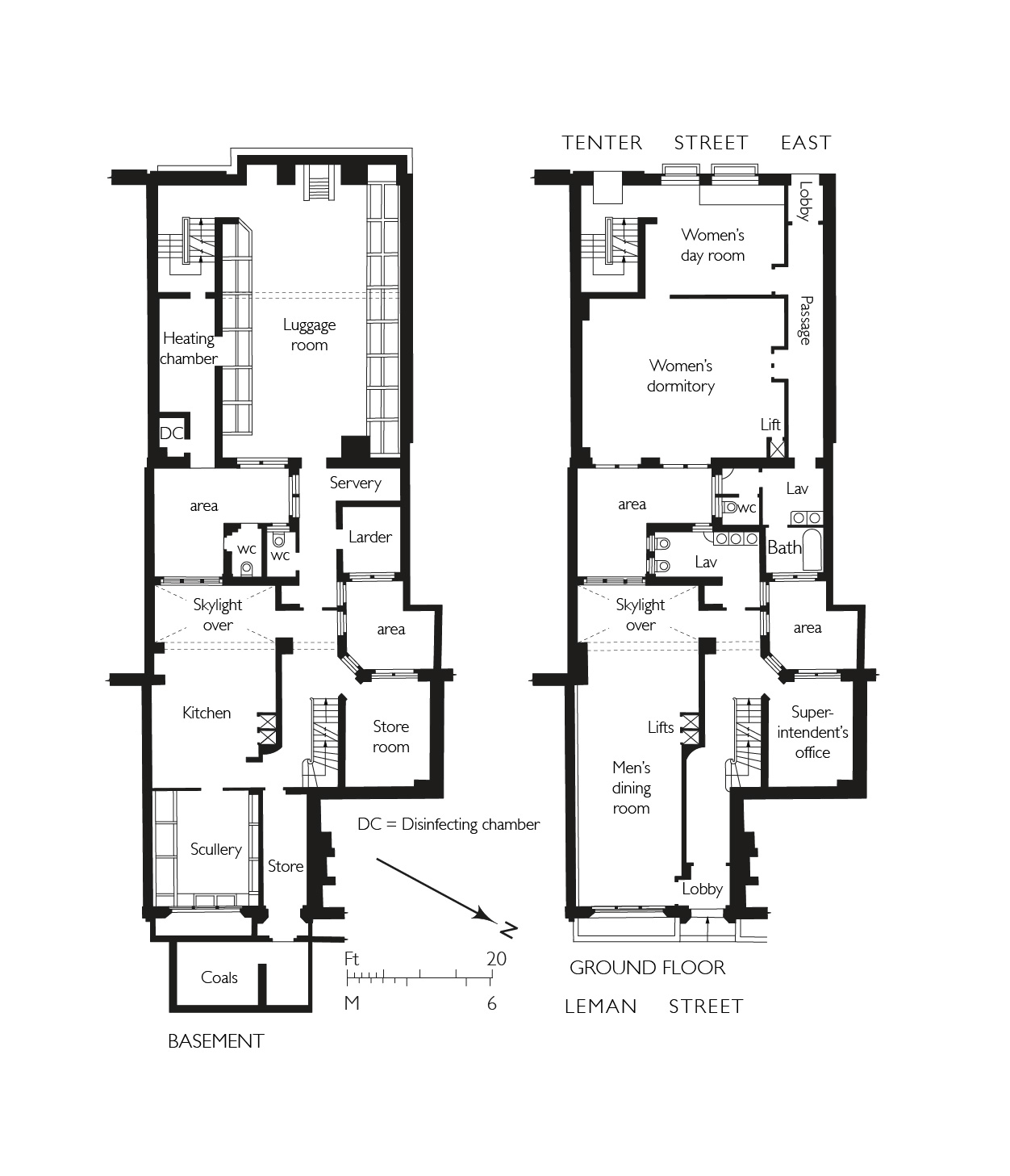
[
[
[
-0.070367322342311,
51.51301553237353
],
[
-0.07031474659871,
51.512941993636225
],
[
-0.070151719826248,
51.51298919377999
],
[
-0.069851260574291,
51.512596219574206
],
[
-0.0699963051034,
51.51255612151373
],
[
-0.070235487507054,
51.51287146226293
],
[
-0.070259147169942,
51.51286418127443
],
[
-0.070206642068876,
51.51279125317895
],
[
-0.070282120938765,
51.51276767326361
],
[
-0.070251490920689,
51.51272709430695
],
[
-0.070387507282697,
51.51268328722199
],
[
-0.070537351987533,
51.51287316293096
],
[
-0.070430553866062,
51.51290680513313
],
[
-0.070489489998683,
51.51298392076877
],
[
-0.070367322342311,
51.51301553237353
]
]
]
]
},
"properties": {
"b_number": "74",
"b_name": "",
"street": "Leman Street",
"address": "Leman Street Police Station, 74 Leman Street",
"feature_type": "WHITECHAPEL_BUILDING",
"count": 7,
"search_str": "Leman Street Police Station, 74 Leman Street"
},
"tags": []
},
"file": "https://surveyoflondon.org/media/uploads/features/73/Screen%20Shot%202020-05-22%20at%2010.20.13.png",
"description": "Drawing by Helen Jones from the Building News, 4 April 1890, p.476",
"copyright": false,
"created": "2020-05-22"
},
{
"id": 1853,
"title": "Jews' Temporary Shelter, 82 Leman Street, basement and ground-floor plans in 1905 (drawing by Helen Jones)",
"author": {
"id": 2,
"username": "surveyoflondon"
},
"feature": {
"id": 73,
"type": "Feature",
"geometry": {
"type": "MultiPolygon",
"coordinates": [
[
[
[
-0.070367322342311,
51.51301553237353
],
[
-0.07031474659871,
51.512941993636225
],
[
-0.070151719826248,
51.51298919377999
],
[
-0.069851260574291,
51.512596219574206
],
[
-0.0699963051034,
51.51255612151373
],
[
-0.070235487507054,
51.51287146226293
],
[
-0.070259147169942,
51.51286418127443
],
[
-0.070206642068876,
51.51279125317895
],
[
-0.070282120938765,
51.51276767326361
],
[
-0.070251490920689,
51.51272709430695
],
[
-0.070387507282697,
51.51268328722199
],
[
-0.070537351987533,
51.51287316293096
],
[
-0.070430553866062,
51.51290680513313
],
[
-0.070489489998683,
51.51298392076877
],
[
-0.070367322342311,
51.51301553237353
]
]
]
]
},
"properties": {
"b_number": "74",
"b_name": "",
"street": "Leman Street",
"address": "Leman Street Police Station, 74 Leman Street",
"feature_type": "WHITECHAPEL_BUILDING",
"count": 7,
"search_str": "Leman Street Police Station, 74 Leman Street"
},
"tags": []
},
"file": "https://surveyoflondon.org/media/uploads/features/73/37.20%20Jews%20temporary%20shelter%202-2.jpg",
"description": "",
"copyright": true,
"created": "2021-08-18"
},
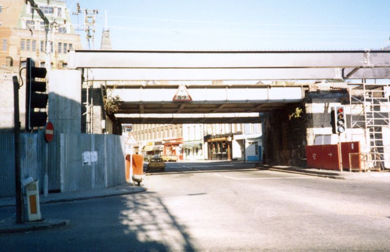
{
"id": 1150,
"title": "Building the Docklands Light Railway, c. 1985",
"author": {
"id": 153,
"username": "danny"
},
"feature": {
"id": 1284,
"type": "Feature",
"geometry": {
"type": "MultiPolygon",
"coordinates": [
[
[
[
-0.068500275953618,
51.51107508505472
],
[
-0.068478612819023,
51.51106496949243
],
[
-0.068414202464355,
51.51097498722599
],
[
-0.068521626072007,
51.51097035427303
],
[
-0.068532473079143,
51.511074986716515
],
[
-0.068500275953618,
51.51107508505472
]
]
]
]
},
"properties": {
"b_number": "",
"b_name": "",
"street": "Leman Street",
"address": "Pier in middle of Leman Street",
"feature_type": "WHITECHAPEL_BUILDING",
"count": 12,
"search_str": "Pier in middle of Leman Street"
},
"tags": []
},
"file": "https://surveyoflondon.org/media/uploads/features/1284/DLR%20Construction%20Works%20Leman%20Street%20circa%201985.jpg",
"description": "An image looking north from the junction of Leman Street with Cable Street, Dock Street and Royal Mint Street. The new girders supporting the track (not yet built) of the Docklands Light Railway are in place across Leman Street.",
"copyright": false,
"created": "2018-03-04"
},
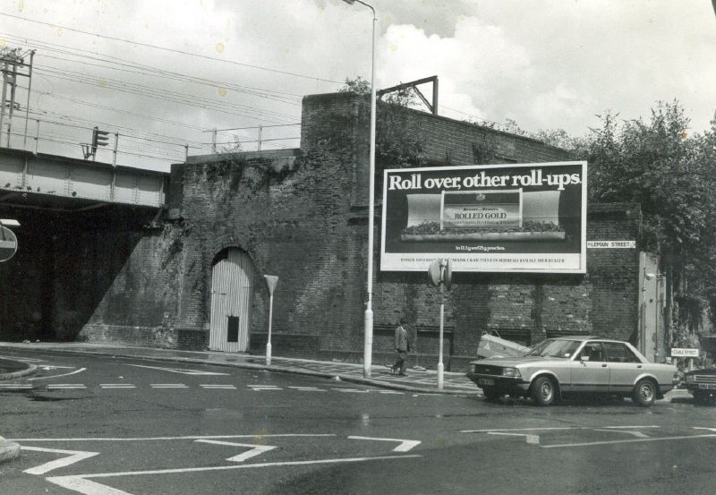
{
"id": 1165,
"title": "Leman Street station buildings 1978",
"author": {
"id": 153,
"username": "danny"
},
"feature": {
"id": 1284,
"type": "Feature",
"geometry": {
"type": "MultiPolygon",
"coordinates": [
[
[
[
-0.068500275953618,
51.51107508505472
],
[
-0.068478612819023,
51.51106496949243
],
[
-0.068414202464355,
51.51097498722599
],
[
-0.068521626072007,
51.51097035427303
],
[
-0.068532473079143,
51.511074986716515
],
[
-0.068500275953618,
51.51107508505472
]
]
]
]
},
"properties": {
"b_number": "",
"b_name": "",
"street": "Leman Street",
"address": "Pier in middle of Leman Street",
"feature_type": "WHITECHAPEL_BUILDING",
"count": 12,
"search_str": "Pier in middle of Leman Street"
},
"tags": []
},
"file": "https://surveyoflondon.org/media/uploads/features/1284/Leman%20Street%20station%20buildings.jpg",
"description": "Remains of Leman Street Station on the London Tilbury & Southend Railway in 1978. These are at the junction of Leman Street and Cable Street and before the construction of the Docklands Light Railway viaduct.",
"copyright": false,
"created": "2018-03-04"
}
]
}