HTTP 200 OK
Allow: GET, HEAD, OPTIONS
Content-Type: application/json
Vary: Accept
{
"count": 1747,
"next": "https://surveyoflondon.org/api/v1/images/?format=api&page=84",
"previous": "https://surveyoflondon.org/api/v1/images/?format=api&page=82",
"results": [
{
"id": 1746,
"title": "market on Wentworth Street in 2017",
"author": {
"id": 27,
"username": "DerekKendall"
},
"feature": {
"id": 1742,
"type": "Feature",
"geometry": {
"type": "MultiPolygon",
"coordinates": [
[
[
[
-0.076387722492951,
51.516257872286374
],
[
-0.07580974439088,
51.51649846859169
],
[
-0.075744693982384,
51.51651411423466
],
[
-0.075332716624042,
51.51665341173461
],
[
-0.075277819023276,
51.516667372076085
],
[
-0.074429584483841,
51.51681699796736
],
[
-0.074402209988697,
51.516763242480046
],
[
-0.075229889371391,
51.51661092868018
],
[
-0.074836715281391,
51.516135055700595
],
[
-0.074917049606191,
51.51611135328064
],
[
-0.075312012611936,
51.51658616747119
],
[
-0.075695505281233,
51.51646463519818
],
[
-0.075779072585588,
51.51644696856364
],
[
-0.076328753388395,
51.516209038390684
],
[
-0.076387722492951,
51.516257872286374
]
]
]
]
},
"properties": {
"b_number": "",
"b_name": "",
"street": "",
"address": "Petticoat Lane Market",
"feature_type": "PLACE",
"count": 39,
"search_str": "Petticoat Lane Market"
},
"tags": []
},
"file": "https://surveyoflondon.org/media/uploads/features/1742/SoL%20Whitechapel%20100859.jpg",
"description": "",
"copyright": true,
"created": "2020-08-04"
},
{
"id": 1747,
"title": "Market on Wentworth Street in 2017",
"author": {
"id": 27,
"username": "DerekKendall"
},
"feature": {
"id": 1742,
"type": "Feature",
"geometry": {
"type": "MultiPolygon",
"coordinates": [
[
[
[
-0.076387722492951,
51.516257872286374
],
[
-0.07580974439088,
51.51649846859169
],
[
-0.075744693982384,
51.51651411423466
],
[
-0.075332716624042,
51.51665341173461
],
[
-0.075277819023276,
51.516667372076085
],
[
-0.074429584483841,
51.51681699796736
],
[
-0.074402209988697,
51.516763242480046
],
[
-0.075229889371391,
51.51661092868018
],
[
-0.074836715281391,
51.516135055700595
],
[
-0.074917049606191,
51.51611135328064
],
[
-0.075312012611936,
51.51658616747119
],
[
-0.075695505281233,
51.51646463519818
],
[
-0.075779072585588,
51.51644696856364
],
[
-0.076328753388395,
51.516209038390684
],
[
-0.076387722492951,
51.516257872286374
]
]
]
]
},
"properties": {
"b_number": "",
"b_name": "",
"street": "",
"address": "Petticoat Lane Market",
"feature_type": "PLACE",
"count": 39,
"search_str": "Petticoat Lane Market"
},
"tags": []
},
"file": "https://surveyoflondon.org/media/uploads/features/1742/SoL%20Whitechapel%20100862_4BNwED0.jpg",
"description": "",
"copyright": true,
"created": "2020-08-04"
},
{
"id": 1748,
"title": "Petticoat Lane Market sign in 2017",
"author": {
"id": 27,
"username": "DerekKendall"
},
"feature": {
"id": 1742,
"type": "Feature",
"geometry": {
"type": "MultiPolygon",
"coordinates": [
[
[
[
-0.076387722492951,
51.516257872286374
],
[
-0.07580974439088,
51.51649846859169
],
[
-0.075744693982384,
51.51651411423466
],
[
-0.075332716624042,
51.51665341173461
],
[
-0.075277819023276,
51.516667372076085
],
[
-0.074429584483841,
51.51681699796736
],
[
-0.074402209988697,
51.516763242480046
],
[
-0.075229889371391,
51.51661092868018
],
[
-0.074836715281391,
51.516135055700595
],
[
-0.074917049606191,
51.51611135328064
],
[
-0.075312012611936,
51.51658616747119
],
[
-0.075695505281233,
51.51646463519818
],
[
-0.075779072585588,
51.51644696856364
],
[
-0.076328753388395,
51.516209038390684
],
[
-0.076387722492951,
51.516257872286374
]
]
]
]
},
"properties": {
"b_number": "",
"b_name": "",
"street": "",
"address": "Petticoat Lane Market",
"feature_type": "PLACE",
"count": 39,
"search_str": "Petticoat Lane Market"
},
"tags": []
},
"file": "https://surveyoflondon.org/media/uploads/features/1742/SoL%20Whitechapel%20100863.jpg",
"description": "",
"copyright": true,
"created": "2020-08-04"
},
{
"id": 1749,
"title": "View to the City with Petticoat Lane Market sign in 2017",
"author": {
"id": 27,
"username": "DerekKendall"
},
"feature": {
"id": 1742,
"type": "Feature",
"geometry": {
"type": "MultiPolygon",
"coordinates": [
[
[
[
-0.076387722492951,
51.516257872286374
],
[
-0.07580974439088,
51.51649846859169
],
[
-0.075744693982384,
51.51651411423466
],
[
-0.075332716624042,
51.51665341173461
],
[
-0.075277819023276,
51.516667372076085
],
[
-0.074429584483841,
51.51681699796736
],
[
-0.074402209988697,
51.516763242480046
],
[
-0.075229889371391,
51.51661092868018
],
[
-0.074836715281391,
51.516135055700595
],
[
-0.074917049606191,
51.51611135328064
],
[
-0.075312012611936,
51.51658616747119
],
[
-0.075695505281233,
51.51646463519818
],
[
-0.075779072585588,
51.51644696856364
],
[
-0.076328753388395,
51.516209038390684
],
[
-0.076387722492951,
51.516257872286374
]
]
]
]
},
"properties": {
"b_number": "",
"b_name": "",
"street": "",
"address": "Petticoat Lane Market",
"feature_type": "PLACE",
"count": 39,
"search_str": "Petticoat Lane Market"
},
"tags": []
},
"file": "https://surveyoflondon.org/media/uploads/features/1742/SoL%20Whitechapel%20100867.jpg",
"description": "",
"copyright": true,
"created": "2020-08-04"
},
{
"id": 1743,
"title": "shopfront at Arcadia Court in 2017",
"author": {
"id": 27,
"username": "DerekKendall"
},
"feature": {
"id": 359,
"type": "Feature",
"geometry": {
"type": "MultiPolygon",
"coordinates": [
[
[
[
-0.074396169724534,
51.51674677293217
],
[
-0.074344918245201,
51.51668771806432
],
[
-0.074415391815644,
51.51667127366158
],
[
-0.074407427802984,
51.51665783673676
],
[
-0.074464842346045,
51.51664692918775
],
[
-0.074451564815962,
51.516627570285934
],
[
-0.074484845350984,
51.516618730970194
],
[
-0.074449462429928,
51.5165697349019
],
[
-0.074495929828979,
51.51655683248676
],
[
-0.074450946678382,
51.516491607819624
],
[
-0.074715152431625,
51.51642099545545
],
[
-0.074553943007666,
51.516244787362865
],
[
-0.074798574993366,
51.51616849501834
],
[
-0.075086564069636,
51.51652796045754
],
[
-0.075099913362563,
51.51652379724113
],
[
-0.075167749140884,
51.51660846832082
],
[
-0.074396169724534,
51.51674677293217
]
]
]
]
},
"properties": {
"b_number": "",
"b_name": "Arcadia Court, formerly 90 to 222 Wentworth Dwellings",
"street": "Goulston Street",
"address": "Arcadia Court, formerly 90 to 222 Wentworth Dwellings",
"feature_type": "WHITECHAPEL_BUILDING",
"count": 8,
"search_str": "Arcadia Court, formerly 90 to 222 Wentworth Dwellings"
},
"tags": []
},
"file": "https://surveyoflondon.org/media/uploads/features/359/SoL%20Whitechapel%20100845.jpg",
"description": "",
"copyright": true,
"created": "2020-08-04"
},
{
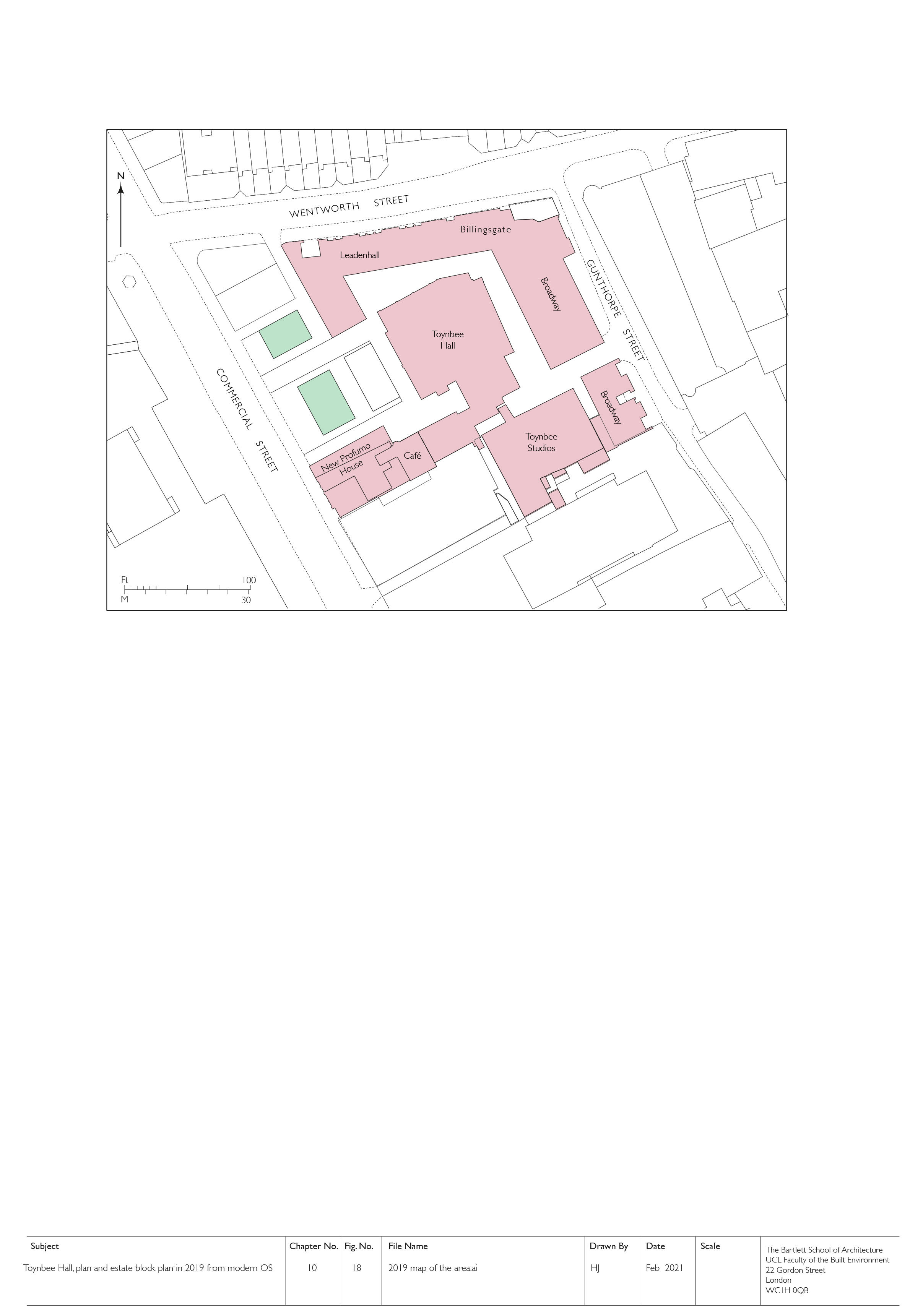
"id": 1834,
"title": "Toynbee Hall and related buildings, block plan in 2019 (drawing by Helen Jones)",
"author": {
"id": 2,
"username": "surveyoflondon"
},
"feature": {
"id": 379,
"type": "Feature",
"geometry": {
"type": "MultiPolygon",
"coordinates": [
[
[
[
-0.072397829403071,
51.51669736298538
],
[
-0.072397829775652,
51.51669737370259
],
[
-0.072432640663459,
51.51673265247548
],
[
-0.072358283763003,
51.51675511998594
],
[
-0.072392345089312,
51.51679900052574
],
[
-0.072279169019407,
51.51681120129116
],
[
-0.072260832658385,
51.516791637982884
],
[
-0.07220017871295,
51.51681376750612
],
[
-0.07215893969634,
51.516769768915125
],
[
-0.072119241451839,
51.51677664825232
],
[
-0.071934651446851,
51.5165549241745
],
[
-0.071985260710591,
51.51653955484268
],
[
-0.072028895096668,
51.51652682786407
],
[
-0.072014842692988,
51.516508073517755
],
[
-0.072098254454469,
51.51648373796318
],
[
-0.072052675375786,
51.51643004607134
],
[
-0.072144607110911,
51.516401673048335
],
[
-0.072314904588685,
51.51634652520951
],
[
-0.072358068161013,
51.516398410711595
],
[
-0.072522445522427,
51.51634491903885
],
[
-0.072499976579174,
51.51631804154615
],
[
-0.072499959446261,
51.51631804712155
],
[
-0.072499965346341,
51.51631803831239
],
[
-0.072579515746657,
51.51629075531372
],
[
-0.072667639265209,
51.516403182536045
],
[
-0.072427304765486,
51.5164813923298
],
[
-0.072385415219988,
51.51643128370629
],
[
-0.072387162242999,
51.516433383744854
],
[
-0.072107982084202,
51.516523791132904
],
[
-0.072157544605501,
51.51658336890495
],
[
-0.072272128891629,
51.51654626302576
],
[
-0.072397829403071,
51.51669736298538
]
]
]
]
},
"properties": {
"b_number": "28 ",
"b_name": "Toynbee Hall",
"street": "Commercial Street",
"address": "Toynbee Hall, 28 Commercial Street",
"feature_type": "WHITECHAPEL_BUILDING",
"count": 21,
"search_str": "Toynbee Hall"
},
"tags": []
},
"file": "https://surveyoflondon.org/media/uploads/features/379/10.18%202019%20map%20of%20the%20area.jpg",
"description": "",
"copyright": true,
"created": "2021-05-04"
},
{
"id": 1814,
"title": "Calcutta House Annexe in 2021",
"author": {
"id": 27,
"username": "DerekKendall"
},
"feature": {
"id": 358,
"type": "Feature",
"geometry": {
"type": "MultiPolygon",
"coordinates": [
[
[
[
-0.073301292007031,
51.515600211929396
],
[
-0.073213962675441,
51.51562715962755
],
[
-0.072840800408787,
51.51522217894418
],
[
-0.072928318212048,
51.515190753173876
],
[
-0.073311908683853,
51.51555288300189
],
[
-0.073274093329402,
51.51556391347805
],
[
-0.073282787850232,
51.515575537325454
],
[
-0.073437843405707,
51.51551488351492
],
[
-0.073453284587191,
51.5155300897566
],
[
-0.073295938983894,
51.5155923860951
],
[
-0.073301292007031,
51.515600211929396
]
]
]
]
},
"properties": {
"b_number": "",
"b_name": "Calcutta House annexe, Old Castle Street",
"street": "Old Castle Street",
"address": "Calcutta House Annexe, Old Castle Street",
"feature_type": "WHITECHAPEL_BUILDING",
"count": 8,
"search_str": "Calcutta House annexe, Old Castle Street"
},
"tags": []
},
"file": "https://surveyoflondon.org/media/uploads/features/358/SoL%20Whitechapel%20102879.jpg",
"description": "",
"copyright": true,
"created": "2021-03-30"
},
{
"id": 1145,
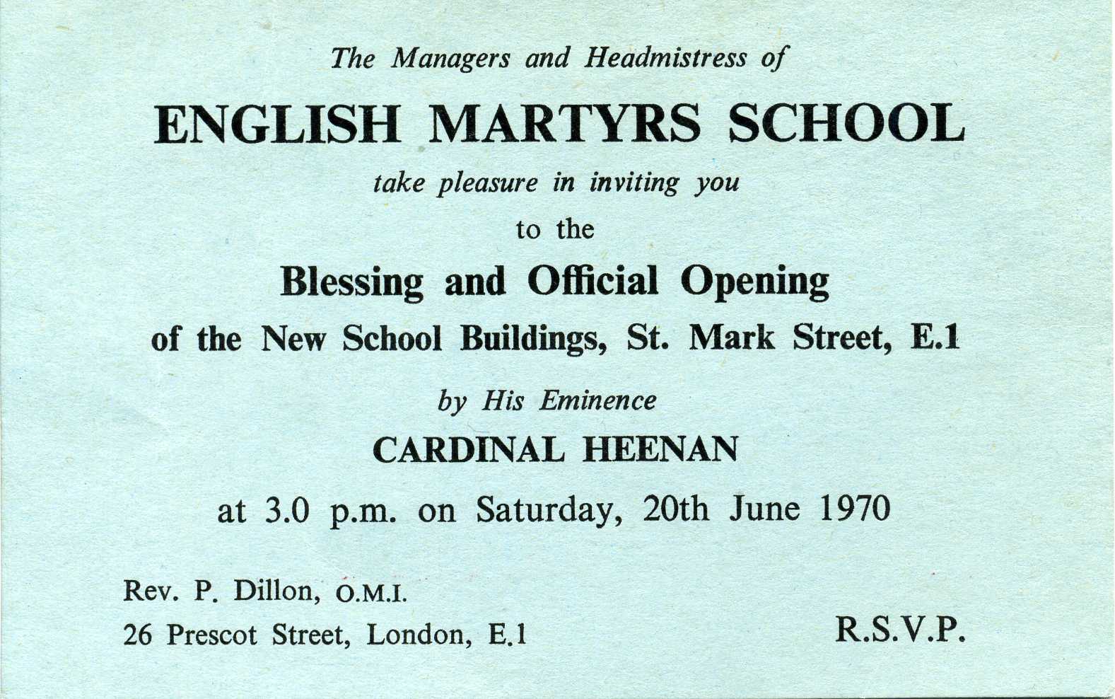
"title": "Invitation to the opening of English Martyrs' School, 1970",
"author": {
"id": 153,
"username": "danny"
},
"feature": {
"id": 95,
"type": "Feature",
"geometry": {
"type": "MultiPolygon",
"coordinates": [
[
[
[
-0.072288312836018,
51.512824307605015
],
[
-0.072121612943253,
51.512858159153865
],
[
-0.072025478409202,
51.512890409815434
],
[
-0.072011859946938,
51.51286535896135
],
[
-0.071966433437302,
51.51287497358547
],
[
-0.071934030456307,
51.51281536880901
],
[
-0.071897041880432,
51.51282319750863
],
[
-0.071941565002123,
51.51290509717561
],
[
-0.071831416366548,
51.512942678785066
],
[
-0.071781735212569,
51.5128432447703
],
[
-0.071725521861399,
51.51285417962799
],
[
-0.07176487086724,
51.51293293466522
],
[
-0.071675647300703,
51.51295029074344
],
[
-0.071664919501195,
51.51292881954059
],
[
-0.071609406497337,
51.512939618081724
],
[
-0.071587377736956,
51.512895528347
],
[
-0.071612025842334,
51.512890733734274
],
[
-0.071602267132423,
51.512871202037054
],
[
-0.071638516898164,
51.51286415062836
],
[
-0.071631665323334,
51.51285043746628
],
[
-0.071520551906845,
51.51287205152489
],
[
-0.071479483670422,
51.51278985445861
],
[
-0.071510654926827,
51.51278379096125
],
[
-0.071493990169301,
51.51275043681792
],
[
-0.071398637684366,
51.51276898494904
],
[
-0.071377550943573,
51.51272678005531
],
[
-0.071560243982688,
51.512691242207104
],
[
-0.071533397485951,
51.51263750953841
],
[
-0.071453105482364,
51.51265312815549
],
[
-0.071420349396566,
51.51258756716799
],
[
-0.07167247628417,
51.51253852254618
],
[
-0.071707184439989,
51.512607989805105
],
[
-0.071606228537011,
51.51262762818665
],
[
-0.071633225247965,
51.51268166132723
],
[
-0.07169132093397,
51.512670360313905
],
[
-0.071712967532689,
51.512713685153294
],
[
-0.071811121682106,
51.5126945917228
],
[
-0.071768019434541,
51.512608324512954
],
[
-0.071970981647633,
51.512568842989026
],
[
-0.072017837645733,
51.51266262230734
],
[
-0.071954707384708,
51.51267490286048
],
[
-0.072013765441807,
51.5127931035959
],
[
-0.072057545202814,
51.51278458724506
],
[
-0.072087040272971,
51.512843619299026
],
[
-0.072110299177035,
51.51283569768739
],
[
-0.072067753844785,
51.51274483657161
],
[
-0.072241827775471,
51.51271310224785
],
[
-0.072288312836018,
51.512824307605015
]
]
]
]
},
"properties": {
"b_number": "",
"b_name": "",
"street": "St Mark Street",
"address": "English Martyrs RC Primary School, St Mark Street",
"feature_type": "WHITECHAPEL_BUILDING",
"count": 9,
"search_str": "English Martyrs RC Primary School, St Mark Street"
},
"tags": []
},
"file": "https://surveyoflondon.org/media/uploads/features/95/School%20opening%20Invitation.jpg",
"description": "This was the invitation sent out by the Governors and Headmistress (Sr Marie Therese) welcoming people to the opening of the new school buildings of English Martyrs School by His Eminence Cardinal Heenan, the Primate of England and Wales for the Catholic Church. The school had moved from its former, and original building in Chamber Street, behind the Church of the English Martyrs and which I attended until the opening of the new school. The opening ceremony was held on Saturday 20th June 1970. The Parish Priest named on the invitation card, Fr P Dillon, is still working as a priest today - a member of the Oblates of Mary Immaculate (OMI) where he continues to lead fundraising for the Oblates' Overseas Missions. \n\nAt the time of the school opening, Sr Marie Therese lived with other members of her congregation in a house close to the Church in Prescot Street.\n\n",
"copyright": false,
"created": "2018-03-04"
},
{
"id": 1700,
"title": "The old rag and bone merchant's house",
"author": {
"id": 153,
"username": "danny"
},
"feature": {
"id": 1300,
"type": "Feature",
"geometry": {
"type": "MultiPolygon",
"coordinates": [
[
[
[
-0.072018212922805,
51.51147628030763
],
[
-0.072052072692605,
51.51156221854503
],
[
-0.072085986468046,
51.51155809766486
],
[
-0.072101265381627,
51.51159577638534
],
[
-0.072127686647318,
51.511591532313886
],
[
-0.072290889738566,
51.51172170278547
],
[
-0.072119151026891,
51.51174928937695
],
[
-0.072122403786088,
51.51176103895535
],
[
-0.072105446824984,
51.5117630994011
],
[
-0.072108304763041,
51.51178419937112
],
[
-0.071885842818874,
51.51181446054336
],
[
-0.071879189342706,
51.511794467771026
],
[
-0.071847148514896,
51.51179861938816
],
[
-0.071855625760368,
51.51181981175974
],
[
-0.071361209248715,
51.511898232521865
],
[
-0.071350859076592,
51.51187700931015
],
[
-0.071307529911615,
51.511882144735054
],
[
-0.071317781319065,
51.51190570554704
],
[
-0.071085755053542,
51.511940486344606
],
[
-0.071075306243067,
51.51192160070628
],
[
-0.070964099345331,
51.51193614595924
],
[
-0.070906585311218,
51.51178899853778
],
[
-0.070963125166791,
51.51178174135644
],
[
-0.070944397155318,
51.51173698808256
],
[
-0.070980233670712,
51.511731729539896
],
[
-0.070948150179626,
51.51164815942462
],
[
-0.071216011443844,
51.51160812026722
],
[
-0.071244694749225,
51.51168344710922
],
[
-0.071271066766769,
51.51168037203055
],
[
-0.071247657198011,
51.51161331920844
],
[
-0.071713727035037,
51.5115402808737
],
[
-0.071737334702225,
51.51160265841552
],
[
-0.071769326040543,
51.511599675625625
],
[
-0.071738916869541,
51.51152081170581
],
[
-0.072018212922805,
51.51147628030763
]
]
]
]
},
"properties": {
"b_number": "45",
"b_name": "",
"street": "Prescot Street",
"address": "Leonardo Royal Hotel Tower Bridge, 45 Prescot Street",
"feature_type": "WHITECHAPEL_BUILDING",
"count": 4,
"search_str": "Leonardo Royal Hotel Tower Bridge, 45 Prescot Street"
},
"tags": []
},
"file": "https://surveyoflondon.org/media/uploads/features/1300/Rag%20and%20Bone%20Prescot.jpg",
"description": "This is the rear of perhaps the last house left standing on the north side of Prescot Street by the 1980s. As a kid, in the sixties, I remember it was occupied by a man who sold old rags and clothing. One day, I was with my dad passing by, and the guy invited us to have a look around. It was dark and wrecked looking inside, but I spotted a London Fireman's helmet in the corner which he said I could take. It was a treasured piece in our home for many years and may still be be around.",
"copyright": false,
"created": "2020-05-12"
},
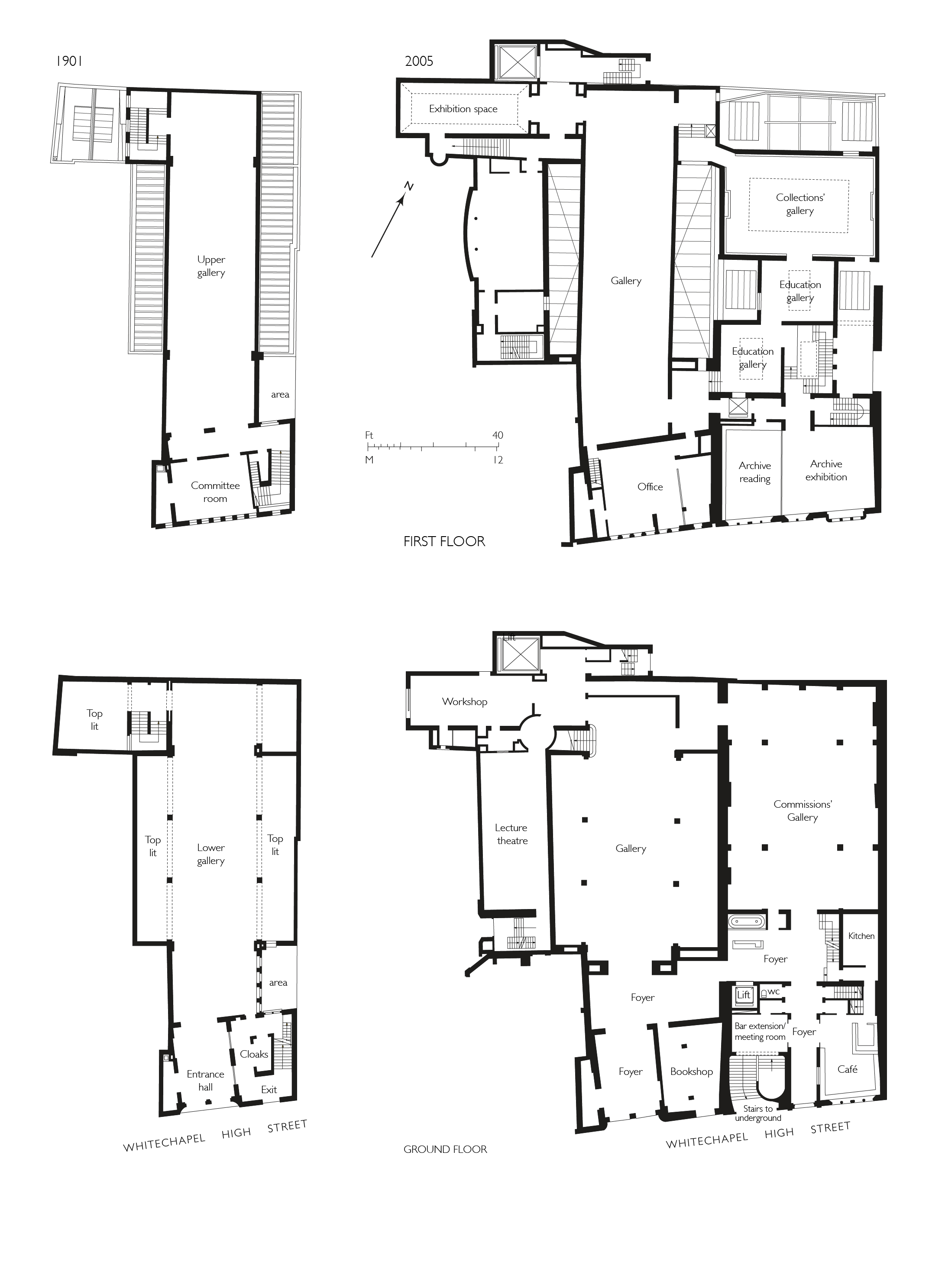
{
"id": 1776,
"title": "Whitechapel Gallery, ground- and first-floor plans, as built in 1898–1901 and as enlarged and altered by 2009",
"author": {
"id": 2,
"username": "surveyoflondon"
},
"feature": {
"id": 388,
"type": "Feature",
"geometry": {
"type": "MultiPolygon",
"coordinates": [
[
[
[
-0.070444999065034,
51.516268747815374
],
[
-0.070444987924411,
51.51626873485329
],
[
-0.070191183413983,
51.515943931980686
],
[
-0.07030660834808,
51.51590379026539
],
[
-0.070366244631028,
51.515976197771835
],
[
-0.070382361693267,
51.515991401135054
],
[
-0.070520839263358,
51.51595250664741
],
[
-0.070554830739485,
51.51599269532529
],
[
-0.070536539383068,
51.51600061037052
],
[
-0.070670856421127,
51.51616489931219
],
[
-0.070742289448097,
51.51614590797361
],
[
-0.070776212105595,
51.51618683122123
],
[
-0.070667546631979,
51.51621488771394
],
[
-0.070691375516433,
51.5162459029802
],
[
-0.070587290171224,
51.51627187207374
],
[
-0.070551087840537,
51.51627061113889
],
[
-0.07048764157752,
51.51628876524349
],
[
-0.070470164368826,
51.516262702692195
],
[
-0.070444999076386,
51.51626873811411
],
[
-0.070444999065034,
51.516268747815374
]
]
]
]
},
"properties": {
"b_number": "77–82",
"b_name": "Whitechapel Gallery, 77–82 Whitechapel High Street",
"street": "Whitechapel High Street",
"address": " 77–82 Whitechapel High Street",
"feature_type": "WHITECHAPEL_BUILDING",
"count": 13,
"search_str": "Whitechapel Gallery, 77–82 Whitechapel High Street"
},
"tags": []
},
"file": "https://surveyoflondon.org/media/uploads/features/388/Whitechapel%20Picture%20Gllery%20multi%20floors%20new%201.jpg",
"description": "Drawn by Helen Jones for the Survey of London based on archive sources",
"copyright": true,
"created": "2020-09-14"
},
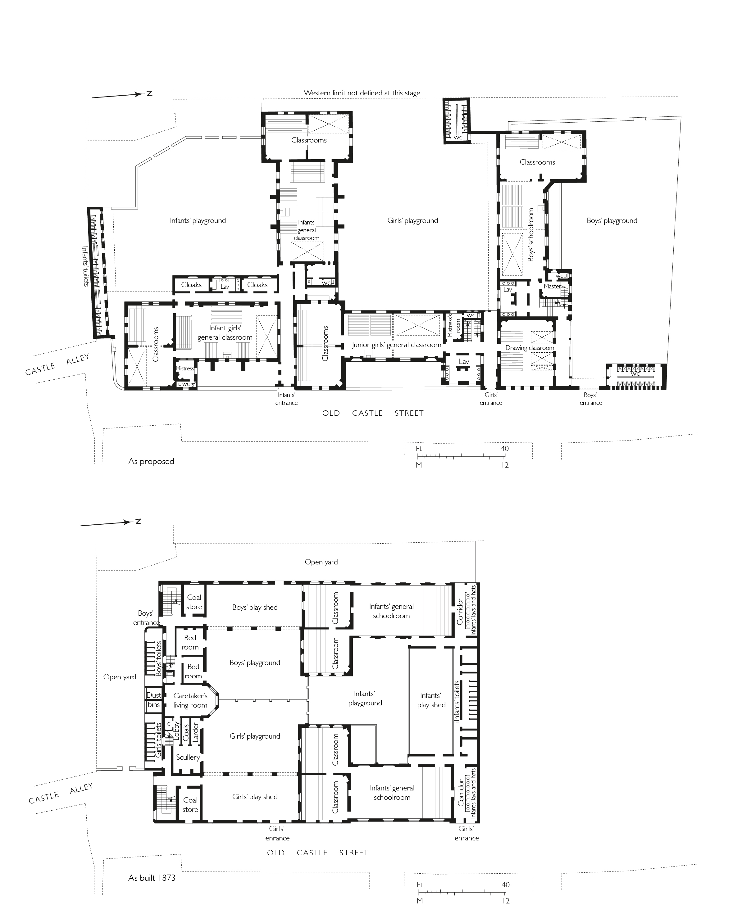
{
"id": 1775,
"title": "Old Castle Street School, ground-floor plan as proposed in 1870 and as built in 1873, drawing by Helen Jones",
"author": {
"id": 2,
"username": "surveyoflondon"
},
"feature": {
"id": 355,
"type": "Feature",
"geometry": {
"type": "MultiPolygon",
"coordinates": [
[
[
[
-0.074471609124608,
51.516157394230596
],
[
-0.074094924476241,
51.51627050128873
],
[
-0.07389322310185,
51.51601309694218
],
[
-0.074264013012644,
51.515898564190884
],
[
-0.074337530456423,
51.51598441114345
],
[
-0.074271504609232,
51.516006422063526
],
[
-0.074251298845097,
51.51598282761466
],
[
-0.074049011165702,
51.51605026352619
],
[
-0.074144047562767,
51.516169151315886
],
[
-0.074359544442729,
51.51610517582989
],
[
-0.074351750936823,
51.51609801971847
],
[
-0.07440543525088,
51.51608012306834
],
[
-0.074471609124608,
51.516157394230596
]
]
]
]
},
"properties": {
"b_number": "",
"b_name": "Herbert House",
"street": "Old Castle Street",
"address": "Herbert House, Old Castle Street, London E1 7TW",
"feature_type": "WHITECHAPEL_BUILDING",
"count": 8,
"search_str": "Herbert House"
},
"tags": []
},
"file": "https://surveyoflondon.org/media/uploads/features/355/Old%20castle%20street%20school%20both%20final%20final.jpg",
"description": "",
"copyright": true,
"created": "2020-09-14"
},
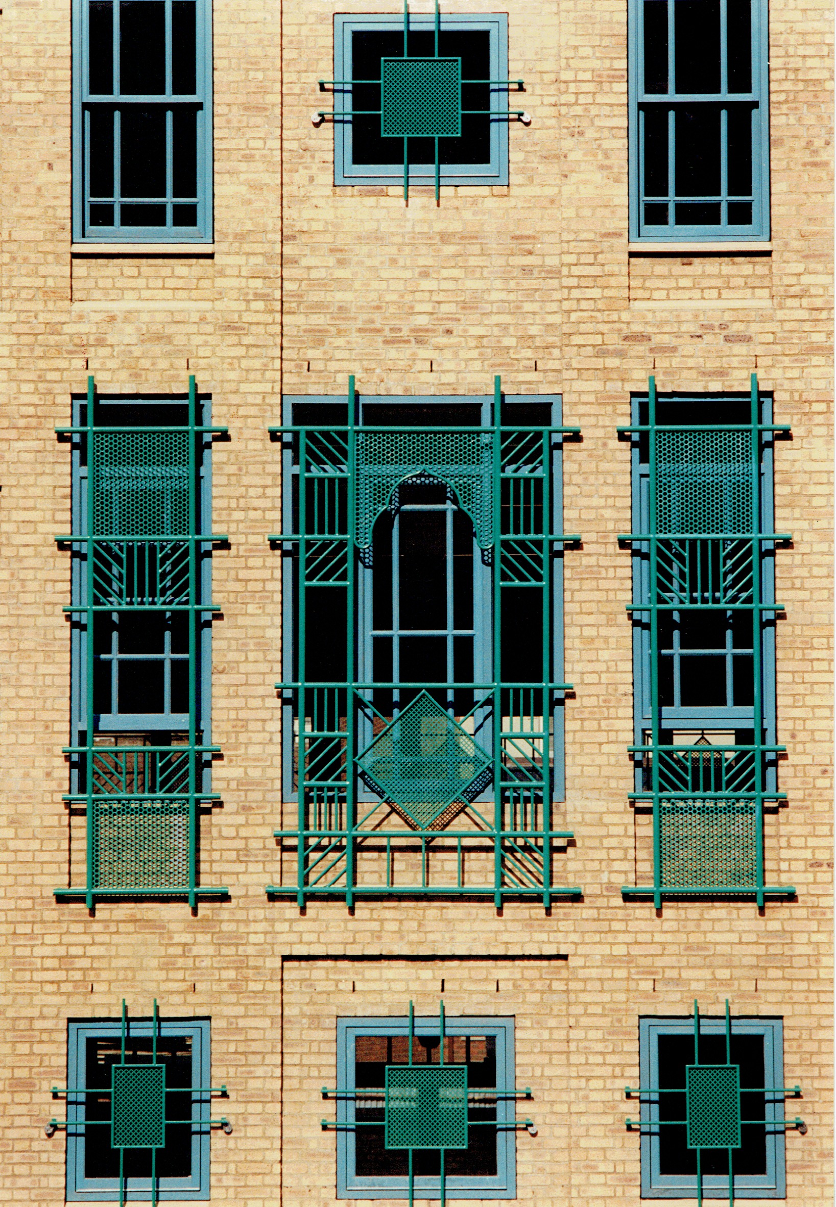
{
"id": 945,
"title": "Front elevation window screens ",
"author": {
"id": 18,
"username": "shahedsaleem"
},
"feature": {
"id": 453,
"type": "Feature",
"geometry": {
"type": "MultiPolygon",
"coordinates": [
[
[
[
-0.06387175509906,
51.51844488660313
],
[
-0.063674757657848,
51.51849920648765
],
[
-0.063594819394982,
51.5183863647881
],
[
-0.063789009522268,
51.51833442643744
],
[
-0.06387175509906,
51.51844488660313
]
]
]
]
},
"properties": {
"b_number": "183-185",
"b_name": "Former Jagonari Women's Centre, 183-185 Whitechapel Road",
"street": "Whitechapel Road",
"address": "183-185 Whitechapel Road",
"feature_type": "WHITECHAPEL_BUILDING",
"count": 15,
"search_str": "Former Jagonari Women's Centre, 183-185 Whitechapel Road"
},
"tags": [
"GLC",
"Jagonari",
"Matrix",
"nursery"
]
},
"file": "https://surveyoflondon.org/media/uploads/features/453/Jag%20Front%20!987.jpeg",
"description": "A photograph from 1987 showing the decorative and security screening on the front elevation windows of the Jagonari Centre\n(Image courtesy of Anne Thorne)",
"copyright": false,
"created": "2017-10-24"
},
{
"id": 932,
"title": "The Roman road through Whitechapel",
"author": {
"id": 199,
"username": "markwillingale"
},
"feature": {
"id": 296,
"type": "Feature",
"geometry": {
"type": "MultiPolygon",
"coordinates": [
[
[
[
-0.069238538289603,
51.51610506120929
],
[
-0.069007097235987,
51.5162239535272
],
[
-0.068282200256798,
51.51654369745104
],
[
-0.068157401560378,
51.51641994527148
],
[
-0.067807959279103,
51.51600137496063
],
[
-0.068541180339468,
51.515783257348254
],
[
-0.068555919008956,
51.51580580160597
],
[
-0.068713893455475,
51.515872451567986
],
[
-0.068778503699218,
51.51586114158782
],
[
-0.068817146392177,
51.515922550138725
],
[
-0.068888047037903,
51.51596428315636
],
[
-0.069016085124709,
51.515921053627785
],
[
-0.069107698271647,
51.51601562404751
],
[
-0.069243279190738,
51.515974904669626
],
[
-0.069238538289603,
51.51610506120929
]
]
]
]
},
"properties": {
"b_number": "",
"b_name": "Altab Ali Park, including the site of the parish church of St Mary Matfelon",
"street": "Whitechapel Road",
"address": "Altab Ali Park",
"feature_type": "OPEN_SPACE",
"count": 32,
"search_str": "Altab Ali Park, including the site of the parish church of St Mary Matfelon"
},
"tags": []
},
"file": "https://surveyoflondon.org/media/uploads/features/296/RomanRoad_Whitechapel.jpg",
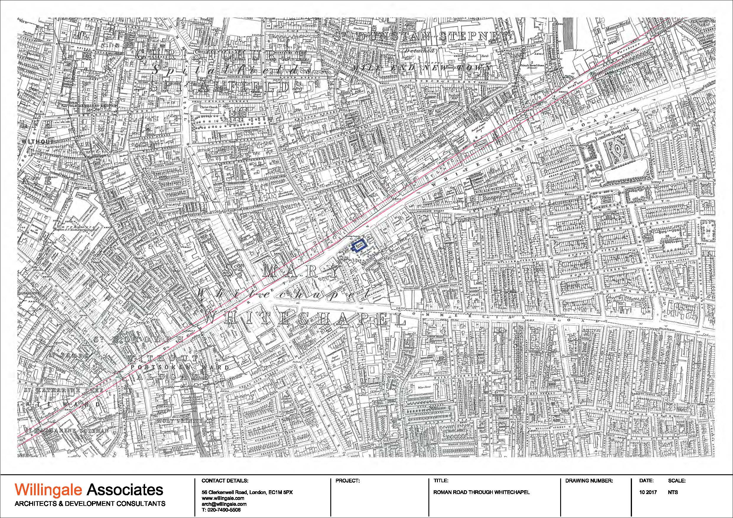
"description": "The red lines on this map indicate the route of the Roman road described as Ley Street in the account titled 'Ley Street and Queen Matilda's 12th-century Bypass' under the research tab.",
"copyright": true,
"created": "2017-10-13"
},
{
"id": 1774,
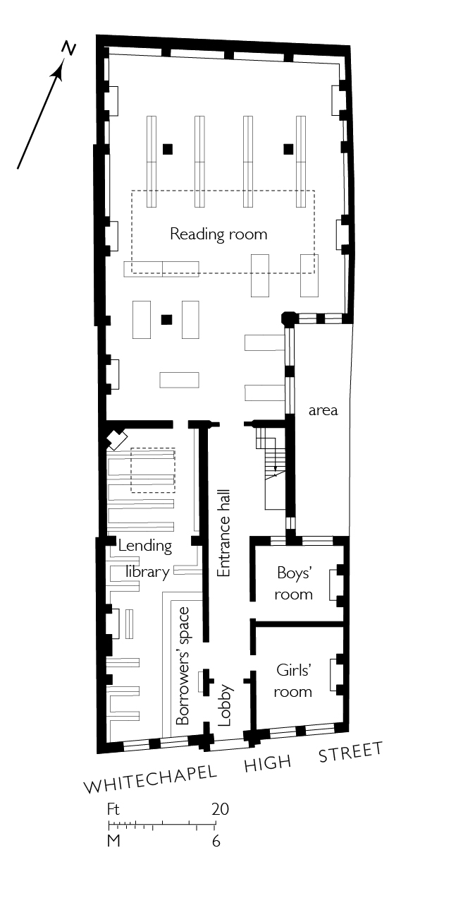
"title": "Whitechapel Library, ground-floor plan as built in 1892, drawing by Helen Jones based on archive sources",
"author": {
"id": 2,
"username": "surveyoflondon"
},
"feature": {
"id": 396,
"type": "Feature",
"geometry": {
"type": "MultiPolygon",
"coordinates": [
[
[
[
-0.070191183413983,
51.515943931980686
],
[
-0.070444987924411,
51.51626873485329
],
[
-0.070444999065034,
51.516268747815374
],
[
-0.070444964983339,
51.51629786697601
],
[
-0.070200105619136,
51.51635712000048
],
[
-0.07018112057321,
51.516332236247315
],
[
-0.070199532030395,
51.51632669238655
],
[
-0.070111165185554,
51.516203386086495
],
[
-0.070156100285004,
51.516193027992266
],
[
-0.070080484659871,
51.51609939740674
],
[
-0.070055650302787,
51.51610727770941
],
[
-0.070049788081592,
51.51609931840464
],
[
-0.06997681153841,
51.51601296679346
],
[
-0.07015396692832,
51.51595688181036
],
[
-0.070153962516368,
51.5159568764167
],
[
-0.070191183413983,
51.515943931980686
]
]
]
]
},
"properties": {
"b_number": "77-82",
"b_name": "Whitechapel Gallery, former Whitechapel Library",
"street": "Whitechapel High Street",
"address": "77-82 Whitechapel High Street",
"feature_type": "WHITECHAPEL_BUILDING",
"count": 9,
"search_str": "Whitechapel Gallery, former Whitechapel Library"
},
"tags": [
"art",
"gallery"
]
},
"file": "https://surveyoflondon.org/media/uploads/features/396/Whitechapel%20library%20final.jpg",
"description": "",
"copyright": true,
"created": "2020-09-09"
},
{
"id": 1773,
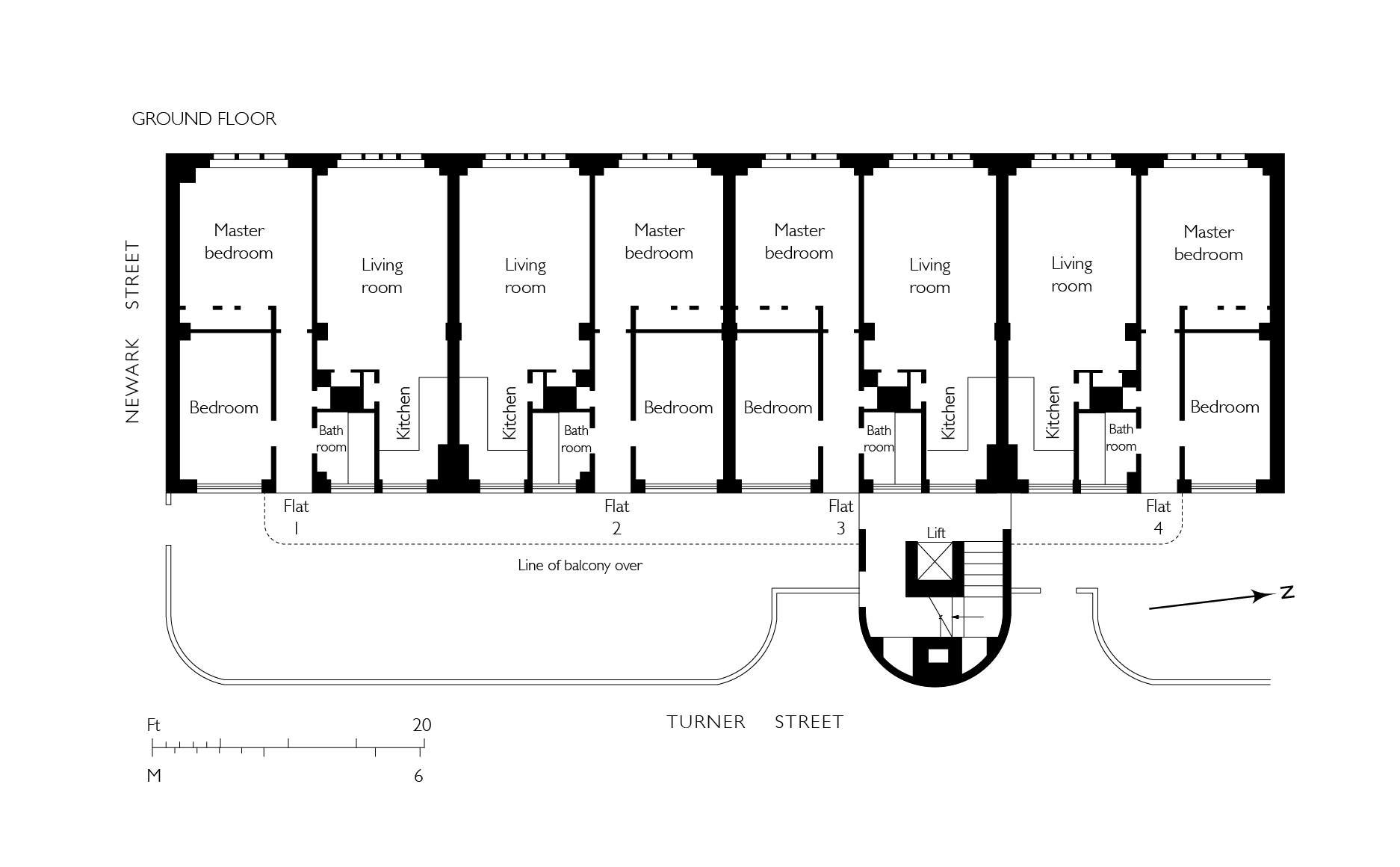
"title": "Gwynne House, ground-floor plan, drawing by Helen Jones based on archive sources",
"author": {
"id": 2,
"username": "surveyoflondon"
},
"feature": {
"id": 1167,
"type": "Feature",
"geometry": {
"type": "MultiPolygon",
"coordinates": [
[
[
[
-0.061202658412951,
51.51719574435803
],
[
-0.061079306347624,
51.517207329101645
],
[
-0.061069199583201,
51.51716543919934
],
[
-0.06101193415403,
51.517170817215984
],
[
-0.061003155763681,
51.51716934564466
],
[
-0.060996103082444,
51.51716563437471
],
[
-0.060993244898833,
51.51716109482402
],
[
-0.060992481314744,
51.51715643997487
],
[
-0.060993400756275,
51.517151902171804
],
[
-0.06099534354228,
51.51714833843544
],
[
-0.060997956097902,
51.51714503825175
],
[
-0.061004341447847,
51.51714210593221
],
[
-0.061009647790809,
51.517139669120326
],
[
-0.061022544587713,
51.517137757001514
],
[
-0.061059918868378,
51.517132215801325
],
[
-0.061029644233656,
51.516996130234475
],
[
-0.061156522910844,
51.51698514293202
],
[
-0.061202658412951,
51.51719574435803
]
]
]
]
},
"properties": {
"b_number": "",
"b_name": "",
"street": "Turner Street",
"address": "Gwynne House",
"feature_type": "WHITECHAPEL_BUILDING",
"count": 7,
"search_str": "Gwynne House"
},
"tags": []
},
"file": "https://surveyoflondon.org/media/uploads/features/1167/Gwyne%20House%20flat%20plan%20final%201.jpg",
"description": "",
"copyright": true,
"created": "2020-09-09"
},
{
"id": 1530,
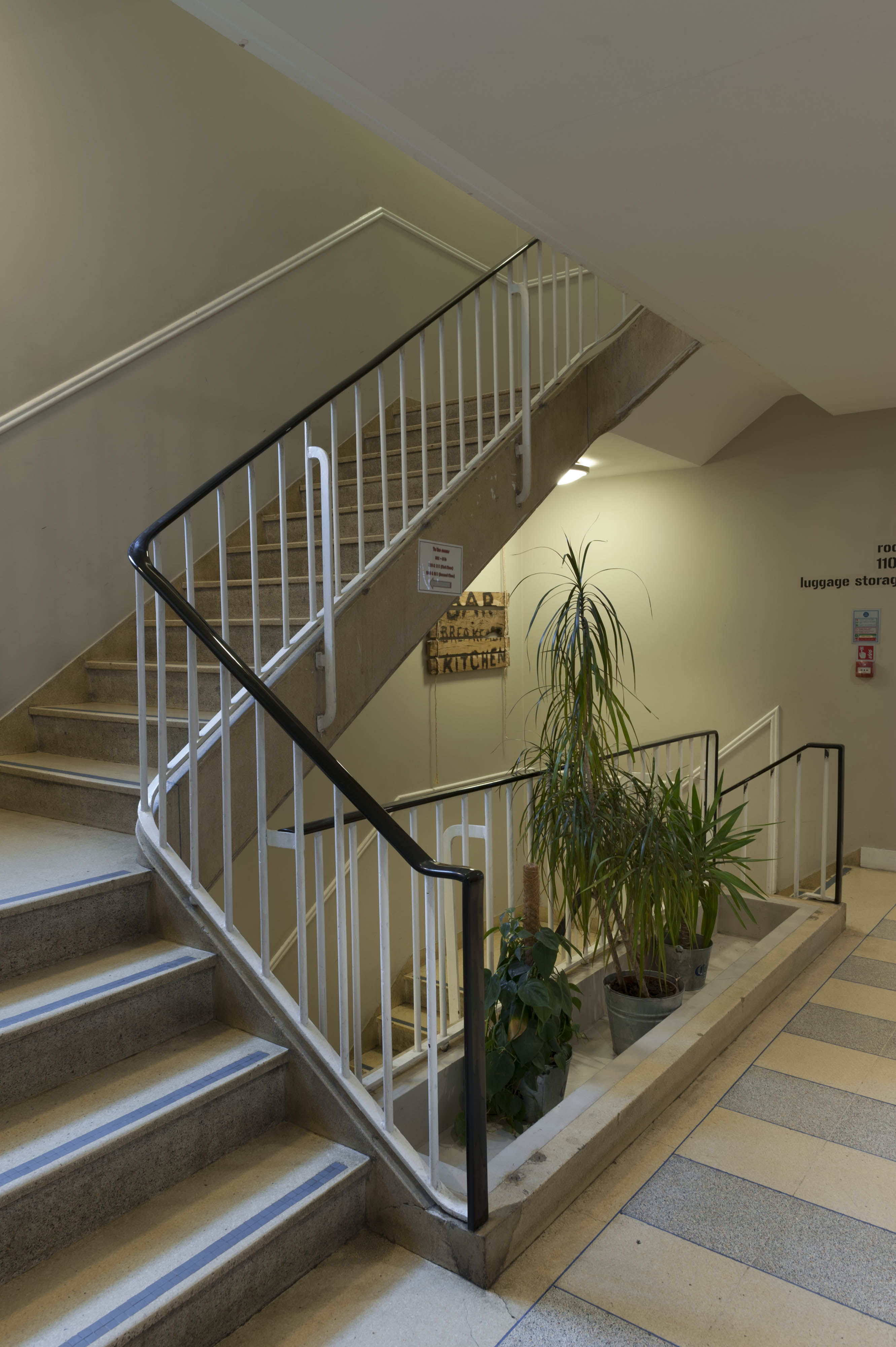
"title": "Wombat's, 1950s staircase from the northeast in 2019",
"author": {
"id": 27,
"username": "DerekKendall"
},
"feature": {
"id": 1385,
"type": "Feature",
"geometry": {
"type": "MultiPolygon",
"coordinates": [
[
[
[
-0.067575803709333,
51.51021492278667
],
[
-0.067783647338447,
51.51017527172947
],
[
-0.067828706900756,
51.510167293395675
],
[
-0.067884358000762,
51.51028332470727
],
[
-0.068021222270461,
51.51026117174896
],
[
-0.068027105232624,
51.51027869995762
],
[
-0.068059007104689,
51.51027341168682
],
[
-0.068045803249401,
51.51025517119752
],
[
-0.068185711037114,
51.51022956959143
],
[
-0.068302205657116,
51.51049311218949
],
[
-0.068154065018083,
51.51051508999573
],
[
-0.068142111677326,
51.51048931210634
],
[
-0.068158013519995,
51.51048782991857
],
[
-0.0680993992664,
51.51035372697415
],
[
-0.068063773094401,
51.51035895389879
],
[
-0.068055396596396,
51.510336723241444
],
[
-0.067963562571312,
51.510349163498944
],
[
-0.067961653646245,
51.510339150568754
],
[
-0.067909585576321,
51.510347692789416
],
[
-0.067933270683552,
51.5104044774377
],
[
-0.067674158297256,
51.51045078856997
],
[
-0.067629160671485,
51.51036923447038
],
[
-0.067652633918951,
51.51036497018876
],
[
-0.067575803709333,
51.51021492278667
]
]
]
]
},
"properties": {
"b_number": "7",
"b_name": "",
"street": "Dock Street",
"address": "Wombat's City Hostel, 7 Dock Street",
"feature_type": "WHITECHAPEL_BUILDING",
"count": 25,
"search_str": "Wombat's City Hostel, 7 Dock Street"
},
"tags": []
},
"file": "https://surveyoflondon.org/media/uploads/features/1385/SoL%20Whitechapel%20102615.jpg",
"description": "",
"copyright": true,
"created": "2019-03-05"
},
{
"id": 1531,
"title": "Wombat's, internal courtyard from the north in 2019",
"author": {
"id": 27,
"username": "DerekKendall"
},
"feature": {
"id": 1385,
"type": "Feature",
"geometry": {
"type": "MultiPolygon",
"coordinates": [
[
[
[
-0.067575803709333,
51.51021492278667
],
[
-0.067783647338447,
51.51017527172947
],
[
-0.067828706900756,
51.510167293395675
],
[
-0.067884358000762,
51.51028332470727
],
[
-0.068021222270461,
51.51026117174896
],
[
-0.068027105232624,
51.51027869995762
],
[
-0.068059007104689,
51.51027341168682
],
[
-0.068045803249401,
51.51025517119752
],
[
-0.068185711037114,
51.51022956959143
],
[
-0.068302205657116,
51.51049311218949
],
[
-0.068154065018083,
51.51051508999573
],
[
-0.068142111677326,
51.51048931210634
],
[
-0.068158013519995,
51.51048782991857
],
[
-0.0680993992664,
51.51035372697415
],
[
-0.068063773094401,
51.51035895389879
],
[
-0.068055396596396,
51.510336723241444
],
[
-0.067963562571312,
51.510349163498944
],
[
-0.067961653646245,
51.510339150568754
],
[
-0.067909585576321,
51.510347692789416
],
[
-0.067933270683552,
51.5104044774377
],
[
-0.067674158297256,
51.51045078856997
],
[
-0.067629160671485,
51.51036923447038
],
[
-0.067652633918951,
51.51036497018876
],
[
-0.067575803709333,
51.51021492278667
]
]
]
]
},
"properties": {
"b_number": "7",
"b_name": "",
"street": "Dock Street",
"address": "Wombat's City Hostel, 7 Dock Street",
"feature_type": "WHITECHAPEL_BUILDING",
"count": 25,
"search_str": "Wombat's City Hostel, 7 Dock Street"
},
"tags": []
},
"file": "https://surveyoflondon.org/media/uploads/features/1385/SoL%20Whitechapel%20102617.jpg",
"description": "",
"copyright": true,
"created": "2019-03-05"
},
{
"id": 1532,
"title": "Wombat's, basement bar with vaults from the 1830s, in 2019",
"author": {
"id": 27,
"username": "DerekKendall"
},
"feature": {
"id": 1385,
"type": "Feature",
"geometry": {
"type": "MultiPolygon",
"coordinates": [
[
[
[
-0.067575803709333,
51.51021492278667
],
[
-0.067783647338447,
51.51017527172947
],
[
-0.067828706900756,
51.510167293395675
],
[
-0.067884358000762,
51.51028332470727
],
[
-0.068021222270461,
51.51026117174896
],
[
-0.068027105232624,
51.51027869995762
],
[
-0.068059007104689,
51.51027341168682
],
[
-0.068045803249401,
51.51025517119752
],
[
-0.068185711037114,
51.51022956959143
],
[
-0.068302205657116,
51.51049311218949
],
[
-0.068154065018083,
51.51051508999573
],
[
-0.068142111677326,
51.51048931210634
],
[
-0.068158013519995,
51.51048782991857
],
[
-0.0680993992664,
51.51035372697415
],
[
-0.068063773094401,
51.51035895389879
],
[
-0.068055396596396,
51.510336723241444
],
[
-0.067963562571312,
51.510349163498944
],
[
-0.067961653646245,
51.510339150568754
],
[
-0.067909585576321,
51.510347692789416
],
[
-0.067933270683552,
51.5104044774377
],
[
-0.067674158297256,
51.51045078856997
],
[
-0.067629160671485,
51.51036923447038
],
[
-0.067652633918951,
51.51036497018876
],
[
-0.067575803709333,
51.51021492278667
]
]
]
]
},
"properties": {
"b_number": "7",
"b_name": "",
"street": "Dock Street",
"address": "Wombat's City Hostel, 7 Dock Street",
"feature_type": "WHITECHAPEL_BUILDING",
"count": 25,
"search_str": "Wombat's City Hostel, 7 Dock Street"
},
"tags": []
},
"file": "https://surveyoflondon.org/media/uploads/features/1385/SoL%20Whitechapel%20102619.jpg",
"description": "",
"copyright": true,
"created": "2019-03-05"
},
{
"id": 1533,
"title": "Wombat's, basement bar with vaults from the 1830s, in 2019",
"author": {
"id": 27,
"username": "DerekKendall"
},
"feature": {
"id": 1385,
"type": "Feature",
"geometry": {
"type": "MultiPolygon",
"coordinates": [
[
[
[
-0.067575803709333,
51.51021492278667
],
[
-0.067783647338447,
51.51017527172947
],
[
-0.067828706900756,
51.510167293395675
],
[
-0.067884358000762,
51.51028332470727
],
[
-0.068021222270461,
51.51026117174896
],
[
-0.068027105232624,
51.51027869995762
],
[
-0.068059007104689,
51.51027341168682
],
[
-0.068045803249401,
51.51025517119752
],
[
-0.068185711037114,
51.51022956959143
],
[
-0.068302205657116,
51.51049311218949
],
[
-0.068154065018083,
51.51051508999573
],
[
-0.068142111677326,
51.51048931210634
],
[
-0.068158013519995,
51.51048782991857
],
[
-0.0680993992664,
51.51035372697415
],
[
-0.068063773094401,
51.51035895389879
],
[
-0.068055396596396,
51.510336723241444
],
[
-0.067963562571312,
51.510349163498944
],
[
-0.067961653646245,
51.510339150568754
],
[
-0.067909585576321,
51.510347692789416
],
[
-0.067933270683552,
51.5104044774377
],
[
-0.067674158297256,
51.51045078856997
],
[
-0.067629160671485,
51.51036923447038
],
[
-0.067652633918951,
51.51036497018876
],
[
-0.067575803709333,
51.51021492278667
]
]
]
]
},
"properties": {
"b_number": "7",
"b_name": "",
"street": "Dock Street",
"address": "Wombat's City Hostel, 7 Dock Street",
"feature_type": "WHITECHAPEL_BUILDING",
"count": 25,
"search_str": "Wombat's City Hostel, 7 Dock Street"
},
"tags": []
},
"file": "https://surveyoflondon.org/media/uploads/features/1385/SoL%20Whitechapel%20102622.jpg",
"description": "",
"copyright": true,
"created": "2019-03-05"
},
{
"id": 1798,
"title": "Women's Library, ground-floor plan in 2012 - drawing by Helen Jones",
"author": {
"id": 2,
"username": "surveyoflondon"
},
"feature": {
"id": 1447,
"type": "Feature",
"geometry": {
"type": "MultiPolygon",
"coordinates": [
[
[
[
-0.073620345272929,
51.51568885255038
],
[
-0.073978291920849,
51.515581075868006
],
[
-0.074105154053684,
51.51572542989613
],
[
-0.073829058934223,
51.51581988475423
],
[
-0.073816416255057,
51.51580549883457
],
[
-0.073765536685163,
51.515822645959325
],
[
-0.073818338832879,
51.51587274604106
],
[
-0.073896057393162,
51.515850404112115
],
[
-0.073900642179228,
51.51585546922409
],
[
-0.073811510459007,
51.51588294615875
],
[
-0.073751379811388,
51.51582774828753
],
[
-0.073609777363084,
51.515693181519985
],
[
-0.073620345272929,
51.51568885255038
]
]
]
]
},
"properties": {
"b_number": "25",
"b_name": "The Wash Houses, London Metropolitan University, former Whitechapel Baths",
"street": "Old Castle Street",
"address": "The Wash Houses, London Metropolitan Univeristy, 25 Old Castle Street, London E1 7NT",
"feature_type": "WHITECHAPEL_BUILDING",
"count": 19,
"search_str": "The Wash Houses, London Metropolitan University, former Whitechapel Baths"
},
"tags": [
"cholera",
"library",
"swimming",
"washing",
"women"
]
},
"file": "https://surveyoflondon.org/media/uploads/features/1447/womens%20library%201%20final.jpg",
"description": "",
"copyright": true,
"created": "2021-02-10"
}
]
}