HTTP 200 OK
Allow: GET, HEAD, OPTIONS
Content-Type: application/json
Vary: Accept
{
"count": 1747,
"next": "https://surveyoflondon.org/api/v1/images/?format=api&page=82",
"previous": "https://surveyoflondon.org/api/v1/images/?format=api&page=80",
"results": [
{
"id": 1728,
"title": "66 Alie Street from the north-east in 2019",
"author": {
"id": 27,
"username": "DerekKendall"
},
"feature": {
"id": 1047,
"type": "Feature",
"geometry": {
"type": "MultiPolygon",
"coordinates": [
[
[
[
-0.070507285693422,
51.51383090440113
],
[
-0.069707737237537,
51.514184751452724
],
[
-0.069322145577777,
51.513819239326324
],
[
-0.069477910961367,
51.5137516492373
],
[
-0.069449902184866,
51.51371686688633
],
[
-0.069614131036717,
51.513655768609844
],
[
-0.069648590074739,
51.51369101943822
],
[
-0.070222944111541,
51.513488026703634
],
[
-0.070278058062727,
51.513554501477984
],
[
-0.070306902534867,
51.51354356766092
],
[
-0.070379446811545,
51.513631553258705
],
[
-0.070350540554201,
51.51364190115836
],
[
-0.070507285693422,
51.51383090440113
]
]
]
]
},
"properties": {
"b_number": "66",
"b_name": "Premier Inn, 66 Alie Street",
"street": "Alie Street",
"address": "Premier Inn, 66 Alie Street",
"feature_type": "WHITECHAPEL_BUILDING",
"count": 14,
"search_str": "Premier Inn, 66 Alie Street"
},
"tags": []
},
"file": "https://surveyoflondon.org/media/uploads/features/1047/SoL%20Whitechapel%20102700.jpg",
"description": "",
"copyright": true,
"created": "2020-06-05"
},
{
"id": 1729,
"title": "East Tenter Street's north end from the west in 2019",
"author": {
"id": 27,
"username": "DerekKendall"
},
"feature": {
"id": 84,
"type": "Feature",
"geometry": {
"type": "MultiPolygon",
"coordinates": [
[
[
[
-0.070763717870626,
51.51334409604028
],
[
-0.070895955764152,
51.513303113443875
],
[
-0.070934641607379,
51.51334963856506
],
[
-0.070799808107294,
51.51339053654499
],
[
-0.070763717870626,
51.51334409604028
]
]
]
]
},
"properties": {
"b_number": "30",
"b_name": "",
"street": "East Tenter Street",
"address": "30 East Tenter Street",
"feature_type": "WHITECHAPEL_BUILDING",
"count": 4,
"search_str": "30 East Tenter Street"
},
"tags": [
"builder",
"Davis brothers",
"East Tenter Street",
"Leman Street",
"Nathaniel Davis",
"Raphael Davis"
]
},
"file": "https://surveyoflondon.org/media/uploads/features/84/SoL%20Whitechapel%20102704.jpg",
"description": "",
"copyright": true,
"created": "2020-06-05"
},
{
"id": 1770,
"title": "View to north along Gower's Walk showing Nos 47–59 in 2017",
"author": {
"id": 27,
"username": "DerekKendall"
},
"feature": {
"id": 999,
"type": "Feature",
"geometry": {
"type": "MultiPolygon",
"coordinates": [
[
[
[
-0.067750438366323,
51.513857416217355
],
[
-0.067654551224466,
51.51385792281936
],
[
-0.067601052660363,
51.51385773679006
],
[
-0.067601619574326,
51.51379167100992
],
[
-0.067739777424029,
51.51379325201753
],
[
-0.067750438366323,
51.513857416217355
]
]
]
]
},
"properties": {
"b_number": "48",
"b_name": "48 Gower's Walk",
"street": "Gower's Walk",
"address": "48 Gower's Walk",
"feature_type": "WHITECHAPEL_BUILDING",
"count": 3,
"search_str": "48 Gower's Walk"
},
"tags": []
},
"file": "https://surveyoflondon.org/media/uploads/features/999/SoL%20Whitechapel%20101070.jpg",
"description": "",
"copyright": true,
"created": "2020-08-04"
},
{
"id": 318,
"title": "New Goulston Street and 48-105 Davis Mansions, c. 1960 (see archive.HistoricEngland.org.uk)",
"author": {
"id": 25,
"username": "Aileen"
},
"feature": {
"id": 339,
"type": "Feature",
"geometry": {
"type": "MultiPolygon",
"coordinates": [
[
[
[
-0.075741721510932,
51.51597024544204
],
[
-0.075729129531496,
51.51597769919067
],
[
-0.075787749784253,
51.51605283056567
],
[
-0.075636361542524,
51.51612484259637
],
[
-0.075650175764429,
51.516148000033674
],
[
-0.075502354572925,
51.516191829982816
],
[
-0.075319288269354,
51.51625050513866
],
[
-0.075219099902158,
51.516131960701856
],
[
-0.075227548811708,
51.51609366049923
],
[
-0.075715602158458,
51.51594735701813
],
[
-0.075741721510932,
51.51597024544204
]
]
]
]
},
"properties": {
"b_number": "20-27",
"b_name": "20-27 Wentworth Dwellings",
"street": "New Goulston Street",
"address": "20-27 Wentworth Dwellings, New Goulston Street",
"feature_type": "WHITECHAPEL_BUILDING",
"count": 8,
"search_str": "20-27 Wentworth Dwellings"
},
"tags": []
},
"file": "https://surveyoflondon.org/media/uploads/features/339/aa099670.jpg",
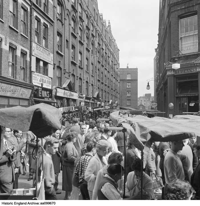
"description": "This view of Petticoat Lane market, which then spread eastwards from Middlesex Street along New Goulston Street, was taken by the photographer John Gay taken between 1957 and 1962. On the north side of New Goulston Street are visible two blocks of the 1894-5 development of Davis Mansions, built by Abraham Davis, second of the seven Davis brothers active in Whitechapel in the late 19th and early 20th centuries. Davis Mansions was one of several large developments of similar blocks by Abraham Davis in this part of Whitechapel and Spitalfields to the north. ",
"copyright": false,
"created": "2016-09-01"
},
{
"id": 1677,
"title": "Proving a Lee Enfield rifle in the proof house in 2018",
"author": {
"id": 27,
"username": "DerekKendall"
},
"feature": {
"id": 1016,
"type": "Feature",
"geometry": {
"type": "MultiPolygon",
"coordinates": [
[
[
[
-0.068260232398246,
51.51477078323367
],
[
-0.068015891167626,
51.5147824074063
],
[
-0.067989584029828,
51.514607222723676
],
[
-0.068165517221812,
51.5145962554253
],
[
-0.068167507270317,
51.51461124694583
],
[
-0.068237397616931,
51.5146070496752
],
[
-0.068260232398246,
51.51477078323367
]
],
[
[
-0.068202841801552,
51.51466683191732
],
[
-0.068136591673853,
51.51467046256953
],
[
-0.068144363769439,
51.51473136877517
],
[
-0.068208694296891,
51.51472806567735
],
[
-0.068202841801552,
51.51466683191732
]
],
[
[
-0.068088690886023,
51.514711682651345
],
[
-0.06808732190461,
51.51470153629181
],
[
-0.068009718204265,
51.51470567288329
],
[
-0.068011037313001,
51.51471548132591
],
[
-0.068088690886023,
51.514711682651345
]
]
]
]
},
"properties": {
"b_number": "48",
"b_name": "The Proof House, 48-50 Commercial Road",
"street": "Commercial Road",
"address": "Worshipful Company of Gunmakers, The Proof House, 48-50 Commercial Road",
"feature_type": "WHITECHAPEL_BUILDING",
"count": 15,
"search_str": "The Proof House, 48-50 Commercial Road"
},
"tags": []
},
"file": "https://surveyoflondon.org/media/uploads/features/1016/SoL%20Whitechapel%20102499.jpg",
"description": "",
"copyright": true,
"created": "2020-02-17"
},
{
"id": 1678,
"title": "Gunmakers' Company's proof house, workshop on south side of internal courtyard, view to the north in 2018",
"author": {
"id": 27,
"username": "DerekKendall"
},
"feature": {
"id": 1016,
"type": "Feature",
"geometry": {
"type": "MultiPolygon",
"coordinates": [
[
[
[
-0.068260232398246,
51.51477078323367
],
[
-0.068015891167626,
51.5147824074063
],
[
-0.067989584029828,
51.514607222723676
],
[
-0.068165517221812,
51.5145962554253
],
[
-0.068167507270317,
51.51461124694583
],
[
-0.068237397616931,
51.5146070496752
],
[
-0.068260232398246,
51.51477078323367
]
],
[
[
-0.068202841801552,
51.51466683191732
],
[
-0.068136591673853,
51.51467046256953
],
[
-0.068144363769439,
51.51473136877517
],
[
-0.068208694296891,
51.51472806567735
],
[
-0.068202841801552,
51.51466683191732
]
],
[
[
-0.068088690886023,
51.514711682651345
],
[
-0.06808732190461,
51.51470153629181
],
[
-0.068009718204265,
51.51470567288329
],
[
-0.068011037313001,
51.51471548132591
],
[
-0.068088690886023,
51.514711682651345
]
]
]
]
},
"properties": {
"b_number": "48",
"b_name": "The Proof House, 48-50 Commercial Road",
"street": "Commercial Road",
"address": "Worshipful Company of Gunmakers, The Proof House, 48-50 Commercial Road",
"feature_type": "WHITECHAPEL_BUILDING",
"count": 15,
"search_str": "The Proof House, 48-50 Commercial Road"
},
"tags": []
},
"file": "https://surveyoflondon.org/media/uploads/features/1016/SoL%20Whitechapel%20102516.jpg",
"description": "",
"copyright": true,
"created": "2020-02-17"
},
{
"id": 356,
"title": "1753 engraving by Chatelain & Toms after William Bellers view of a proposed building for the London Hospital",
"author": {
"id": 37,
"username": "HistoricEngland"
},
"feature": {
"id": 1230,
"type": "Feature",
"geometry": {
"type": "MultiPolygon",
"coordinates": [
[
[
[
-0.06071898744648,
51.51847914149303
],
[
-0.060743358937849,
51.518529899918775
],
[
-0.060362148562617,
51.518618013153
],
[
-0.060404024127419,
51.51868851949335
],
[
-0.060356952993906,
51.51869974522794
],
[
-0.060399234817198,
51.51877056309998
],
[
-0.060042469531136,
51.5188530372297
],
[
-0.060006551123239,
51.51879256032364
],
[
-0.05997171006068,
51.51880061452483
],
[
-0.059923949522789,
51.51872019830377
],
[
-0.059602716389847,
51.51879445706454
],
[
-0.059631951693606,
51.51884368227145
],
[
-0.059135089420495,
51.51895853862307
],
[
-0.059031394281591,
51.51878393727422
],
[
-0.059075483581288,
51.51877374555587
],
[
-0.05923306113512,
51.518737319626666
],
[
-0.059261815633844,
51.518785736083466
],
[
-0.059453095208379,
51.51874286661955
],
[
-0.059437777096903,
51.51871791341666
],
[
-0.059509844762857,
51.518701022201654
],
[
-0.059472510825189,
51.51863713193043
],
[
-0.059893693119402,
51.51853565124978
],
[
-0.059897251108141,
51.51854177905041
],
[
-0.060406197614306,
51.5184267554985
],
[
-0.060388475186227,
51.51839623334771
],
[
-0.060226549751936,
51.51811735804654
],
[
-0.060490662909997,
51.51805857683586
],
[
-0.060500593175314,
51.518078725457706
],
[
-0.06071898744648,
51.51847914149303
]
]
]
]
},
"properties": {
"b_number": "",
"b_name": "Former Royal London Hospital",
"street": "",
"address": "Former Royal London Hospital ",
"feature_type": "WHITECHAPEL_BUILDING",
"count": 53,
"search_str": "Former Royal London Hospital"
},
"tags": []
},
"file": "https://surveyoflondon.org/media/uploads/features/1230/Royal%20London%20Hospital%2C%201753%2C%20Chatelain%20and%20Toms.jpg",
"description": "Historic England London Region",
"copyright": true,
"created": "2016-09-05"
},
{
"id": 1797,
"title": "People's Arcade, ground-floor plan in 1904 - drawing by Helen Jones",
"author": {
"id": 2,
"username": "surveyoflondon"
},
"feature": {
"id": 998,
"type": "Feature",
"geometry": {
"type": "MultiPolygon",
"coordinates": [
[
[
[
-0.066893958767139,
51.51426806642093
],
[
-0.066797876875784,
51.51426573798642
],
[
-0.06679738190094,
51.51430429969666
],
[
-0.066681747398618,
51.51429806267815
],
[
-0.066683310055163,
51.5142550769197
],
[
-0.066685583686015,
51.51419253338944
],
[
-0.066687970372702,
51.51412687964173
],
[
-0.066695104014657,
51.514075408815394
],
[
-0.06671207120888,
51.51407595530093
],
[
-0.066716636407902,
51.514026038289025
],
[
-0.066703162914349,
51.51402581638383
],
[
-0.066709339720193,
51.51397053911217
],
[
-0.066716193557121,
51.51392039542593
],
[
-0.066745209204843,
51.51385318604072
],
[
-0.066756021814729,
51.51382814057402
],
[
-0.066776583639756,
51.5137971457485
],
[
-0.066894602516304,
51.51382034156243
],
[
-0.06688766571661,
51.513843669205094
],
[
-0.066980251369364,
51.51386473735147
],
[
-0.066960729614859,
51.51389798104313
],
[
-0.066941369610032,
51.51394398141652
],
[
-0.06693761986278,
51.5139664373418
],
[
-0.066933735457684,
51.51403832533313
],
[
-0.066882570832413,
51.514036909651765
],
[
-0.066873592645445,
51.514086758634235
],
[
-0.066927404245299,
51.51408911557564
],
[
-0.066893958767139,
51.51426806642093
]
]
]
]
},
"properties": {
"b_number": "129",
"b_name": "129 Back Church Lane",
"street": "Back Church lane",
"address": "129 Back Church Lane",
"feature_type": "WHITECHAPEL_BUILDING",
"count": 5,
"search_str": "129 Back Church Lane"
},
"tags": [
"People's Arcade",
"Premierland"
]
},
"file": "https://surveyoflondon.org/media/uploads/features/998/Peoples%20Arcade%20ground%20floor%204.jpg",
"description": "",
"copyright": true,
"created": "2021-02-10"
},
{
"id": 1813,
"title": "32–34 Commercial Road in 2021",
"author": {
"id": 27,
"username": "DerekKendall"
},
"feature": {
"id": 989,
"type": "Feature",
"geometry": {
"type": "MultiPolygon",
"coordinates": [
[
[
[
-0.069362132148477,
51.51487917389963
],
[
-0.069368236231372,
51.51477034247509
],
[
-0.069633717276317,
51.51477703769348
],
[
-0.069624897703926,
51.514888237847344
],
[
-0.069362132148477,
51.51487917389963
]
]
]
]
},
"properties": {
"b_number": "32-34",
"b_name": "32-34 Commercial Road, with entrance to Riga Mews",
"street": "Commercial Road",
"address": "32-34 Commercial Road",
"feature_type": "WHITECHAPEL_BUILDING",
"count": 4,
"search_str": "32-34 Commercial Road, with entrance to Riga Mews"
},
"tags": []
},
"file": "https://surveyoflondon.org/media/uploads/features/989/SoL%20Whitechapel%20102878.jpg",
"description": "",
"copyright": true,
"created": "2021-03-30"
},
{
"id": 1772,
"title": "The Garrick Theatre, plans as in 1884, drawing for the Survey of London by Helen Jones",
"author": {
"id": 2,
"username": "surveyoflondon"
},
"feature": {
"id": 94,
"type": "Feature",
"geometry": {
"type": "MultiPolygon",
"coordinates": [
[
[
[
-0.070151719826271,
51.512989193779966
],
[
-0.070290186868449,
51.51294878984353
],
[
-0.070349984351699,
51.513025727473
],
[
-0.070212927713261,
51.5130643426255
],
[
-0.070151719826271,
51.512989193779966
]
]
]
]
},
"properties": {
"b_number": "70",
"b_name": "",
"street": "Leman Street",
"address": "The Oliver Conquest, 70 Leman Street",
"feature_type": "WHITECHAPEL_BUILDING",
"count": 5,
"search_str": "The Oliver Conquest, 70 Leman Street"
},
"tags": []
},
"file": "https://surveyoflondon.org/media/uploads/features/94/Garrick%20Theatre%20Plans%203.jpg",
"description": "",
"copyright": true,
"created": "2020-08-22"
},
{
"id": 1830,
"title": "Boar's Head playhouse, site plan in the late 1590s (drawing by Helen Jones based on plan published by Herbert Berry)",
"author": {
"id": 2,
"username": "surveyoflondon"
},
"feature": {
"id": 350,
"type": "Feature",
"geometry": {
"type": "MultiPolygon",
"coordinates": [
[
[
[
-0.074647451142337,
51.51530527967592
],
[
-0.074357471765638,
51.515414167283886
],
[
-0.073990659509213,
51.51505709668585
],
[
-0.074395588069206,
51.514895160577964
],
[
-0.074663489419344,
51.51509835683479
],
[
-0.074491595155131,
51.515179363370244
],
[
-0.074647451142337,
51.51530527967592
]
]
]
]
},
"properties": {
"b_number": "2-14",
"b_name": "United Standard House",
"street": "Middlesex Street",
"address": "2 to 14 Middlesex Street",
"feature_type": "WHITECHAPEL_BUILDING",
"count": 16,
"search_str": "United Standard House"
},
"tags": []
},
"file": "https://surveyoflondon.org/media/uploads/features/350/8.1%20Boars%20Head%20plan.jpg",
"description": "",
"copyright": true,
"created": "2021-05-04"
},
{
"id": 1725,
"title": "Goodman's Fields Horses, detail from south in 2017",
"author": {
"id": 27,
"username": "DerekKendall"
},
"feature": {
"id": 1457,
"type": "Feature",
"geometry": {
"type": "MultiPolygon",
"coordinates": [
[
[
[
-0.070203073964938,
51.51342219546891
],
[
-0.069147493837327,
51.51381196963451
],
[
-0.068970962595089,
51.51361513736259
],
[
-0.070053986774662,
51.51323697832119
],
[
-0.070203073964938,
51.51342219546891
]
]
]
]
},
"properties": {
"b_number": "",
"b_name": "Piazza Walk, Goodman's Fields",
"street": "Leman Street",
"address": "Piazza Walk, Goodman's Fields",
"feature_type": "OPEN_SPACE",
"count": 8,
"search_str": "Piazza Walk, Goodman's Fields"
},
"tags": []
},
"file": "https://surveyoflondon.org/media/uploads/features/1457/SoL%20Whitechapel%20101545.jpg",
"description": "",
"copyright": true,
"created": "2020-06-01"
},
{
"id": 1820,
"title": "117 Whitechapel High Street, shopfront in 2017",
"author": {
"id": 27,
"username": "DerekKendall"
},
"feature": {
"id": 428,
"type": "Feature",
"geometry": {
"type": "MultiPolygon",
"coordinates": [
[
[
[
-0.066255953496315,
51.517749513420156
],
[
-0.066205352262239,
51.5177018732472
],
[
-0.06617332217642,
51.517689153275846
],
[
-0.066113315191368,
51.51762463066305
],
[
-0.066189678069933,
51.51759883428667
],
[
-0.066306764498516,
51.517729317914636
],
[
-0.066255953496315,
51.517749513420156
]
]
]
]
},
"properties": {
"b_number": "117",
"b_name": "",
"street": "Whitechapel Road",
"address": "117 Whitechapel Road",
"feature_type": "WHITECHAPEL_BUILDING",
"count": 4,
"search_str": "117 Whitechapel Road"
},
"tags": []
},
"file": "https://surveyoflondon.org/media/uploads/features/428/SoL%20Whitechapel%20102912.jpg",
"description": "",
"copyright": true,
"created": "2021-03-30"
},
{
"id": 385,
"title": "United Standard House, detail on Goulston Street in 2016",
"author": {
"id": 27,
"username": "DerekKendall"
},
"feature": {
"id": 350,
"type": "Feature",
"geometry": {
"type": "MultiPolygon",
"coordinates": [
[
[
[
-0.074647451142337,
51.51530527967592
],
[
-0.074357471765638,
51.515414167283886
],
[
-0.073990659509213,
51.51505709668585
],
[
-0.074395588069206,
51.514895160577964
],
[
-0.074663489419344,
51.51509835683479
],
[
-0.074491595155131,
51.515179363370244
],
[
-0.074647451142337,
51.51530527967592
]
]
]
]
},
"properties": {
"b_number": "2-14",
"b_name": "United Standard House",
"street": "Middlesex Street",
"address": "2 to 14 Middlesex Street",
"feature_type": "WHITECHAPEL_BUILDING",
"count": 16,
"search_str": "United Standard House"
},
"tags": []
},
"file": "https://surveyoflondon.org/media/uploads/features/350/SoL%20Whitechapel100291.jpg",
"description": "",
"copyright": true,
"created": "2016-09-13"
},
{
"id": 102,
"title": "The Royal London Hospital, view of the former entrance",
"author": {
"id": 27,
"username": "DerekKendall"
},
"feature": {
"id": 1230,
"type": "Feature",
"geometry": {
"type": "MultiPolygon",
"coordinates": [
[
[
[
-0.06071898744648,
51.51847914149303
],
[
-0.060743358937849,
51.518529899918775
],
[
-0.060362148562617,
51.518618013153
],
[
-0.060404024127419,
51.51868851949335
],
[
-0.060356952993906,
51.51869974522794
],
[
-0.060399234817198,
51.51877056309998
],
[
-0.060042469531136,
51.5188530372297
],
[
-0.060006551123239,
51.51879256032364
],
[
-0.05997171006068,
51.51880061452483
],
[
-0.059923949522789,
51.51872019830377
],
[
-0.059602716389847,
51.51879445706454
],
[
-0.059631951693606,
51.51884368227145
],
[
-0.059135089420495,
51.51895853862307
],
[
-0.059031394281591,
51.51878393727422
],
[
-0.059075483581288,
51.51877374555587
],
[
-0.05923306113512,
51.518737319626666
],
[
-0.059261815633844,
51.518785736083466
],
[
-0.059453095208379,
51.51874286661955
],
[
-0.059437777096903,
51.51871791341666
],
[
-0.059509844762857,
51.518701022201654
],
[
-0.059472510825189,
51.51863713193043
],
[
-0.059893693119402,
51.51853565124978
],
[
-0.059897251108141,
51.51854177905041
],
[
-0.060406197614306,
51.5184267554985
],
[
-0.060388475186227,
51.51839623334771
],
[
-0.060226549751936,
51.51811735804654
],
[
-0.060490662909997,
51.51805857683586
],
[
-0.060500593175314,
51.518078725457706
],
[
-0.06071898744648,
51.51847914149303
]
]
]
]
},
"properties": {
"b_number": "",
"b_name": "Former Royal London Hospital",
"street": "",
"address": "Former Royal London Hospital ",
"feature_type": "WHITECHAPEL_BUILDING",
"count": 53,
"search_str": "Former Royal London Hospital"
},
"tags": []
},
"file": "https://surveyoflondon.org/media/uploads/features/1230/_SAN2231.jpg",
"description": "",
"copyright": true,
"created": "2016-06-29"
},
{
"id": 1128,
"title": "Garden behind the Royal London Hospital c.1982, looking towards the statue of Queen Alexandra and the West Wing",
"author": {
"id": 217,
"username": "sarahrogers"
},
"feature": {
"id": 1230,
"type": "Feature",
"geometry": {
"type": "MultiPolygon",
"coordinates": [
[
[
[
-0.06071898744648,
51.51847914149303
],
[
-0.060743358937849,
51.518529899918775
],
[
-0.060362148562617,
51.518618013153
],
[
-0.060404024127419,
51.51868851949335
],
[
-0.060356952993906,
51.51869974522794
],
[
-0.060399234817198,
51.51877056309998
],
[
-0.060042469531136,
51.5188530372297
],
[
-0.060006551123239,
51.51879256032364
],
[
-0.05997171006068,
51.51880061452483
],
[
-0.059923949522789,
51.51872019830377
],
[
-0.059602716389847,
51.51879445706454
],
[
-0.059631951693606,
51.51884368227145
],
[
-0.059135089420495,
51.51895853862307
],
[
-0.059031394281591,
51.51878393727422
],
[
-0.059075483581288,
51.51877374555587
],
[
-0.05923306113512,
51.518737319626666
],
[
-0.059261815633844,
51.518785736083466
],
[
-0.059453095208379,
51.51874286661955
],
[
-0.059437777096903,
51.51871791341666
],
[
-0.059509844762857,
51.518701022201654
],
[
-0.059472510825189,
51.51863713193043
],
[
-0.059893693119402,
51.51853565124978
],
[
-0.059897251108141,
51.51854177905041
],
[
-0.060406197614306,
51.5184267554985
],
[
-0.060388475186227,
51.51839623334771
],
[
-0.060226549751936,
51.51811735804654
],
[
-0.060490662909997,
51.51805857683586
],
[
-0.060500593175314,
51.518078725457706
],
[
-0.06071898744648,
51.51847914149303
]
]
]
]
},
"properties": {
"b_number": "",
"b_name": "Former Royal London Hospital",
"street": "",
"address": "Former Royal London Hospital ",
"feature_type": "WHITECHAPEL_BUILDING",
"count": 53,
"search_str": "Former Royal London Hospital"
},
"tags": []
},
"file": "https://surveyoflondon.org/media/uploads/features/1230/SR%201.jpeg",
"description": "",
"copyright": true,
"created": "2018-02-14"
},
{
"id": 1740,
"title": "London Hospital Operating Department, third-floor plan in 1902, drawing by Helen Jones",
"author": {
"id": 2,
"username": "surveyoflondon"
},
"feature": {
"id": 1230,
"type": "Feature",
"geometry": {
"type": "MultiPolygon",
"coordinates": [
[
[
[
-0.06071898744648,
51.51847914149303
],
[
-0.060743358937849,
51.518529899918775
],
[
-0.060362148562617,
51.518618013153
],
[
-0.060404024127419,
51.51868851949335
],
[
-0.060356952993906,
51.51869974522794
],
[
-0.060399234817198,
51.51877056309998
],
[
-0.060042469531136,
51.5188530372297
],
[
-0.060006551123239,
51.51879256032364
],
[
-0.05997171006068,
51.51880061452483
],
[
-0.059923949522789,
51.51872019830377
],
[
-0.059602716389847,
51.51879445706454
],
[
-0.059631951693606,
51.51884368227145
],
[
-0.059135089420495,
51.51895853862307
],
[
-0.059031394281591,
51.51878393727422
],
[
-0.059075483581288,
51.51877374555587
],
[
-0.05923306113512,
51.518737319626666
],
[
-0.059261815633844,
51.518785736083466
],
[
-0.059453095208379,
51.51874286661955
],
[
-0.059437777096903,
51.51871791341666
],
[
-0.059509844762857,
51.518701022201654
],
[
-0.059472510825189,
51.51863713193043
],
[
-0.059893693119402,
51.51853565124978
],
[
-0.059897251108141,
51.51854177905041
],
[
-0.060406197614306,
51.5184267554985
],
[
-0.060388475186227,
51.51839623334771
],
[
-0.060226549751936,
51.51811735804654
],
[
-0.060490662909997,
51.51805857683586
],
[
-0.060500593175314,
51.518078725457706
],
[
-0.06071898744648,
51.51847914149303
]
]
]
]
},
"properties": {
"b_number": "",
"b_name": "Former Royal London Hospital",
"street": "",
"address": "Former Royal London Hospital ",
"feature_type": "WHITECHAPEL_BUILDING",
"count": 53,
"search_str": "Former Royal London Hospital"
},
"tags": []
},
"file": "https://surveyoflondon.org/media/uploads/features/1230/New%20Operating%20Theatre%20plan%203.jpg",
"description": "",
"copyright": true,
"created": "2020-07-30"
},
{
"id": 1689,
"title": "setting out trays of jellied eels",
"author": {
"id": 27,
"username": "DerekKendall"
},
"feature": {
"id": 1310,
"type": "Feature",
"geometry": {
"type": "MultiPolygon",
"coordinates": [
[
[
[
-0.072640543386628,
51.511126910908146
],
[
-0.072546284627394,
51.51109445750477
],
[
-0.072442870594844,
51.51105766937985
],
[
-0.072212891852196,
51.511015291752464
],
[
-0.071794996225884,
51.51092420910208
],
[
-0.072193476308503,
51.510898011530344
],
[
-0.072292806128645,
51.51091522504932
],
[
-0.072304530237151,
51.510931416638016
],
[
-0.07242778419924,
51.51096443737364
],
[
-0.072431087286307,
51.51095279556461
],
[
-0.072461272416322,
51.51095734673215
],
[
-0.072466091619938,
51.51096214778542
],
[
-0.072488635517089,
51.510966022410706
],
[
-0.072644665703862,
51.511088472040846
],
[
-0.072640543386628,
51.511126910908146
]
]
]
]
},
"properties": {
"b_number": "",
"b_name": "Railway Viaduct Spur",
"street": "Mansell Street / Chamber Street",
"address": "Railway Viaduct Spur, Mansell Street / Chamber Street",
"feature_type": "WHITECHAPEL_BUILDING",
"count": 17,
"search_str": "Railway Viaduct Spur"
},
"tags": []
},
"file": "https://surveyoflondon.org/media/uploads/features/1310/SoL%20Whitechapel%20102815.jpg",
"description": "",
"copyright": true,
"created": "2020-02-18"
},
{
"id": 1732,
"title": "West end of Chamber Street and Prescot Street from the south-west in 2019",
"author": {
"id": 27,
"username": "DerekKendall"
},
"feature": {
"id": 1310,
"type": "Feature",
"geometry": {
"type": "MultiPolygon",
"coordinates": [
[
[
[
-0.072640543386628,
51.511126910908146
],
[
-0.072546284627394,
51.51109445750477
],
[
-0.072442870594844,
51.51105766937985
],
[
-0.072212891852196,
51.511015291752464
],
[
-0.071794996225884,
51.51092420910208
],
[
-0.072193476308503,
51.510898011530344
],
[
-0.072292806128645,
51.51091522504932
],
[
-0.072304530237151,
51.510931416638016
],
[
-0.07242778419924,
51.51096443737364
],
[
-0.072431087286307,
51.51095279556461
],
[
-0.072461272416322,
51.51095734673215
],
[
-0.072466091619938,
51.51096214778542
],
[
-0.072488635517089,
51.510966022410706
],
[
-0.072644665703862,
51.511088472040846
],
[
-0.072640543386628,
51.511126910908146
]
]
]
]
},
"properties": {
"b_number": "",
"b_name": "Railway Viaduct Spur",
"street": "Mansell Street / Chamber Street",
"address": "Railway Viaduct Spur, Mansell Street / Chamber Street",
"feature_type": "WHITECHAPEL_BUILDING",
"count": 17,
"search_str": "Railway Viaduct Spur"
},
"tags": []
},
"file": "https://surveyoflondon.org/media/uploads/features/1310/SoL%20Whitechapel%20102739.jpg",
"description": "",
"copyright": true,
"created": "2020-06-05"
},
{
"id": 1720,
"title": "52–58 Commercial Road from the north in 2017",
"author": {
"id": 27,
"username": "DerekKendall"
},
"feature": {
"id": 996,
"type": "Feature",
"geometry": {
"type": "MultiPolygon",
"coordinates": [
[
[
[
-0.067861838065609,
51.51475347064
],
[
-0.06786453313317,
51.51478234806407
],
[
-0.067585581780586,
51.51476507543967
],
[
-0.067588509051496,
51.51474607517389
],
[
-0.067420739755857,
51.51473600887351
],
[
-0.067418669259981,
51.51475690079008
],
[
-0.067243977243653,
51.51474606363514
],
[
-0.067247831877495,
51.514720711350456
],
[
-0.067148423655411,
51.514715895823834
],
[
-0.067164508046975,
51.51459719968502
],
[
-0.067169468365816,
51.51455902742509
],
[
-0.067267424237092,
51.514565373164125
],
[
-0.067284203490366,
51.51446875999768
],
[
-0.067487888007954,
51.514480206746164
],
[
-0.067487831570817,
51.51448159696675
],
[
-0.067481262401076,
51.514514394275835
],
[
-0.067633797500801,
51.51452521712492
],
[
-0.067640049851402,
51.51449178362331
],
[
-0.067640050183764,
51.51449178093463
],
[
-0.067838967383754,
51.51450488151706
],
[
-0.067828248265366,
51.51461731190957
],
[
-0.067887142834602,
51.51462052176631
],
[
-0.06789972538097,
51.51475577751923
],
[
-0.067861838065609,
51.51475347064
]
]
]
]
},
"properties": {
"b_number": "52 to 58",
"b_name": "52 to 58 Commercial Road",
"street": "Commercial Road",
"address": "52 to 58 Commercial Road",
"feature_type": "WHITECHAPEL_BUILDING",
"count": 10,
"search_str": "52 to 58 Commercial Road"
},
"tags": []
},
"file": "https://surveyoflondon.org/media/uploads/features/996/SoL%20Whitechapel%20101276.jpg",
"description": "",
"copyright": true,
"created": "2020-06-01"
}
]
}