HTTP 200 OK
Allow: GET, HEAD, OPTIONS
Content-Type: application/json
Vary: Accept
{
"count": 1747,
"next": "https://surveyoflondon.org/api/v1/images/?format=api&page=81",
"previous": "https://surveyoflondon.org/api/v1/images/?format=api&page=79",
"results": [
{
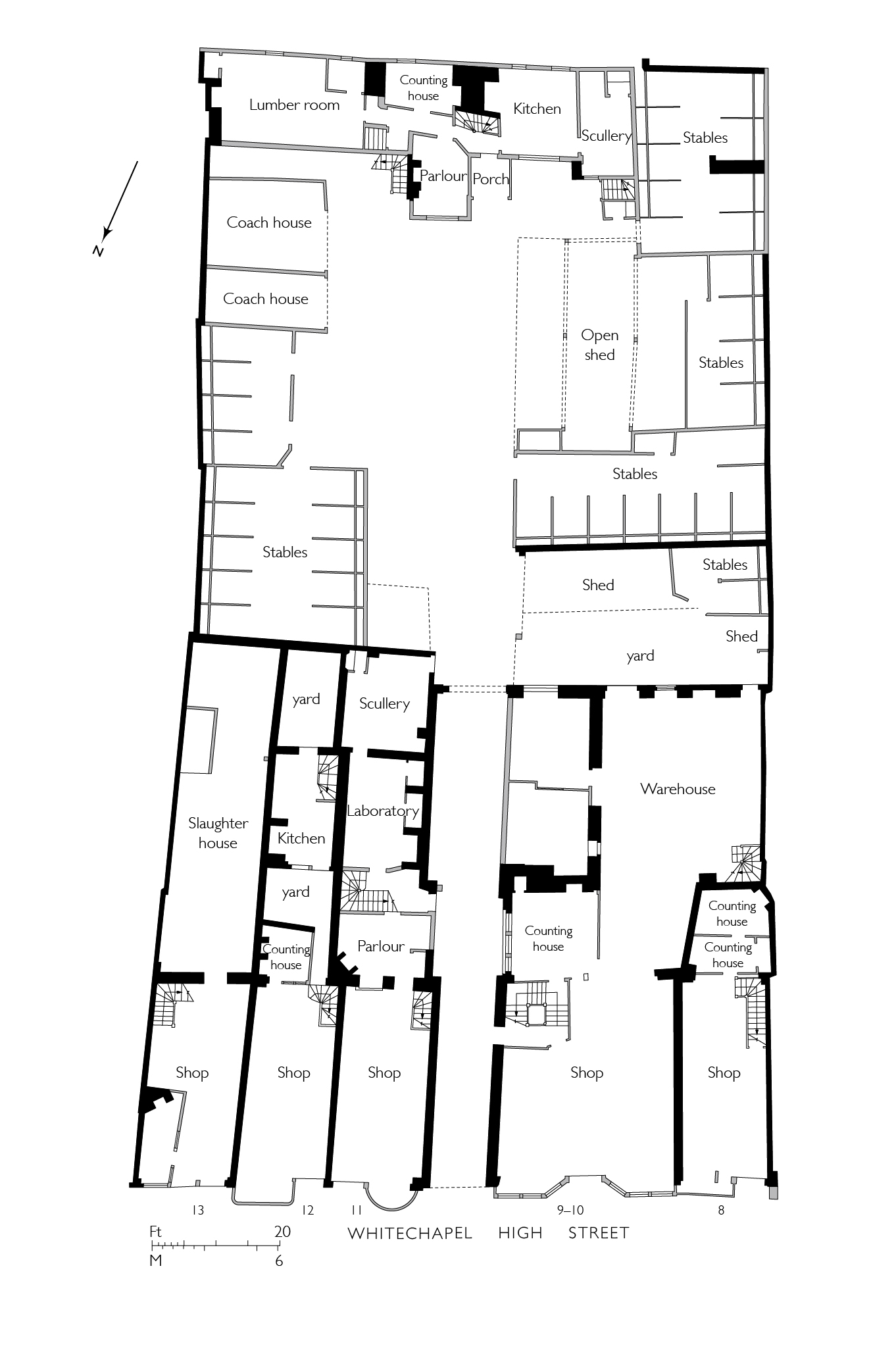
"id": 1715,
"title": "White Hart Yard behind 8–13 Whitechapel High Street, c.1825",
"author": {
"id": 82,
"username": "HelenJones"
},
"feature": {
"id": 8,
"type": "Feature",
"geometry": {
"type": "MultiPolygon",
"coordinates": [
[
[
[
-0.073603320060571,
51.51442327236536
],
[
-0.07261601532333,
51.51479023781785
],
[
-0.072264192178305,
51.514410425590924
],
[
-0.073236796882946,
51.514043833466424
],
[
-0.073307790491948,
51.51410595311657
],
[
-0.073389035166878,
51.51407809430392
],
[
-0.073613325753717,
51.514325591848184
],
[
-0.073536413082246,
51.514353078477846
],
[
-0.073603320060571,
51.51442327236536
]
]
]
]
},
"properties": {
"b_number": "10",
"b_name": "The White Chapel Building (former Sedgwick Centre)",
"street": "Whitechapel High Street",
"address": "10 Whitechapel High Street",
"feature_type": "WHITECHAPEL_BUILDING",
"count": 11,
"search_str": "The White Chapel Building (former Sedgwick Centre)"
},
"tags": []
},
"file": "https://surveyoflondon.org/media/uploads/features/8/White%20Hart%20Yard%20Plan%203.jpg",
"description": "drawing by Helen Jones based on a plan in the Mercers' Company Archives, Dean Colet Estate plans, plate 33 (with thanks to Andrew Byrne and Kate Higgins)",
"copyright": true,
"created": "2020-05-14"
},
{
"id": 1414,
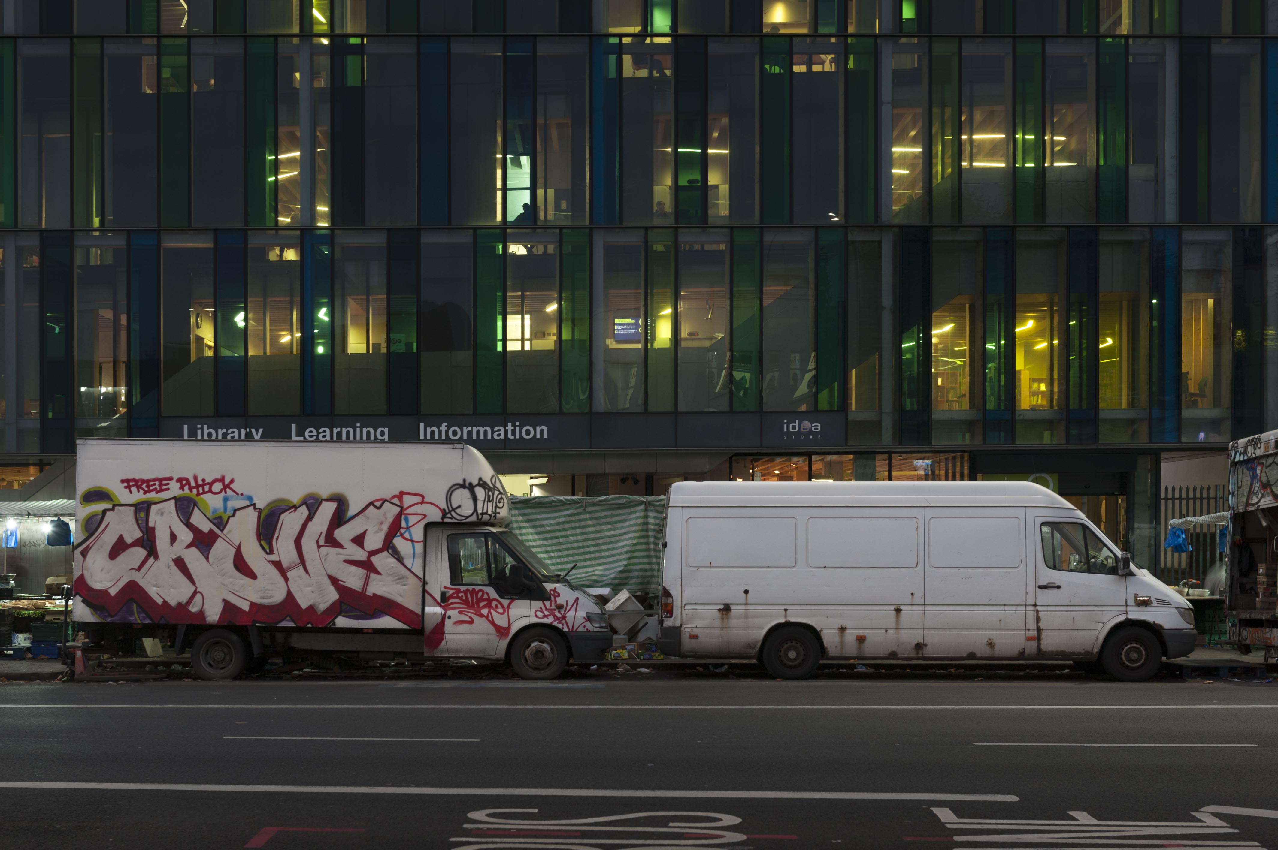
"title": "Market vans in late 2018",
"author": {
"id": 27,
"username": "DerekKendall"
},
"feature": {
"id": 1698,
"type": "Feature",
"geometry": {
"type": "MultiPolygon",
"coordinates": [
[
[
[
-0.062755898137067,
51.51857235799611
],
[
-0.058216859270041,
51.51960039921044
],
[
-0.058148482851386,
51.51948612756745
],
[
-0.061091729886378,
51.51883423152082
],
[
-0.061616259170046,
51.51871888429734
],
[
-0.06270768344222,
51.51847582817058
],
[
-0.062755898137067,
51.51857235799611
]
]
]
]
},
"properties": {
"b_number": "",
"b_name": "",
"street": "Whitechapel Road",
"address": "Whitechapel Market, Whitechapel Road",
"feature_type": "PLACE",
"count": 48,
"search_str": "Whitechapel Market, Whitechapel Road"
},
"tags": []
},
"file": "https://surveyoflondon.org/media/uploads/features/1698/SoL%20Whitechapel%20102269.jpg",
"description": "",
"copyright": true,
"created": "2018-11-13"
},
{
"id": 1840,
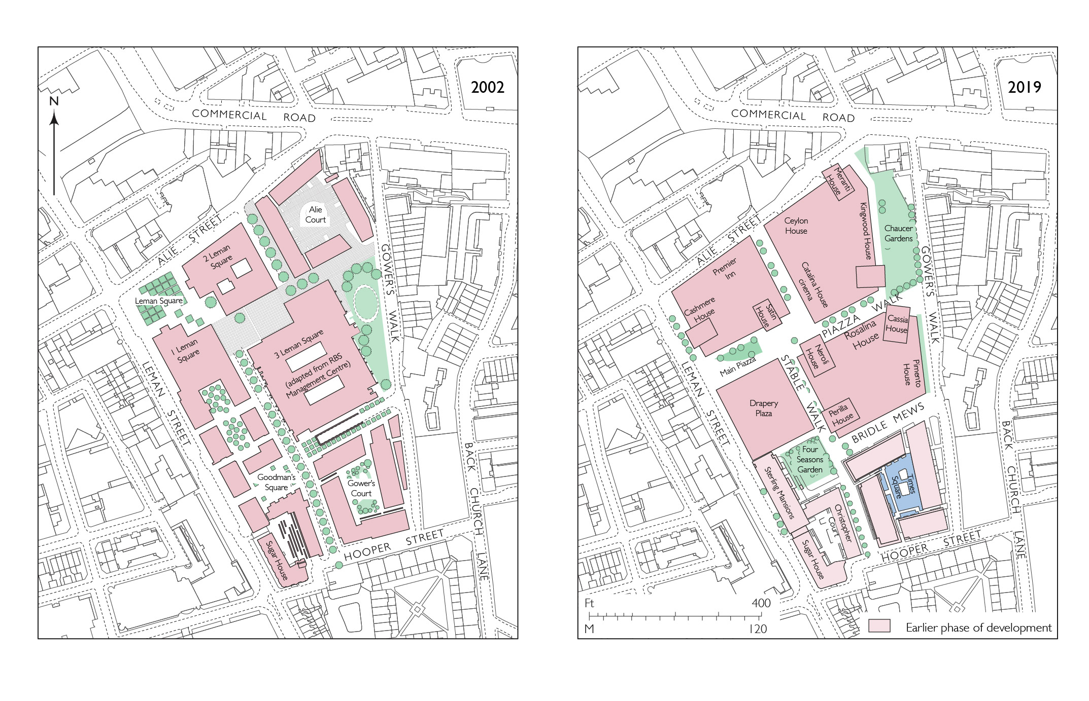
"title": "Goodman's Fields, block plans, as proposed in 2002 and as completed in 2019 (base map 2015, drawing by Helen Jones)",
"author": {
"id": 2,
"username": "surveyoflondon"
},
"feature": {
"id": 1457,
"type": "Feature",
"geometry": {
"type": "MultiPolygon",
"coordinates": [
[
[
[
-0.070203073964938,
51.51342219546891
],
[
-0.069147493837327,
51.51381196963451
],
[
-0.068970962595089,
51.51361513736259
],
[
-0.070053986774662,
51.51323697832119
],
[
-0.070203073964938,
51.51342219546891
]
]
]
]
},
"properties": {
"b_number": "",
"b_name": "Piazza Walk, Goodman's Fields",
"street": "Leman Street",
"address": "Piazza Walk, Goodman's Fields",
"feature_type": "OPEN_SPACE",
"count": 8,
"search_str": "Piazza Walk, Goodman's Fields"
},
"tags": []
},
"file": "https://surveyoflondon.org/media/uploads/features/1457/38.23%20goodmans%20Fields%20OS%20map.jpg",
"description": "",
"copyright": true,
"created": "2021-05-04"
},
{
"id": 878,
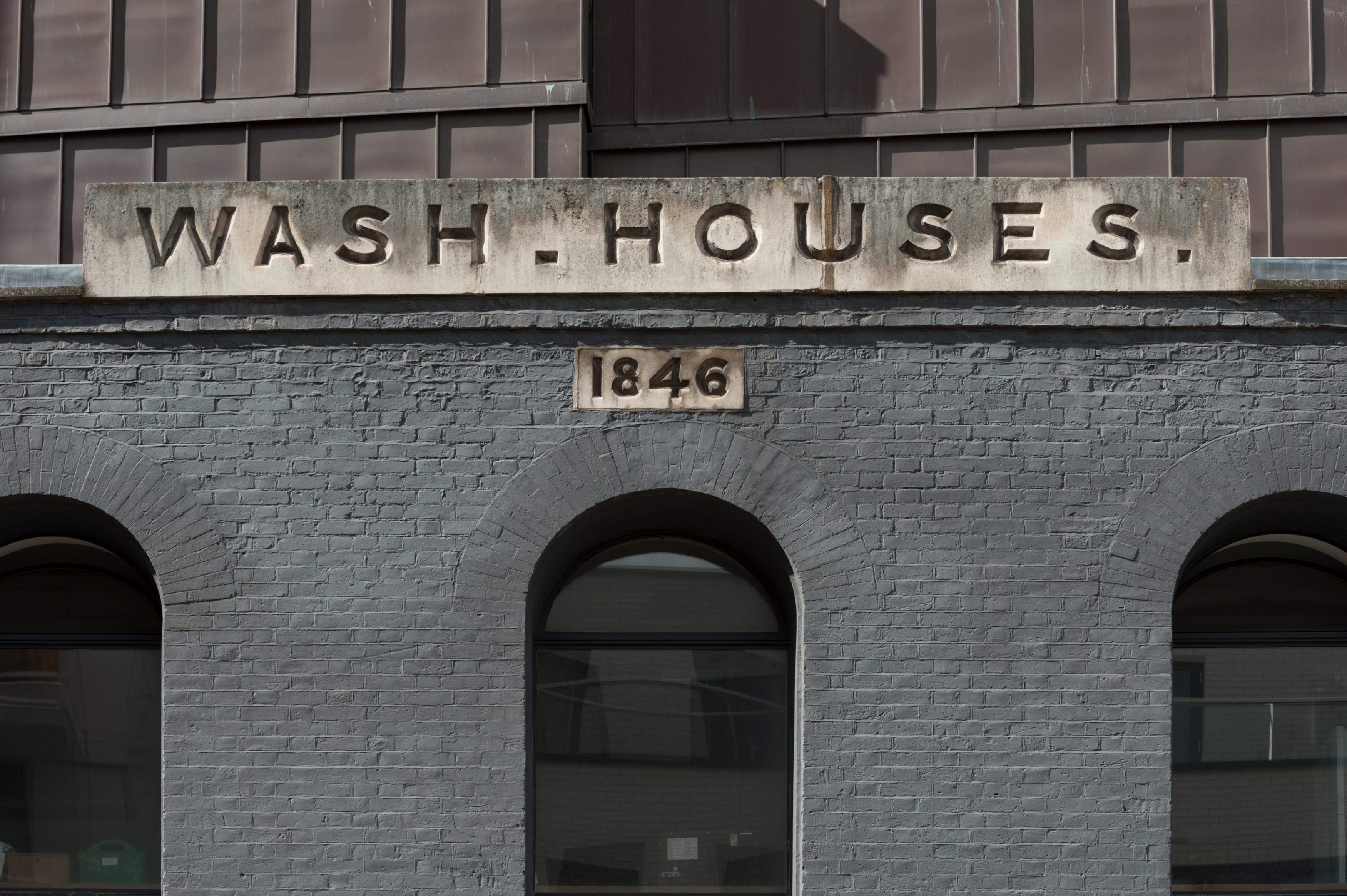
"title": "Detail of the Wash Houses, August 2017",
"author": {
"id": 27,
"username": "DerekKendall"
},
"feature": {
"id": 1447,
"type": "Feature",
"geometry": {
"type": "MultiPolygon",
"coordinates": [
[
[
[
-0.073620345272929,
51.51568885255038
],
[
-0.073978291920849,
51.515581075868006
],
[
-0.074105154053684,
51.51572542989613
],
[
-0.073829058934223,
51.51581988475423
],
[
-0.073816416255057,
51.51580549883457
],
[
-0.073765536685163,
51.515822645959325
],
[
-0.073818338832879,
51.51587274604106
],
[
-0.073896057393162,
51.515850404112115
],
[
-0.073900642179228,
51.51585546922409
],
[
-0.073811510459007,
51.51588294615875
],
[
-0.073751379811388,
51.51582774828753
],
[
-0.073609777363084,
51.515693181519985
],
[
-0.073620345272929,
51.51568885255038
]
]
]
]
},
"properties": {
"b_number": "25",
"b_name": "The Wash Houses, London Metropolitan University, former Whitechapel Baths",
"street": "Old Castle Street",
"address": "The Wash Houses, London Metropolitan Univeristy, 25 Old Castle Street, London E1 7NT",
"feature_type": "WHITECHAPEL_BUILDING",
"count": 19,
"search_str": "The Wash Houses, London Metropolitan University, former Whitechapel Baths"
},
"tags": [
"cholera",
"library",
"swimming",
"washing",
"women"
]
},
"file": "https://surveyoflondon.org/media/uploads/features/1447/SoL%20Whitechapel%20101289.jpg",
"description": "",
"copyright": true,
"created": "2017-09-26"
},
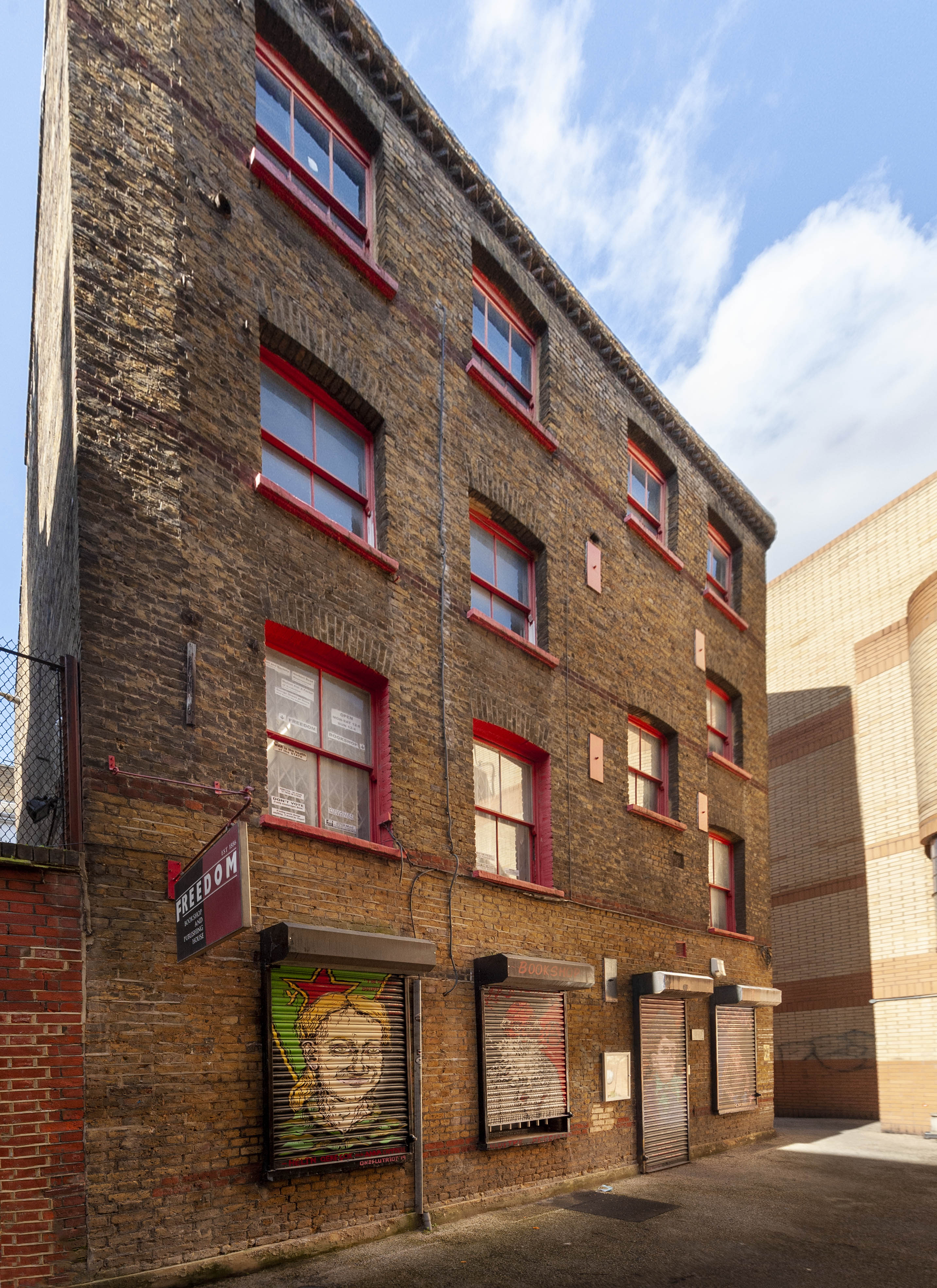
{
"id": 1819,
"title": "Freedom Bookshop, 84B Whitechapel High Street, in early 2021 during lockdown",
"author": {
"id": 27,
"username": "DerekKendall"
},
"feature": {
"id": 397,
"type": "Feature",
"geometry": {
"type": "MultiPolygon",
"coordinates": [
[
[
[
-0.070631734980517,
51.516055421900404
],
[
-0.070694810837976,
51.5160316148736
],
[
-0.070694812656241,
51.51603160856848
],
[
-0.070694822071344,
51.51603161810757
],
[
-0.070705382817133,
51.51602803925736
],
[
-0.070776774733246,
51.516123324187696
],
[
-0.070694983149094,
51.516128965932744
],
[
-0.070631734980517,
51.516055421900404
]
]
]
]
},
"properties": {
"b_number": "84B",
"b_name": "84B Whitechapel High Street",
"street": "Angel Alley, Whitechapel High Street",
"address": " 84B Whitechapel High Street",
"feature_type": "WHITECHAPEL_BUILDING",
"count": 10,
"search_str": "84B Whitechapel High Street"
},
"tags": []
},
"file": "https://surveyoflondon.org/media/uploads/features/397/SoL%20Whitechapel%20102901.jpg",
"description": "",
"copyright": true,
"created": "2021-03-30"
},
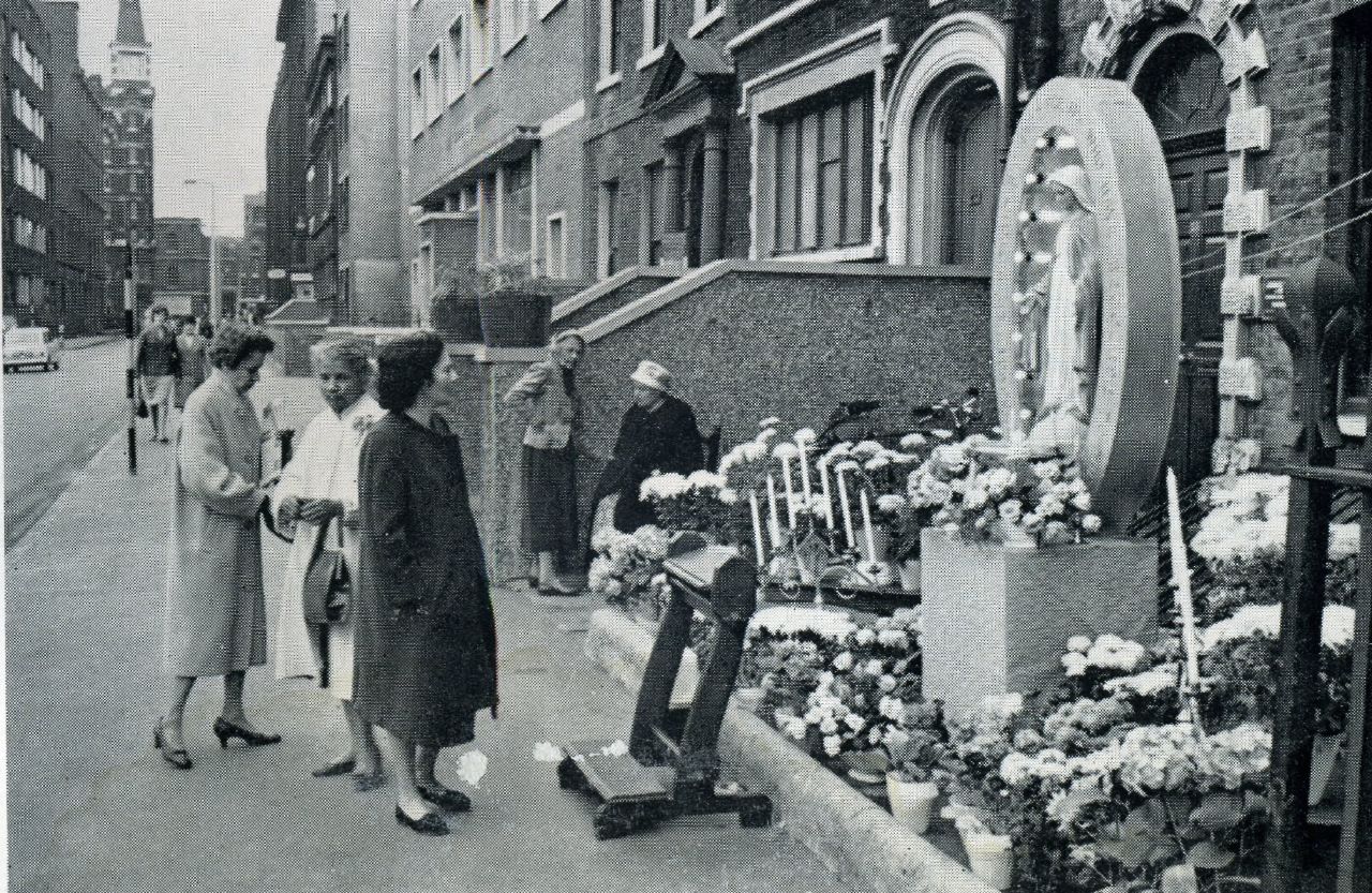
{
"id": 1151,
"title": "Catholic Procession Altar, 1960s",
"author": {
"id": 153,
"username": "danny"
},
"feature": {
"id": 1293,
"type": "Feature",
"geometry": {
"type": "MultiPolygon",
"coordinates": [
[
[
[
-0.071513981451963,
51.511415502887715
],
[
-0.071477167616823,
51.511328407652236
],
[
-0.071532965125774,
51.51132107663319
],
[
-0.071527913476098,
51.51130754303777
],
[
-0.071561851787731,
51.51130283790823
],
[
-0.07160179754467,
51.51139998766625
],
[
-0.071513981451963,
51.511415502887715
]
]
]
]
},
"properties": {
"b_number": "23",
"b_name": "",
"street": "Prescot Street",
"address": "23 Prescot Street",
"feature_type": "WHITECHAPEL_BUILDING",
"count": 3,
"search_str": "23 Prescot Street"
},
"tags": []
},
"file": "https://surveyoflondon.org/media/uploads/features/1293/Catholic%20Procession%20Altar%201960s%20Prescot%20Sreet.jpg",
"description": "An image looking east along Prescot Street with an altar set up for the annual procession through the streets of the parish of English Martyrs' Church situated in Prescot Street. These processions continued until the 1980s before a decline in numbers of parishioners made them no longer feasible. This altar was set up outside the original presbytery (priest's house) of the Church. In the background, the tower on the Cooperative Wholesale Building (CWS) at 99 Leman Street can be seen.",
"copyright": false,
"created": "2018-03-04"
},
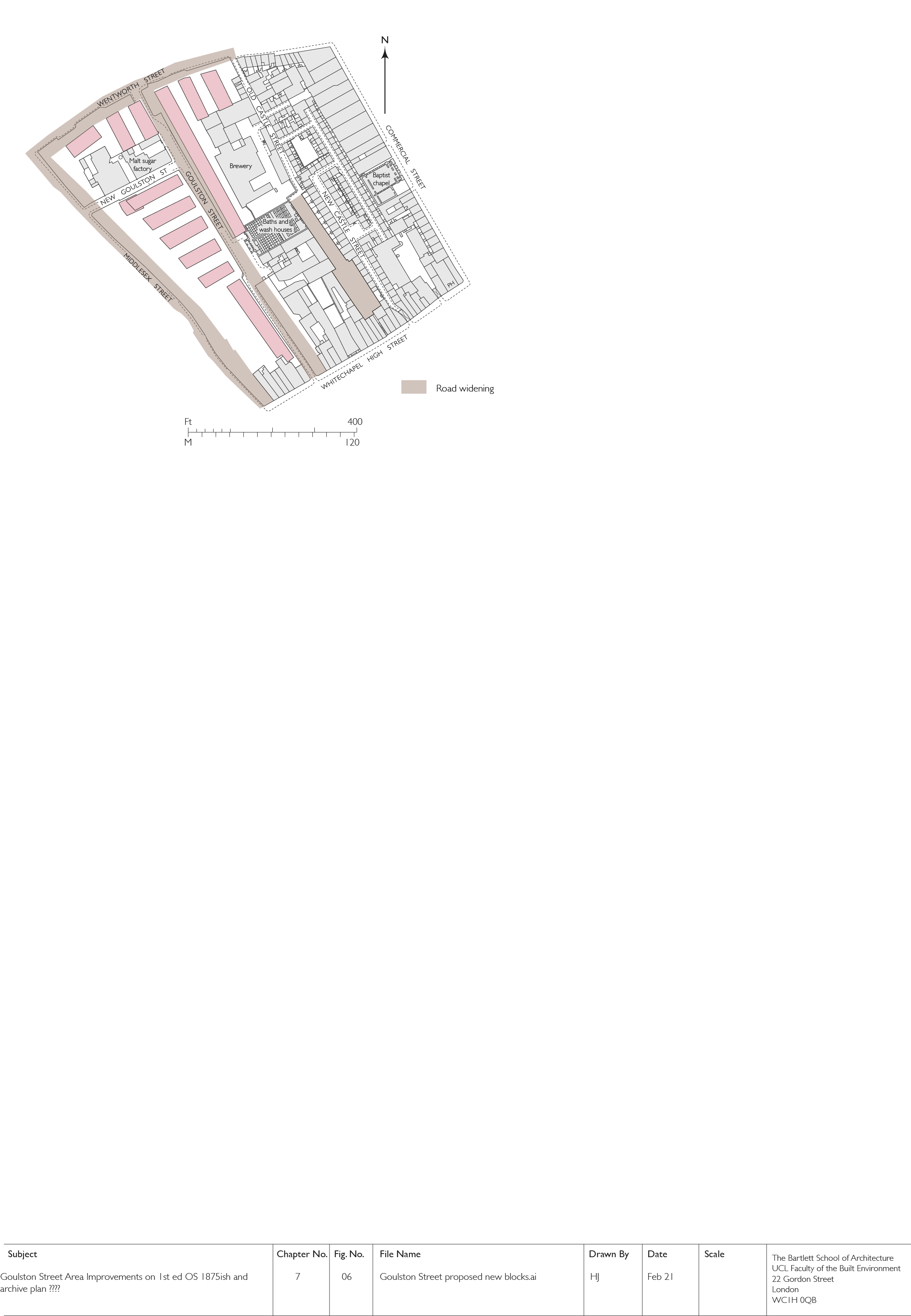
{
"id": 1828,
"title": "Goulston Street Improvement, early proposed layout (drawing by Helen Jones)",
"author": {
"id": 2,
"username": "surveyoflondon"
},
"feature": {
"id": 359,
"type": "Feature",
"geometry": {
"type": "MultiPolygon",
"coordinates": [
[
[
[
-0.074396169724534,
51.51674677293217
],
[
-0.074344918245201,
51.51668771806432
],
[
-0.074415391815644,
51.51667127366158
],
[
-0.074407427802984,
51.51665783673676
],
[
-0.074464842346045,
51.51664692918775
],
[
-0.074451564815962,
51.516627570285934
],
[
-0.074484845350984,
51.516618730970194
],
[
-0.074449462429928,
51.5165697349019
],
[
-0.074495929828979,
51.51655683248676
],
[
-0.074450946678382,
51.516491607819624
],
[
-0.074715152431625,
51.51642099545545
],
[
-0.074553943007666,
51.516244787362865
],
[
-0.074798574993366,
51.51616849501834
],
[
-0.075086564069636,
51.51652796045754
],
[
-0.075099913362563,
51.51652379724113
],
[
-0.075167749140884,
51.51660846832082
],
[
-0.074396169724534,
51.51674677293217
]
]
]
]
},
"properties": {
"b_number": "",
"b_name": "Arcadia Court, formerly 90 to 222 Wentworth Dwellings",
"street": "Goulston Street",
"address": "Arcadia Court, formerly 90 to 222 Wentworth Dwellings",
"feature_type": "WHITECHAPEL_BUILDING",
"count": 8,
"search_str": "Arcadia Court, formerly 90 to 222 Wentworth Dwellings"
},
"tags": []
},
"file": "https://surveyoflondon.org/media/uploads/features/359/7.6%20Goulston%20Street%20proposed%20new%20blocks%201%20final.jpg",
"description": "",
"copyright": true,
"created": "2021-05-04"
},
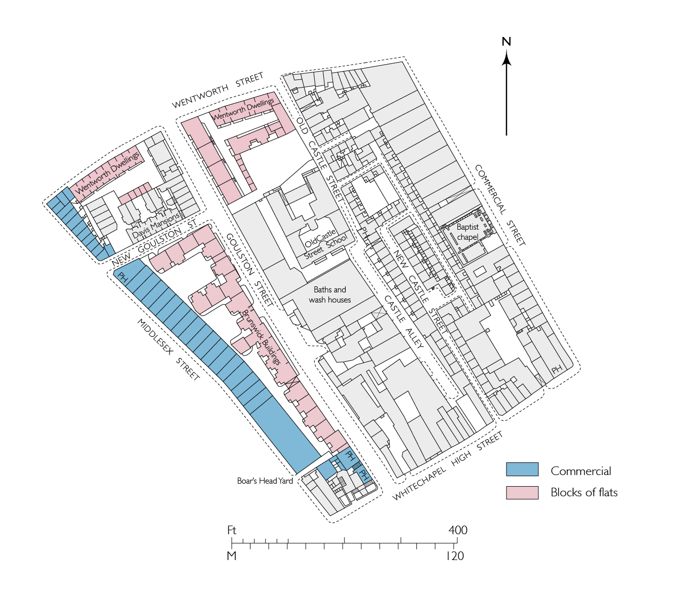
{
"id": 1829,
"title": "Goulston Street Improvement, redevelopment as completed by 1894 (drawing by Helen Jones)",
"author": {
"id": 2,
"username": "surveyoflondon"
},
"feature": {
"id": 359,
"type": "Feature",
"geometry": {
"type": "MultiPolygon",
"coordinates": [
[
[
[
-0.074396169724534,
51.51674677293217
],
[
-0.074344918245201,
51.51668771806432
],
[
-0.074415391815644,
51.51667127366158
],
[
-0.074407427802984,
51.51665783673676
],
[
-0.074464842346045,
51.51664692918775
],
[
-0.074451564815962,
51.516627570285934
],
[
-0.074484845350984,
51.516618730970194
],
[
-0.074449462429928,
51.5165697349019
],
[
-0.074495929828979,
51.51655683248676
],
[
-0.074450946678382,
51.516491607819624
],
[
-0.074715152431625,
51.51642099545545
],
[
-0.074553943007666,
51.516244787362865
],
[
-0.074798574993366,
51.51616849501834
],
[
-0.075086564069636,
51.51652796045754
],
[
-0.075099913362563,
51.51652379724113
],
[
-0.075167749140884,
51.51660846832082
],
[
-0.074396169724534,
51.51674677293217
]
]
]
]
},
"properties": {
"b_number": "",
"b_name": "Arcadia Court, formerly 90 to 222 Wentworth Dwellings",
"street": "Goulston Street",
"address": "Arcadia Court, formerly 90 to 222 Wentworth Dwellings",
"feature_type": "WHITECHAPEL_BUILDING",
"count": 8,
"search_str": "Arcadia Court, formerly 90 to 222 Wentworth Dwellings"
},
"tags": []
},
"file": "https://surveyoflondon.org/media/uploads/features/359/7.6b%20Goulston%20Street%202nd%20ed%20os%20final.jpg",
"description": "",
"copyright": true,
"created": "2021-05-04"
},
{
"id": 1811,
"title": "33 Commercial Road in 2021",
"author": {
"id": 27,
"username": "DerekKendall"
},
"feature": {
"id": 103,
"type": "Feature",
"geometry": {
"type": "MultiPolygon",
"coordinates": [
[
[
[
-0.068374712930605,
51.5151408298259
],
[
-0.06804295614913,
51.51523312333845
],
[
-0.067818209826392,
51.51529176188959
],
[
-0.067732324854293,
51.51515294140592
],
[
-0.068296249445127,
51.51502991558809
],
[
-0.068374712930605,
51.5151408298259
]
]
]
]
},
"properties": {
"b_number": "33",
"b_name": "",
"street": "Commercial Road",
"address": "Former St George's Brewery, 33 Commercial Road",
"feature_type": "WHITECHAPEL_BUILDING",
"count": 8,
"search_str": "Former St George's Brewery, 33 Commercial Road"
},
"tags": [
"brewery"
]
},
"file": "https://surveyoflondon.org/media/uploads/features/103/SoL%20Whitechapel%20102869.jpg",
"description": "",
"copyright": true,
"created": "2021-03-30"
},
{
"id": 1140,
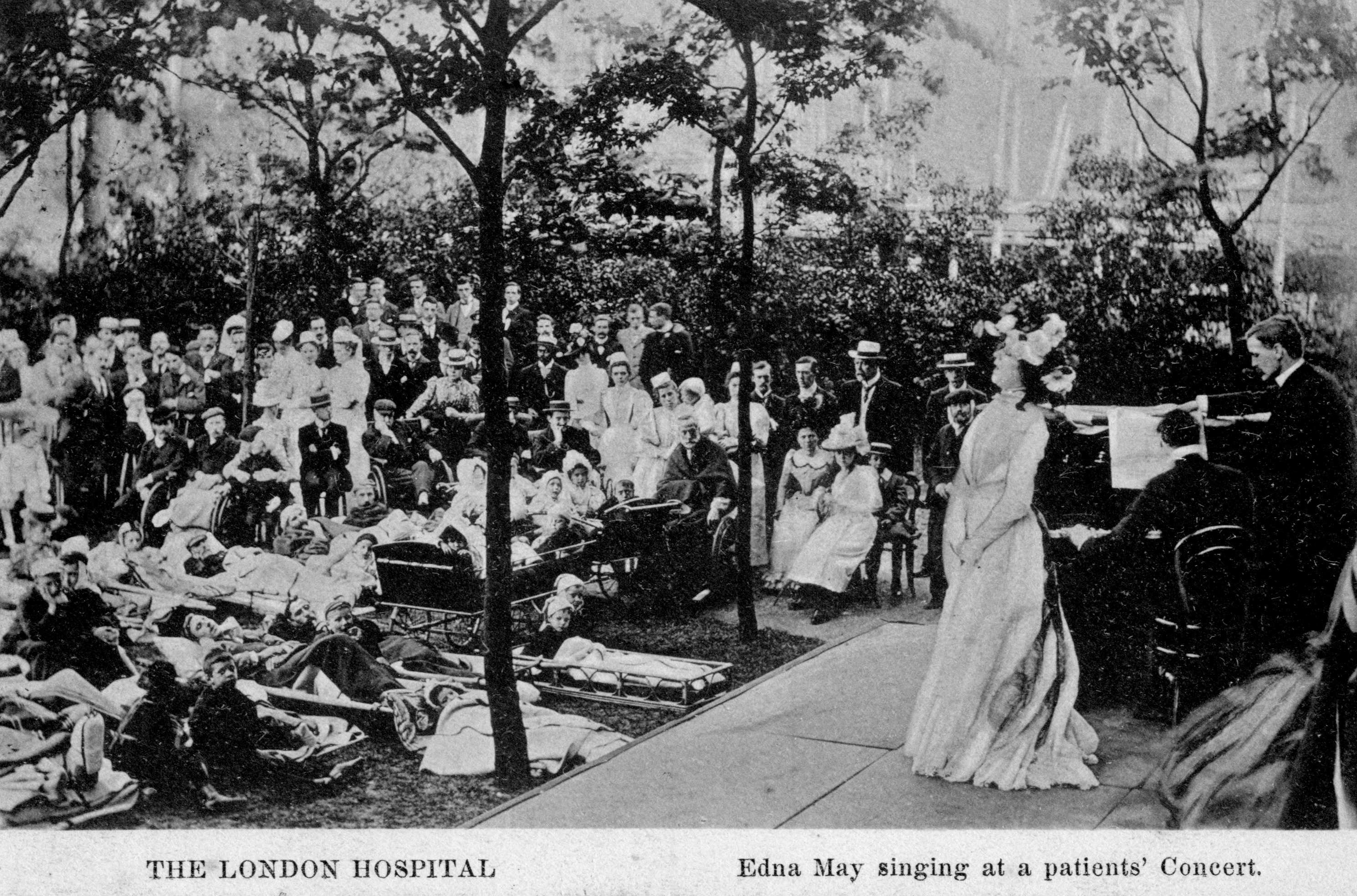
"title": "Edna May singing at a patients' concert in the hospital garden in 1901",
"author": {
"id": 2,
"username": "surveyoflondon"
},
"feature": {
"id": 1230,
"type": "Feature",
"geometry": {
"type": "MultiPolygon",
"coordinates": [
[
[
[
-0.06071898744648,
51.51847914149303
],
[
-0.060743358937849,
51.518529899918775
],
[
-0.060362148562617,
51.518618013153
],
[
-0.060404024127419,
51.51868851949335
],
[
-0.060356952993906,
51.51869974522794
],
[
-0.060399234817198,
51.51877056309998
],
[
-0.060042469531136,
51.5188530372297
],
[
-0.060006551123239,
51.51879256032364
],
[
-0.05997171006068,
51.51880061452483
],
[
-0.059923949522789,
51.51872019830377
],
[
-0.059602716389847,
51.51879445706454
],
[
-0.059631951693606,
51.51884368227145
],
[
-0.059135089420495,
51.51895853862307
],
[
-0.059031394281591,
51.51878393727422
],
[
-0.059075483581288,
51.51877374555587
],
[
-0.05923306113512,
51.518737319626666
],
[
-0.059261815633844,
51.518785736083466
],
[
-0.059453095208379,
51.51874286661955
],
[
-0.059437777096903,
51.51871791341666
],
[
-0.059509844762857,
51.518701022201654
],
[
-0.059472510825189,
51.51863713193043
],
[
-0.059893693119402,
51.51853565124978
],
[
-0.059897251108141,
51.51854177905041
],
[
-0.060406197614306,
51.5184267554985
],
[
-0.060388475186227,
51.51839623334771
],
[
-0.060226549751936,
51.51811735804654
],
[
-0.060490662909997,
51.51805857683586
],
[
-0.060500593175314,
51.518078725457706
],
[
-0.06071898744648,
51.51847914149303
]
]
]
]
},
"properties": {
"b_number": "",
"b_name": "Former Royal London Hospital",
"street": "",
"address": "Former Royal London Hospital ",
"feature_type": "WHITECHAPEL_BUILDING",
"count": 53,
"search_str": "Former Royal London Hospital"
},
"tags": []
},
"file": "https://surveyoflondon.org/media/uploads/features/1230/Edna%20May%20singing011.jpg",
"description": "",
"copyright": false,
"created": "2018-02-14"
},
{
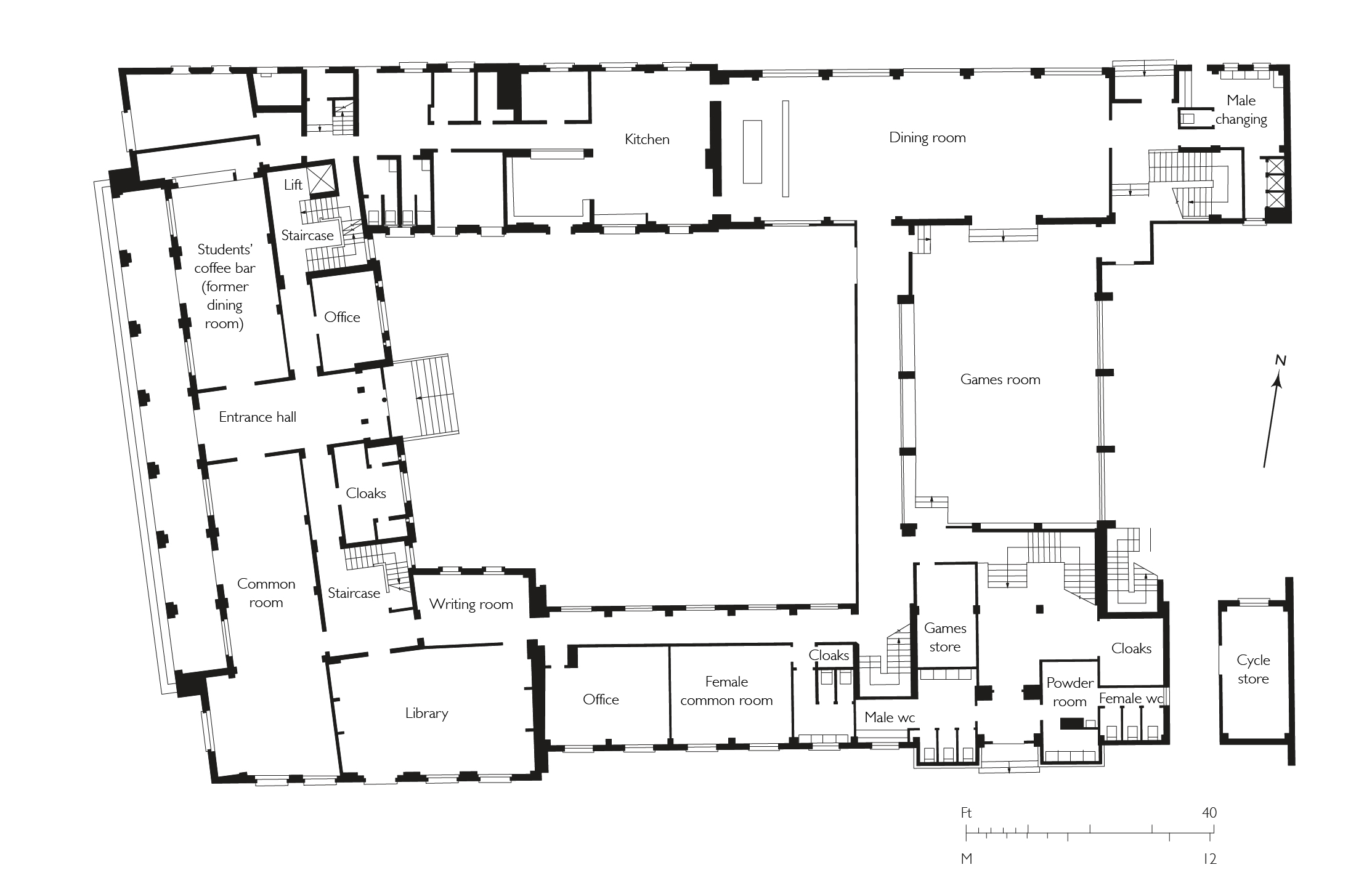
"id": 1845,
"title": "Floyer House, ground plan in 1960 (drawing by Helen Jones)",
"author": {
"id": 2,
"username": "surveyoflondon"
},
"feature": {
"id": 1056,
"type": "Feature",
"geometry": {
"type": "MultiPolygon",
"coordinates": [
[
[
[
-0.059263722432195,
51.5170504174262
],
[
-0.05844902615524,
51.517123873126295
],
[
-0.058429001918928,
51.51704425139911
],
[
-0.058539791655921,
51.51703426162738
],
[
-0.058495779438244,
51.516894701346835
],
[
-0.058661010499377,
51.5168776379586
],
[
-0.05870302857902,
51.51702305338288
],
[
-0.059049997696211,
51.51699054250981
],
[
-0.058993641915522,
51.516847722030604
],
[
-0.058915395385419,
51.51685268666606
],
[
-0.058912319350653,
51.51684637599849
],
[
-0.058396219583371,
51.5168976477387
],
[
-0.058372064688884,
51.51681030679901
],
[
-0.058895931974683,
51.516759859268696
],
[
-0.05889396995395,
51.51675356703994
],
[
-0.059125366976984,
51.51673861770239
],
[
-0.059263722432195,
51.5170504174262
]
]
]
]
},
"properties": {
"b_number": "60",
"b_name": "Floyer House",
"street": "Newark Street",
"address": "Floyer House",
"feature_type": "WHITECHAPEL_BUILDING",
"count": 3,
"search_str": "Floyer House"
},
"tags": [
"Edward Maufe"
]
},
"file": "https://surveyoflondon.org/media/uploads/features/1056/27.25%20Floyer%20House%203.jpg",
"description": "",
"copyright": true,
"created": "2021-07-31"
},
{
"id": 1718,
"title": "60 Commercial Road from the north-east in 2017",
"author": {
"id": 27,
"username": "DerekKendall"
},
"feature": {
"id": 997,
"type": "Feature",
"geometry": {
"type": "MultiPolygon",
"coordinates": [
[
[
[
-0.067164508046975,
51.51459719968502
],
[
-0.067148423655411,
51.514715895823834
],
[
-0.066610988305759,
51.514684919110756
],
[
-0.066621196345999,
51.51456232678496
],
[
-0.066691581019596,
51.51456664936773
],
[
-0.066721075750017,
51.51437030130085
],
[
-0.066966701240129,
51.5143849758262
],
[
-0.066934388824375,
51.514583398373624
],
[
-0.067164508046975,
51.51459719968502
]
]
]
]
},
"properties": {
"b_number": "60",
"b_name": "Pure Aldgate, 60 Commercial Road",
"street": "Commercial Road",
"address": "iQ Aldgate, 60 Commercial Road",
"feature_type": "WHITECHAPEL_BUILDING",
"count": 3,
"search_str": "Pure Aldgate, 60 Commercial Road"
},
"tags": []
},
"file": "https://surveyoflondon.org/media/uploads/features/997/SoL%20Whitechapel%20101268.jpg",
"description": "",
"copyright": true,
"created": "2020-06-01"
},
{
"id": 1719,
"title": "60 Commercial Road from the north-west in 2017",
"author": {
"id": 27,
"username": "DerekKendall"
},
"feature": {
"id": 997,
"type": "Feature",
"geometry": {
"type": "MultiPolygon",
"coordinates": [
[
[
[
-0.067164508046975,
51.51459719968502
],
[
-0.067148423655411,
51.514715895823834
],
[
-0.066610988305759,
51.514684919110756
],
[
-0.066621196345999,
51.51456232678496
],
[
-0.066691581019596,
51.51456664936773
],
[
-0.066721075750017,
51.51437030130085
],
[
-0.066966701240129,
51.5143849758262
],
[
-0.066934388824375,
51.514583398373624
],
[
-0.067164508046975,
51.51459719968502
]
]
]
]
},
"properties": {
"b_number": "60",
"b_name": "Pure Aldgate, 60 Commercial Road",
"street": "Commercial Road",
"address": "iQ Aldgate, 60 Commercial Road",
"feature_type": "WHITECHAPEL_BUILDING",
"count": 3,
"search_str": "Pure Aldgate, 60 Commercial Road"
},
"tags": []
},
"file": "https://surveyoflondon.org/media/uploads/features/997/SoL%20Whitechapel%20101272.jpg",
"description": "",
"copyright": true,
"created": "2020-06-01"
},
{
"id": 491,
"title": "Tilbury warehouse",
"author": {
"id": 72,
"username": "eric"
},
"feature": {
"id": 1039,
"type": "Feature",
"geometry": {
"type": "MultiPolygon",
"coordinates": [
[
[
[
-0.067760420507904,
51.51391542058649
],
[
-0.06765783574787,
51.51391682912958
],
[
-0.067654551224466,
51.51385792281936
],
[
-0.067750438366323,
51.513857416217355
],
[
-0.067760420507904,
51.51391542058649
]
]
]
]
},
"properties": {
"b_number": "49",
"b_name": "49 Gower's Walk",
"street": "Gower's Walk",
"address": "49 Gower's Walk",
"feature_type": "WHITECHAPEL_BUILDING",
"count": 8,
"search_str": "49 Gower's Walk"
},
"tags": []
},
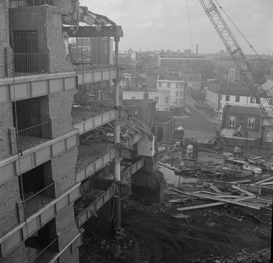
"file": "https://surveyoflondon.org/media/uploads/features/1039/Tilbury%20warehouse.jpg",
"description": "In the 1950/1960s my bedroom faced the east wall of the giant Tilbury Warehouse. I could not see in - its windows were never clean. But this photo of its demolition looks out on to Commercial Road at its north. You can see remnants of the north-end light-well that let in light to all floors. If you look closely you can see a round brick gatepost with a white top at the main entrance. I passed them daily walking to catch my school bus.",
"copyright": false,
"created": "2017-01-26"
},
{
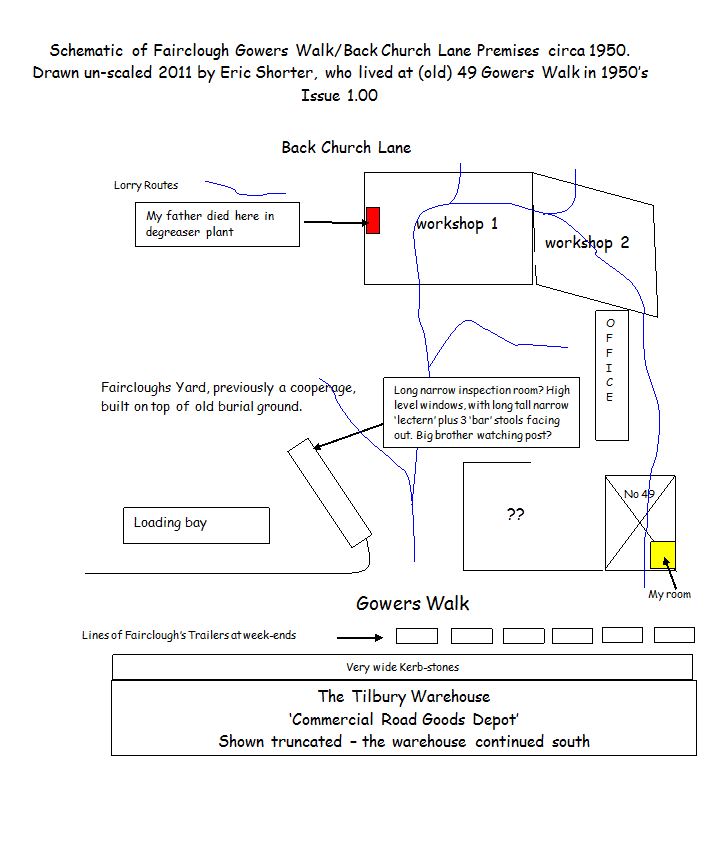
"id": 482,
"title": "Plan of Fairclough's Yard, c. 1950",
"author": {
"id": 72,
"username": "eric"
},
"feature": {
"id": 1035,
"type": "Feature",
"geometry": {
"type": "MultiPolygon",
"coordinates": [
[
[
[
-0.067795056111784,
51.51411668057842
],
[
-0.067669334925435,
51.51412306030316
],
[
-0.067667192182729,
51.514084631545984
],
[
-0.067788481441036,
51.5140784767178
],
[
-0.067795056111784,
51.51411668057842
]
]
]
]
},
"properties": {
"b_number": "53",
"b_name": "53 Gower's Walk",
"street": "Gower's Walk",
"address": "53 Gower's Walk",
"feature_type": "WHITECHAPEL_BUILDING",
"count": 4,
"search_str": "53 Gower's Walk"
},
"tags": []
},
"file": "https://surveyoflondon.org/media/uploads/features/1035/Eric%20Shorter%20plan%20of%20Faircloughs%20Yard%20c%201950.JPG",
"description": "This schematic plan by Eric Shorter (b. 1936) shows the layout of the yard of T.M. Fairclough, meat hauliers, as it was around 1950 when he lived in a flat at No 49, near the yard's main entrance.",
"copyright": false,
"created": "2017-01-18"
},
{
"id": 386,
"title": "United Standard House and Cromlech House from the northeast in 2016",
"author": {
"id": 27,
"username": "DerekKendall"
},
"feature": {
"id": 350,
"type": "Feature",
"geometry": {
"type": "MultiPolygon",
"coordinates": [
[
[
[
-0.074647451142337,
51.51530527967592
],
[
-0.074357471765638,
51.515414167283886
],
[
-0.073990659509213,
51.51505709668585
],
[
-0.074395588069206,
51.514895160577964
],
[
-0.074663489419344,
51.51509835683479
],
[
-0.074491595155131,
51.515179363370244
],
[
-0.074647451142337,
51.51530527967592
]
]
]
]
},
"properties": {
"b_number": "2-14",
"b_name": "United Standard House",
"street": "Middlesex Street",
"address": "2 to 14 Middlesex Street",
"feature_type": "WHITECHAPEL_BUILDING",
"count": 16,
"search_str": "United Standard House"
},
"tags": []
},
"file": "https://surveyoflondon.org/media/uploads/features/350/SoL%20Whitechapel100295.jpg",
"description": "",
"copyright": true,
"created": "2016-09-13"
},
{
"id": 1730,
"title": "Royal College of Pathologists from the south in 2019",
"author": {
"id": 27,
"username": "DerekKendall"
},
"feature": {
"id": 38,
"type": "Feature",
"geometry": {
"type": "MultiPolygon",
"coordinates": [
[
[
[
-0.072769869537147,
51.51314834719593
],
[
-0.072478836917296,
51.51321048439805
],
[
-0.072355493685702,
51.51292927094216
],
[
-0.072672904111031,
51.51288088167866
],
[
-0.072771908194299,
51.51314802689543
],
[
-0.072769869537147,
51.51314834719593
]
]
]
]
},
"properties": {
"b_number": "6",
"b_name": "Royal College of Pathologists, 6 Alie Street",
"street": "Alie Street",
"address": "Royal College of Pathologists, 6 Alie Street",
"feature_type": "WHITECHAPEL_BUILDING",
"count": 5,
"search_str": "Royal College of Pathologists, 6 Alie Street"
},
"tags": []
},
"file": "https://surveyoflondon.org/media/uploads/features/38/SoL%20Whitechapel%20102714.jpg",
"description": "",
"copyright": true,
"created": "2020-06-05"
},
{
"id": 1731,
"title": "Royal College of Pathologists from the north in 2019",
"author": {
"id": 27,
"username": "DerekKendall"
},
"feature": {
"id": 38,
"type": "Feature",
"geometry": {
"type": "MultiPolygon",
"coordinates": [
[
[
[
-0.072769869537147,
51.51314834719593
],
[
-0.072478836917296,
51.51321048439805
],
[
-0.072355493685702,
51.51292927094216
],
[
-0.072672904111031,
51.51288088167866
],
[
-0.072771908194299,
51.51314802689543
],
[
-0.072769869537147,
51.51314834719593
]
]
]
]
},
"properties": {
"b_number": "6",
"b_name": "Royal College of Pathologists, 6 Alie Street",
"street": "Alie Street",
"address": "Royal College of Pathologists, 6 Alie Street",
"feature_type": "WHITECHAPEL_BUILDING",
"count": 5,
"search_str": "Royal College of Pathologists, 6 Alie Street"
},
"tags": []
},
"file": "https://surveyoflondon.org/media/uploads/features/38/SoL%20Whitechapel%20102717.jpg",
"description": "",
"copyright": true,
"created": "2020-06-05"
},
{
"id": 1525,
"title": "Natwest Bank cheque-clearing centre",
"author": {
"id": 153,
"username": "danny"
},
"feature": {
"id": 1047,
"type": "Feature",
"geometry": {
"type": "MultiPolygon",
"coordinates": [
[
[
[
-0.070507285693422,
51.51383090440113
],
[
-0.069707737237537,
51.514184751452724
],
[
-0.069322145577777,
51.513819239326324
],
[
-0.069477910961367,
51.5137516492373
],
[
-0.069449902184866,
51.51371686688633
],
[
-0.069614131036717,
51.513655768609844
],
[
-0.069648590074739,
51.51369101943822
],
[
-0.070222944111541,
51.513488026703634
],
[
-0.070278058062727,
51.513554501477984
],
[
-0.070306902534867,
51.51354356766092
],
[
-0.070379446811545,
51.513631553258705
],
[
-0.070350540554201,
51.51364190115836
],
[
-0.070507285693422,
51.51383090440113
]
]
]
]
},
"properties": {
"b_number": "66",
"b_name": "Premier Inn, 66 Alie Street",
"street": "Alie Street",
"address": "Premier Inn, 66 Alie Street",
"feature_type": "WHITECHAPEL_BUILDING",
"count": 14,
"search_str": "Premier Inn, 66 Alie Street"
},
"tags": []
},
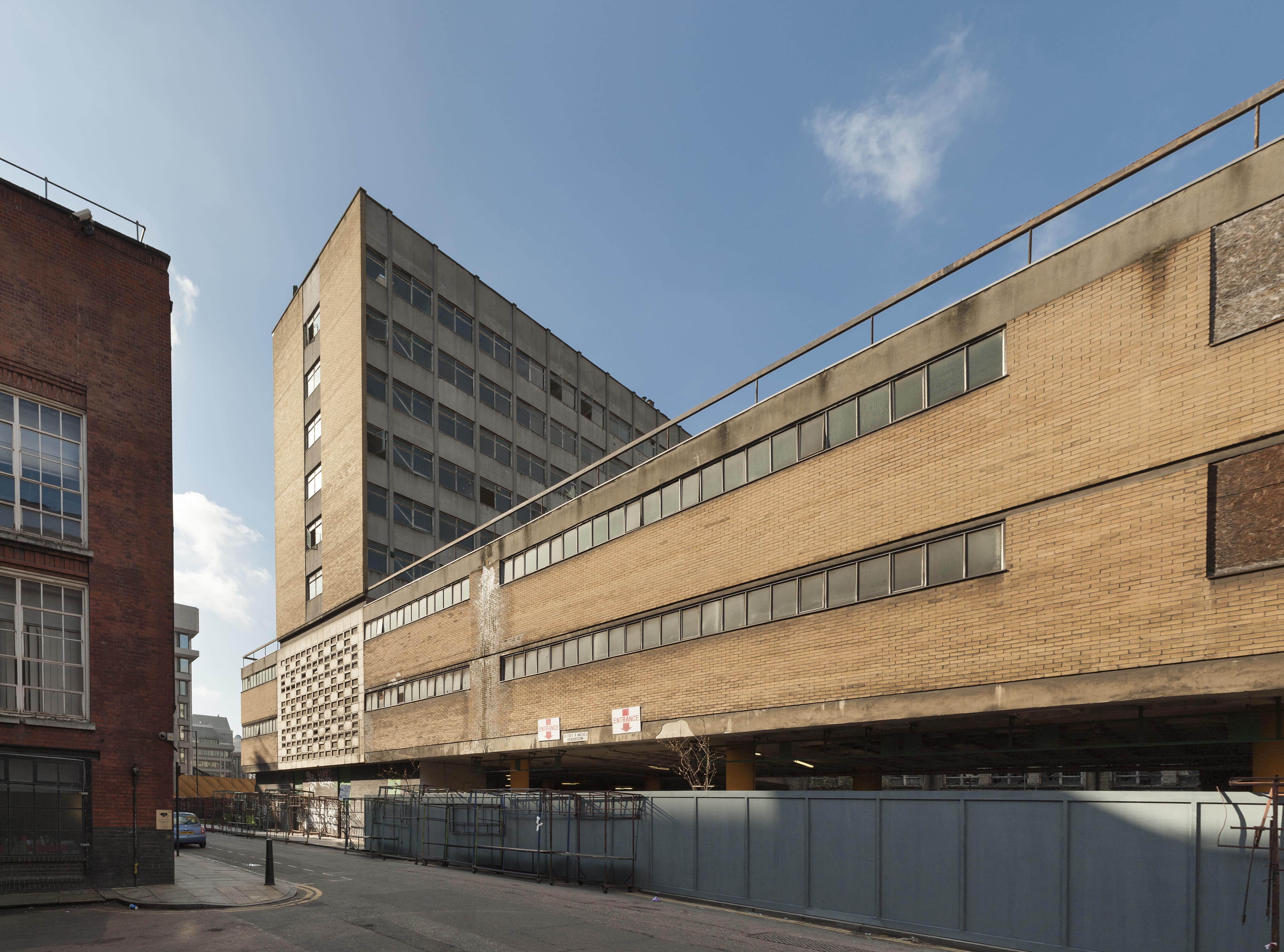
"file": "https://surveyoflondon.org/media/uploads/features/1047/Natwest%204_CWL3bFB.jpg",
"description": "One of four pictures taken in 2011 of the then-empty Natwest Bank Cheque Clearing Centre which stood on the Goodman's Fields site at the corner of Alie Street and Leman Street.",
"copyright": false,
"created": "2019-01-28"
},
{
"id": 1724,
"title": "66 Alie Street from the south-west in 2017",
"author": {
"id": 27,
"username": "DerekKendall"
},
"feature": {
"id": 1047,
"type": "Feature",
"geometry": {
"type": "MultiPolygon",
"coordinates": [
[
[
[
-0.070507285693422,
51.51383090440113
],
[
-0.069707737237537,
51.514184751452724
],
[
-0.069322145577777,
51.513819239326324
],
[
-0.069477910961367,
51.5137516492373
],
[
-0.069449902184866,
51.51371686688633
],
[
-0.069614131036717,
51.513655768609844
],
[
-0.069648590074739,
51.51369101943822
],
[
-0.070222944111541,
51.513488026703634
],
[
-0.070278058062727,
51.513554501477984
],
[
-0.070306902534867,
51.51354356766092
],
[
-0.070379446811545,
51.513631553258705
],
[
-0.070350540554201,
51.51364190115836
],
[
-0.070507285693422,
51.51383090440113
]
]
]
]
},
"properties": {
"b_number": "66",
"b_name": "Premier Inn, 66 Alie Street",
"street": "Alie Street",
"address": "Premier Inn, 66 Alie Street",
"feature_type": "WHITECHAPEL_BUILDING",
"count": 14,
"search_str": "Premier Inn, 66 Alie Street"
},
"tags": []
},
"file": "https://surveyoflondon.org/media/uploads/features/1047/SoL%20Whitechapel%20101539.jpg",
"description": "",
"copyright": true,
"created": "2020-06-01"
}
]
}