HTTP 200 OK
Allow: GET, HEAD, OPTIONS
Content-Type: application/json
Vary: Accept
{
"count": 1747,
"next": "https://surveyoflondon.org/api/v1/images/?format=api&page=80",
"previous": "https://surveyoflondon.org/api/v1/images/?format=api&page=78",
"results": [
{
"id": 1697,
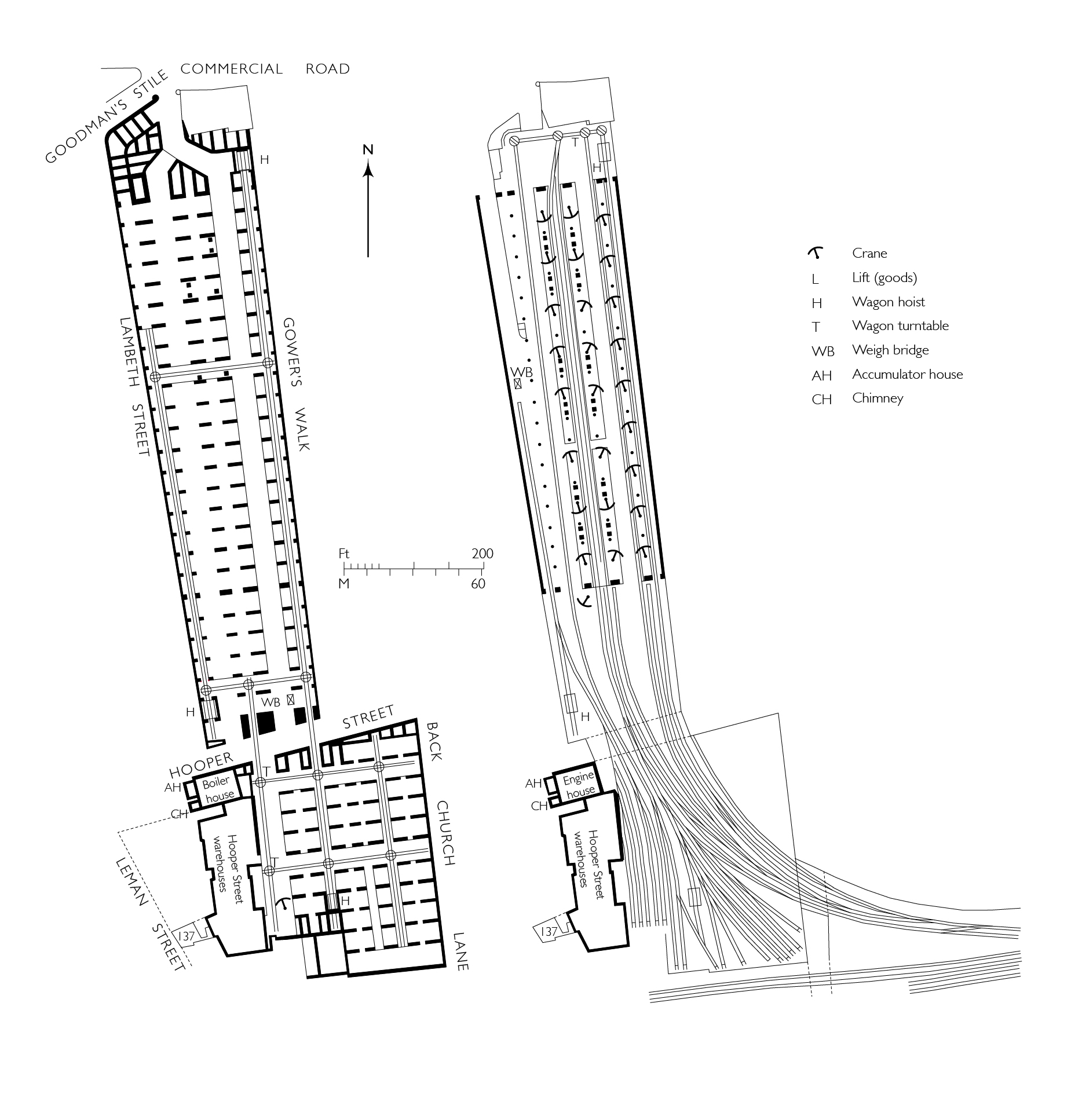
"title": "Commercial Road Goods Depot, plans at street-level (left) and upper rail-level (right)",
"author": {
"id": 82,
"username": "HelenJones"
},
"feature": {
"id": 1048,
"type": "Feature",
"geometry": {
"type": "MultiPolygon",
"coordinates": [
[
[
[
-0.069533901353918,
51.51425898768582
],
[
-0.068951227800474,
51.51452557120583
],
[
-0.068981900416026,
51.51455070932869
],
[
-0.0688166585981,
51.5146266832079
],
[
-0.068785386209583,
51.5146015041635
],
[
-0.068653255990076,
51.514661911269
],
[
-0.068508500301173,
51.51453712412918
],
[
-0.068473342844002,
51.514104588728905
],
[
-0.06844247211215,
51.514105667028474
],
[
-0.068432133336865,
51.51402775838509
],
[
-0.068465375478701,
51.51402504231887
],
[
-0.068458861292615,
51.51396650510224
],
[
-0.069020796129966,
51.51373596607887
],
[
-0.069533901353918,
51.51425898768582
]
]
]
]
},
"properties": {
"b_number": "",
"b_name": "Meranti House",
"street": "Alie Street",
"address": "Mernti House, Alie Street",
"feature_type": "WHITECHAPEL_BUILDING",
"count": 11,
"search_str": "Meranti House"
},
"tags": []
},
"file": "https://surveyoflondon.org/media/uploads/features/1048/commercial%20road%202%20amended%202.jpg",
"description": "(drawn by Helen Jones for the Survey of London based on drawings by Tim Smith)",
"copyright": true,
"created": "2020-05-11"
},
{
"id": 1691,
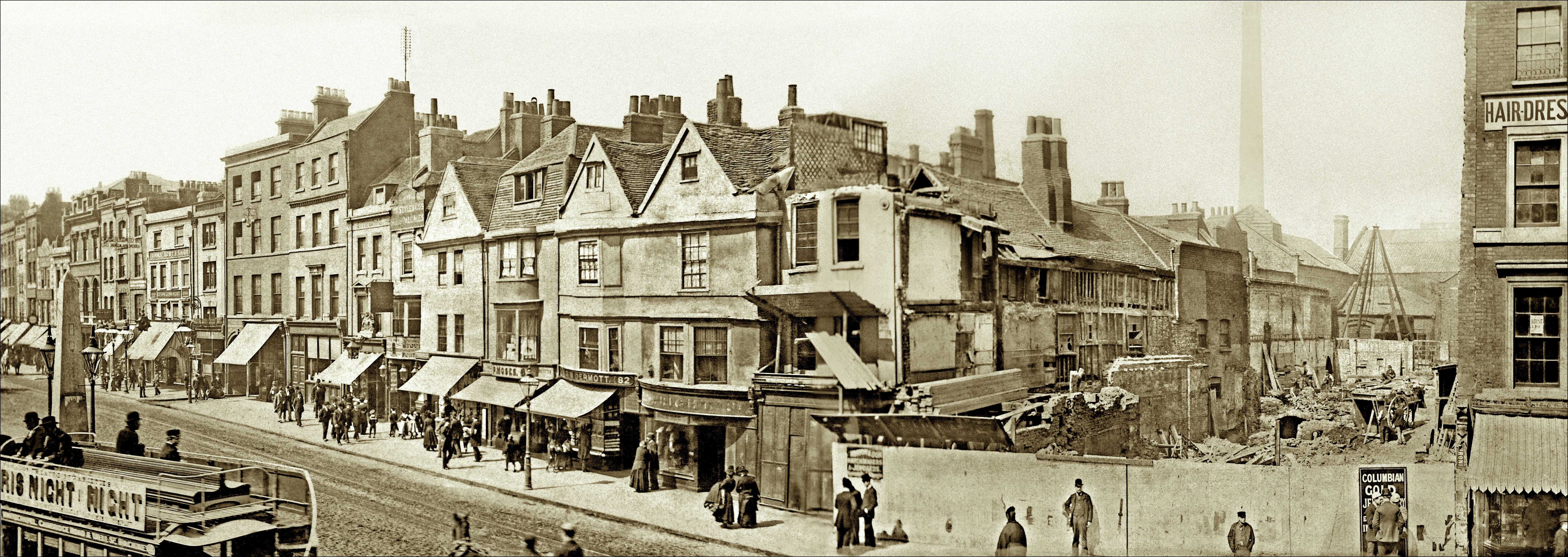
"title": "Whitechapel High Street's north side in 1890 from the east",
"author": {
"id": 280,
"username": "PMarriage"
},
"feature": {
"id": 1743,
"type": "Feature",
"geometry": {
"type": "MultiPolygon",
"coordinates": [
[
[
[
-0.073411821699579,
51.51467674446512
],
[
-0.072731355303774,
51.514916811528764
],
[
-0.07188498637862,
51.51521927010499
],
[
-0.071325614752325,
51.51544095498937
],
[
-0.070774639967226,
51.515605952693505
],
[
-0.069847461990603,
51.51600844129137
],
[
-0.069612775522787,
51.51611554197248
],
[
-0.069514933844418,
51.51603777987923
],
[
-0.07062003013613,
51.51555119093597
],
[
-0.071250881804969,
51.51535269561576
],
[
-0.071777920220375,
51.515135083966406
],
[
-0.073328190602561,
51.5145926917498
],
[
-0.073411821699579,
51.51467674446512
]
]
]
]
},
"properties": {
"b_number": "",
"b_name": "",
"street": "",
"address": "Whitechapel High Street",
"feature_type": "PLACE",
"count": 14,
"search_str": "Whitechapel High Street"
},
"tags": []
},
"file": "https://surveyoflondon.org/media/uploads/features/1743/P28697%20Whitechapel%20Library-1q_FLAT.jpeg",
"description": "Philip Marriage has stitched together two photographs of 1890, when Whitechapel Library was set to be built, to create this panorama. Reproduced by courtesy of Tower Hamlets Local History Library and Archives, which retains copyright.",
"copyright": true,
"created": "2020-04-28"
},
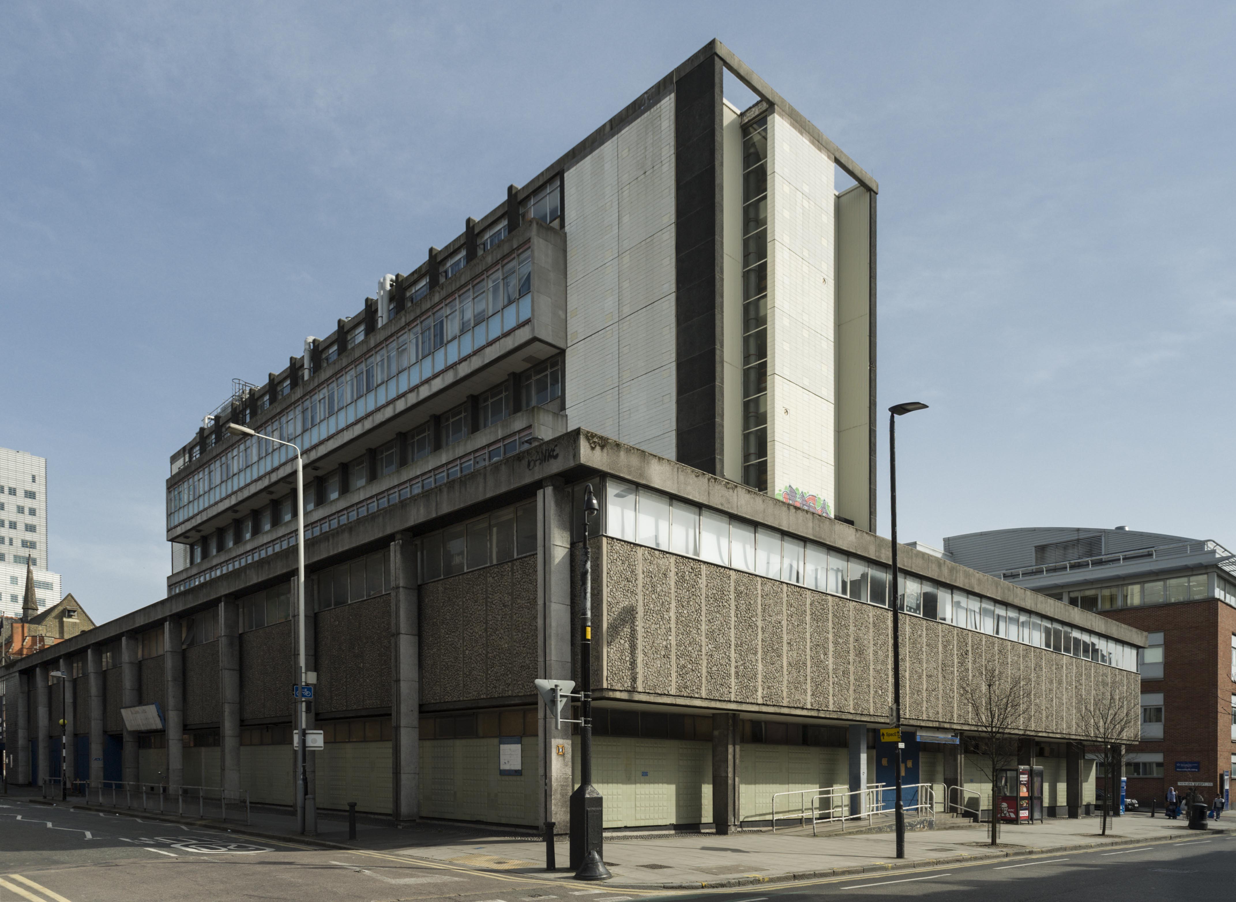
{
"id": 1810,
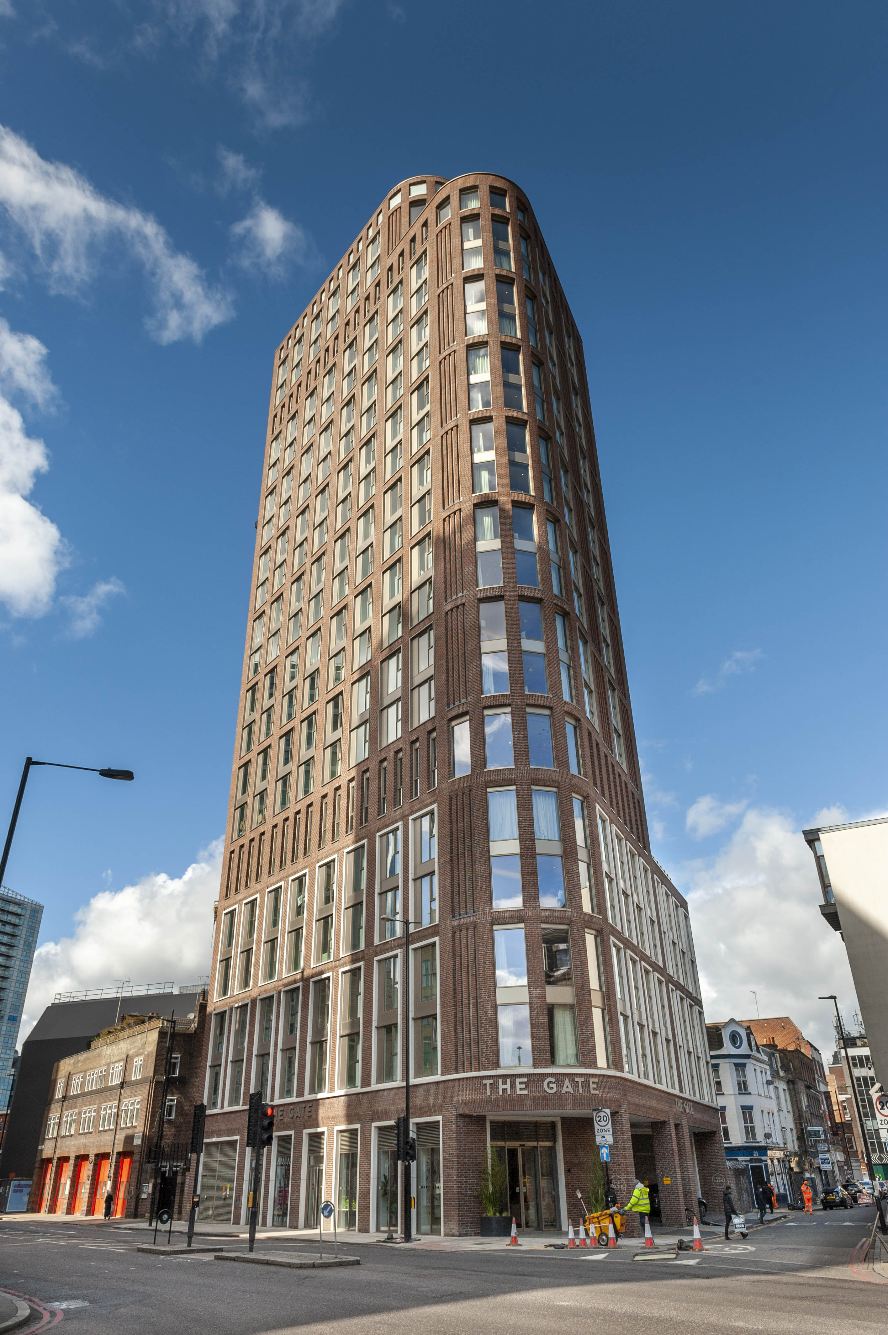
"title": "Gate Hotel and flats above, built 2018–19, from the south-east in 2021",
"author": {
"id": 27,
"username": "DerekKendall"
},
"feature": {
"id": 102,
"type": "Feature",
"geometry": {
"type": "MultiPolygon",
"coordinates": [
[
[
[
-0.068884991325227,
51.51509176890641
],
[
-0.068884964761477,
51.515091771690116
],
[
-0.068794658458709,
51.51512331365302
],
[
-0.068755208747082,
51.51507437068053
],
[
-0.068763951154488,
51.515060519662065
],
[
-0.06878690364361,
51.51504817492868
],
[
-0.068894901526045,
51.51504995339762
],
[
-0.068909858606256,
51.515082006494964
],
[
-0.068884991325227,
51.51509176890641
]
]
]
]
},
"properties": {
"b_number": "27",
"b_name": "",
"street": "Commercial Road",
"address": "27 Commercial Road",
"feature_type": "WHITECHAPEL_BUILDING",
"count": 10,
"search_str": "27 Commercial Road"
},
"tags": []
},
"file": "https://surveyoflondon.org/media/uploads/features/102/SoL%20Whitechapel%20102865.jpg",
"description": "",
"copyright": true,
"created": "2021-03-30"
},
{
"id": 1569,
"title": "Sugar House, ornament detail, 2017",
"author": {
"id": 27,
"username": "DerekKendall"
},
"feature": {
"id": 1264,
"type": "Feature",
"geometry": {
"type": "MultiPolygon",
"coordinates": [
[
[
[
-0.069331963951854,
51.51229594729769
],
[
-0.069137875560046,
51.512351392206085
],
[
-0.068952695054468,
51.51210160696183
],
[
-0.06877706008966,
51.51212449662561
],
[
-0.068766393531184,
51.5121102580591
],
[
-0.068775926288607,
51.51210689932468
],
[
-0.068782151200721,
51.51209293893689
],
[
-0.068742154431936,
51.5120172780914
],
[
-0.068763790231903,
51.51199419623458
],
[
-0.069027145444056,
51.51193993762725
],
[
-0.06905682792721,
51.51194862974888
],
[
-0.069331963951854,
51.51229594729769
]
]
]
]
},
"properties": {
"b_number": "99",
"b_name": "Sugar House, 99 Leman Street",
"street": "Leman Street",
"address": "Sugar House, 99 Leman Street",
"feature_type": "WHITECHAPEL_BUILDING",
"count": 21,
"search_str": "Sugar House, 99 Leman Street"
},
"tags": [
"Co-operative Wholesale Society"
]
},
"file": "https://surveyoflondon.org/media/uploads/features/1264/SoL%20Whitechapel%20101092.jpg",
"description": "",
"copyright": true,
"created": "2019-03-20"
},
{
"id": 1649,
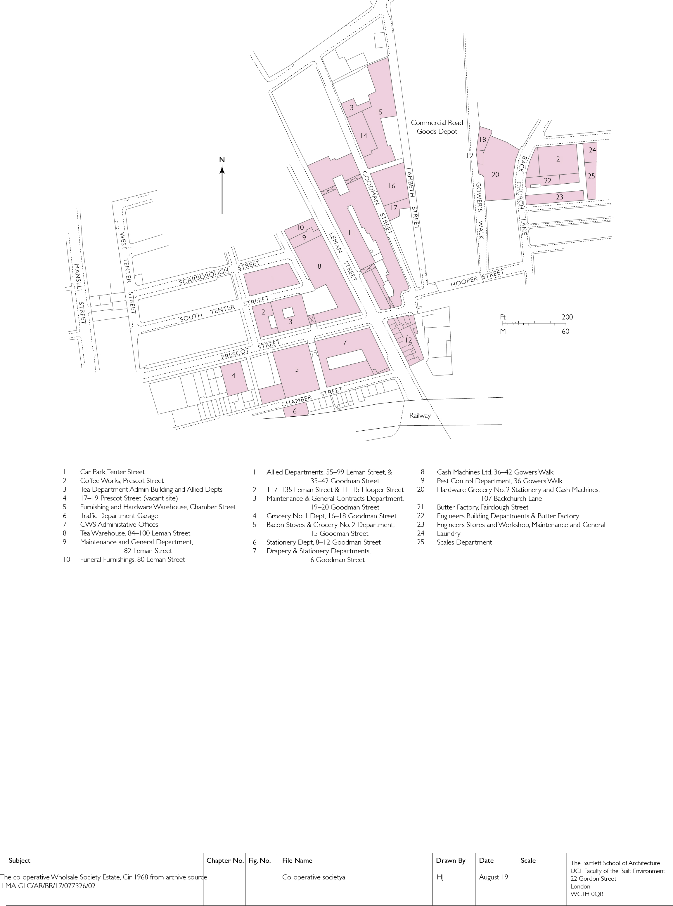
"title": "The Co-operative Wholesale Society estate in 1968",
"author": {
"id": 82,
"username": "HelenJones"
},
"feature": {
"id": 1264,
"type": "Feature",
"geometry": {
"type": "MultiPolygon",
"coordinates": [
[
[
[
-0.069331963951854,
51.51229594729769
],
[
-0.069137875560046,
51.512351392206085
],
[
-0.068952695054468,
51.51210160696183
],
[
-0.06877706008966,
51.51212449662561
],
[
-0.068766393531184,
51.5121102580591
],
[
-0.068775926288607,
51.51210689932468
],
[
-0.068782151200721,
51.51209293893689
],
[
-0.068742154431936,
51.5120172780914
],
[
-0.068763790231903,
51.51199419623458
],
[
-0.069027145444056,
51.51193993762725
],
[
-0.06905682792721,
51.51194862974888
],
[
-0.069331963951854,
51.51229594729769
]
]
]
]
},
"properties": {
"b_number": "99",
"b_name": "Sugar House, 99 Leman Street",
"street": "Leman Street",
"address": "Sugar House, 99 Leman Street",
"feature_type": "WHITECHAPEL_BUILDING",
"count": 21,
"search_str": "Sugar House, 99 Leman Street"
},
"tags": [
"Co-operative Wholesale Society"
]
},
"file": "https://surveyoflondon.org/media/uploads/features/1264/co-operative%20society%20estate%20amended%201.jpg",
"description": "",
"copyright": true,
"created": "2019-08-23"
},
{
"id": 1709,
"title": "Gowers Walk and the Johnny Walker Warehouse",
"author": {
"id": 153,
"username": "danny"
},
"feature": {
"id": 996,
"type": "Feature",
"geometry": {
"type": "MultiPolygon",
"coordinates": [
[
[
[
-0.067861838065609,
51.51475347064
],
[
-0.06786453313317,
51.51478234806407
],
[
-0.067585581780586,
51.51476507543967
],
[
-0.067588509051496,
51.51474607517389
],
[
-0.067420739755857,
51.51473600887351
],
[
-0.067418669259981,
51.51475690079008
],
[
-0.067243977243653,
51.51474606363514
],
[
-0.067247831877495,
51.514720711350456
],
[
-0.067148423655411,
51.514715895823834
],
[
-0.067164508046975,
51.51459719968502
],
[
-0.067169468365816,
51.51455902742509
],
[
-0.067267424237092,
51.514565373164125
],
[
-0.067284203490366,
51.51446875999768
],
[
-0.067487888007954,
51.514480206746164
],
[
-0.067487831570817,
51.51448159696675
],
[
-0.067481262401076,
51.514514394275835
],
[
-0.067633797500801,
51.51452521712492
],
[
-0.067640049851402,
51.51449178362331
],
[
-0.067640050183764,
51.51449178093463
],
[
-0.067838967383754,
51.51450488151706
],
[
-0.067828248265366,
51.51461731190957
],
[
-0.067887142834602,
51.51462052176631
],
[
-0.06789972538097,
51.51475577751923
],
[
-0.067861838065609,
51.51475347064
]
]
]
]
},
"properties": {
"b_number": "52 to 58",
"b_name": "52 to 58 Commercial Road",
"street": "Commercial Road",
"address": "52 to 58 Commercial Road",
"feature_type": "WHITECHAPEL_BUILDING",
"count": 10,
"search_str": "52 to 58 Commercial Road"
},
"tags": []
},
"file": "https://surveyoflondon.org/media/uploads/features/996/Gowers%20Walk%202006.jpg",
"description": "A view of the former Johnny Walker warehouse on Commercial Road, now the campus of Hult University London, from the north end of Gowers Walk.",
"copyright": false,
"created": "2020-05-13"
},
{
"id": 1710,
"title": "Gowers Walk and the Johnny Walker Warehouse",
"author": {
"id": 153,
"username": "danny"
},
"feature": {
"id": 996,
"type": "Feature",
"geometry": {
"type": "MultiPolygon",
"coordinates": [
[
[
[
-0.067861838065609,
51.51475347064
],
[
-0.06786453313317,
51.51478234806407
],
[
-0.067585581780586,
51.51476507543967
],
[
-0.067588509051496,
51.51474607517389
],
[
-0.067420739755857,
51.51473600887351
],
[
-0.067418669259981,
51.51475690079008
],
[
-0.067243977243653,
51.51474606363514
],
[
-0.067247831877495,
51.514720711350456
],
[
-0.067148423655411,
51.514715895823834
],
[
-0.067164508046975,
51.51459719968502
],
[
-0.067169468365816,
51.51455902742509
],
[
-0.067267424237092,
51.514565373164125
],
[
-0.067284203490366,
51.51446875999768
],
[
-0.067487888007954,
51.514480206746164
],
[
-0.067487831570817,
51.51448159696675
],
[
-0.067481262401076,
51.514514394275835
],
[
-0.067633797500801,
51.51452521712492
],
[
-0.067640049851402,
51.51449178362331
],
[
-0.067640050183764,
51.51449178093463
],
[
-0.067838967383754,
51.51450488151706
],
[
-0.067828248265366,
51.51461731190957
],
[
-0.067887142834602,
51.51462052176631
],
[
-0.06789972538097,
51.51475577751923
],
[
-0.067861838065609,
51.51475347064
]
]
]
]
},
"properties": {
"b_number": "52 to 58",
"b_name": "52 to 58 Commercial Road",
"street": "Commercial Road",
"address": "52 to 58 Commercial Road",
"feature_type": "WHITECHAPEL_BUILDING",
"count": 10,
"search_str": "52 to 58 Commercial Road"
},
"tags": []
},
"file": "https://surveyoflondon.org/media/uploads/features/996/Gowers%20Walk%202006_rCf4B82.jpg",
"description": "A view of the former Johnny Walker warehouse on Commercial Road, now the campus of Hult University London, from the north end of Gowers Walk.",
"copyright": false,
"created": "2020-05-13"
},
{
"id": 1704,
"title": "DLR viaduct construction over Leman Street",
"author": {
"id": 153,
"username": "danny"
},
"feature": {
"id": 1284,
"type": "Feature",
"geometry": {
"type": "MultiPolygon",
"coordinates": [
[
[
[
-0.068500275953618,
51.51107508505472
],
[
-0.068478612819023,
51.51106496949243
],
[
-0.068414202464355,
51.51097498722599
],
[
-0.068521626072007,
51.51097035427303
],
[
-0.068532473079143,
51.511074986716515
],
[
-0.068500275953618,
51.51107508505472
]
]
]
]
},
"properties": {
"b_number": "",
"b_name": "",
"street": "Leman Street",
"address": "Pier in middle of Leman Street",
"feature_type": "WHITECHAPEL_BUILDING",
"count": 12,
"search_str": "Pier in middle of Leman Street"
},
"tags": []
},
"file": "https://surveyoflondon.org/media/uploads/features/1284/DLR%20Construction%20Leman%20St.jpg",
"description": "This image shows the construction of the DLR viadcut over Leman Street circa 1985.",
"copyright": false,
"created": "2020-05-12"
},
{
"id": 1089,
"title": "View of the nave looking towards the north aisle, December 2017",
"author": {
"id": 27,
"username": "DerekKendall"
},
"feature": {
"id": 1063,
"type": "Feature",
"geometry": {
"type": "MultiPolygon",
"coordinates": [
[
[
[
-0.060845062076888,
51.517232461665024
],
[
-0.060858061981046,
51.517297370705585
],
[
-0.060852072355982,
51.51729777282787
],
[
-0.060850777279358,
51.517292038613824
],
[
-0.060836585058279,
51.51723251416014
],
[
-0.060769976187858,
51.51723703364601
],
[
-0.060780310614954,
51.51729938465229
],
[
-0.060851422100426,
51.517294893689865
],
[
-0.060852072355982,
51.51729777282787
],
[
-0.060780756007888,
51.51730231203111
],
[
-0.060433008250066,
51.51733065140396
],
[
-0.060436612097579,
51.51734759826428
],
[
-0.060301835648786,
51.517358754570346
],
[
-0.060301267692063,
51.517334324990614
],
[
-0.060276367898553,
51.517334550322296
],
[
-0.060277606963858,
51.51738784759974
],
[
-0.060240911793285,
51.51738817966408
],
[
-0.060239603561777,
51.51733190531689
],
[
-0.060233709433579,
51.517328890670484
],
[
-0.060224675865392,
51.517324270305814
],
[
-0.06015408706542,
51.51728816646581
],
[
-0.060146994469308,
51.51728968696465
],
[
-0.06013876083629,
51.51729145207641
],
[
-0.060122232338685,
51.51729197252953
],
[
-0.060108489079552,
51.51729240527865
],
[
-0.060095089193358,
51.517291262708895
],
[
-0.060083703724374,
51.51729029190144
],
[
-0.060071883086905,
51.51728644484157
],
[
-0.060064540680754,
51.517282150214506
],
[
-0.060058159323826,
51.51727491549124
],
[
-0.060055164331108,
51.517266693493994
],
[
-0.060055745593556,
51.51725957394812
],
[
-0.060059185744876,
51.51725076287493
],
[
-0.060064720251821,
51.51724301807266
],
[
-0.060073694330703,
51.517237266202336
],
[
-0.060084008477322,
51.51723065542268
],
[
-0.060097749600684,
51.51722563043536
],
[
-0.060110820839004,
51.517222752616206
],
[
-0.060124043459833,
51.517219841466186
],
[
-0.060189323543314,
51.51717326471942
],
[
-0.060230524081512,
51.51717027080275
],
[
-0.060225029840865,
51.51714083975863
],
[
-0.060123966783513,
51.51714818367497
],
[
-0.060109355845798,
51.51706991604146
],
[
-0.060759990305139,
51.51701795039293
],
[
-0.060811901066283,
51.51703520053784
],
[
-0.060831243559519,
51.51714443032851
],
[
-0.060823879564995,
51.51714494230656
],
[
-0.060806280310304,
51.517037602197114
],
[
-0.060758637924026,
51.51702144683871
],
[
-0.060293715895444,
51.517058443881275
],
[
-0.060305285997092,
51.51711767437194
],
[
-0.060380056450023,
51.51711283445328
],
[
-0.060382025685871,
51.5171233828903
],
[
-0.060648003222123,
51.51710939602032
],
[
-0.060636939828746,
51.517031131377244
],
[
-0.060684659737861,
51.51702734366158
],
[
-0.060703670471419,
51.51713214159525
],
[
-0.060746477467265,
51.51712961322092
],
[
-0.060749678508541,
51.517150266791134
],
[
-0.060831225907887,
51.517144845854745
],
[
-0.060845060388772,
51.51723245093664
],
[
-0.060845062076888,
51.517232461665024
]
]
]
]
},
"properties": {
"b_number": "",
"b_name": "",
"street": "Stepney Way",
"address": "St Philip's Church Library and the Royal London Museum",
"feature_type": "WHITECHAPEL_BUILDING",
"count": 52,
"search_str": "St Philip's Church Library and the Royal London Museum"
},
"tags": []
},
"file": "https://surveyoflondon.org/media/uploads/features/1063/SoL%20Whitechapel%20101669.jpg",
"description": "",
"copyright": true,
"created": "2018-01-22"
},
{
"id": 1701,
"title": "Corner of John Fisher Street and Royal Mint Street, 1980s",
"author": {
"id": 153,
"username": "danny"
},
"feature": {
"id": 1341,
"type": "Feature",
"geometry": {
"type": "MultiPolygon",
"coordinates": [
[
[
[
-0.069674995219055,
51.510563447847346
],
[
-0.069470567670017,
51.51060542474273
],
[
-0.069427122021502,
51.51052602242747
],
[
-0.069442800926851,
51.51052243635141
],
[
-0.069431192855565,
51.51050552752134
],
[
-0.069544490086559,
51.510480187394315
],
[
-0.069622428211284,
51.5105273163852
],
[
-0.069656877702612,
51.51052349248554
],
[
-0.069674995219055,
51.510563447847346
]
]
]
]
},
"properties": {
"b_number": "55",
"b_name": "Tower Mint Apartments",
"street": "Royal Mint Street",
"address": "Tower Mint Apartments, 55 Royal Mint Street (with 84 John Fisher Street)",
"feature_type": "WHITECHAPEL_BUILDING",
"count": 6,
"search_str": "Tower Mint Apartments"
},
"tags": []
},
"file": "https://surveyoflondon.org/media/uploads/features/1341/Corner%20JFS%20and%20RMS.jpg",
"description": "This is a view of two buildings which comprised two retail premises - a cafe (right) once known as the Model Inn, and a newsagents / confectioners (left) which had been abandoned and derelict from the early 70s. Both these buildings were subsequently demolished and it was only some years later, that the current building, Tower Apartments was constructed there. \n\nIn the bottom left corner of the image, the roofs of two garages, which were on the neighbouring Peabody Whitechapel Estate, are visible. These stood on John Fisher Street and were demolished to make way for the Peabody owned-community building at No 80 John Fisher Street.\n\nIn the background, the Docklands Railway Bank Extension is under construction, and a train on the London Tilbury and Southend Line of British Rail / National Railways can be seen. \n\nOn the other side of the viaduct rises the Cooperative Bank Building which spans the land between Chamber Street and 9 Prescot Street. \n\nIn front of the Cooperative Bank buildings, is an office building with a copper coloured feature on the roof at the left end. This was subsequently converted into a Travel Lodge Hotel and is situated at 6-13 Chamber Street.\n\nTo the right of the red hoarding on the other (north) side of Royal Mint Street can be seen a \"cannon\" style bollard which is the entrance to the alleyway known as Abel's Buildings which runs between Royal Mint Street and Chamber Street below the railway viaduct.\n\nOther buildings visible in the background include the former Abbey National Cheque Processing Centre, now the Royal College of Psychiatrists HQ (the one with the stone arch features) and, to the left of that, a former office building which was later converted into a Premier Inn. \n\nRising above that, the building with the glass and maroon panels at the corners is Lloyd's Chambers, an office building, now (2020) undergoing refurbishment, in Goodman's Yard.\n",
"copyright": false,
"created": "2020-05-12"
},
{
"id": 1467,
"title": "The Original School Building",
"author": {
"id": 153,
"username": "danny"
},
"feature": {
"id": 1296,
"type": "Feature",
"geometry": {
"type": "MultiPolygon",
"coordinates": [
[
[
[
-0.071706015667423,
51.51096836077219
],
[
-0.071841028671068,
51.51094484938125
],
[
-0.07184526721746,
51.510955445567966
],
[
-0.07186219920978,
51.510953969556034
],
[
-0.071872203924443,
51.51098337431844
],
[
-0.07185618379654,
51.51098545013041
],
[
-0.071892753874241,
51.51107377220918
],
[
-0.071760673580627,
51.511094407858565
],
[
-0.071706015667423,
51.51096836077219
]
]
]
]
},
"properties": {
"b_number": "62",
"b_name": "De Mazenod House, 62 Chamber Street",
"street": "Chamber Street",
"address": "De Mazenod House, 62 Chamber Street",
"feature_type": "WHITECHAPEL_BUILDING",
"count": 9,
"search_str": "De Mazenod House, 62 Chamber Street"
},
"tags": []
},
"file": "https://surveyoflondon.org/media/uploads/features/1296/Old%20School%204.jpg",
"description": "One of the upper floors of the original Catholic Tower Hill School that occupied this purpose built school building until the school moved in late 1969 to new school buildings in St Mark Street when the school became English Martyrs.",
"copyright": true,
"created": "2018-12-01"
},
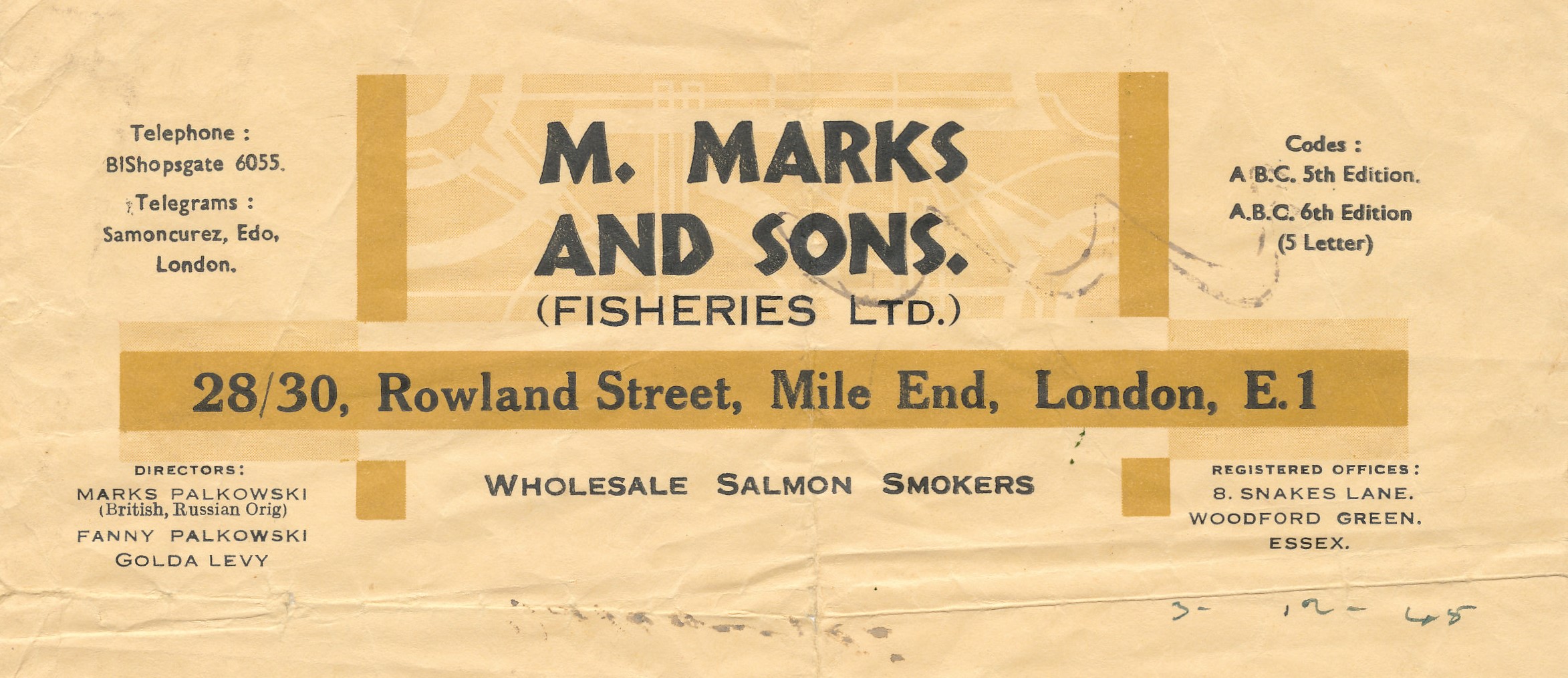
{
"id": 1383,
"title": "Marks of the Lane smoke hole letterhead, c1950s",
"author": {
"id": 252,
"username": "mark3"
},
"feature": {
"id": 1742,
"type": "Feature",
"geometry": {
"type": "MultiPolygon",
"coordinates": [
[
[
[
-0.076387722492951,
51.516257872286374
],
[
-0.07580974439088,
51.51649846859169
],
[
-0.075744693982384,
51.51651411423466
],
[
-0.075332716624042,
51.51665341173461
],
[
-0.075277819023276,
51.516667372076085
],
[
-0.074429584483841,
51.51681699796736
],
[
-0.074402209988697,
51.516763242480046
],
[
-0.075229889371391,
51.51661092868018
],
[
-0.074836715281391,
51.516135055700595
],
[
-0.074917049606191,
51.51611135328064
],
[
-0.075312012611936,
51.51658616747119
],
[
-0.075695505281233,
51.51646463519818
],
[
-0.075779072585588,
51.51644696856364
],
[
-0.076328753388395,
51.516209038390684
],
[
-0.076387722492951,
51.516257872286374
]
]
]
]
},
"properties": {
"b_number": "",
"b_name": "",
"street": "",
"address": "Petticoat Lane Market",
"feature_type": "PLACE",
"count": 39,
"search_str": "Petticoat Lane Market"
},
"tags": []
},
"file": "https://surveyoflondon.org/media/uploads/features/1742/Smoke%20hole.jpg",
"description": "The site of the family smoke hole that serviced Marks of the Lane Deli (59 Wentworth Street).",
"copyright": false,
"created": "2018-10-28"
},
{
"id": 265,
"title": "Dental Hospital and Institute of Dentistry from the south-west in 2016",
"author": {
"id": 27,
"username": "DerekKendall"
},
"feature": {
"id": 1166,
"type": "Feature",
"geometry": {
"type": "MultiPolygon",
"coordinates": [
[
[
[
-0.062351470894244,
51.51718815629615
],
[
-0.061292929801261,
51.51728379235413
],
[
-0.061222794483401,
51.51696856036261
],
[
-0.062282192019856,
51.516876806223415
],
[
-0.062351470894244,
51.51718815629615
]
]
]
]
},
"properties": {
"b_number": "",
"b_name": "",
"street": "Stepney Way",
"address": "Dental Hospital and Institute of Dentistry",
"feature_type": "WHITECHAPEL_BUILDING",
"count": 13,
"search_str": "Dental Hospital and Institute of Dentistry"
},
"tags": [
"Dental Institute",
"London Hospital",
"Royal London Hospital",
"Stephen Statham & Associates",
"Students' Union"
]
},
"file": "https://surveyoflondon.org/media/uploads/features/1166/SoL%20Whitechapel100137.jpg",
"description": "",
"copyright": true,
"created": "2016-08-17"
},
{
"id": 1768,
"title": "Gower's Walk, view to the south with Chandlery House to the east in 2017",
"author": {
"id": 27,
"username": "DerekKendall"
},
"feature": {
"id": 1005,
"type": "Feature",
"geometry": {
"type": "MultiPolygon",
"coordinates": [
[
[
[
-0.067180798939432,
51.512911920220176
],
[
-0.067624988998484,
51.51289617869746
],
[
-0.067674782792481,
51.51313629851437
],
[
-0.067721744056023,
51.51313289915908
],
[
-0.067755852211198,
51.51322248870878
],
[
-0.067682509657788,
51.51321710704479
],
[
-0.067654590885861,
51.513297328210555
],
[
-0.067516875836223,
51.51328532147534
],
[
-0.067468956763533,
51.51341668205499
],
[
-0.067277526303318,
51.51337909942833
],
[
-0.067137642973819,
51.51333104278721
],
[
-0.067188431523132,
51.51317071067776
],
[
-0.067203219362638,
51.51308470897374
],
[
-0.067183076322121,
51.51292857876673
],
[
-0.067180798939432,
51.512911920220176
]
],
[
[
-0.067402751092455,
51.513321694761274
],
[
-0.067420144835674,
51.51325312417157
],
[
-0.067384587480254,
51.51325045159809
],
[
-0.067384326780274,
51.51323027699892
],
[
-0.067335343500746,
51.513228774201664
],
[
-0.067319383083405,
51.513316147649554
],
[
-0.067402751092455,
51.513321694761274
]
],
[
[
-0.067492150220602,
51.51318475803046
],
[
-0.067522036285235,
51.513084399017174
],
[
-0.067453414453496,
51.51307283525235
],
[
-0.067418954868062,
51.51317590098832
],
[
-0.067492150220602,
51.51318475803046
]
],
[
[
-0.06747986041909,
51.51304058127036
],
[
-0.067475683647445,
51.51294174750583
],
[
-0.067394851036263,
51.51294215421109
],
[
-0.067401211342125,
51.51304206725618
],
[
-0.06747986041909,
51.51304058127036
]
]
]
]
},
"properties": {
"b_number": "40",
"b_name": "Chandlery House, 40 Gower's Walk",
"street": "Gower's Walk",
"address": "Chandlery House, 40 Gower's Walk",
"feature_type": "WHITECHAPEL_BUILDING",
"count": 11,
"search_str": "Chandlery House, 40 Gower's Walk"
},
"tags": []
},
"file": "https://surveyoflondon.org/media/uploads/features/1005/SoL%20Whitechapel%20101035.jpg",
"description": "",
"copyright": true,
"created": "2020-08-04"
},
{
"id": 1827,
"title": "Goulston Street Improvement, plans of sites taken for development in 1877 (drawing by Helen Jones)",
"author": {
"id": 2,
"username": "surveyoflondon"
},
"feature": {
"id": 359,
"type": "Feature",
"geometry": {
"type": "MultiPolygon",
"coordinates": [
[
[
[
-0.074396169724534,
51.51674677293217
],
[
-0.074344918245201,
51.51668771806432
],
[
-0.074415391815644,
51.51667127366158
],
[
-0.074407427802984,
51.51665783673676
],
[
-0.074464842346045,
51.51664692918775
],
[
-0.074451564815962,
51.516627570285934
],
[
-0.074484845350984,
51.516618730970194
],
[
-0.074449462429928,
51.5165697349019
],
[
-0.074495929828979,
51.51655683248676
],
[
-0.074450946678382,
51.516491607819624
],
[
-0.074715152431625,
51.51642099545545
],
[
-0.074553943007666,
51.516244787362865
],
[
-0.074798574993366,
51.51616849501834
],
[
-0.075086564069636,
51.51652796045754
],
[
-0.075099913362563,
51.51652379724113
],
[
-0.075167749140884,
51.51660846832082
],
[
-0.074396169724534,
51.51674677293217
]
]
]
]
},
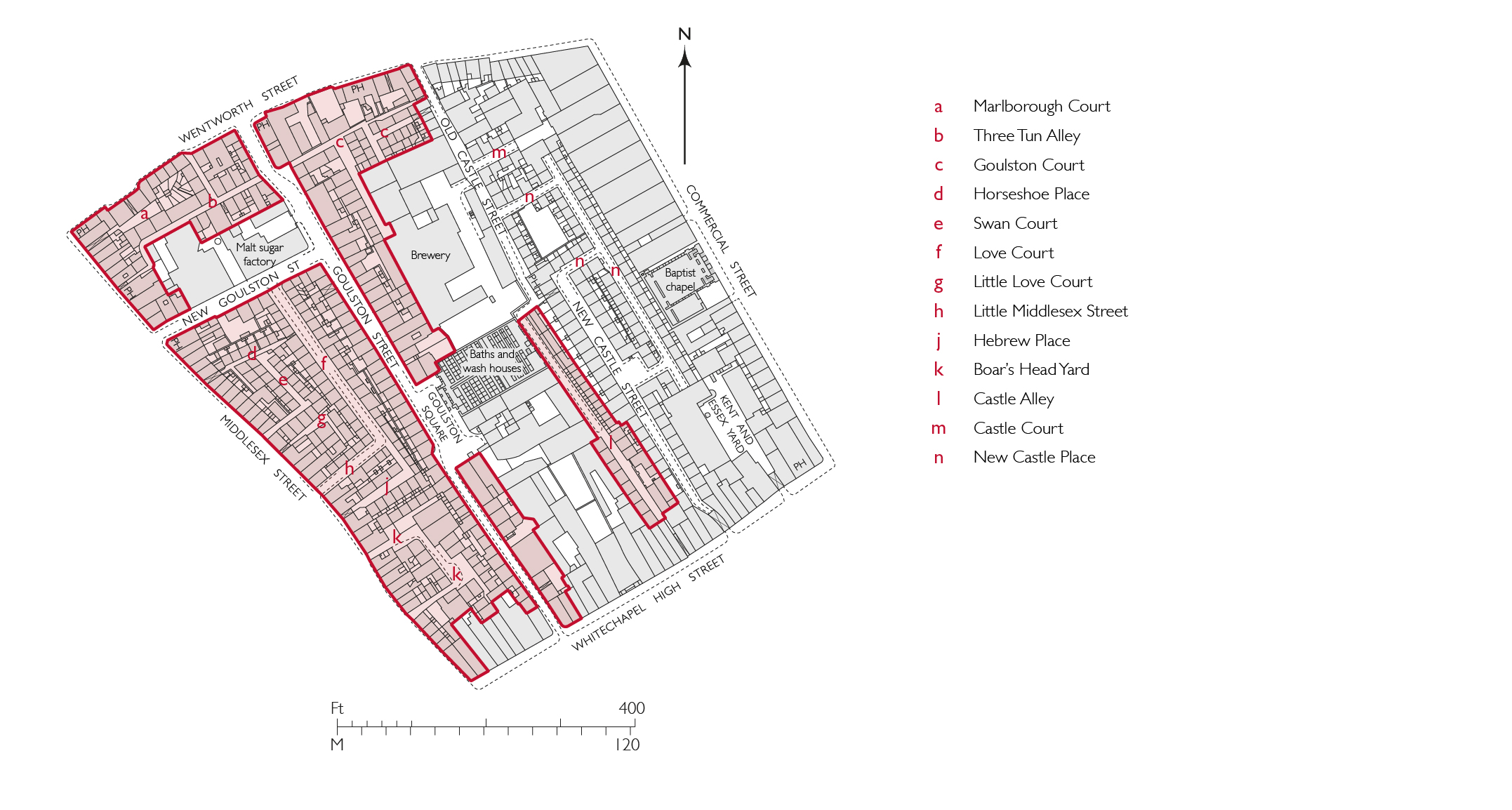
"properties": {
"b_number": "",
"b_name": "Arcadia Court, formerly 90 to 222 Wentworth Dwellings",
"street": "Goulston Street",
"address": "Arcadia Court, formerly 90 to 222 Wentworth Dwellings",
"feature_type": "WHITECHAPEL_BUILDING",
"count": 8,
"search_str": "Arcadia Court, formerly 90 to 222 Wentworth Dwellings"
},
"tags": []
},
"file": "https://surveyoflondon.org/media/uploads/features/359/7.6a%20Goulston%20Street%20redevelopment%20areas%20final.jpg",
"description": "",
"copyright": true,
"created": "2021-05-04"
},
{
"id": 266,
"title": "Dental Hospital and Institute of Dentistry from the north-west in 2016",
"author": {
"id": 27,
"username": "DerekKendall"
},
"feature": {
"id": 1166,
"type": "Feature",
"geometry": {
"type": "MultiPolygon",
"coordinates": [
[
[
[
-0.062351470894244,
51.51718815629615
],
[
-0.061292929801261,
51.51728379235413
],
[
-0.061222794483401,
51.51696856036261
],
[
-0.062282192019856,
51.516876806223415
],
[
-0.062351470894244,
51.51718815629615
]
]
]
]
},
"properties": {
"b_number": "",
"b_name": "",
"street": "Stepney Way",
"address": "Dental Hospital and Institute of Dentistry",
"feature_type": "WHITECHAPEL_BUILDING",
"count": 13,
"search_str": "Dental Hospital and Institute of Dentistry"
},
"tags": [
"Dental Institute",
"London Hospital",
"Royal London Hospital",
"Stephen Statham & Associates",
"Students' Union"
]
},
"file": "https://surveyoflondon.org/media/uploads/features/1166/SoL%20Whitechapel100129.jpg",
"description": "",
"copyright": true,
"created": "2016-08-17"
},
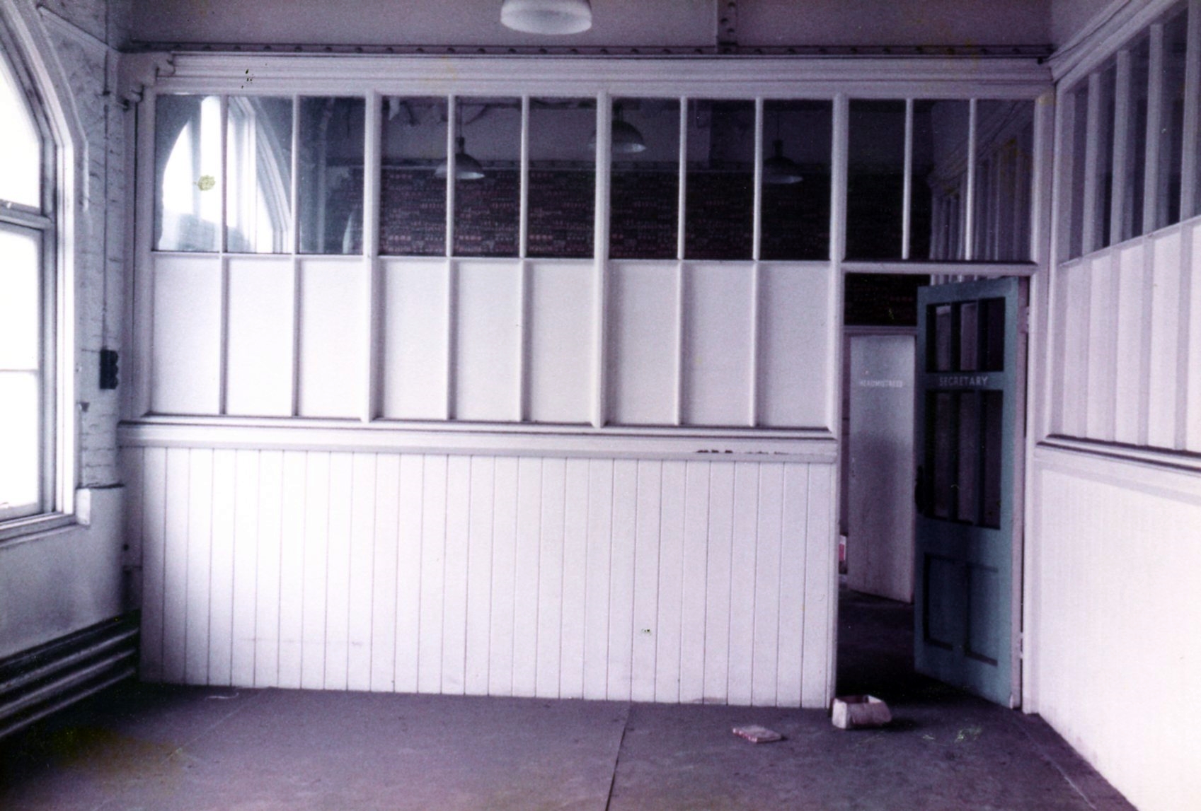
{
"id": 1470,
"title": "Old Tower Hill School",
"author": {
"id": 153,
"username": "danny"
},
"feature": {
"id": 1296,
"type": "Feature",
"geometry": {
"type": "MultiPolygon",
"coordinates": [
[
[
[
-0.071706015667423,
51.51096836077219
],
[
-0.071841028671068,
51.51094484938125
],
[
-0.07184526721746,
51.510955445567966
],
[
-0.07186219920978,
51.510953969556034
],
[
-0.071872203924443,
51.51098337431844
],
[
-0.07185618379654,
51.51098545013041
],
[
-0.071892753874241,
51.51107377220918
],
[
-0.071760673580627,
51.511094407858565
],
[
-0.071706015667423,
51.51096836077219
]
]
]
]
},
"properties": {
"b_number": "62",
"b_name": "De Mazenod House, 62 Chamber Street",
"street": "Chamber Street",
"address": "De Mazenod House, 62 Chamber Street",
"feature_type": "WHITECHAPEL_BUILDING",
"count": 9,
"search_str": "De Mazenod House, 62 Chamber Street"
},
"tags": []
},
"file": "https://surveyoflondon.org/media/uploads/features/1296/Old%20School%207.jpg",
"description": "Headteacher and Secretary's Office inside the original Tower Hill School building. This school was occupied until the school moved to new premises in St Mark's Street and was renamed English Martyrs School in late 1969.",
"copyright": true,
"created": "2018-12-01"
},
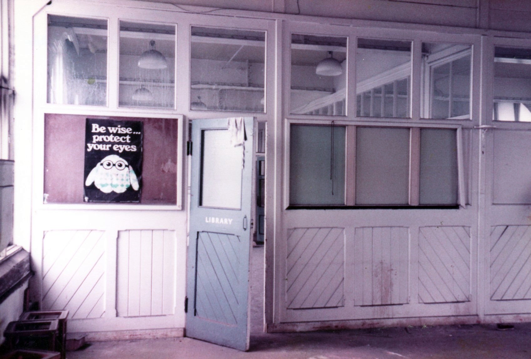
{
"id": 1471,
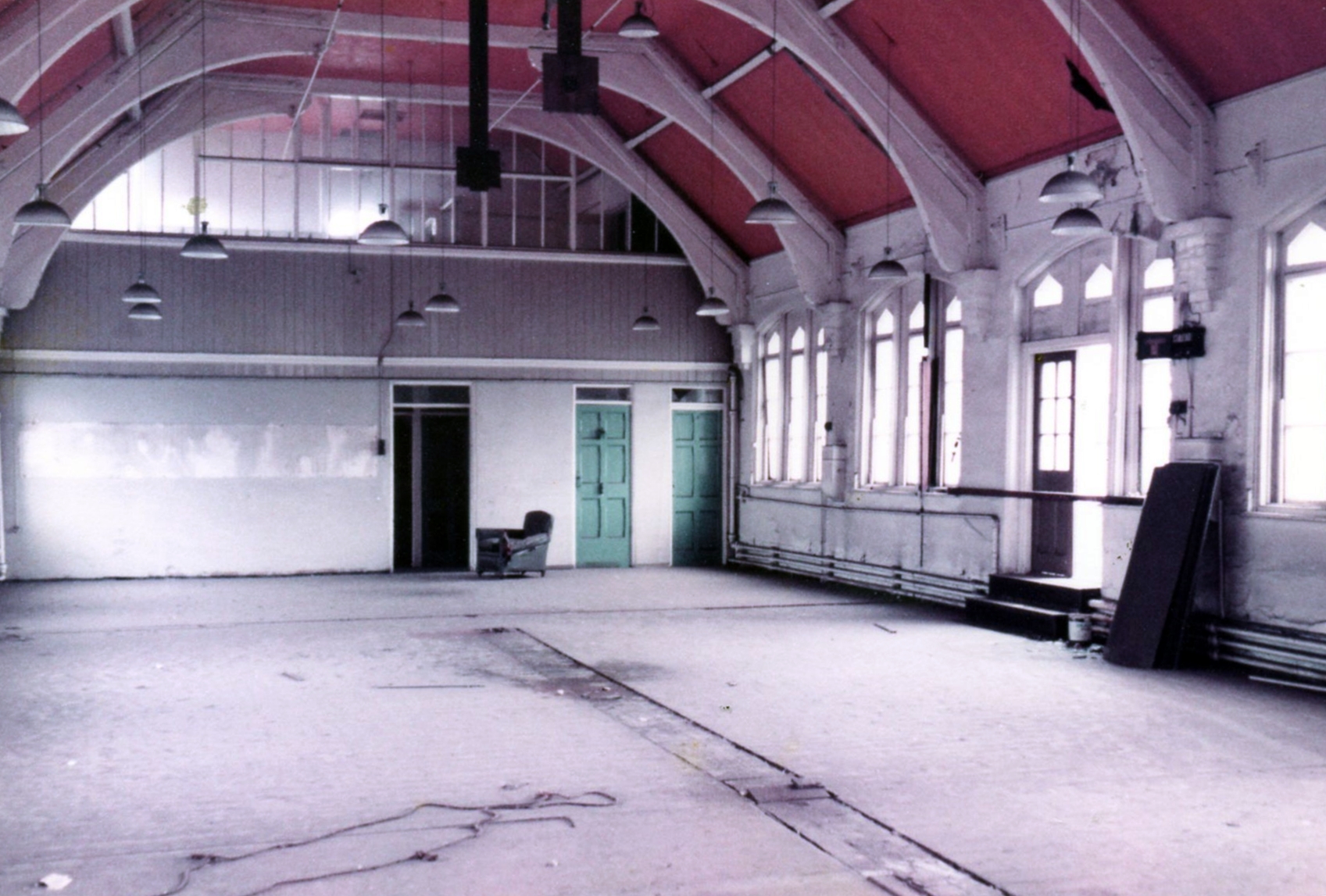
"title": "Old Tower Hill School Building",
"author": {
"id": 153,
"username": "danny"
},
"feature": {
"id": 1296,
"type": "Feature",
"geometry": {
"type": "MultiPolygon",
"coordinates": [
[
[
[
-0.071706015667423,
51.51096836077219
],
[
-0.071841028671068,
51.51094484938125
],
[
-0.07184526721746,
51.510955445567966
],
[
-0.07186219920978,
51.510953969556034
],
[
-0.071872203924443,
51.51098337431844
],
[
-0.07185618379654,
51.51098545013041
],
[
-0.071892753874241,
51.51107377220918
],
[
-0.071760673580627,
51.511094407858565
],
[
-0.071706015667423,
51.51096836077219
]
]
]
]
},
"properties": {
"b_number": "62",
"b_name": "De Mazenod House, 62 Chamber Street",
"street": "Chamber Street",
"address": "De Mazenod House, 62 Chamber Street",
"feature_type": "WHITECHAPEL_BUILDING",
"count": 9,
"search_str": "De Mazenod House, 62 Chamber Street"
},
"tags": []
},
"file": "https://surveyoflondon.org/media/uploads/features/1296/Old%20School%208.jpg",
"description": "Entrance to the library inside the original Tower Hill School building. This school was occupied until the school moved to new premises in St Mark's Street and was renamed English Martyrs School in late 1969.",
"copyright": true,
"created": "2018-12-01"
},
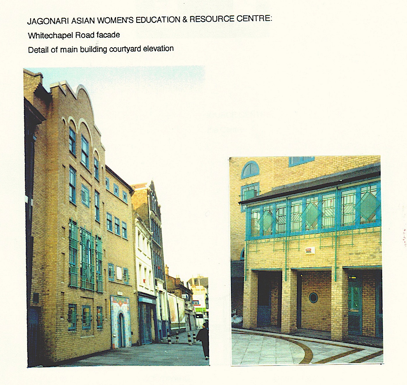
{
"id": 943,
"title": "Jagonari Centre, front elevation and rear courtyard 1989",
"author": {
"id": 18,
"username": "shahedsaleem"
},
"feature": {
"id": 453,
"type": "Feature",
"geometry": {
"type": "MultiPolygon",
"coordinates": [
[
[
[
-0.06387175509906,
51.51844488660313
],
[
-0.063674757657848,
51.51849920648765
],
[
-0.063594819394982,
51.5183863647881
],
[
-0.063789009522268,
51.51833442643744
],
[
-0.06387175509906,
51.51844488660313
]
]
]
]
},
"properties": {
"b_number": "183-185",
"b_name": "Former Jagonari Women's Centre, 183-185 Whitechapel Road",
"street": "Whitechapel Road",
"address": "183-185 Whitechapel Road",
"feature_type": "WHITECHAPEL_BUILDING",
"count": 15,
"search_str": "Former Jagonari Women's Centre, 183-185 Whitechapel Road"
},
"tags": [
"GLC",
"Jagonari",
"Matrix",
"nursery"
]
},
"file": "https://surveyoflondon.org/media/uploads/features/453/front%20mosaic%20and%20courtyard1989.jpeg",
"description": "Photographs of the Jagonari Centre dating from 1989, showing the building soon after its completion in 1986.\n(Image courtesy of Anne Thorne)",
"copyright": false,
"created": "2017-10-24"
},
{
"id": 1769,
"title": "Chandlery House, north end on Gower's Walk in 2017",
"author": {
"id": 27,
"username": "DerekKendall"
},
"feature": {
"id": 1005,
"type": "Feature",
"geometry": {
"type": "MultiPolygon",
"coordinates": [
[
[
[
-0.067180798939432,
51.512911920220176
],
[
-0.067624988998484,
51.51289617869746
],
[
-0.067674782792481,
51.51313629851437
],
[
-0.067721744056023,
51.51313289915908
],
[
-0.067755852211198,
51.51322248870878
],
[
-0.067682509657788,
51.51321710704479
],
[
-0.067654590885861,
51.513297328210555
],
[
-0.067516875836223,
51.51328532147534
],
[
-0.067468956763533,
51.51341668205499
],
[
-0.067277526303318,
51.51337909942833
],
[
-0.067137642973819,
51.51333104278721
],
[
-0.067188431523132,
51.51317071067776
],
[
-0.067203219362638,
51.51308470897374
],
[
-0.067183076322121,
51.51292857876673
],
[
-0.067180798939432,
51.512911920220176
]
],
[
[
-0.067402751092455,
51.513321694761274
],
[
-0.067420144835674,
51.51325312417157
],
[
-0.067384587480254,
51.51325045159809
],
[
-0.067384326780274,
51.51323027699892
],
[
-0.067335343500746,
51.513228774201664
],
[
-0.067319383083405,
51.513316147649554
],
[
-0.067402751092455,
51.513321694761274
]
],
[
[
-0.067492150220602,
51.51318475803046
],
[
-0.067522036285235,
51.513084399017174
],
[
-0.067453414453496,
51.51307283525235
],
[
-0.067418954868062,
51.51317590098832
],
[
-0.067492150220602,
51.51318475803046
]
],
[
[
-0.06747986041909,
51.51304058127036
],
[
-0.067475683647445,
51.51294174750583
],
[
-0.067394851036263,
51.51294215421109
],
[
-0.067401211342125,
51.51304206725618
],
[
-0.06747986041909,
51.51304058127036
]
]
]
]
},
"properties": {
"b_number": "40",
"b_name": "Chandlery House, 40 Gower's Walk",
"street": "Gower's Walk",
"address": "Chandlery House, 40 Gower's Walk",
"feature_type": "WHITECHAPEL_BUILDING",
"count": 11,
"search_str": "Chandlery House, 40 Gower's Walk"
},
"tags": []
},
"file": "https://surveyoflondon.org/media/uploads/features/1005/SoL%20Whitechapel%20101066.jpg",
"description": "",
"copyright": true,
"created": "2020-08-04"
}
]
}