HTTP 200 OK
Allow: GET, HEAD, OPTIONS
Content-Type: application/json
Vary: Accept
{
"count": 1747,
"next": "https://surveyoflondon.org/api/v1/images/?format=api&page=79",
"previous": "https://surveyoflondon.org/api/v1/images/?format=api&page=77",
"results": [
{
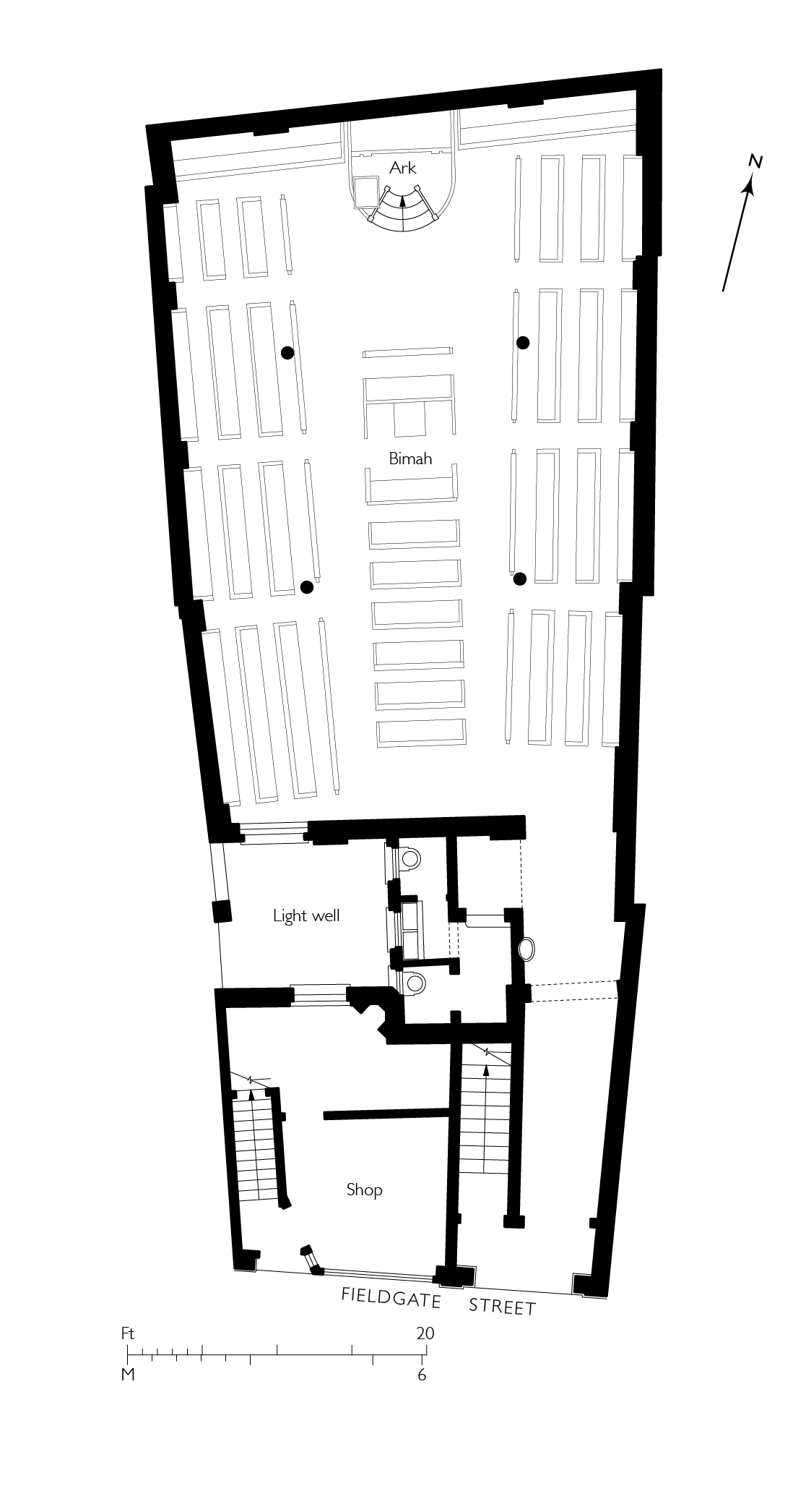
"id": 1699,
"title": "Fieldgate Street Great Synagogue, ground-floor plan as designed in 1898",
"author": {
"id": 82,
"username": "HelenJones"
},
"feature": {
"id": 837,
"type": "Feature",
"geometry": {
"type": "MultiPolygon",
"coordinates": [
[
[
[
-0.065533721939634,
51.51703253016194
],
[
-0.065646714781391,
51.517231659604
],
[
-0.065502188596495,
51.517268409638795
],
[
-0.065426771021086,
51.51704234602821
],
[
-0.065533721939634,
51.51703253016194
]
]
]
]
},
"properties": {
"b_number": "41",
"b_name": "Former Fieldgate Street Great Synagogue",
"street": "Fieldgate Street",
"address": "Former Fieldgate Street Great Synagogue, 41 Fieldgate Street",
"feature_type": "WHITECHAPEL_BUILDING",
"count": 16,
"search_str": "Former Fieldgate Street Great Synagogue"
},
"tags": [
"synagogue"
]
},
"file": "https://surveyoflondon.org/media/uploads/features/837/synagogue%20plan%203.jpg",
"description": "",
"copyright": true,
"created": "2020-05-11"
},
{
"id": 1663,
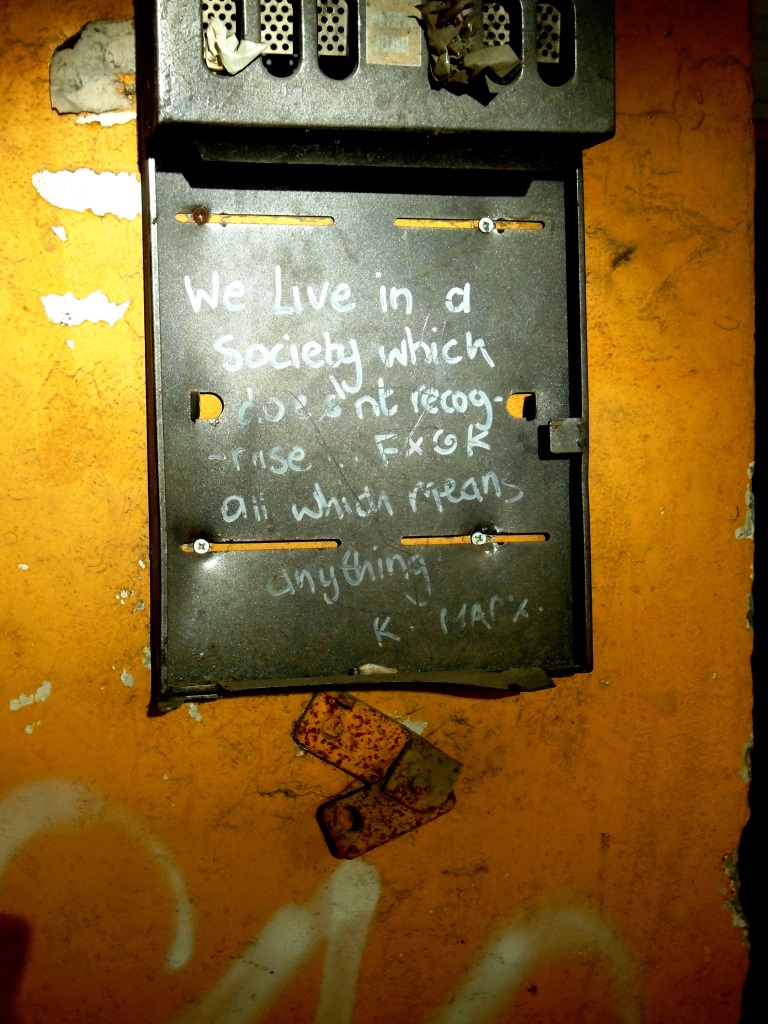
"title": "Inside - dubious quote attributed to \"K. Marx\" graffiti on fitting",
"author": {
"id": 118,
"username": "david2"
},
"feature": {
"id": 350,
"type": "Feature",
"geometry": {
"type": "MultiPolygon",
"coordinates": [
[
[
[
-0.074647451142337,
51.51530527967592
],
[
-0.074357471765638,
51.515414167283886
],
[
-0.073990659509213,
51.51505709668585
],
[
-0.074395588069206,
51.514895160577964
],
[
-0.074663489419344,
51.51509835683479
],
[
-0.074491595155131,
51.515179363370244
],
[
-0.074647451142337,
51.51530527967592
]
]
]
]
},
"properties": {
"b_number": "2-14",
"b_name": "United Standard House",
"street": "Middlesex Street",
"address": "2 to 14 Middlesex Street",
"feature_type": "WHITECHAPEL_BUILDING",
"count": 16,
"search_str": "United Standard House"
},
"tags": []
},
"file": "https://surveyoflondon.org/media/uploads/features/350/DSC00262.JPG",
"description": "During a very short visit to the site - while demolition was taking place - I took this photo. It was in an area preserved longer than others",
"copyright": false,
"created": "2019-09-07"
},
{
"id": 1489,
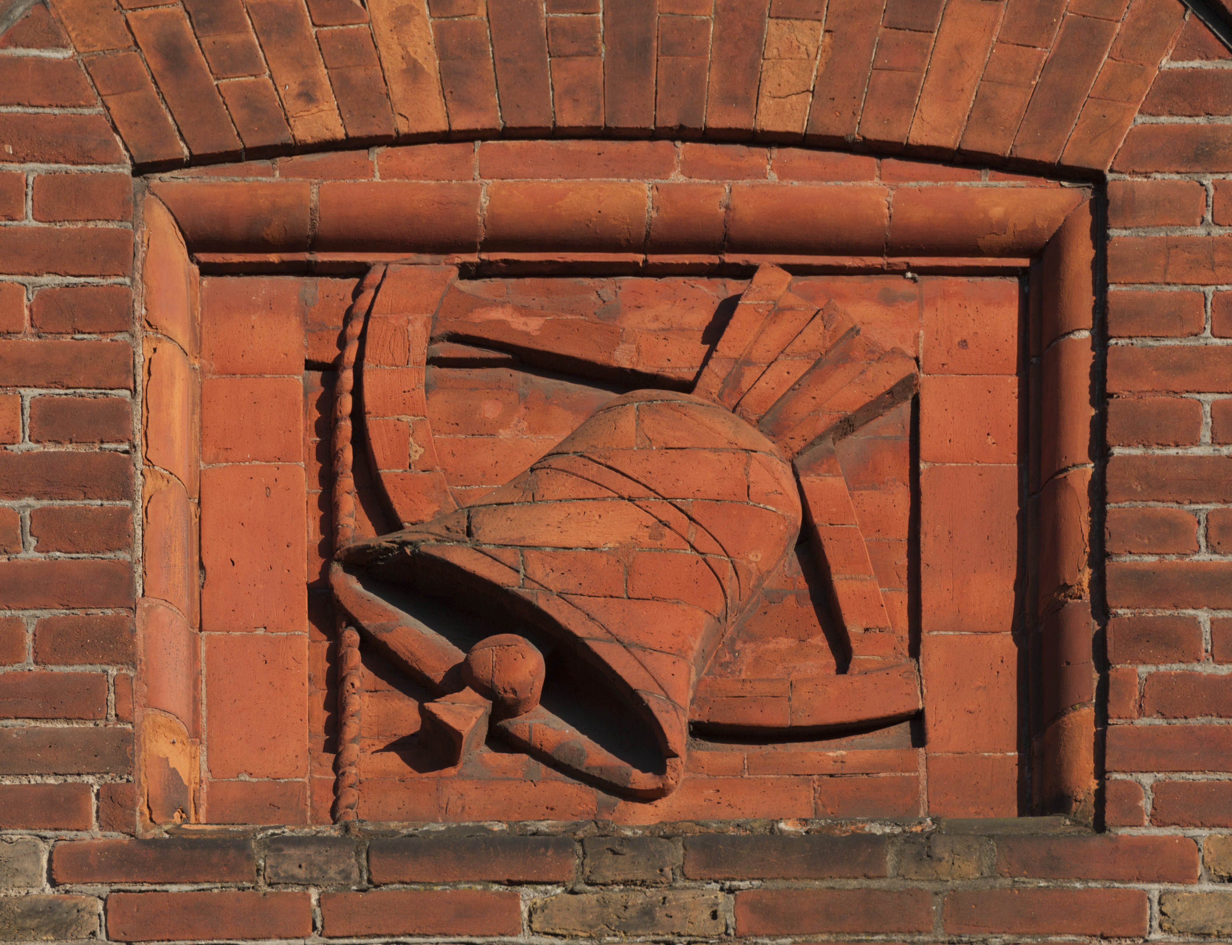
"title": "The Bell, north gable",
"author": {
"id": 27,
"username": "DerekKendall"
},
"feature": {
"id": 342,
"type": "Feature",
"geometry": {
"type": "MultiPolygon",
"coordinates": [
[
[
[
-0.075490206071596,
51.515861855458034
],
[
-0.075659057703334,
51.515761260447185
],
[
-0.075659062914062,
51.515761259453065
],
[
-0.075749282153509,
51.51581828564512
],
[
-0.075749034035063,
51.515842125205815
],
[
-0.075527961139716,
51.51590355994891
],
[
-0.075479038495002,
51.5158713869675
],
[
-0.075490214155051,
51.515861860567476
],
[
-0.075490206071596,
51.515861855458034
]
]
]
]
},
"properties": {
"b_number": "50",
"b_name": "The Bell, 50 Middlesex Street",
"street": "Middlesex Street",
"address": "The Bell, 50 Middlesex Street",
"feature_type": "WHITECHAPEL_BUILDING",
"count": 10,
"search_str": "The Bell, 50 Middlesex Street"
},
"tags": [
"house",
"public"
]
},
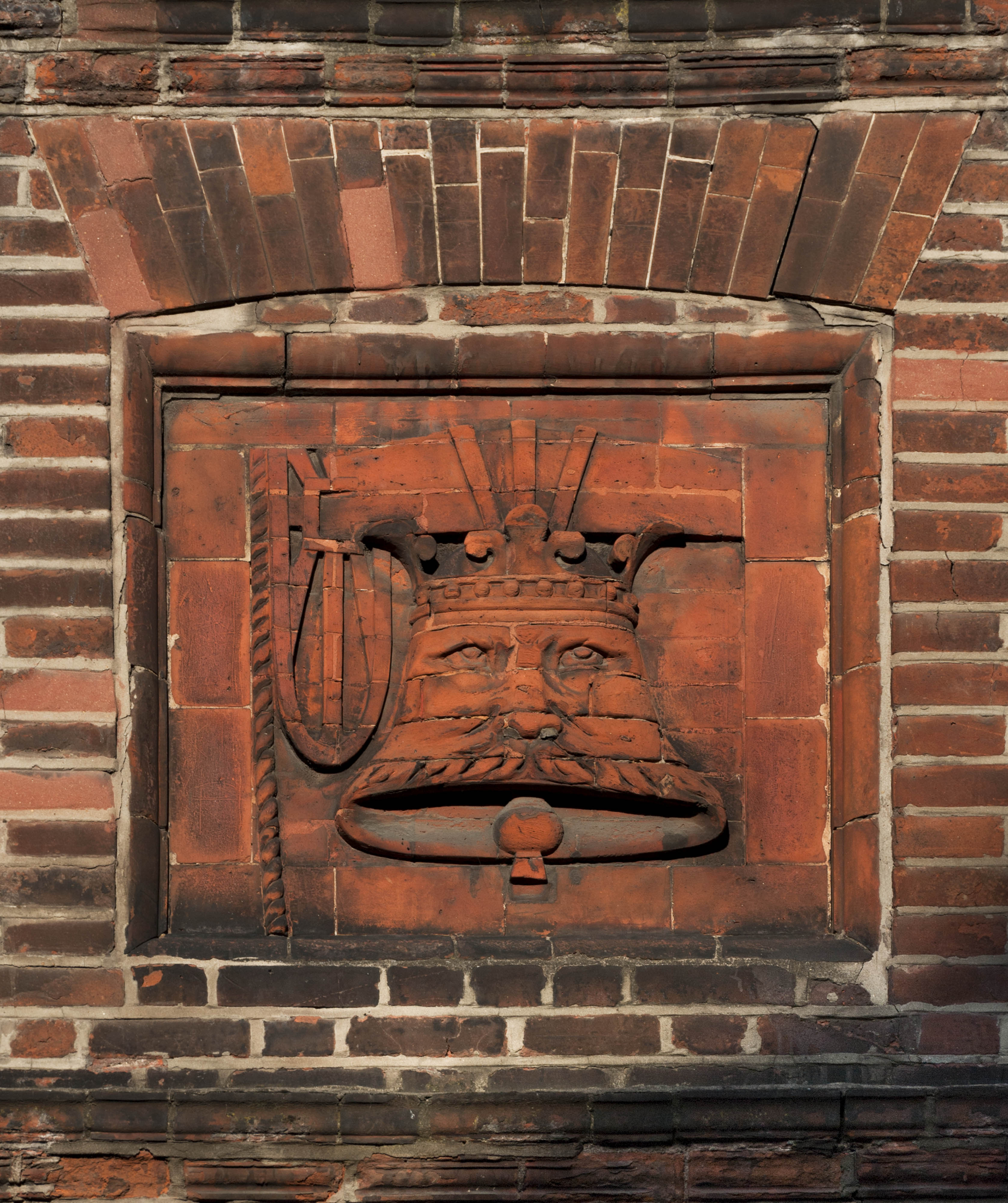
"file": "https://surveyoflondon.org/media/uploads/features/342/SoL%20Whitechapel%20100919.jpg",
"description": "Rubbed brick panel depicting a bell from the gable of The Bell on New Goulston Street, June 2017",
"copyright": true,
"created": "2019-01-07"
},
{
"id": 1486,
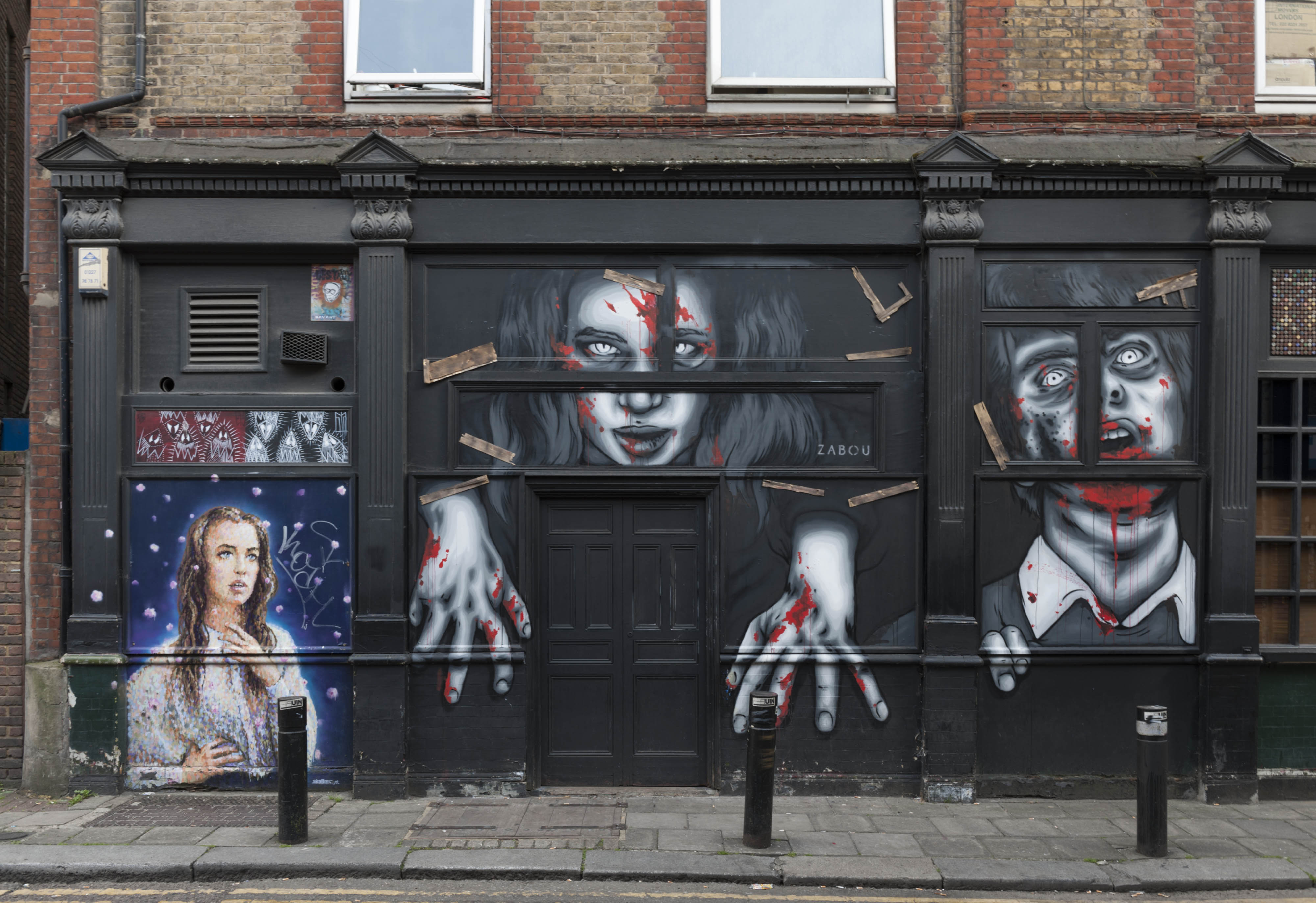
"title": "The Bell and Zabou",
"author": {
"id": 27,
"username": "DerekKendall"
},
"feature": {
"id": 342,
"type": "Feature",
"geometry": {
"type": "MultiPolygon",
"coordinates": [
[
[
[
-0.075490206071596,
51.515861855458034
],
[
-0.075659057703334,
51.515761260447185
],
[
-0.075659062914062,
51.515761259453065
],
[
-0.075749282153509,
51.51581828564512
],
[
-0.075749034035063,
51.515842125205815
],
[
-0.075527961139716,
51.51590355994891
],
[
-0.075479038495002,
51.5158713869675
],
[
-0.075490214155051,
51.515861860567476
],
[
-0.075490206071596,
51.515861855458034
]
]
]
]
},
"properties": {
"b_number": "50",
"b_name": "The Bell, 50 Middlesex Street",
"street": "Middlesex Street",
"address": "The Bell, 50 Middlesex Street",
"feature_type": "WHITECHAPEL_BUILDING",
"count": 10,
"search_str": "The Bell, 50 Middlesex Street"
},
"tags": [
"house",
"public"
]
},
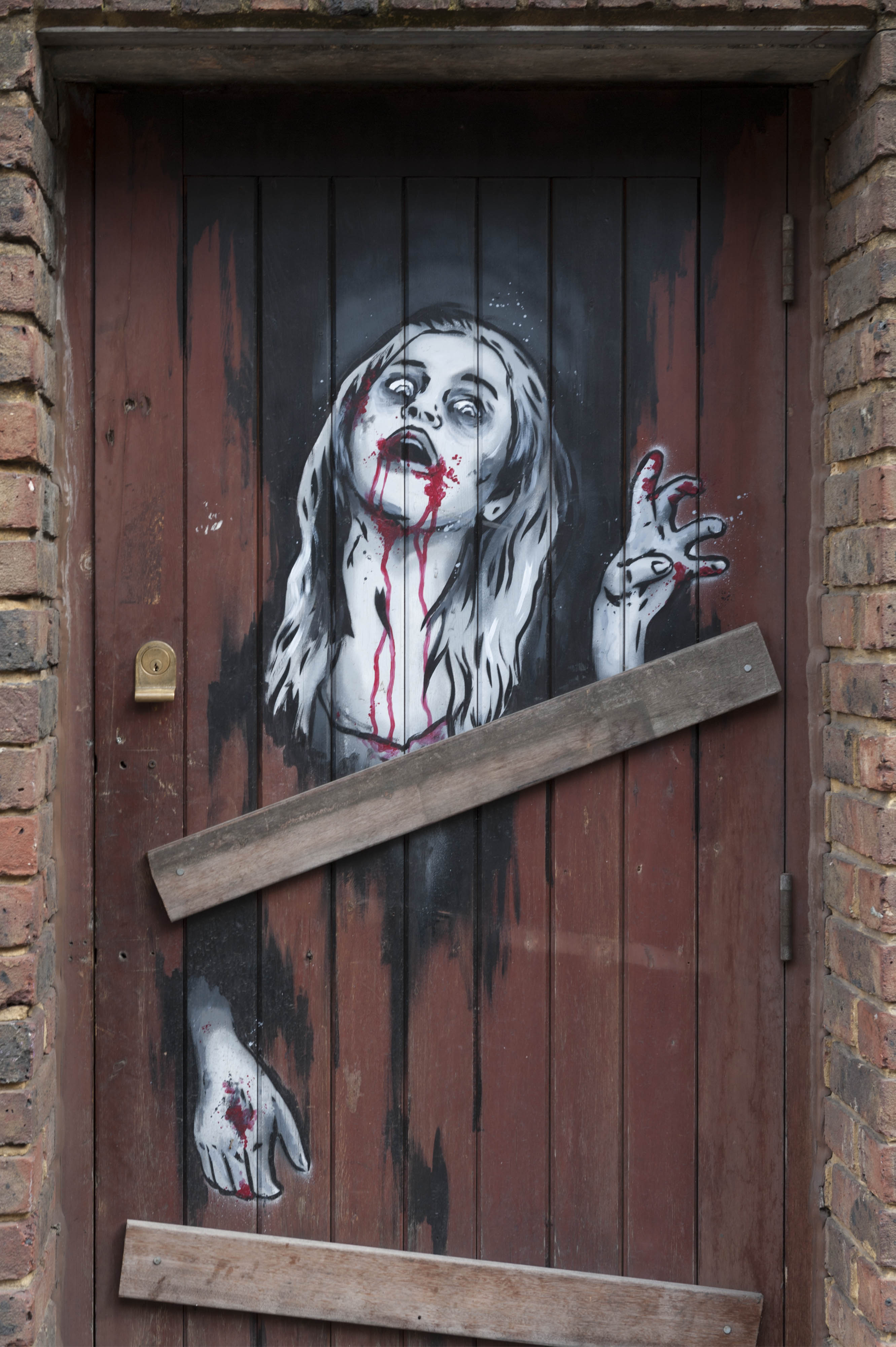
"file": "https://surveyoflondon.org/media/uploads/features/342/SoL%20Whitechapel%20100910.jpg",
"description": "The New Goulston Street frontage of the Bell, June 2017, showing a Hallowe'en painting by French street artist Zabou, who regularly paints on The Bell. It has been repainted several times since by Zabou, themes including Alice in Wonderland (Oct 2017) and the film The Shining (Dec 2018). The portrait of the woman at the left is The Belle by JimmyC from 2014, which remains.",
"copyright": true,
"created": "2019-01-07"
},
{
"id": 1487,
"title": "The Bell and Zabou",
"author": {
"id": 27,
"username": "DerekKendall"
},
"feature": {
"id": 342,
"type": "Feature",
"geometry": {
"type": "MultiPolygon",
"coordinates": [
[
[
[
-0.075490206071596,
51.515861855458034
],
[
-0.075659057703334,
51.515761260447185
],
[
-0.075659062914062,
51.515761259453065
],
[
-0.075749282153509,
51.51581828564512
],
[
-0.075749034035063,
51.515842125205815
],
[
-0.075527961139716,
51.51590355994891
],
[
-0.075479038495002,
51.5158713869675
],
[
-0.075490214155051,
51.515861860567476
],
[
-0.075490206071596,
51.515861855458034
]
]
]
]
},
"properties": {
"b_number": "50",
"b_name": "The Bell, 50 Middlesex Street",
"street": "Middlesex Street",
"address": "The Bell, 50 Middlesex Street",
"feature_type": "WHITECHAPEL_BUILDING",
"count": 10,
"search_str": "The Bell, 50 Middlesex Street"
},
"tags": [
"house",
"public"
]
},
"file": "https://surveyoflondon.org/media/uploads/features/342/SoL%20Whitechapel%20100912.jpg",
"description": "Detail of the door to the rear yard of the Bell, June 2017, showing Jack the Ripper-themed painting by French street artist Zabou, who regularly paints on The Bell.",
"copyright": true,
"created": "2019-01-07"
},
{
"id": 1712,
"title": "St Paul's Church, Dock Street, 1980",
"author": {
"id": 153,
"username": "danny"
},
"feature": {
"id": 1371,
"type": "Feature",
"geometry": {
"type": "MultiPolygon",
"coordinates": [
[
[
[
-0.068057208494737,
51.50994707934026
],
[
-0.068128144074089,
51.510098245489516
],
[
-0.067833383002716,
51.510150364911766
],
[
-0.0678086195768,
51.51009705078618
],
[
-0.067791713048129,
51.51010026052854
],
[
-0.067768418439094,
51.51005627276704
],
[
-0.06778532495294,
51.510053063027875
],
[
-0.06776230081429,
51.510002684478415
],
[
-0.068057208494737,
51.50994707934026
]
]
]
]
},
"properties": {
"b_number": "",
"b_name": "St Paul's Church",
"street": "Dock Street",
"address": "Former Church of St Paul, Dock Street",
"feature_type": "WHITECHAPEL_BUILDING",
"count": 16,
"search_str": "St Paul's Church"
},
"tags": [
"Capt. Robert J. Elliot",
"Henry Roberts",
"James Pennethorne",
"Rev. Dan Greatorex",
"Rev. Joseph Williamson",
"William Cubitt"
]
},
"file": "https://surveyoflondon.org/media/uploads/features/1371/St%20Paul's%20Dock%20Street%201980.jpg",
"description": "An image of St Paul's Church, Dock Street showing other neighbouring buildings including those on either side of the junction with Flank Street. The weathervane - a ship is still visible on the spire. I understand this was removed to St Paul's School in Wellclose Square some years after this picture was taken.",
"copyright": false,
"created": "2020-05-13"
},
{
"id": 1714,
"title": "Fire! 11 June 2019 at 133 Leman Street",
"author": {
"id": 153,
"username": "danny"
},
"feature": {
"id": 1265,
"type": "Feature",
"geometry": {
"type": "MultiPolygon",
"coordinates": [
[
[
[
-0.068555349773438,
51.51155816055727
],
[
-0.068695050759725,
51.51151170331988
],
[
-0.068725524709279,
51.511549485442806
],
[
-0.06858193220328,
51.51159216882458
],
[
-0.068555349773438,
51.51155816055727
]
]
]
]
},
"properties": {
"b_number": "133",
"b_name": "",
"street": "Leman Street",
"address": "133 Leman Street",
"feature_type": "WHITECHAPEL_BUILDING",
"count": 5,
"search_str": "133 Leman Street"
},
"tags": []
},
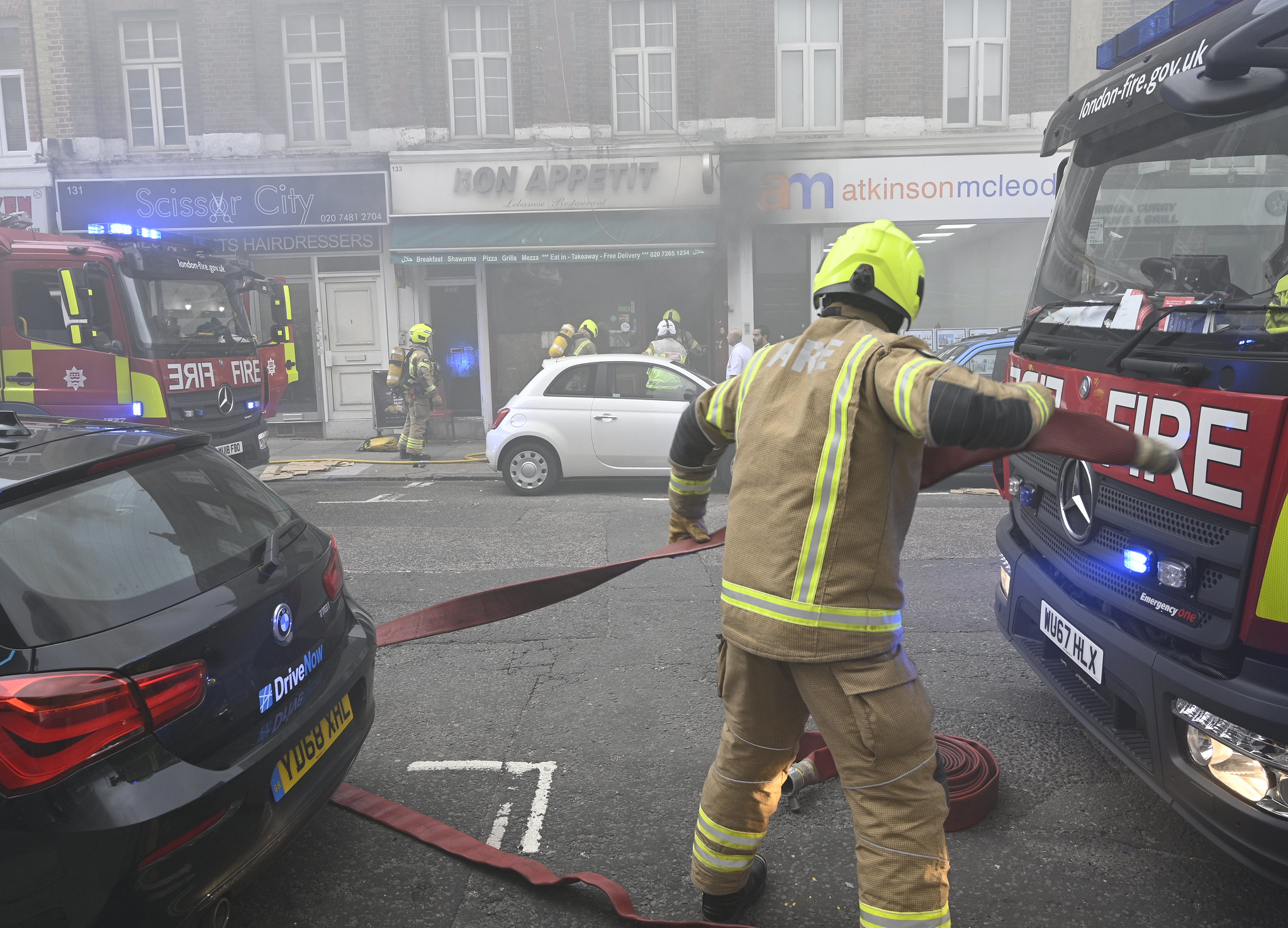
"file": "https://surveyoflondon.org/media/uploads/features/1265/Fire%20133%20Leman%20Street%2011%20June%202019.jpg",
"description": "Firemen attend a blaze in the kitchen which wrecked the Bon Appetit cafe / restaurant at 133 Leman Street on 11 June 2019.",
"copyright": false,
"created": "2020-05-13"
},
{
"id": 1757,
"title": "Calcutta House from the east in 2017",
"author": {
"id": 27,
"username": "DerekKendall"
},
"feature": {
"id": 405,
"type": "Feature",
"geometry": {
"type": "MultiPolygon",
"coordinates": [
[
[
[
-0.073978291920849,
51.515581075868006
],
[
-0.073620345272929,
51.51568885255038
],
[
-0.073380955638186,
51.515461353381355
],
[
-0.073631737839895,
51.51536118144104
],
[
-0.073631738965982,
51.51536117507143
],
[
-0.073631749071862,
51.51536118467535
],
[
-0.073777296847877,
51.515301562785204
],
[
-0.073777291005618,
51.51530155723316
],
[
-0.073950564821505,
51.515227043910336
],
[
-0.074095345892289,
51.51536355445505
],
[
-0.073989551977284,
51.51540723415056
],
[
-0.074055615752804,
51.5154824072535
],
[
-0.074101425140715,
51.515466735247216
],
[
-0.07414978302715,
51.51552176080992
],
[
-0.07414978140901,
51.515521768515015
],
[
-0.074054115992124,
51.515554308575716
],
[
-0.074054080597776,
51.51555514765241
],
[
-0.073978291920849,
51.515581075868006
]
]
]
]
},
"properties": {
"b_number": "",
"b_name": "Calcutta House",
"street": "Goulston Street",
"address": "Calcutta House, London Metropolitan University, Goulston Street",
"feature_type": "WHITECHAPEL_BUILDING",
"count": 6,
"search_str": "Calcutta House"
},
"tags": []
},
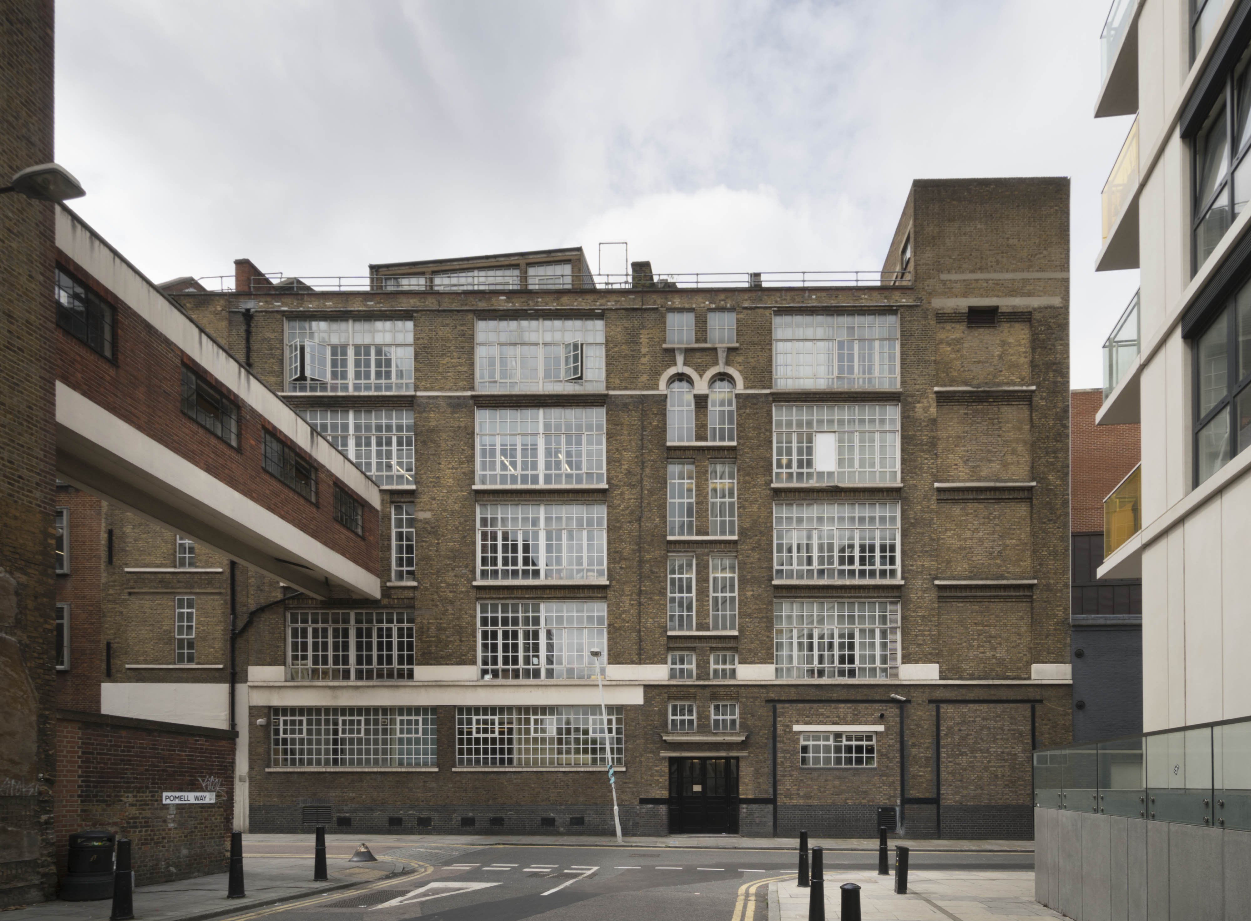
"file": "https://surveyoflondon.org/media/uploads/features/405/SoL%20Whitechapel%20100943.jpg",
"description": "",
"copyright": true,
"created": "2020-08-04"
},
{
"id": 1706,
"title": "Camperdown Street c 1980",
"author": {
"id": 153,
"username": "danny"
},
"feature": {
"id": 1437,
"type": "Feature",
"geometry": {
"type": "MultiPolygon",
"coordinates": [
[
[
[
-0.070977656579359,
51.514031042914745
],
[
-0.07097765657936,
51.514031042914745
],
[
-0.071113759773247,
51.513989212236595
],
[
-0.071172652065743,
51.51406153908406
],
[
-0.071199507836854,
51.514049282744814
],
[
-0.071265551856606,
51.51411621969721
],
[
-0.071077762376349,
51.51418738833704
],
[
-0.070964094607832,
51.51406576686303
],
[
-0.070990631361078,
51.51404698663987
],
[
-0.070977656579359,
51.514031042914745
]
]
]
]
},
"properties": {
"b_number": "28",
"b_name": "",
"street": "Leman Street",
"address": "Pennine House, 28 Leman Street",
"feature_type": "WHITECHAPEL_BUILDING",
"count": 3,
"search_str": "Pennine House, 28 Leman Street"
},
"tags": []
},
"file": "https://surveyoflondon.org/media/uploads/features/1437/Camperdown%20Street.jpg",
"description": "Circa 1980 image looking south down Leman Street towards the junction with Camperdown Street. CWS HQ at 99 Leman Street visible in background. Former Braham Street runs across the foreground of the picture.",
"copyright": false,
"created": "2020-05-12"
},
{
"id": 1826,
"title": "Magdalen Row, 17–21 Prescot Street, front elevation as built in 1778–81 (drawing by Helen Jones)",
"author": {
"id": 2,
"username": "surveyoflondon"
},
"feature": {
"id": 1293,
"type": "Feature",
"geometry": {
"type": "MultiPolygon",
"coordinates": [
[
[
[
-0.071513981451963,
51.511415502887715
],
[
-0.071477167616823,
51.511328407652236
],
[
-0.071532965125774,
51.51132107663319
],
[
-0.071527913476098,
51.51130754303777
],
[
-0.071561851787731,
51.51130283790823
],
[
-0.07160179754467,
51.51139998766625
],
[
-0.071513981451963,
51.511415502887715
]
]
]
]
},
"properties": {
"b_number": "23",
"b_name": "",
"street": "Prescot Street",
"address": "23 Prescot Street",
"feature_type": "WHITECHAPEL_BUILDING",
"count": 3,
"search_str": "23 Prescot Street"
},
"tags": []
},
"file": "https://surveyoflondon.org/media/uploads/features/1293/Prescott%20Street%20Elevation%20combined%20A4%201.jpg",
"description": "",
"copyright": true,
"created": "2021-04-30"
},
{
"id": 1818,
"title": "4 Gunthorpe Street in 2021",
"author": {
"id": 27,
"username": "DerekKendall"
},
"feature": {
"id": 325,
"type": "Feature",
"geometry": {
"type": "MultiPolygon",
"coordinates": [
[
[
[
-0.071035600438155,
51.51592979119321
],
[
-0.071142450636413,
51.51589420328739
],
[
-0.071184946068849,
51.51594387095533
],
[
-0.071219199873383,
51.51593246222619
],
[
-0.071310449605109,
51.51603911227375
],
[
-0.071180693712412,
51.51608232930652
],
[
-0.071160737718236,
51.51605900528738
],
[
-0.071147553509545,
51.516063396461014
],
[
-0.071035600438155,
51.51592979119321
]
]
]
]
},
"properties": {
"b_number": "4",
"b_name": "4 Gunthorpe Street",
"street": "Gunthorpe Street",
"address": "4 Gunthorpe Street, London E1 7RQ",
"feature_type": "WHITECHAPEL_BUILDING",
"count": 3,
"search_str": "4 Gunthorpe Street"
},
"tags": []
},
"file": "https://surveyoflondon.org/media/uploads/features/325/SoL%20Whitechapel%20102897.jpg",
"description": "",
"copyright": true,
"created": "2021-03-30"
},
{
"id": 1488,
"title": "Bell with face from The Bell",
"author": {
"id": 27,
"username": "DerekKendall"
},
"feature": {
"id": 342,
"type": "Feature",
"geometry": {
"type": "MultiPolygon",
"coordinates": [
[
[
[
-0.075490206071596,
51.515861855458034
],
[
-0.075659057703334,
51.515761260447185
],
[
-0.075659062914062,
51.515761259453065
],
[
-0.075749282153509,
51.51581828564512
],
[
-0.075749034035063,
51.515842125205815
],
[
-0.075527961139716,
51.51590355994891
],
[
-0.075479038495002,
51.5158713869675
],
[
-0.075490214155051,
51.515861860567476
],
[
-0.075490206071596,
51.515861855458034
]
]
]
]
},
"properties": {
"b_number": "50",
"b_name": "The Bell, 50 Middlesex Street",
"street": "Middlesex Street",
"address": "The Bell, 50 Middlesex Street",
"feature_type": "WHITECHAPEL_BUILDING",
"count": 10,
"search_str": "The Bell, 50 Middlesex Street"
},
"tags": [
"house",
"public"
]
},
"file": "https://surveyoflondon.org/media/uploads/features/342/SoL%20Whitechapel%20100915.jpg",
"description": "Rubbed brick panel of a bell with a face on the canted corner pediment of The Bell, June 2017",
"copyright": true,
"created": "2019-01-07"
},
{
"id": 1722,
"title": "Gunmakers' Company proof house complex from the north-east in 2017",
"author": {
"id": 27,
"username": "DerekKendall"
},
"feature": {
"id": 1016,
"type": "Feature",
"geometry": {
"type": "MultiPolygon",
"coordinates": [
[
[
[
-0.068260232398246,
51.51477078323367
],
[
-0.068015891167626,
51.5147824074063
],
[
-0.067989584029828,
51.514607222723676
],
[
-0.068165517221812,
51.5145962554253
],
[
-0.068167507270317,
51.51461124694583
],
[
-0.068237397616931,
51.5146070496752
],
[
-0.068260232398246,
51.51477078323367
]
],
[
[
-0.068202841801552,
51.51466683191732
],
[
-0.068136591673853,
51.51467046256953
],
[
-0.068144363769439,
51.51473136877517
],
[
-0.068208694296891,
51.51472806567735
],
[
-0.068202841801552,
51.51466683191732
]
],
[
[
-0.068088690886023,
51.514711682651345
],
[
-0.06808732190461,
51.51470153629181
],
[
-0.068009718204265,
51.51470567288329
],
[
-0.068011037313001,
51.51471548132591
],
[
-0.068088690886023,
51.514711682651345
]
]
]
]
},
"properties": {
"b_number": "48",
"b_name": "The Proof House, 48-50 Commercial Road",
"street": "Commercial Road",
"address": "Worshipful Company of Gunmakers, The Proof House, 48-50 Commercial Road",
"feature_type": "WHITECHAPEL_BUILDING",
"count": 15,
"search_str": "The Proof House, 48-50 Commercial Road"
},
"tags": []
},
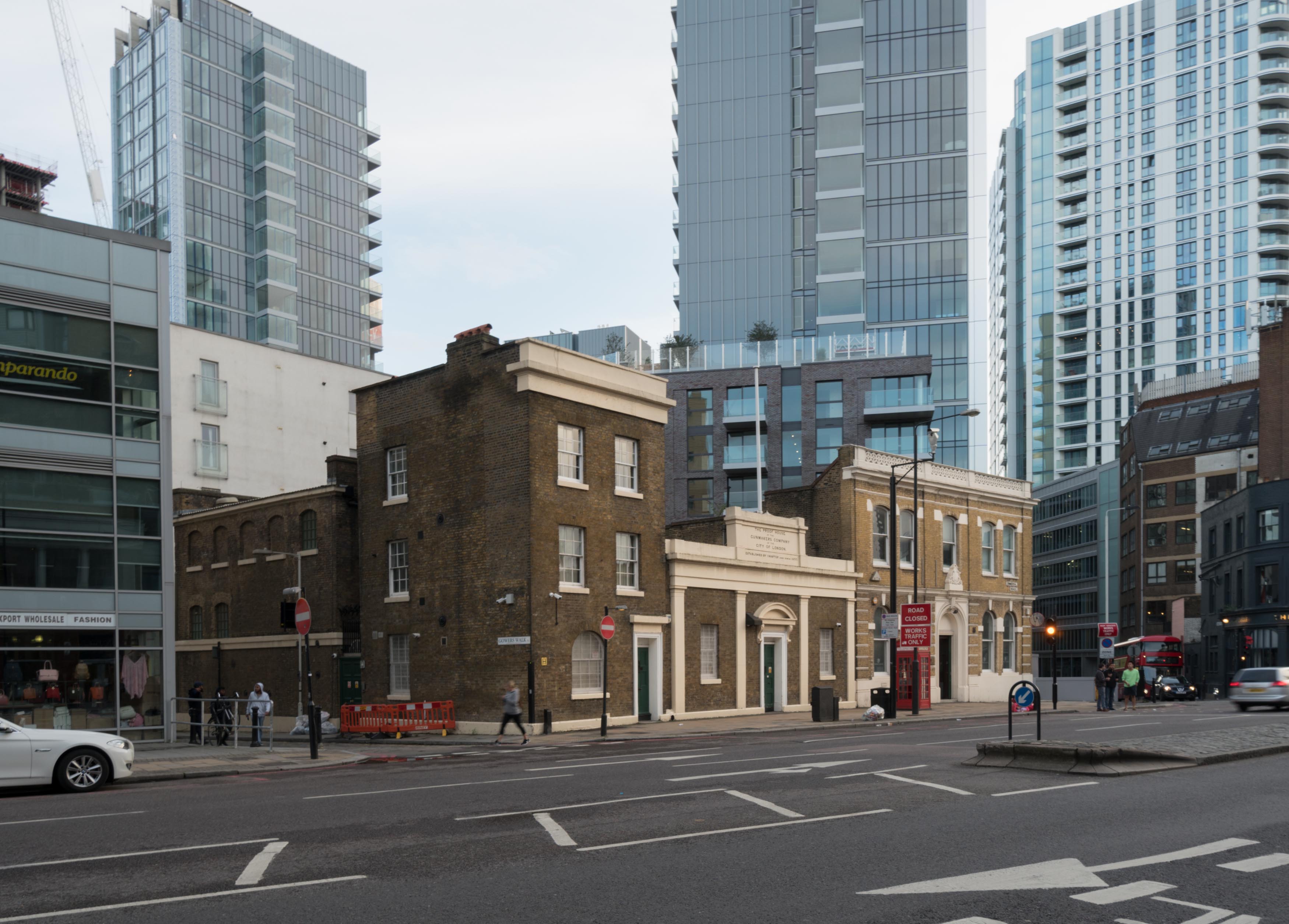
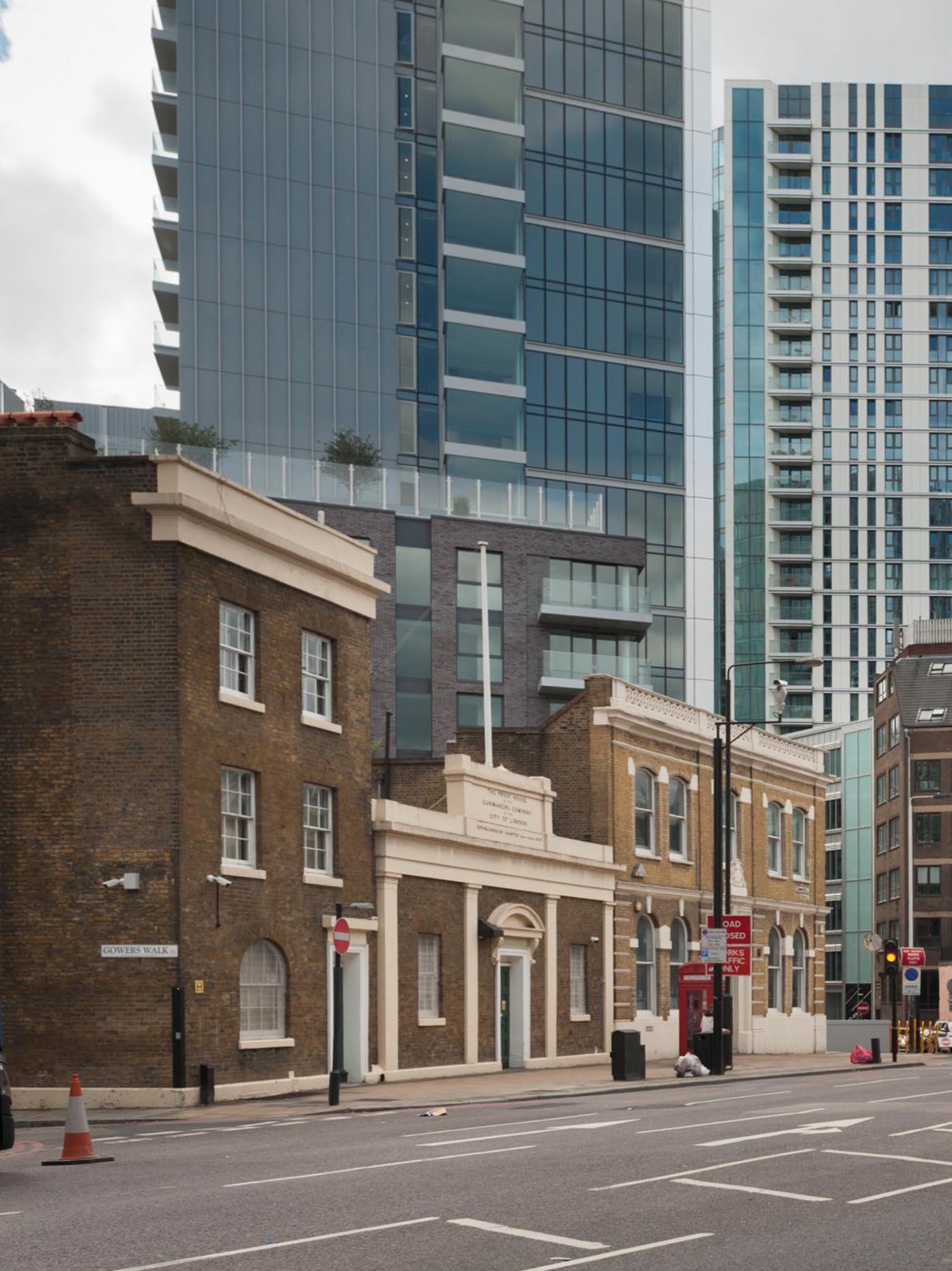
"file": "https://surveyoflondon.org/media/uploads/features/1016/SoL%20Whitechapel%20101278.jpg",
"description": "",
"copyright": true,
"created": "2020-06-01"
},
{
"id": 1723,
"title": "Gunmakers' Company proof house complex from the north-east in 2017",
"author": {
"id": 27,
"username": "DerekKendall"
},
"feature": {
"id": 1016,
"type": "Feature",
"geometry": {
"type": "MultiPolygon",
"coordinates": [
[
[
[
-0.068260232398246,
51.51477078323367
],
[
-0.068015891167626,
51.5147824074063
],
[
-0.067989584029828,
51.514607222723676
],
[
-0.068165517221812,
51.5145962554253
],
[
-0.068167507270317,
51.51461124694583
],
[
-0.068237397616931,
51.5146070496752
],
[
-0.068260232398246,
51.51477078323367
]
],
[
[
-0.068202841801552,
51.51466683191732
],
[
-0.068136591673853,
51.51467046256953
],
[
-0.068144363769439,
51.51473136877517
],
[
-0.068208694296891,
51.51472806567735
],
[
-0.068202841801552,
51.51466683191732
]
],
[
[
-0.068088690886023,
51.514711682651345
],
[
-0.06808732190461,
51.51470153629181
],
[
-0.068009718204265,
51.51470567288329
],
[
-0.068011037313001,
51.51471548132591
],
[
-0.068088690886023,
51.514711682651345
]
]
]
]
},
"properties": {
"b_number": "48",
"b_name": "The Proof House, 48-50 Commercial Road",
"street": "Commercial Road",
"address": "Worshipful Company of Gunmakers, The Proof House, 48-50 Commercial Road",
"feature_type": "WHITECHAPEL_BUILDING",
"count": 15,
"search_str": "The Proof House, 48-50 Commercial Road"
},
"tags": []
},
"file": "https://surveyoflondon.org/media/uploads/features/1016/SoL%20Whitechapel%20101255.jpg",
"description": "",
"copyright": true,
"created": "2020-06-01"
},
{
"id": 1739,
"title": "Gunmakers' Company's proof-house, ground-floor plan in 1993, drawing by Helen Jones",
"author": {
"id": 2,
"username": "surveyoflondon"
},
"feature": {
"id": 1016,
"type": "Feature",
"geometry": {
"type": "MultiPolygon",
"coordinates": [
[
[
[
-0.068260232398246,
51.51477078323367
],
[
-0.068015891167626,
51.5147824074063
],
[
-0.067989584029828,
51.514607222723676
],
[
-0.068165517221812,
51.5145962554253
],
[
-0.068167507270317,
51.51461124694583
],
[
-0.068237397616931,
51.5146070496752
],
[
-0.068260232398246,
51.51477078323367
]
],
[
[
-0.068202841801552,
51.51466683191732
],
[
-0.068136591673853,
51.51467046256953
],
[
-0.068144363769439,
51.51473136877517
],
[
-0.068208694296891,
51.51472806567735
],
[
-0.068202841801552,
51.51466683191732
]
],
[
[
-0.068088690886023,
51.514711682651345
],
[
-0.06808732190461,
51.51470153629181
],
[
-0.068009718204265,
51.51470567288329
],
[
-0.068011037313001,
51.51471548132591
],
[
-0.068088690886023,
51.514711682651345
]
]
]
]
},
"properties": {
"b_number": "48",
"b_name": "The Proof House, 48-50 Commercial Road",
"street": "Commercial Road",
"address": "Worshipful Company of Gunmakers, The Proof House, 48-50 Commercial Road",
"feature_type": "WHITECHAPEL_BUILDING",
"count": 15,
"search_str": "The Proof House, 48-50 Commercial Road"
},
"tags": []
},
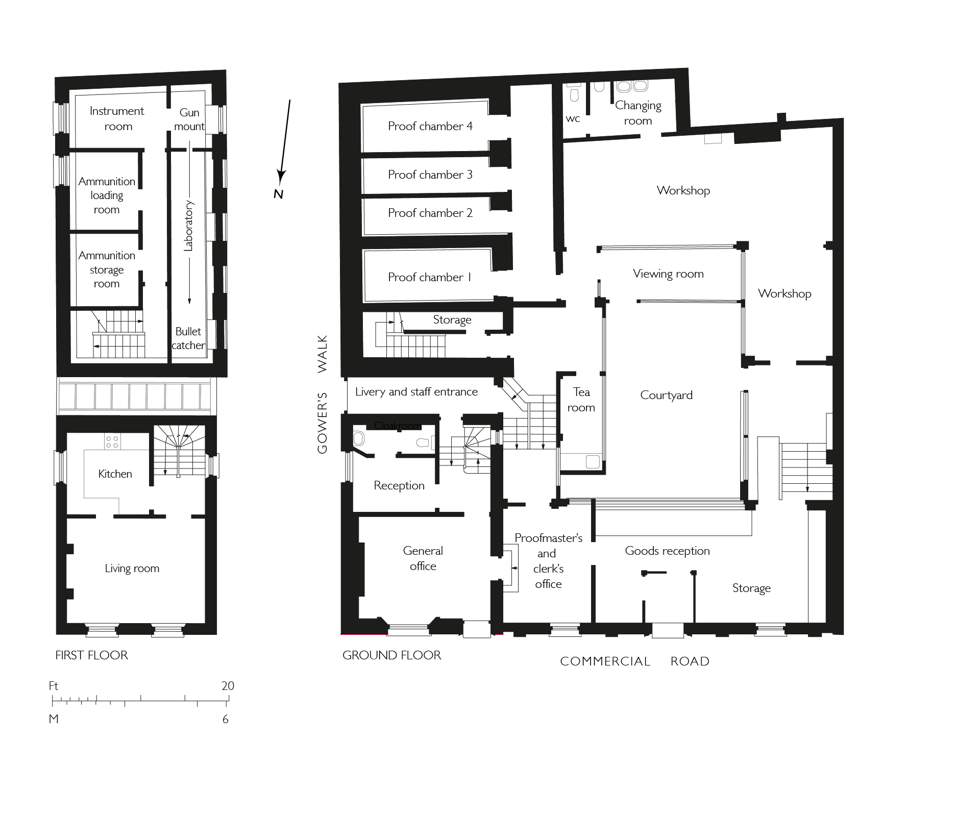
"file": "https://surveyoflondon.org/media/uploads/features/1016/Proof%20House%20plans%203.jpg",
"description": "",
"copyright": true,
"created": "2020-07-30"
},
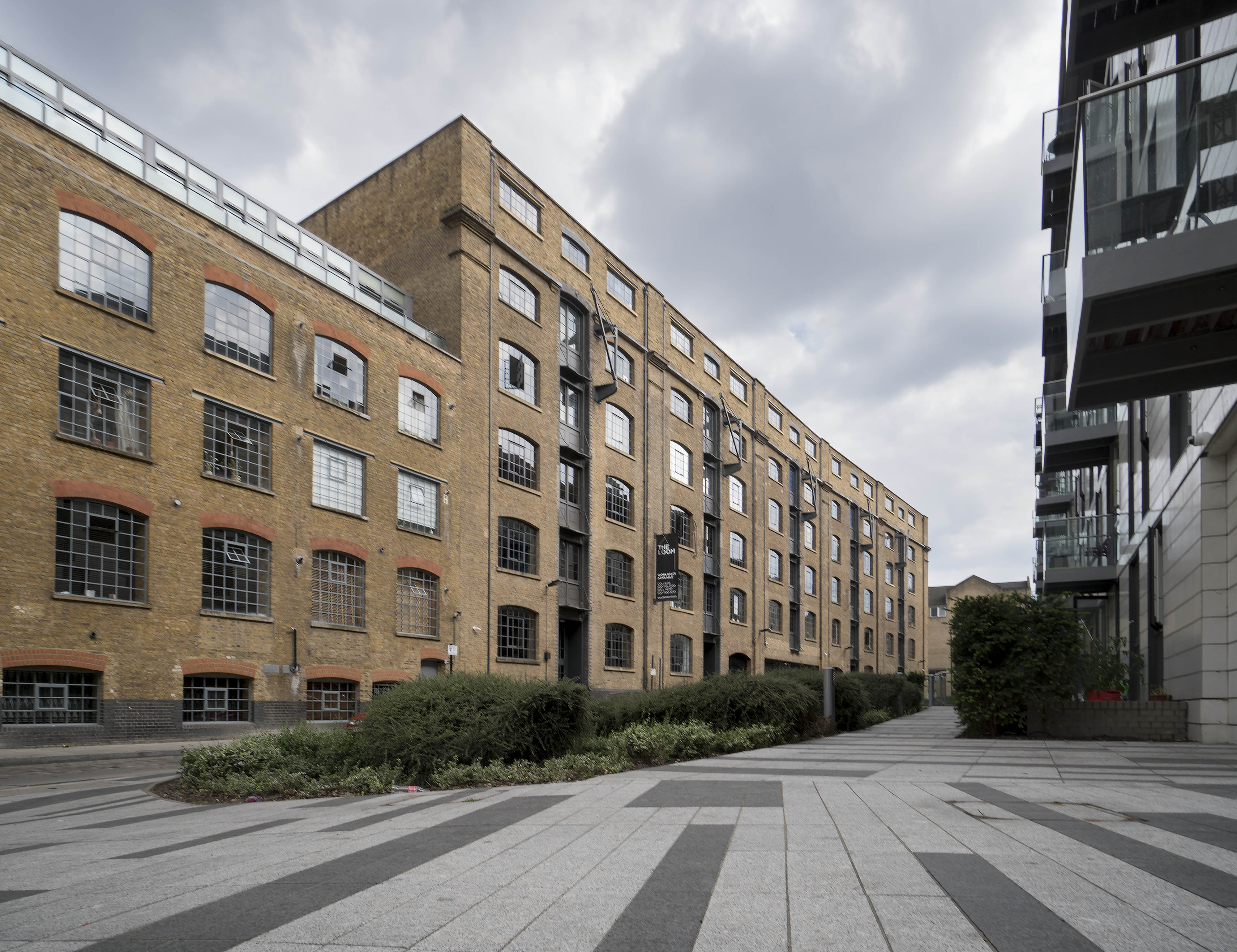
{
"id": 1767,
"title": "The Loom from the north-west in 2017",
"author": {
"id": 27,
"username": "DerekKendall"
},
"feature": {
"id": 1054,
"type": "Feature",
"geometry": {
"type": "MultiPolygon",
"coordinates": [
[
[
[
-0.067624988998484,
51.51289617869746
],
[
-0.067180798939432,
51.512911920220176
],
[
-0.067133711242303,
51.512567481740106
],
[
-0.067109487043094,
51.512455102488246
],
[
-0.067094022808022,
51.51237277531417
],
[
-0.067355415992025,
51.51233326528946
],
[
-0.067556363832002,
51.51229971390102
],
[
-0.067559932926382,
51.512347068603766
],
[
-0.067564604000022,
51.512473731628916
],
[
-0.06762108926581,
51.51287737297797
],
[
-0.067624988998484,
51.51289617869746
]
]
]
]
},
"properties": {
"b_number": "101",
"b_name": "The Loom, 101 Back Church Lane",
"street": "Back Church Lane",
"address": "The Loom, 101 Back Church Lane",
"feature_type": "WHITECHAPEL_BUILDING",
"count": 10,
"search_str": "The Loom, 101 Back Church Lane"
},
"tags": []
},
"file": "https://surveyoflondon.org/media/uploads/features/1054/SoL%20Whitechapel%20101037.jpg",
"description": "",
"copyright": true,
"created": "2020-08-04"
},
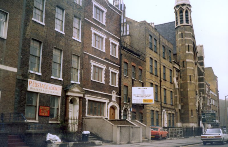
{
"id": 1705,
"title": "24 Prescot Street",
"author": {
"id": 153,
"username": "danny"
},
"feature": {
"id": 1295,
"type": "Feature",
"geometry": {
"type": "MultiPolygon",
"coordinates": [
[
[
[
-0.071706015667423,
51.51096836077219
],
[
-0.071760673580627,
51.511094407858565
],
[
-0.071694522326586,
51.511107355424194
],
[
-0.071723514638995,
51.51117537716788
],
[
-0.071731537079554,
51.51117404707196
],
[
-0.071738018293242,
51.511187019360314
],
[
-0.071730451789257,
51.511188649356484
],
[
-0.07175065859756,
51.51124278370494
],
[
-0.071880742816297,
51.51122503927087
],
[
-0.071935648282288,
51.51134524228436
],
[
-0.07160179754467,
51.51139998766625
],
[
-0.071526476862373,
51.51122506187527
],
[
-0.071516150035805,
51.511225476853056
],
[
-0.071512034959162,
51.511211958658905
],
[
-0.071521499273981,
51.51120977508156
],
[
-0.07149261831904,
51.51113912349431
],
[
-0.071306734256067,
51.51116881548001
],
[
-0.071247789729444,
51.511033340787506
],
[
-0.071706015667423,
51.51096836077219
]
]
]
]
},
"properties": {
"b_number": "24",
"b_name": "",
"street": "Prescot Street",
"address": "Premier Inn, 24 Prescot Street",
"feature_type": "WHITECHAPEL_BUILDING",
"count": 7,
"search_str": "Premier Inn, 24 Prescot Street"
},
"tags": []
},
"file": "https://surveyoflondon.org/media/uploads/features/1295/Prescot%20Convent%202.jpg",
"description": "A wider image of 24 Prescot Street and the former Holy Family Sisters Convent. Also shown is the property east of the convent, occupied by P Eustace and Son Ltd, Builders and Decorators.",
"copyright": false,
"created": "2020-05-12"
},
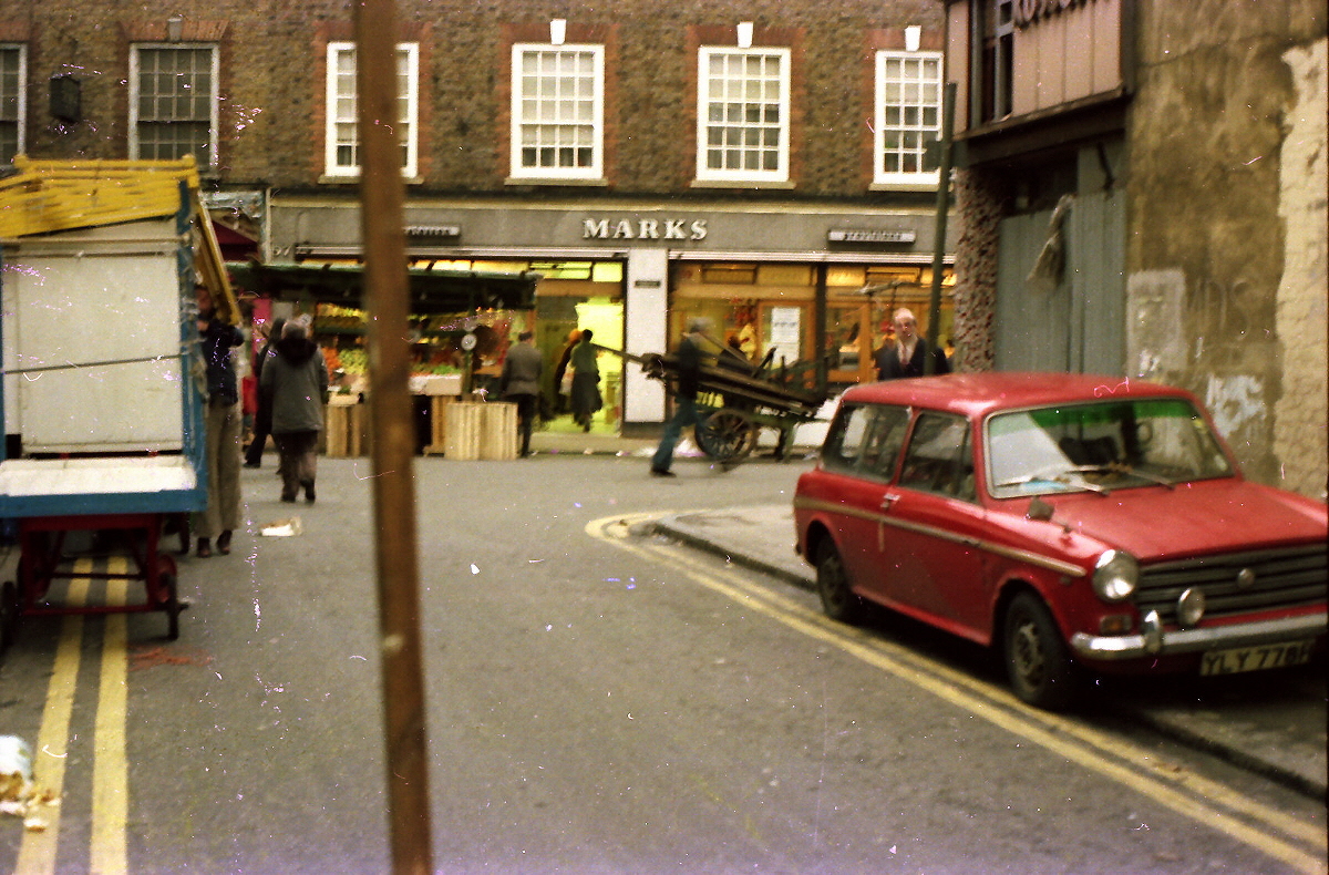
{
"id": 1381,
"title": "View towards Marks of the Lane, Wentworth Street",
"author": {
"id": 252,
"username": "mark3"
},
"feature": {
"id": 1742,
"type": "Feature",
"geometry": {
"type": "MultiPolygon",
"coordinates": [
[
[
[
-0.076387722492951,
51.516257872286374
],
[
-0.07580974439088,
51.51649846859169
],
[
-0.075744693982384,
51.51651411423466
],
[
-0.075332716624042,
51.51665341173461
],
[
-0.075277819023276,
51.516667372076085
],
[
-0.074429584483841,
51.51681699796736
],
[
-0.074402209988697,
51.516763242480046
],
[
-0.075229889371391,
51.51661092868018
],
[
-0.074836715281391,
51.516135055700595
],
[
-0.074917049606191,
51.51611135328064
],
[
-0.075312012611936,
51.51658616747119
],
[
-0.075695505281233,
51.51646463519818
],
[
-0.075779072585588,
51.51644696856364
],
[
-0.076328753388395,
51.516209038390684
],
[
-0.076387722492951,
51.516257872286374
]
]
]
]
},
"properties": {
"b_number": "",
"b_name": "",
"street": "",
"address": "Petticoat Lane Market",
"feature_type": "PLACE",
"count": 39,
"search_str": "Petticoat Lane Market"
},
"tags": []
},
"file": "https://surveyoflondon.org/media/uploads/features/1742/Marks%20deli%201978_0013.jpg",
"description": "A 1975 view taken from Old Castle Street towards a well-loved repository of smoked salmon and shmaltz herrings.",
"copyright": false,
"created": "2018-10-28"
},
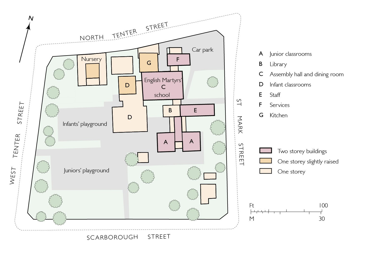
{
"id": 1839,
"title": "English Martyrs RC Primary School, block plan as built in 1970 (drawing by Helen Jones)",
"author": {
"id": 2,
"username": "surveyoflondon"
},
"feature": {
"id": 95,
"type": "Feature",
"geometry": {
"type": "MultiPolygon",
"coordinates": [
[
[
[
-0.072288312836018,
51.512824307605015
],
[
-0.072121612943253,
51.512858159153865
],
[
-0.072025478409202,
51.512890409815434
],
[
-0.072011859946938,
51.51286535896135
],
[
-0.071966433437302,
51.51287497358547
],
[
-0.071934030456307,
51.51281536880901
],
[
-0.071897041880432,
51.51282319750863
],
[
-0.071941565002123,
51.51290509717561
],
[
-0.071831416366548,
51.512942678785066
],
[
-0.071781735212569,
51.5128432447703
],
[
-0.071725521861399,
51.51285417962799
],
[
-0.07176487086724,
51.51293293466522
],
[
-0.071675647300703,
51.51295029074344
],
[
-0.071664919501195,
51.51292881954059
],
[
-0.071609406497337,
51.512939618081724
],
[
-0.071587377736956,
51.512895528347
],
[
-0.071612025842334,
51.512890733734274
],
[
-0.071602267132423,
51.512871202037054
],
[
-0.071638516898164,
51.51286415062836
],
[
-0.071631665323334,
51.51285043746628
],
[
-0.071520551906845,
51.51287205152489
],
[
-0.071479483670422,
51.51278985445861
],
[
-0.071510654926827,
51.51278379096125
],
[
-0.071493990169301,
51.51275043681792
],
[
-0.071398637684366,
51.51276898494904
],
[
-0.071377550943573,
51.51272678005531
],
[
-0.071560243982688,
51.512691242207104
],
[
-0.071533397485951,
51.51263750953841
],
[
-0.071453105482364,
51.51265312815549
],
[
-0.071420349396566,
51.51258756716799
],
[
-0.07167247628417,
51.51253852254618
],
[
-0.071707184439989,
51.512607989805105
],
[
-0.071606228537011,
51.51262762818665
],
[
-0.071633225247965,
51.51268166132723
],
[
-0.07169132093397,
51.512670360313905
],
[
-0.071712967532689,
51.512713685153294
],
[
-0.071811121682106,
51.5126945917228
],
[
-0.071768019434541,
51.512608324512954
],
[
-0.071970981647633,
51.512568842989026
],
[
-0.072017837645733,
51.51266262230734
],
[
-0.071954707384708,
51.51267490286048
],
[
-0.072013765441807,
51.5127931035959
],
[
-0.072057545202814,
51.51278458724506
],
[
-0.072087040272971,
51.512843619299026
],
[
-0.072110299177035,
51.51283569768739
],
[
-0.072067753844785,
51.51274483657161
],
[
-0.072241827775471,
51.51271310224785
],
[
-0.072288312836018,
51.512824307605015
]
]
]
]
},
"properties": {
"b_number": "",
"b_name": "",
"street": "St Mark Street",
"address": "English Martyrs RC Primary School, St Mark Street",
"feature_type": "WHITECHAPEL_BUILDING",
"count": 9,
"search_str": "English Martyrs RC Primary School, St Mark Street"
},
"tags": []
},
"file": "https://surveyoflondon.org/media/uploads/features/95/36.11%20English%20Martyrs%20School.jpg",
"description": "",
"copyright": true,
"created": "2021-05-04"
},
{
"id": 1844,
"title": "Proposal for a new church, c.1712, redrawn from Lambeth Palace Library MS 2750/68",
"author": {
"id": 2,
"username": "surveyoflondon"
},
"feature": {
"id": 1699,
"type": "Feature",
"geometry": {
"type": "MultiPolygon",
"coordinates": [
[
[
[
-0.072807065482267,
51.513937850831965
],
[
-0.072596293900515,
51.51368300957728
],
[
-0.072417852397056,
51.51374436072419
],
[
-0.072390288345081,
51.51374115582855
],
[
-0.072239332134844,
51.5137937043139
],
[
-0.072149100181317,
51.513851220073796
],
[
-0.072375372474216,
51.514090936056476
],
[
-0.072807065482267,
51.513937850831965
]
]
]
]
},
"properties": {
"b_number": "6",
"b_name": "Camperdown House, 6 Braham Street",
"street": "Braham Street",
"address": "Camperdown House, 6 Braham Street",
"feature_type": "WHITECHAPEL_BUILDING",
"count": 9,
"search_str": "Camperdown House, 6 Braham Street"
},
"tags": []
},
"file": "https://surveyoflondon.org/media/uploads/features/1699/32.8%20Buckle%20Street%20Church%20proposal%20plan%20final%20cropped.jpg",
"description": "",
"copyright": true,
"created": "2021-07-26"
}
]
}