HTTP 200 OK
Allow: GET, HEAD, OPTIONS
Content-Type: application/json
Vary: Accept
{
"count": 1747,
"next": "https://surveyoflondon.org/api/v1/images/?format=api&page=78",
"previous": "https://surveyoflondon.org/api/v1/images/?format=api&page=76",
"results": [
{
"id": 2,
"title": "The Mosque from Whitechapel Road",
"author": {
"id": 2,
"username": "surveyoflondon"
},
"feature": {
"id": 954,
"type": "Feature",
"geometry": {
"type": "MultiPolygon",
"coordinates": [
[
[
[
-0.065206797940897,
51.517271937377544
],
[
-0.065368160478329,
51.51726758221674
],
[
-0.065464443868283,
51.51715527010221
],
[
-0.065502188596469,
51.51726840963888
],
[
-0.065646714781408,
51.51723165960403
],
[
-0.065651813136799,
51.517240627922654
],
[
-0.065802326663853,
51.51746566611145
],
[
-0.06523942911892,
51.51762109725155
],
[
-0.065140866189073,
51.51749259191283
],
[
-0.065271082461908,
51.51745883581532
],
[
-0.065097819118116,
51.517403277731226
],
[
-0.065206797940897,
51.517271937377544
]
]
]
]
},
"properties": {
"b_number": "",
"b_name": "East London Mosque",
"street": "Whitechapel Road",
"address": "46 Whitechapel Road",
"feature_type": "WHITECHAPEL_BUILDING",
"count": 14,
"search_str": "East London Mosque"
},
"tags": [
"mosque"
]
},
"file": "https://surveyoflondon.org/media/uploads/features/2/image001.jpg",
"description": "",
"copyright": false,
"created": null
},
{
"id": 401,
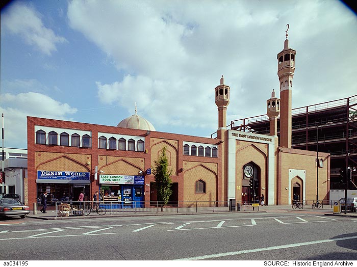
"title": "East London Mosque in 2003, photograph by Derek Kendall",
"author": {
"id": 37,
"username": "HistoricEngland"
},
"feature": {
"id": 954,
"type": "Feature",
"geometry": {
"type": "MultiPolygon",
"coordinates": [
[
[
[
-0.065206797940897,
51.517271937377544
],
[
-0.065368160478329,
51.51726758221674
],
[
-0.065464443868283,
51.51715527010221
],
[
-0.065502188596469,
51.51726840963888
],
[
-0.065646714781408,
51.51723165960403
],
[
-0.065651813136799,
51.517240627922654
],
[
-0.065802326663853,
51.51746566611145
],
[
-0.06523942911892,
51.51762109725155
],
[
-0.065140866189073,
51.51749259191283
],
[
-0.065271082461908,
51.51745883581532
],
[
-0.065097819118116,
51.517403277731226
],
[
-0.065206797940897,
51.517271937377544
]
]
]
]
},
"properties": {
"b_number": "",
"b_name": "East London Mosque",
"street": "Whitechapel Road",
"address": "46 Whitechapel Road",
"feature_type": "WHITECHAPEL_BUILDING",
"count": 14,
"search_str": "East London Mosque"
},
"tags": [
"mosque"
]
},
"file": "https://surveyoflondon.org/media/uploads/features/954/aa034195.jpg",
"description": "reproduced by permission of the Historic England Archive (see archive.HistoricEngland.org.uk)",
"copyright": true,
"created": "2016-09-20"
},
{
"id": 402,
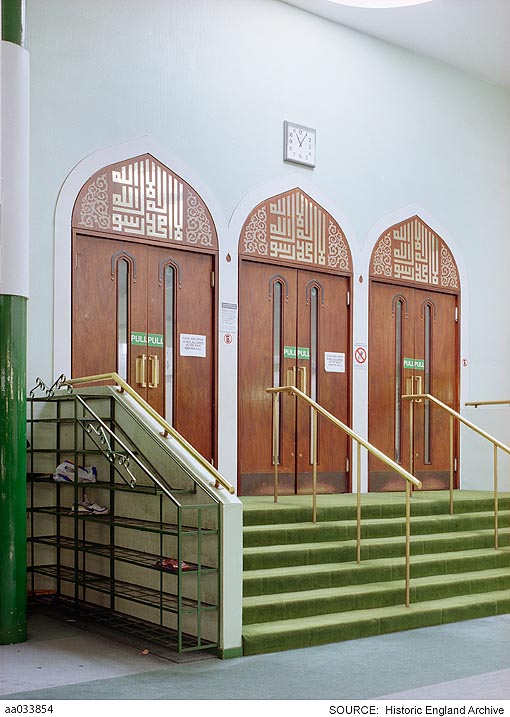
"title": "East London Mosque, doors into prayer hall in 2003, photograph by Derek Kendall",
"author": {
"id": 37,
"username": "HistoricEngland"
},
"feature": {
"id": 954,
"type": "Feature",
"geometry": {
"type": "MultiPolygon",
"coordinates": [
[
[
[
-0.065206797940897,
51.517271937377544
],
[
-0.065368160478329,
51.51726758221674
],
[
-0.065464443868283,
51.51715527010221
],
[
-0.065502188596469,
51.51726840963888
],
[
-0.065646714781408,
51.51723165960403
],
[
-0.065651813136799,
51.517240627922654
],
[
-0.065802326663853,
51.51746566611145
],
[
-0.06523942911892,
51.51762109725155
],
[
-0.065140866189073,
51.51749259191283
],
[
-0.065271082461908,
51.51745883581532
],
[
-0.065097819118116,
51.517403277731226
],
[
-0.065206797940897,
51.517271937377544
]
]
]
]
},
"properties": {
"b_number": "",
"b_name": "East London Mosque",
"street": "Whitechapel Road",
"address": "46 Whitechapel Road",
"feature_type": "WHITECHAPEL_BUILDING",
"count": 14,
"search_str": "East London Mosque"
},
"tags": [
"mosque"
]
},
"file": "https://surveyoflondon.org/media/uploads/features/954/aa033854.jpg",
"description": "reproduced by permission of the Historic England Archive (see archive.HistoricEngland.org.uk)",
"copyright": true,
"created": "2016-09-20"
},
{
"id": 643,
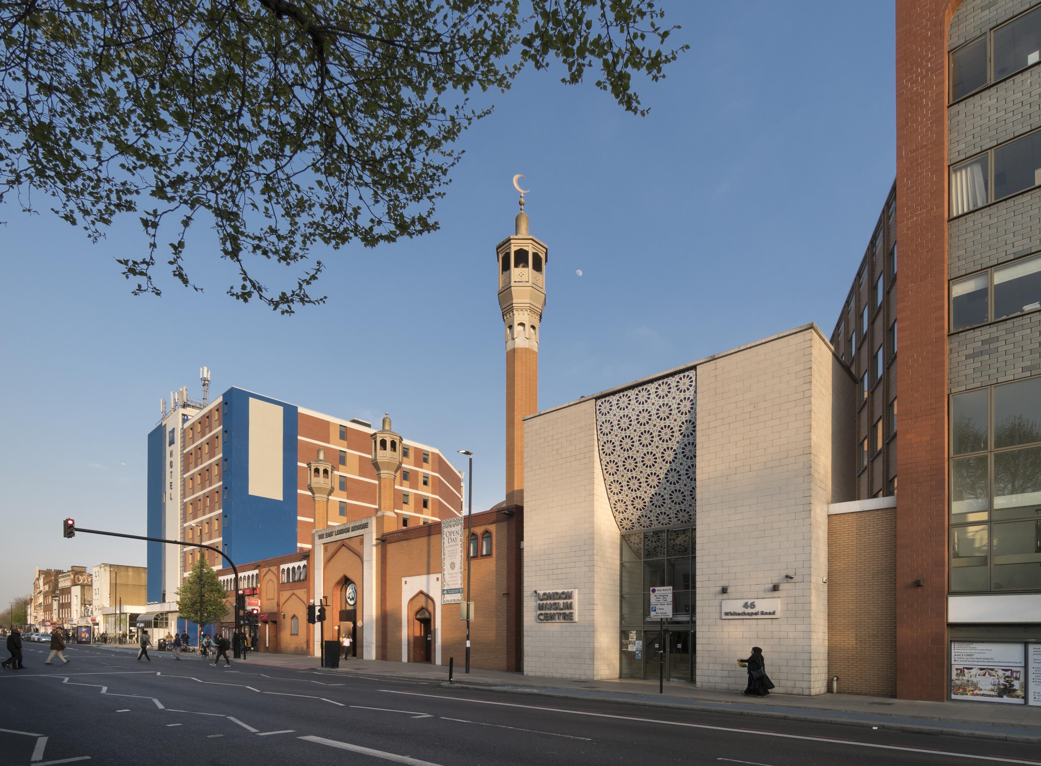
"title": "East London Mosque and London Muslim Centre, April 2017",
"author": {
"id": 27,
"username": "DerekKendall"
},
"feature": {
"id": 954,
"type": "Feature",
"geometry": {
"type": "MultiPolygon",
"coordinates": [
[
[
[
-0.065206797940897,
51.517271937377544
],
[
-0.065368160478329,
51.51726758221674
],
[
-0.065464443868283,
51.51715527010221
],
[
-0.065502188596469,
51.51726840963888
],
[
-0.065646714781408,
51.51723165960403
],
[
-0.065651813136799,
51.517240627922654
],
[
-0.065802326663853,
51.51746566611145
],
[
-0.06523942911892,
51.51762109725155
],
[
-0.065140866189073,
51.51749259191283
],
[
-0.065271082461908,
51.51745883581532
],
[
-0.065097819118116,
51.517403277731226
],
[
-0.065206797940897,
51.517271937377544
]
]
]
]
},
"properties": {
"b_number": "",
"b_name": "East London Mosque",
"street": "Whitechapel Road",
"address": "46 Whitechapel Road",
"feature_type": "WHITECHAPEL_BUILDING",
"count": 14,
"search_str": "East London Mosque"
},
"tags": [
"mosque"
]
},
"file": "https://surveyoflondon.org/media/uploads/features/954/SoL%20Whitechapel%20100741.jpg",
"description": "",
"copyright": true,
"created": "2017-05-03"
},
{
"id": 644,
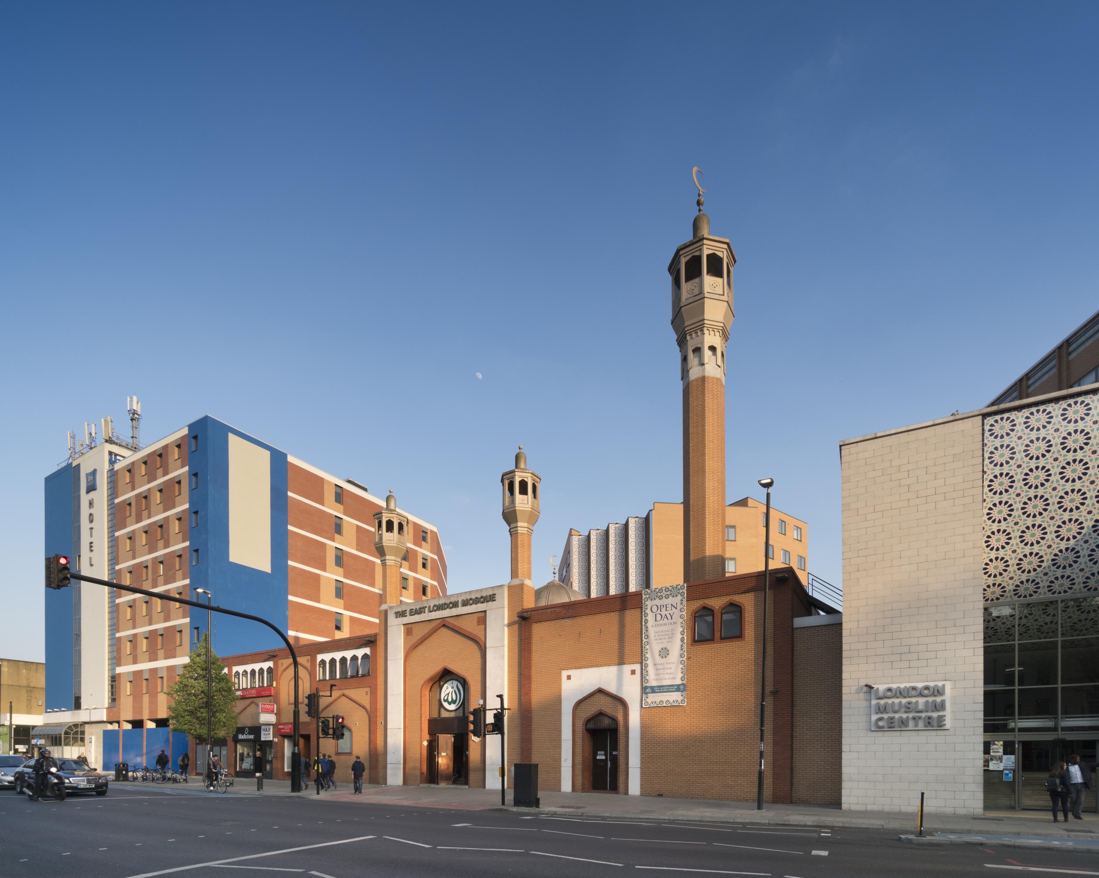
"title": "East London Mosque, April 2017",
"author": {
"id": 27,
"username": "DerekKendall"
},
"feature": {
"id": 954,
"type": "Feature",
"geometry": {
"type": "MultiPolygon",
"coordinates": [
[
[
[
-0.065206797940897,
51.517271937377544
],
[
-0.065368160478329,
51.51726758221674
],
[
-0.065464443868283,
51.51715527010221
],
[
-0.065502188596469,
51.51726840963888
],
[
-0.065646714781408,
51.51723165960403
],
[
-0.065651813136799,
51.517240627922654
],
[
-0.065802326663853,
51.51746566611145
],
[
-0.06523942911892,
51.51762109725155
],
[
-0.065140866189073,
51.51749259191283
],
[
-0.065271082461908,
51.51745883581532
],
[
-0.065097819118116,
51.517403277731226
],
[
-0.065206797940897,
51.517271937377544
]
]
]
]
},
"properties": {
"b_number": "",
"b_name": "East London Mosque",
"street": "Whitechapel Road",
"address": "46 Whitechapel Road",
"feature_type": "WHITECHAPEL_BUILDING",
"count": 14,
"search_str": "East London Mosque"
},
"tags": [
"mosque"
]
},
"file": "https://surveyoflondon.org/media/uploads/features/954/SoL%20Whitechapel%20100744.jpg",
"description": "",
"copyright": true,
"created": "2017-05-03"
},
{
"id": 1698,
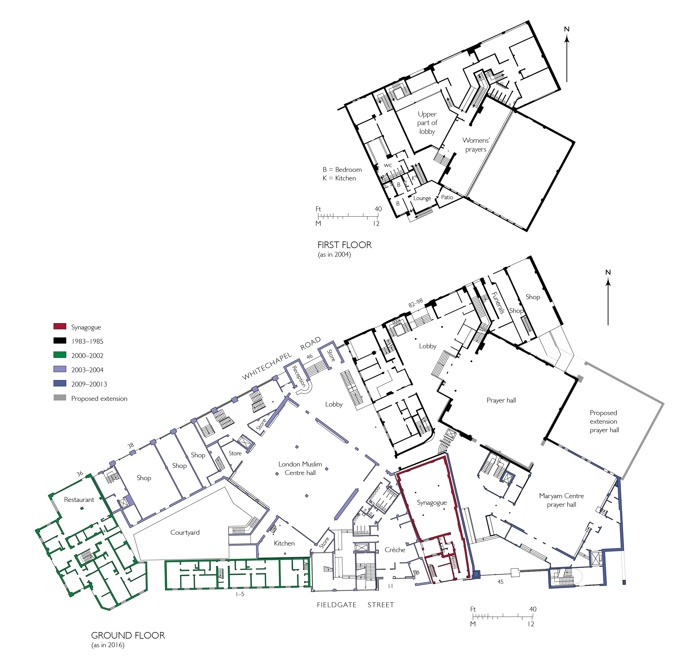
"title": "East London Mosque and associated buildings, ground-floor plans as in 2016, with first-floor plan of the mosque only as in 2004",
"author": {
"id": 82,
"username": "HelenJones"
},
"feature": {
"id": 954,
"type": "Feature",
"geometry": {
"type": "MultiPolygon",
"coordinates": [
[
[
[
-0.065206797940897,
51.517271937377544
],
[
-0.065368160478329,
51.51726758221674
],
[
-0.065464443868283,
51.51715527010221
],
[
-0.065502188596469,
51.51726840963888
],
[
-0.065646714781408,
51.51723165960403
],
[
-0.065651813136799,
51.517240627922654
],
[
-0.065802326663853,
51.51746566611145
],
[
-0.06523942911892,
51.51762109725155
],
[
-0.065140866189073,
51.51749259191283
],
[
-0.065271082461908,
51.51745883581532
],
[
-0.065097819118116,
51.517403277731226
],
[
-0.065206797940897,
51.517271937377544
]
]
]
]
},
"properties": {
"b_number": "",
"b_name": "East London Mosque",
"street": "Whitechapel Road",
"address": "46 Whitechapel Road",
"feature_type": "WHITECHAPEL_BUILDING",
"count": 14,
"search_str": "East London Mosque"
},
"tags": [
"mosque"
]
},
"file": "https://surveyoflondon.org/media/uploads/features/954/Elm%20Ground%20floor%20and%20first%20floor%20combined.jpg",
"description": "",
"copyright": true,
"created": "2020-05-11"
},
{
"id": 1741,
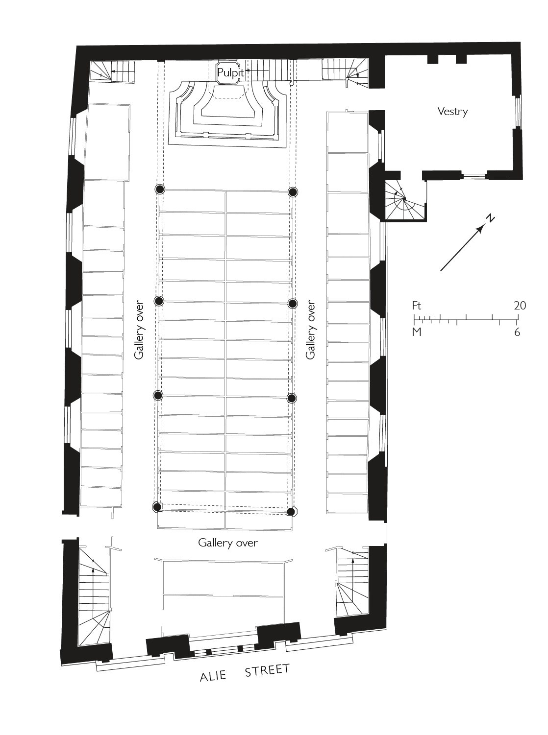
"title": "St George's German Lutheran Church, plan as built in 1762–6, drawing by Helen Jones based on a measured survey by Andrew Donald",
"author": {
"id": 2,
"username": "surveyoflondon"
},
"feature": {
"id": 17,
"type": "Feature",
"geometry": {
"type": "MultiPolygon",
"coordinates": [
[
[
[
-0.07063554499044,
51.514165253062664
],
[
-0.070405394989044,
51.5142577505096
],
[
-0.070368459316428,
51.51421883204737
],
[
-0.070427800505043,
51.51419483274977
],
[
-0.070359330002431,
51.51412101663757
],
[
-0.070376872840001,
51.514112887757804
],
[
-0.070313812852201,
51.514054169773665
],
[
-0.070469168765051,
51.51398880154131
],
[
-0.07063554499044,
51.514165253062664
]
]
]
]
},
"properties": {
"b_number": "55",
"b_name": "St George’s German Lutheran Church",
"street": "Alie Street",
"address": "St George’s German Lutheran Church, 55 Alie Street",
"feature_type": "WHITECHAPEL_BUILDING",
"count": 8,
"search_str": "St George’s German Lutheran Church"
},
"tags": [
"church",
"lutheran"
]
},
"file": "https://surveyoflondon.org/media/uploads/features/17/St%20Georges%20Church%20plan.jpg",
"description": "",
"copyright": true,
"created": "2020-08-03"
},
{
"id": 479,
"title": "Browne & Eagle in Loom House",
"author": {
"id": 72,
"username": "eric"
},
"feature": {
"id": 1054,
"type": "Feature",
"geometry": {
"type": "MultiPolygon",
"coordinates": [
[
[
[
-0.067624988998484,
51.51289617869746
],
[
-0.067180798939432,
51.512911920220176
],
[
-0.067133711242303,
51.512567481740106
],
[
-0.067109487043094,
51.512455102488246
],
[
-0.067094022808022,
51.51237277531417
],
[
-0.067355415992025,
51.51233326528946
],
[
-0.067556363832002,
51.51229971390102
],
[
-0.067559932926382,
51.512347068603766
],
[
-0.067564604000022,
51.512473731628916
],
[
-0.06762108926581,
51.51287737297797
],
[
-0.067624988998484,
51.51289617869746
]
]
]
]
},
"properties": {
"b_number": "101",
"b_name": "The Loom, 101 Back Church Lane",
"street": "Back Church Lane",
"address": "The Loom, 101 Back Church Lane",
"feature_type": "WHITECHAPEL_BUILDING",
"count": 10,
"search_str": "The Loom, 101 Back Church Lane"
},
"tags": []
},
"file": "https://surveyoflondon.org/media/uploads/features/1054/gowerbottom.jpg",
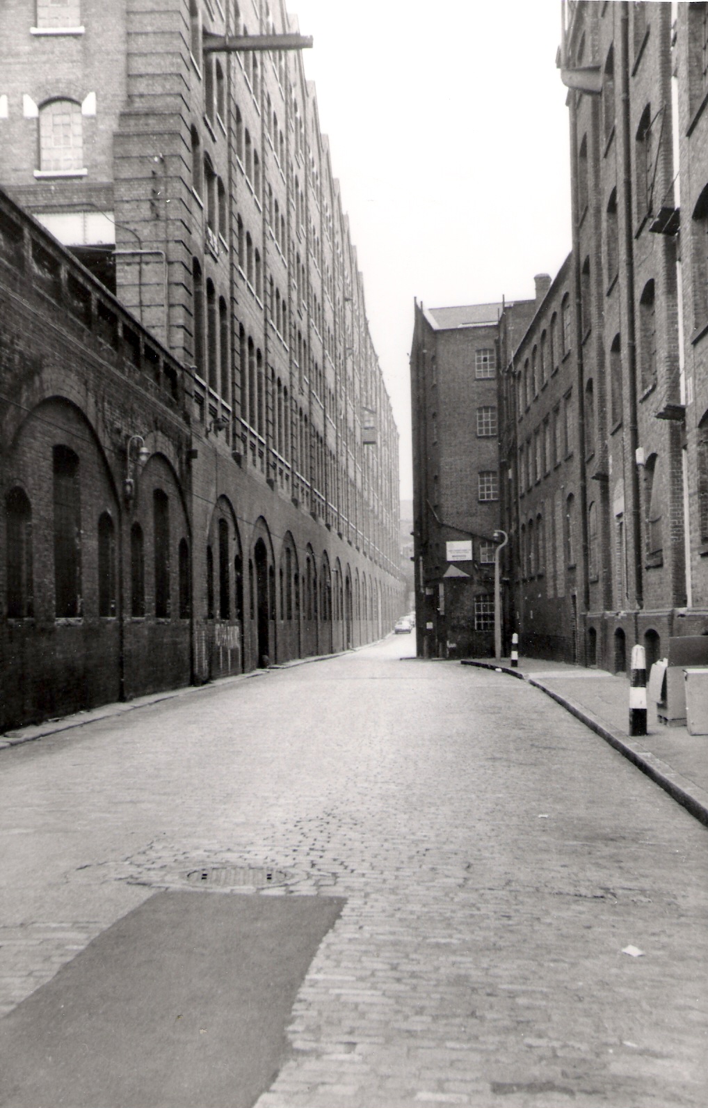
"description": "View of Loom House from south end of Gower's Walk, when it was used by Browne & Eagle for storing/assessing bales of imported wool. The 'Tilbury' Warehouse (with railway) still present then on the left, and a portion of the building at the north end of New Loom House then partly obstructed both Gower's Walk and the view northwards to Commercial Road.",
"copyright": false,
"created": "2017-01-15"
},
{
"id": 1564,
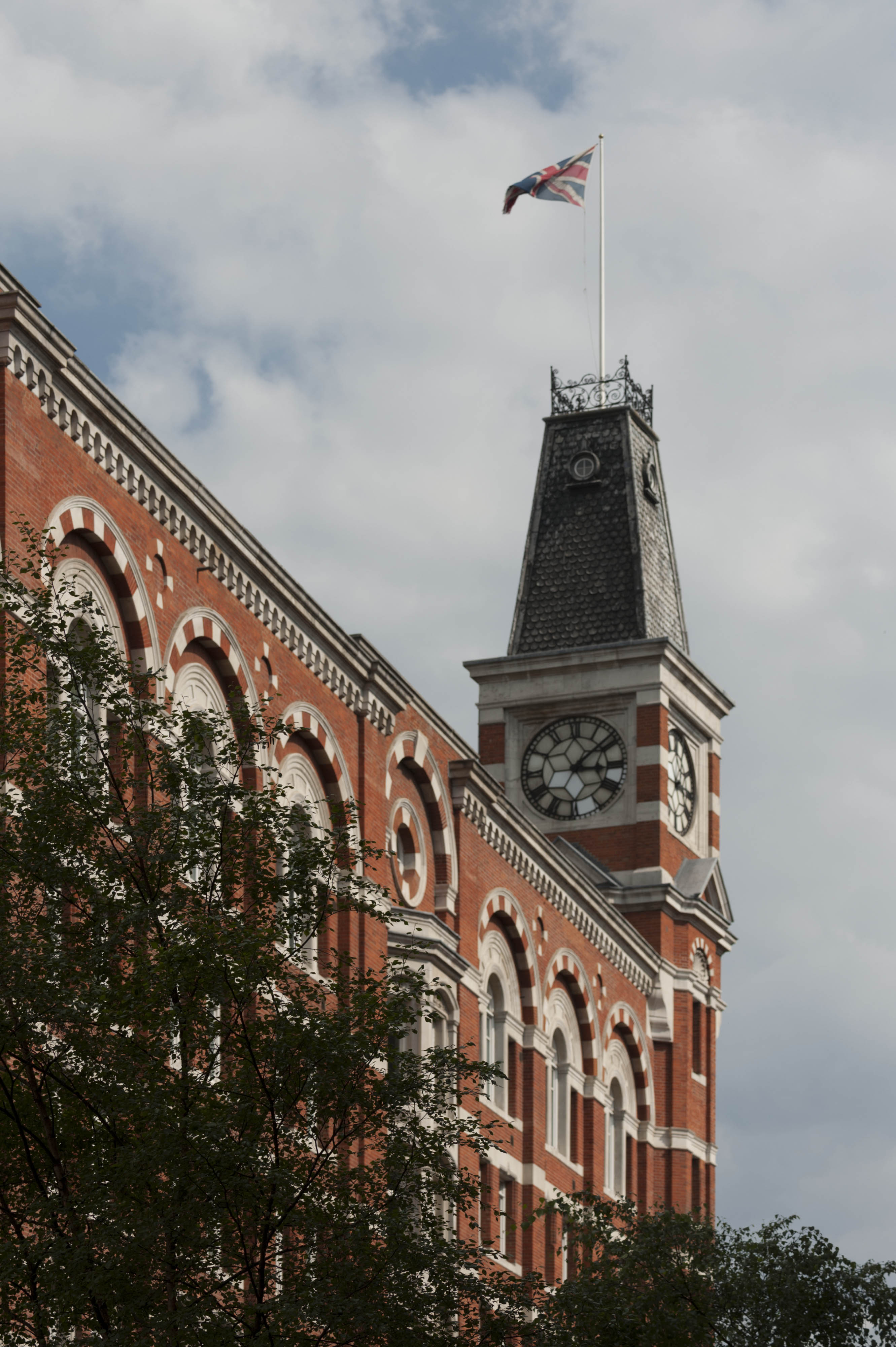
"title": "Sugar House, clock tower from the northwest in 2017",
"author": {
"id": 27,
"username": "DerekKendall"
},
"feature": {
"id": 1264,
"type": "Feature",
"geometry": {
"type": "MultiPolygon",
"coordinates": [
[
[
[
-0.069331963951854,
51.51229594729769
],
[
-0.069137875560046,
51.512351392206085
],
[
-0.068952695054468,
51.51210160696183
],
[
-0.06877706008966,
51.51212449662561
],
[
-0.068766393531184,
51.5121102580591
],
[
-0.068775926288607,
51.51210689932468
],
[
-0.068782151200721,
51.51209293893689
],
[
-0.068742154431936,
51.5120172780914
],
[
-0.068763790231903,
51.51199419623458
],
[
-0.069027145444056,
51.51193993762725
],
[
-0.06905682792721,
51.51194862974888
],
[
-0.069331963951854,
51.51229594729769
]
]
]
]
},
"properties": {
"b_number": "99",
"b_name": "Sugar House, 99 Leman Street",
"street": "Leman Street",
"address": "Sugar House, 99 Leman Street",
"feature_type": "WHITECHAPEL_BUILDING",
"count": 21,
"search_str": "Sugar House, 99 Leman Street"
},
"tags": [
"Co-operative Wholesale Society"
]
},
"file": "https://surveyoflondon.org/media/uploads/features/1264/SoL%20Whitechapel%20101081.jpg",
"description": "",
"copyright": true,
"created": "2019-03-20"
},
{
"id": 1737,
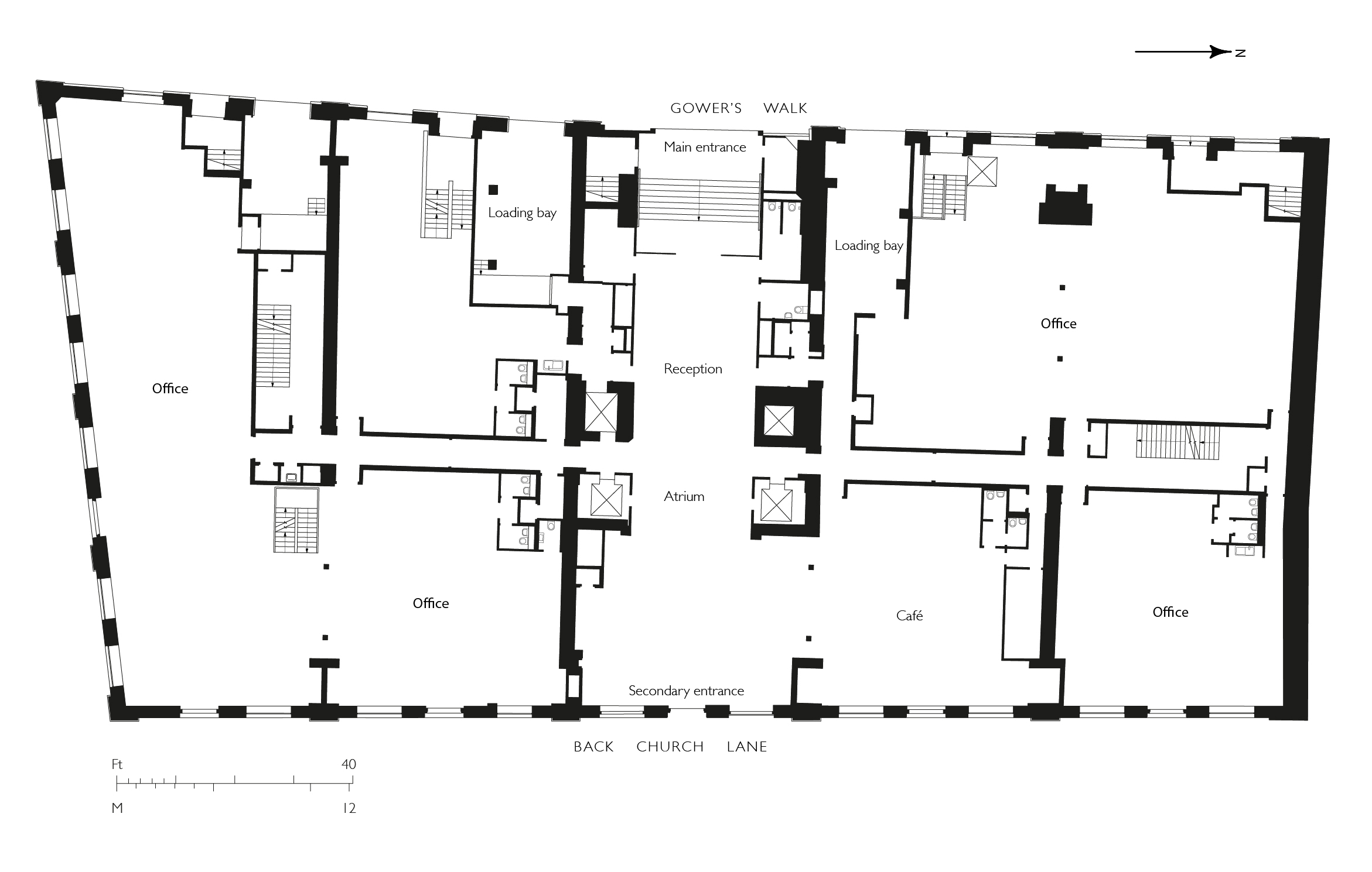
"title": "The Loom, ground-floor plan in 2017, drawing by Helen Jones adapted from Duggan Morris",
"author": {
"id": 2,
"username": "surveyoflondon"
},
"feature": {
"id": 1054,
"type": "Feature",
"geometry": {
"type": "MultiPolygon",
"coordinates": [
[
[
[
-0.067624988998484,
51.51289617869746
],
[
-0.067180798939432,
51.512911920220176
],
[
-0.067133711242303,
51.512567481740106
],
[
-0.067109487043094,
51.512455102488246
],
[
-0.067094022808022,
51.51237277531417
],
[
-0.067355415992025,
51.51233326528946
],
[
-0.067556363832002,
51.51229971390102
],
[
-0.067559932926382,
51.512347068603766
],
[
-0.067564604000022,
51.512473731628916
],
[
-0.06762108926581,
51.51287737297797
],
[
-0.067624988998484,
51.51289617869746
]
]
]
]
},
"properties": {
"b_number": "101",
"b_name": "The Loom, 101 Back Church Lane",
"street": "Back Church Lane",
"address": "The Loom, 101 Back Church Lane",
"feature_type": "WHITECHAPEL_BUILDING",
"count": 10,
"search_str": "The Loom, 101 Back Church Lane"
},
"tags": []
},
"file": "https://surveyoflondon.org/media/uploads/features/1054/Loom%20House%20plan%202.jpg",
"description": "",
"copyright": true,
"created": "2020-07-30"
},
{
"id": 1765,
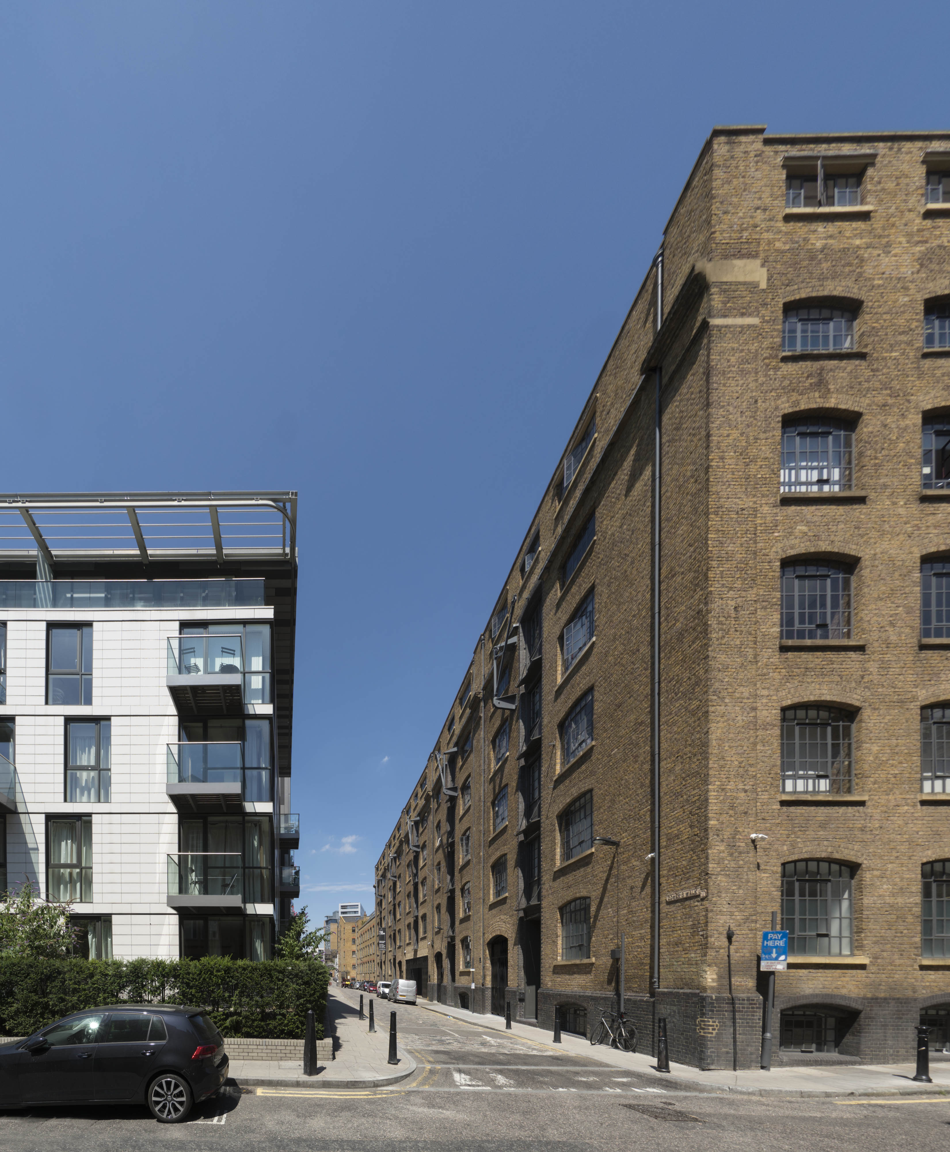
"title": "Gower's Walk from the south in 2017, the Loom to the east",
"author": {
"id": 27,
"username": "DerekKendall"
},
"feature": {
"id": 1054,
"type": "Feature",
"geometry": {
"type": "MultiPolygon",
"coordinates": [
[
[
[
-0.067624988998484,
51.51289617869746
],
[
-0.067180798939432,
51.512911920220176
],
[
-0.067133711242303,
51.512567481740106
],
[
-0.067109487043094,
51.512455102488246
],
[
-0.067094022808022,
51.51237277531417
],
[
-0.067355415992025,
51.51233326528946
],
[
-0.067556363832002,
51.51229971390102
],
[
-0.067559932926382,
51.512347068603766
],
[
-0.067564604000022,
51.512473731628916
],
[
-0.06762108926581,
51.51287737297797
],
[
-0.067624988998484,
51.51289617869746
]
]
]
]
},
"properties": {
"b_number": "101",
"b_name": "The Loom, 101 Back Church Lane",
"street": "Back Church Lane",
"address": "The Loom, 101 Back Church Lane",
"feature_type": "WHITECHAPEL_BUILDING",
"count": 10,
"search_str": "The Loom, 101 Back Church Lane"
},
"tags": []
},
"file": "https://surveyoflondon.org/media/uploads/features/1054/SoL%20Whitechapel%20101031.jpg",
"description": "",
"copyright": true,
"created": "2020-08-04"
},
{
"id": 1766,
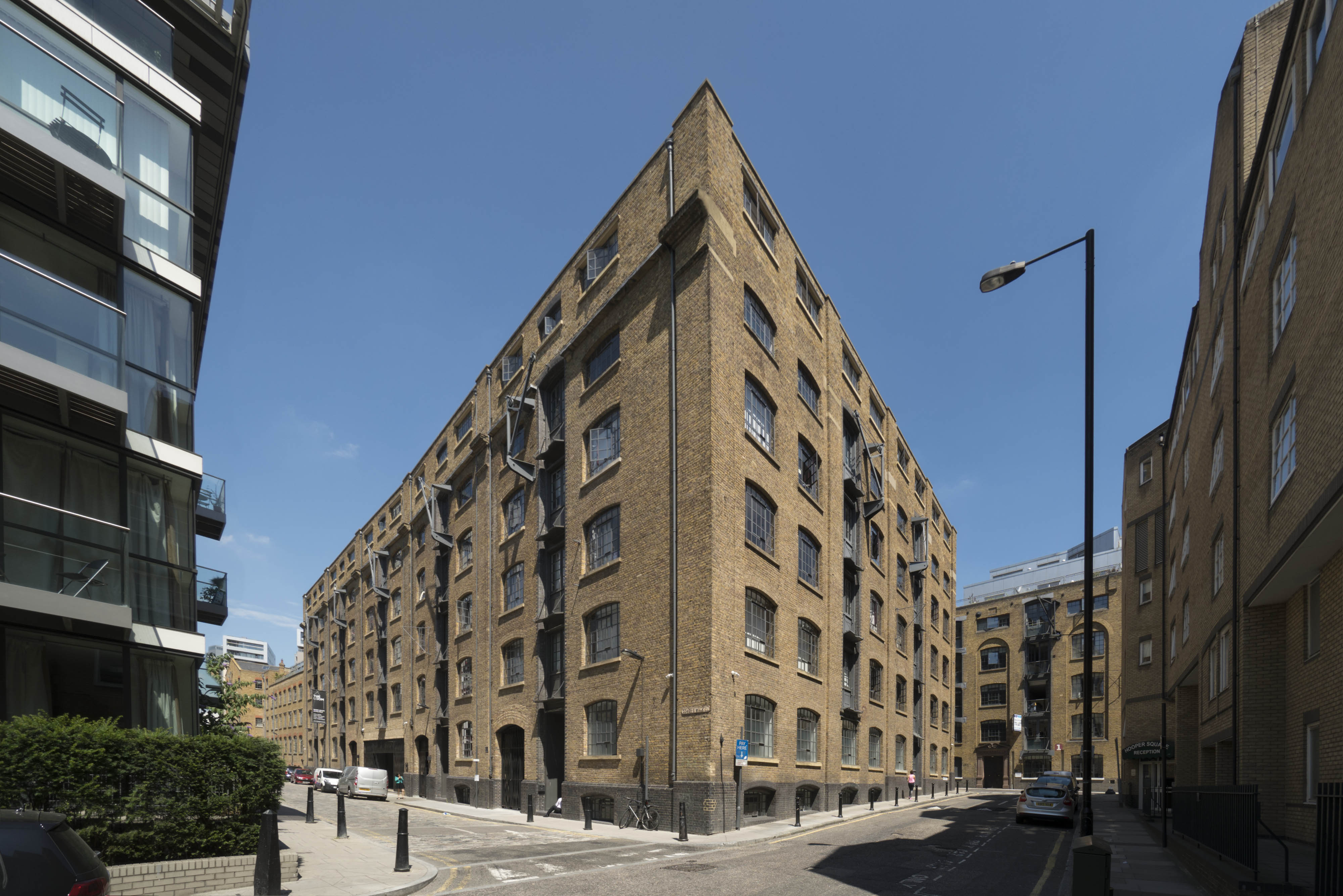
"title": "The Loom from the south-west in 2017",
"author": {
"id": 27,
"username": "DerekKendall"
},
"feature": {
"id": 1054,
"type": "Feature",
"geometry": {
"type": "MultiPolygon",
"coordinates": [
[
[
[
-0.067624988998484,
51.51289617869746
],
[
-0.067180798939432,
51.512911920220176
],
[
-0.067133711242303,
51.512567481740106
],
[
-0.067109487043094,
51.512455102488246
],
[
-0.067094022808022,
51.51237277531417
],
[
-0.067355415992025,
51.51233326528946
],
[
-0.067556363832002,
51.51229971390102
],
[
-0.067559932926382,
51.512347068603766
],
[
-0.067564604000022,
51.512473731628916
],
[
-0.06762108926581,
51.51287737297797
],
[
-0.067624988998484,
51.51289617869746
]
]
]
]
},
"properties": {
"b_number": "101",
"b_name": "The Loom, 101 Back Church Lane",
"street": "Back Church Lane",
"address": "The Loom, 101 Back Church Lane",
"feature_type": "WHITECHAPEL_BUILDING",
"count": 10,
"search_str": "The Loom, 101 Back Church Lane"
},
"tags": []
},
"file": "https://surveyoflondon.org/media/uploads/features/1054/SoL%20Whitechapel%20101034.jpg",
"description": "",
"copyright": true,
"created": "2020-08-04"
},
{
"id": 1266,
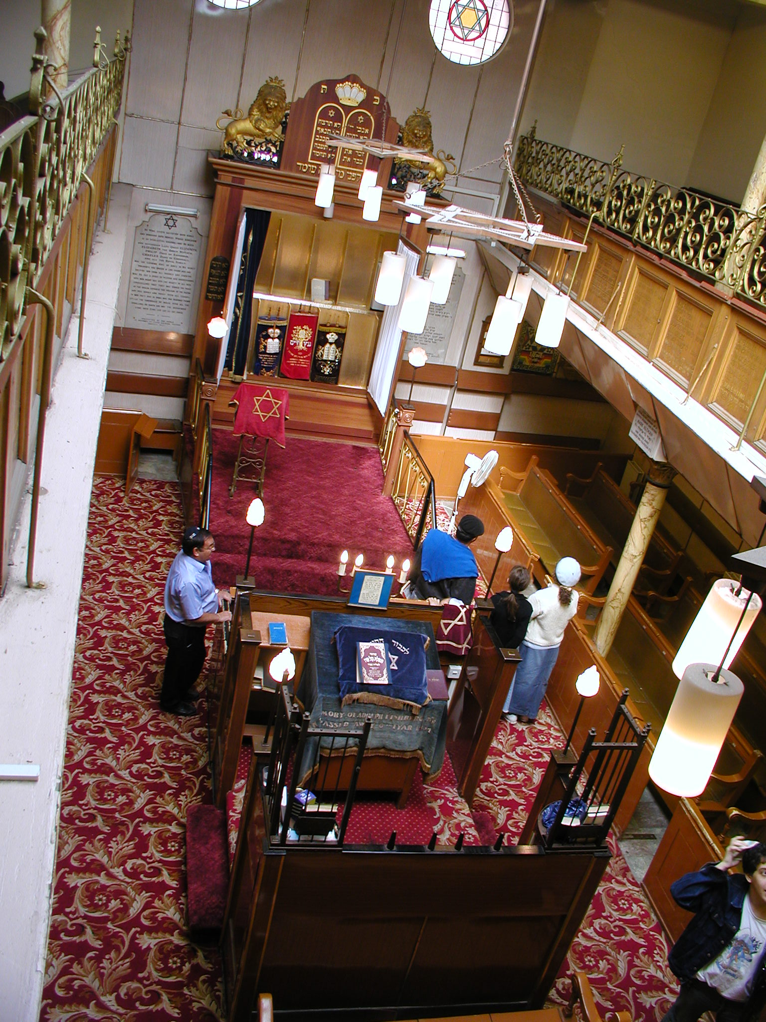
"title": "Fieldgate Street Great Synagogue in 2003, view of the interior from the south gallery",
"author": {
"id": 10,
"username": "PGuillery"
},
"feature": {
"id": 837,
"type": "Feature",
"geometry": {
"type": "MultiPolygon",
"coordinates": [
[
[
[
-0.065533721939634,
51.51703253016194
],
[
-0.065646714781391,
51.517231659604
],
[
-0.065502188596495,
51.517268409638795
],
[
-0.065426771021086,
51.51704234602821
],
[
-0.065533721939634,
51.51703253016194
]
]
]
]
},
"properties": {
"b_number": "41",
"b_name": "Former Fieldgate Street Great Synagogue",
"street": "Fieldgate Street",
"address": "Former Fieldgate Street Great Synagogue, 41 Fieldgate Street",
"feature_type": "WHITECHAPEL_BUILDING",
"count": 16,
"search_str": "Former Fieldgate Street Great Synagogue"
},
"tags": [
"synagogue"
]
},
"file": "https://surveyoflondon.org/media/uploads/features/837/P1010049.JPG",
"description": "",
"copyright": false,
"created": "2018-06-06"
},
{
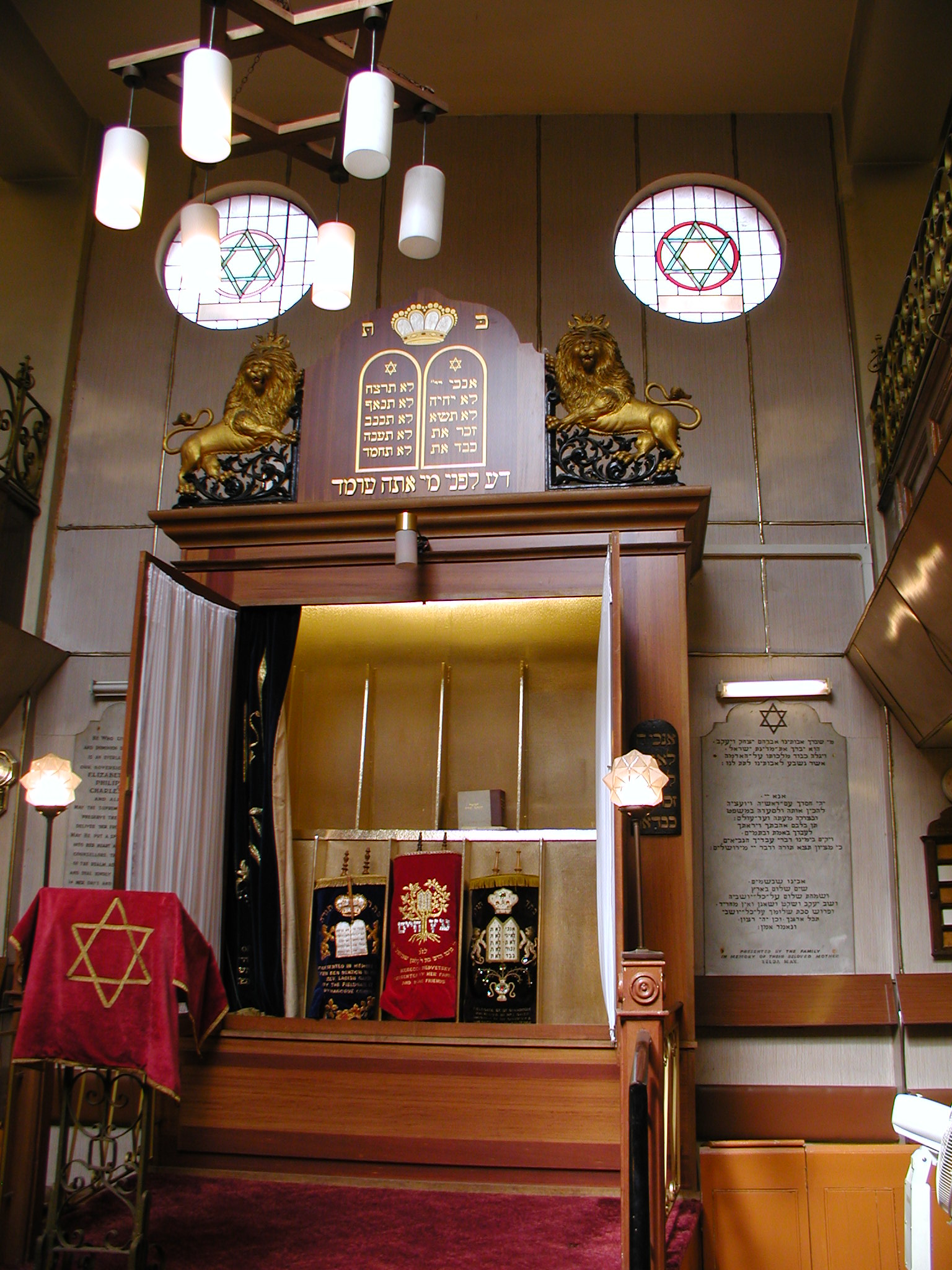
"id": 1267,
"title": "Fieldgate Street Great Synagogue in 2003, view to the Ark on the north wall",
"author": {
"id": 10,
"username": "PGuillery"
},
"feature": {
"id": 837,
"type": "Feature",
"geometry": {
"type": "MultiPolygon",
"coordinates": [
[
[
[
-0.065533721939634,
51.51703253016194
],
[
-0.065646714781391,
51.517231659604
],
[
-0.065502188596495,
51.517268409638795
],
[
-0.065426771021086,
51.51704234602821
],
[
-0.065533721939634,
51.51703253016194
]
]
]
]
},
"properties": {
"b_number": "41",
"b_name": "Former Fieldgate Street Great Synagogue",
"street": "Fieldgate Street",
"address": "Former Fieldgate Street Great Synagogue, 41 Fieldgate Street",
"feature_type": "WHITECHAPEL_BUILDING",
"count": 16,
"search_str": "Former Fieldgate Street Great Synagogue"
},
"tags": [
"synagogue"
]
},
"file": "https://surveyoflondon.org/media/uploads/features/837/P1010047.JPG",
"description": "",
"copyright": false,
"created": "2018-06-06"
},
{
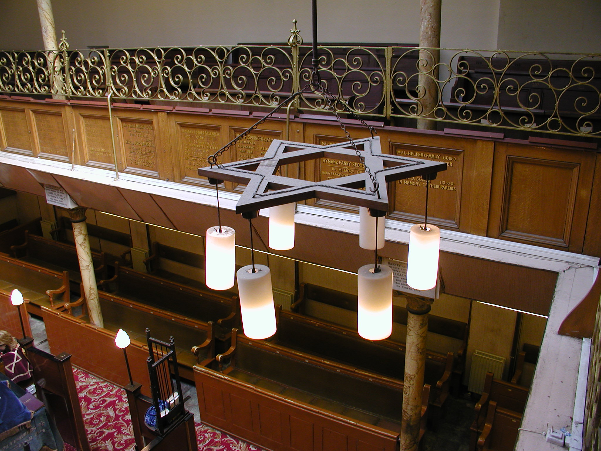
"id": 1268,
"title": "Fieldgate Street synagogue in 2003, view across the gallery looking east",
"author": {
"id": 10,
"username": "PGuillery"
},
"feature": {
"id": 837,
"type": "Feature",
"geometry": {
"type": "MultiPolygon",
"coordinates": [
[
[
[
-0.065533721939634,
51.51703253016194
],
[
-0.065646714781391,
51.517231659604
],
[
-0.065502188596495,
51.517268409638795
],
[
-0.065426771021086,
51.51704234602821
],
[
-0.065533721939634,
51.51703253016194
]
]
]
]
},
"properties": {
"b_number": "41",
"b_name": "Former Fieldgate Street Great Synagogue",
"street": "Fieldgate Street",
"address": "Former Fieldgate Street Great Synagogue, 41 Fieldgate Street",
"feature_type": "WHITECHAPEL_BUILDING",
"count": 16,
"search_str": "Former Fieldgate Street Great Synagogue"
},
"tags": [
"synagogue"
]
},
"file": "https://surveyoflondon.org/media/uploads/features/837/P1010050.JPG",
"description": "",
"copyright": false,
"created": "2018-06-06"
},
{
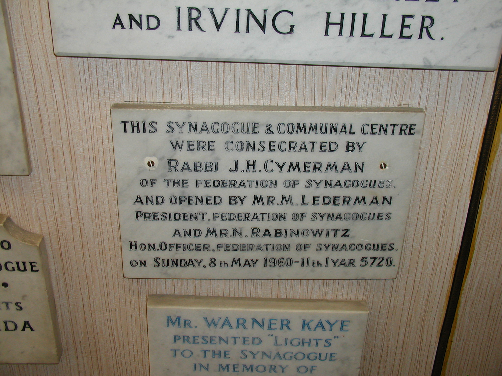
"id": 1269,
"title": "Fieldgate Street Great Synagogue in 2003, dedicatory inscription in entrance passage",
"author": {
"id": 10,
"username": "PGuillery"
},
"feature": {
"id": 837,
"type": "Feature",
"geometry": {
"type": "MultiPolygon",
"coordinates": [
[
[
[
-0.065533721939634,
51.51703253016194
],
[
-0.065646714781391,
51.517231659604
],
[
-0.065502188596495,
51.517268409638795
],
[
-0.065426771021086,
51.51704234602821
],
[
-0.065533721939634,
51.51703253016194
]
]
]
]
},
"properties": {
"b_number": "41",
"b_name": "Former Fieldgate Street Great Synagogue",
"street": "Fieldgate Street",
"address": "Former Fieldgate Street Great Synagogue, 41 Fieldgate Street",
"feature_type": "WHITECHAPEL_BUILDING",
"count": 16,
"search_str": "Former Fieldgate Street Great Synagogue"
},
"tags": [
"synagogue"
]
},
"file": "https://surveyoflondon.org/media/uploads/features/837/P1010061.JPG",
"description": "",
"copyright": false,
"created": "2018-06-06"
},
{
"id": 1565,
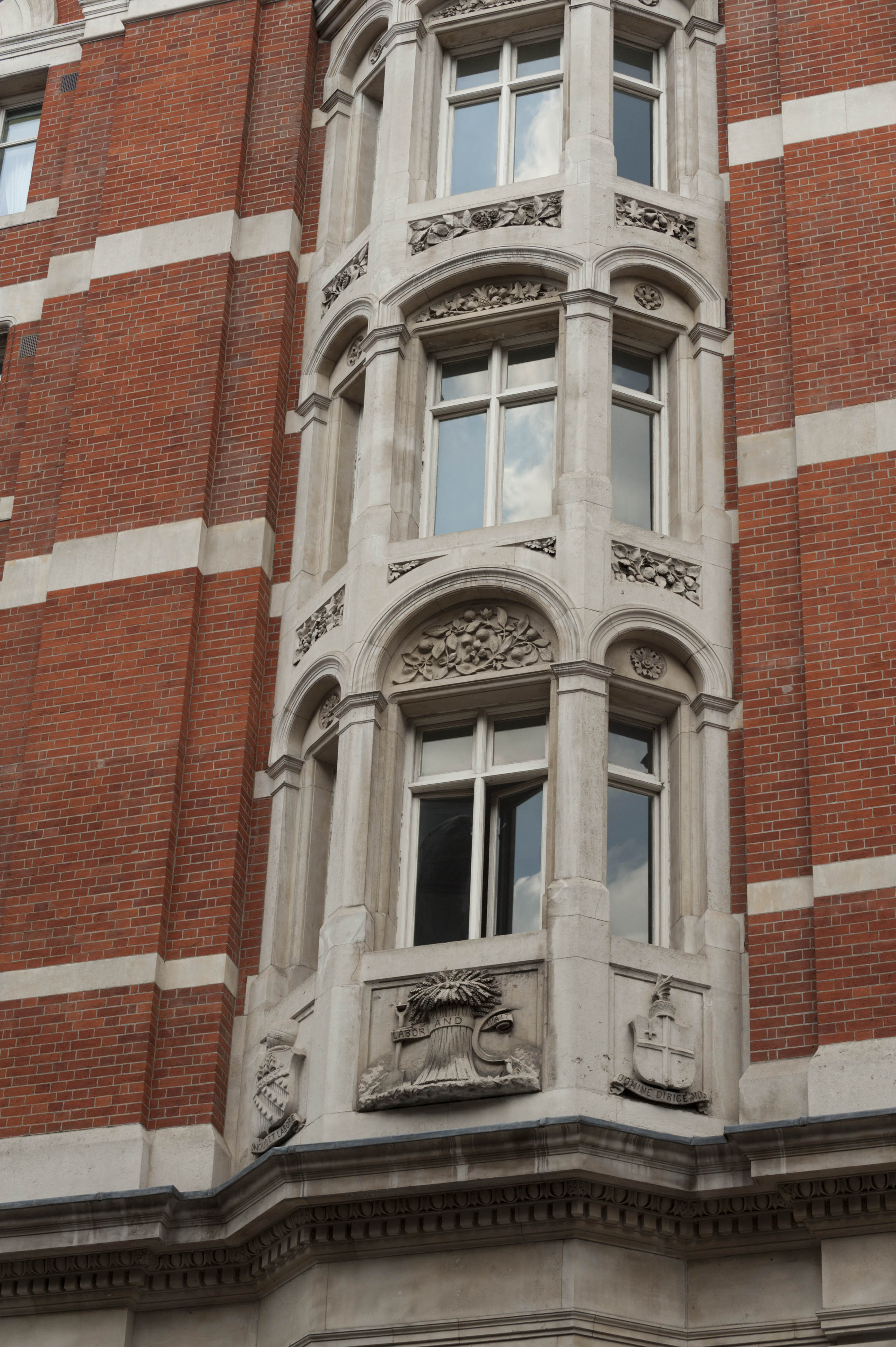
"title": "Sugar House, bay window detail in 2017",
"author": {
"id": 27,
"username": "DerekKendall"
},
"feature": {
"id": 1264,
"type": "Feature",
"geometry": {
"type": "MultiPolygon",
"coordinates": [
[
[
[
-0.069331963951854,
51.51229594729769
],
[
-0.069137875560046,
51.512351392206085
],
[
-0.068952695054468,
51.51210160696183
],
[
-0.06877706008966,
51.51212449662561
],
[
-0.068766393531184,
51.5121102580591
],
[
-0.068775926288607,
51.51210689932468
],
[
-0.068782151200721,
51.51209293893689
],
[
-0.068742154431936,
51.5120172780914
],
[
-0.068763790231903,
51.51199419623458
],
[
-0.069027145444056,
51.51193993762725
],
[
-0.06905682792721,
51.51194862974888
],
[
-0.069331963951854,
51.51229594729769
]
]
]
]
},
"properties": {
"b_number": "99",
"b_name": "Sugar House, 99 Leman Street",
"street": "Leman Street",
"address": "Sugar House, 99 Leman Street",
"feature_type": "WHITECHAPEL_BUILDING",
"count": 21,
"search_str": "Sugar House, 99 Leman Street"
},
"tags": [
"Co-operative Wholesale Society"
]
},
"file": "https://surveyoflondon.org/media/uploads/features/1264/SoL%20Whitechapel%20101084.jpg",
"description": "",
"copyright": true,
"created": "2019-03-20"
},
{
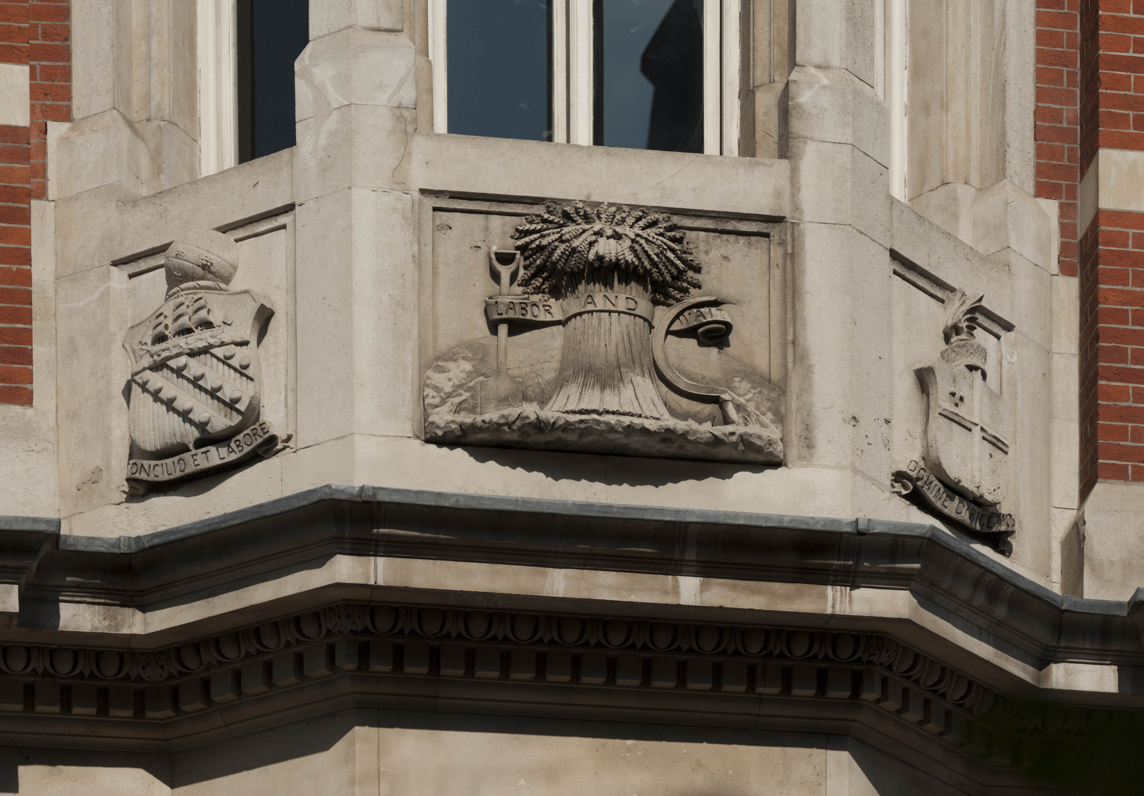
"id": 1566,
"title": "Sugar House, carved panels at base of bay window, 2017",
"author": {
"id": 27,
"username": "DerekKendall"
},
"feature": {
"id": 1264,
"type": "Feature",
"geometry": {
"type": "MultiPolygon",
"coordinates": [
[
[
[
-0.069331963951854,
51.51229594729769
],
[
-0.069137875560046,
51.512351392206085
],
[
-0.068952695054468,
51.51210160696183
],
[
-0.06877706008966,
51.51212449662561
],
[
-0.068766393531184,
51.5121102580591
],
[
-0.068775926288607,
51.51210689932468
],
[
-0.068782151200721,
51.51209293893689
],
[
-0.068742154431936,
51.5120172780914
],
[
-0.068763790231903,
51.51199419623458
],
[
-0.069027145444056,
51.51193993762725
],
[
-0.06905682792721,
51.51194862974888
],
[
-0.069331963951854,
51.51229594729769
]
]
]
]
},
"properties": {
"b_number": "99",
"b_name": "Sugar House, 99 Leman Street",
"street": "Leman Street",
"address": "Sugar House, 99 Leman Street",
"feature_type": "WHITECHAPEL_BUILDING",
"count": 21,
"search_str": "Sugar House, 99 Leman Street"
},
"tags": [
"Co-operative Wholesale Society"
]
},
"file": "https://surveyoflondon.org/media/uploads/features/1264/SoL%20Whitechapel%20101086.jpg",
"description": "",
"copyright": true,
"created": "2019-03-20"
},
{
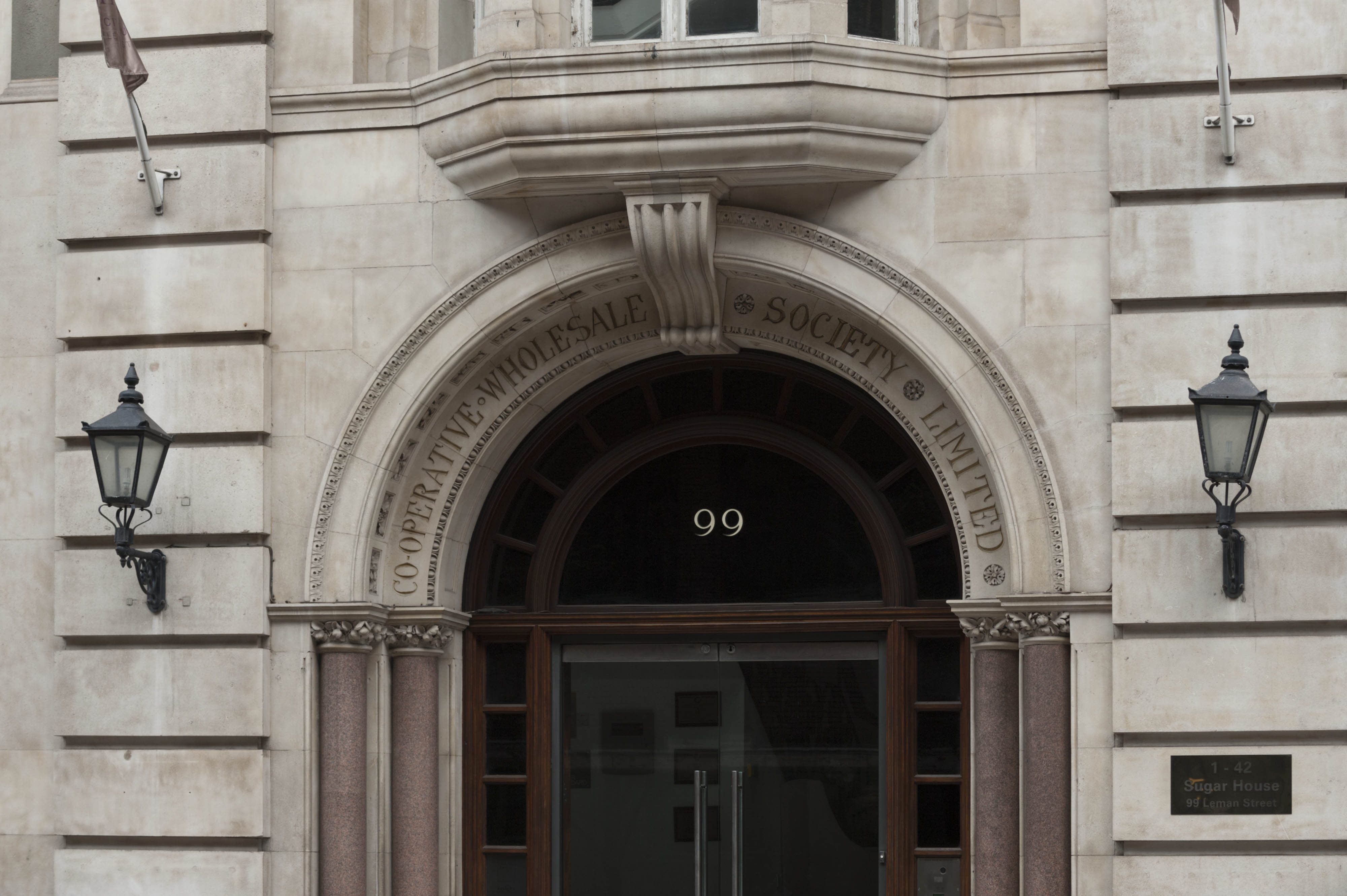
"id": 1567,
"title": "Sugar House, entrance detail in 2017",
"author": {
"id": 27,
"username": "DerekKendall"
},
"feature": {
"id": 1264,
"type": "Feature",
"geometry": {
"type": "MultiPolygon",
"coordinates": [
[
[
[
-0.069331963951854,
51.51229594729769
],
[
-0.069137875560046,
51.512351392206085
],
[
-0.068952695054468,
51.51210160696183
],
[
-0.06877706008966,
51.51212449662561
],
[
-0.068766393531184,
51.5121102580591
],
[
-0.068775926288607,
51.51210689932468
],
[
-0.068782151200721,
51.51209293893689
],
[
-0.068742154431936,
51.5120172780914
],
[
-0.068763790231903,
51.51199419623458
],
[
-0.069027145444056,
51.51193993762725
],
[
-0.06905682792721,
51.51194862974888
],
[
-0.069331963951854,
51.51229594729769
]
]
]
]
},
"properties": {
"b_number": "99",
"b_name": "Sugar House, 99 Leman Street",
"street": "Leman Street",
"address": "Sugar House, 99 Leman Street",
"feature_type": "WHITECHAPEL_BUILDING",
"count": 21,
"search_str": "Sugar House, 99 Leman Street"
},
"tags": [
"Co-operative Wholesale Society"
]
},
"file": "https://surveyoflondon.org/media/uploads/features/1264/SoL%20Whitechapel%20101090.jpg",
"description": "",
"copyright": true,
"created": "2019-03-20"
},
{
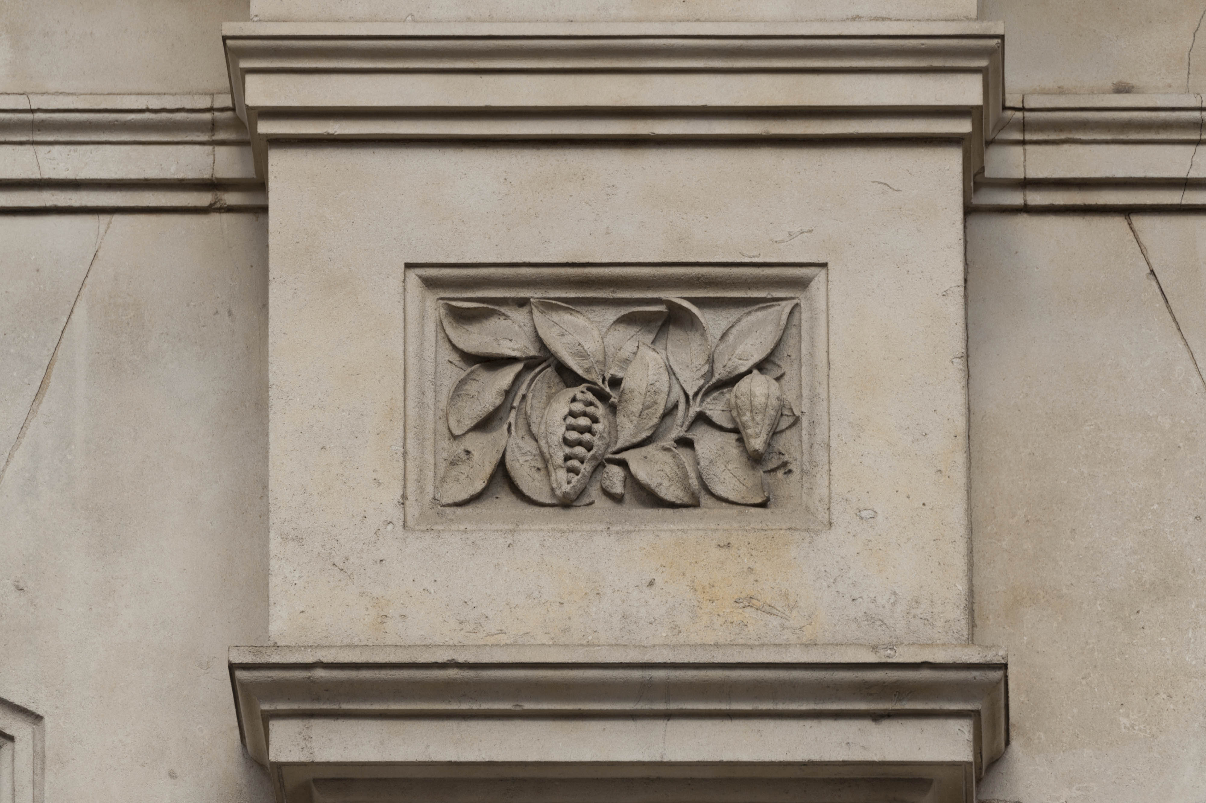
"id": 1568,
"title": "Sugar House, ornament detail, 2017",
"author": {
"id": 27,
"username": "DerekKendall"
},
"feature": {
"id": 1264,
"type": "Feature",
"geometry": {
"type": "MultiPolygon",
"coordinates": [
[
[
[
-0.069331963951854,
51.51229594729769
],
[
-0.069137875560046,
51.512351392206085
],
[
-0.068952695054468,
51.51210160696183
],
[
-0.06877706008966,
51.51212449662561
],
[
-0.068766393531184,
51.5121102580591
],
[
-0.068775926288607,
51.51210689932468
],
[
-0.068782151200721,
51.51209293893689
],
[
-0.068742154431936,
51.5120172780914
],
[
-0.068763790231903,
51.51199419623458
],
[
-0.069027145444056,
51.51193993762725
],
[
-0.06905682792721,
51.51194862974888
],
[
-0.069331963951854,
51.51229594729769
]
]
]
]
},
"properties": {
"b_number": "99",
"b_name": "Sugar House, 99 Leman Street",
"street": "Leman Street",
"address": "Sugar House, 99 Leman Street",
"feature_type": "WHITECHAPEL_BUILDING",
"count": 21,
"search_str": "Sugar House, 99 Leman Street"
},
"tags": [
"Co-operative Wholesale Society"
]
},
"file": "https://surveyoflondon.org/media/uploads/features/1264/SoL%20Whitechapel%20101091.jpg",
"description": "",
"copyright": true,
"created": "2019-03-20"
}
]
}