HTTP 200 OK
Allow: GET, HEAD, OPTIONS
Content-Type: application/json
Vary: Accept
{
"count": 1747,
"next": "https://surveyoflondon.org/api/v1/images/?format=api&page=77",
"previous": "https://surveyoflondon.org/api/v1/images/?format=api&page=75",
"results": [
{
"id": 519,
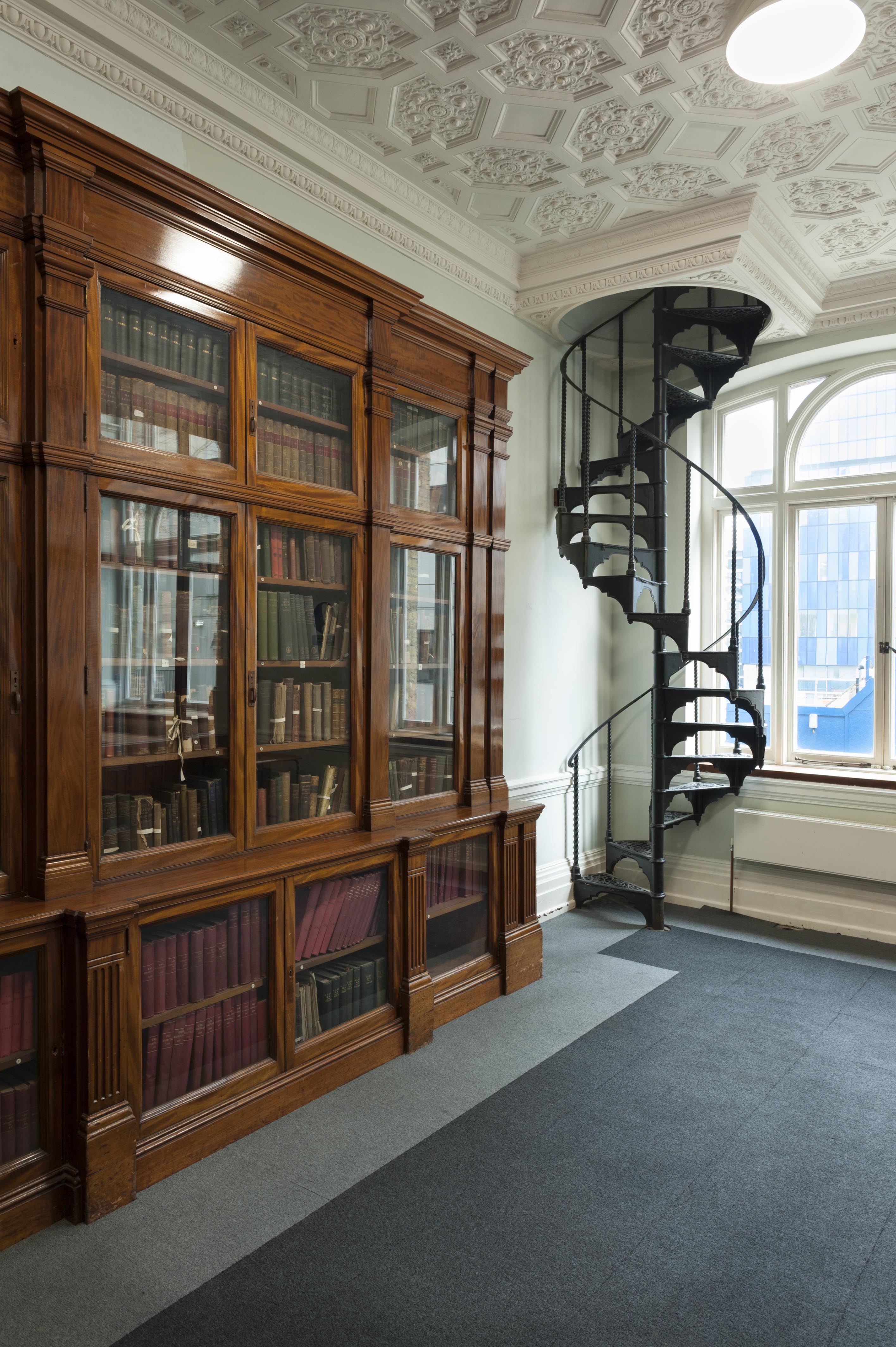
"title": "Wrought iron staircase in the Library of the Garrod Building",
"author": {
"id": 27,
"username": "DerekKendall"
},
"feature": {
"id": 1189,
"type": "Feature",
"geometry": {
"type": "MultiPolygon",
"coordinates": [
[
[
[
-0.060957318414032,
51.51782190843071
],
[
-0.060536358742238,
51.517916494366496
],
[
-0.06042382559955,
51.5177169757099
],
[
-0.060423392052643,
51.517716267459285
],
[
-0.06037583590265,
51.51772558880798
],
[
-0.060352091559155,
51.517682266082666
],
[
-0.060399184829325,
51.5176714337657
],
[
-0.060382136461735,
51.517636775872596
],
[
-0.060366794729858,
51.51763667842599
],
[
-0.060353568375337,
51.517633521256826
],
[
-0.060340249107007,
51.51762886391949
],
[
-0.060331431296148,
51.51762072004323
],
[
-0.060328691457909,
51.51761554771857
],
[
-0.060326999079391,
51.517611443342886
],
[
-0.060327382221525,
51.517606284181284
],
[
-0.060329047985828,
51.51760203725169
],
[
-0.060331232366157,
51.517597910289986
],
[
-0.060333234968373,
51.517593887621835
],
[
-0.0603394749266,
51.51758477508556
],
[
-0.060343650894546,
51.51757832358151
],
[
-0.060315667444656,
51.51752195768432
],
[
-0.060339055445574,
51.51749626222509
],
[
-0.06039972958586,
51.51748509401273
],
[
-0.060844270778094,
51.51743888994093
],
[
-0.060875340433462,
51.517555246058656
],
[
-0.060894657489377,
51.517564918111205
],
[
-0.060905236784801,
51.51757830806902
],
[
-0.060907454524091,
51.51759005281749
],
[
-0.060906490522428,
51.51760128121761
],
[
-0.060896928755295,
51.51761642472545
],
[
-0.060890333226028,
51.51762687042926
],
[
-0.060957318414032,
51.51782190843071
]
]
]
]
},
"properties": {
"b_number": "",
"b_name": "Garrod Building",
"street": "Stepney Way",
"address": "Garrod Building",
"feature_type": "WHITECHAPEL_BUILDING",
"count": 31,
"search_str": "Garrod Building"
},
"tags": []
},
"file": "https://surveyoflondon.org/media/uploads/features/1189/SoL%20Whitechapel%20100514.jpg",
"description": "",
"copyright": true,
"created": "2017-03-09"
},
{
"id": 520,
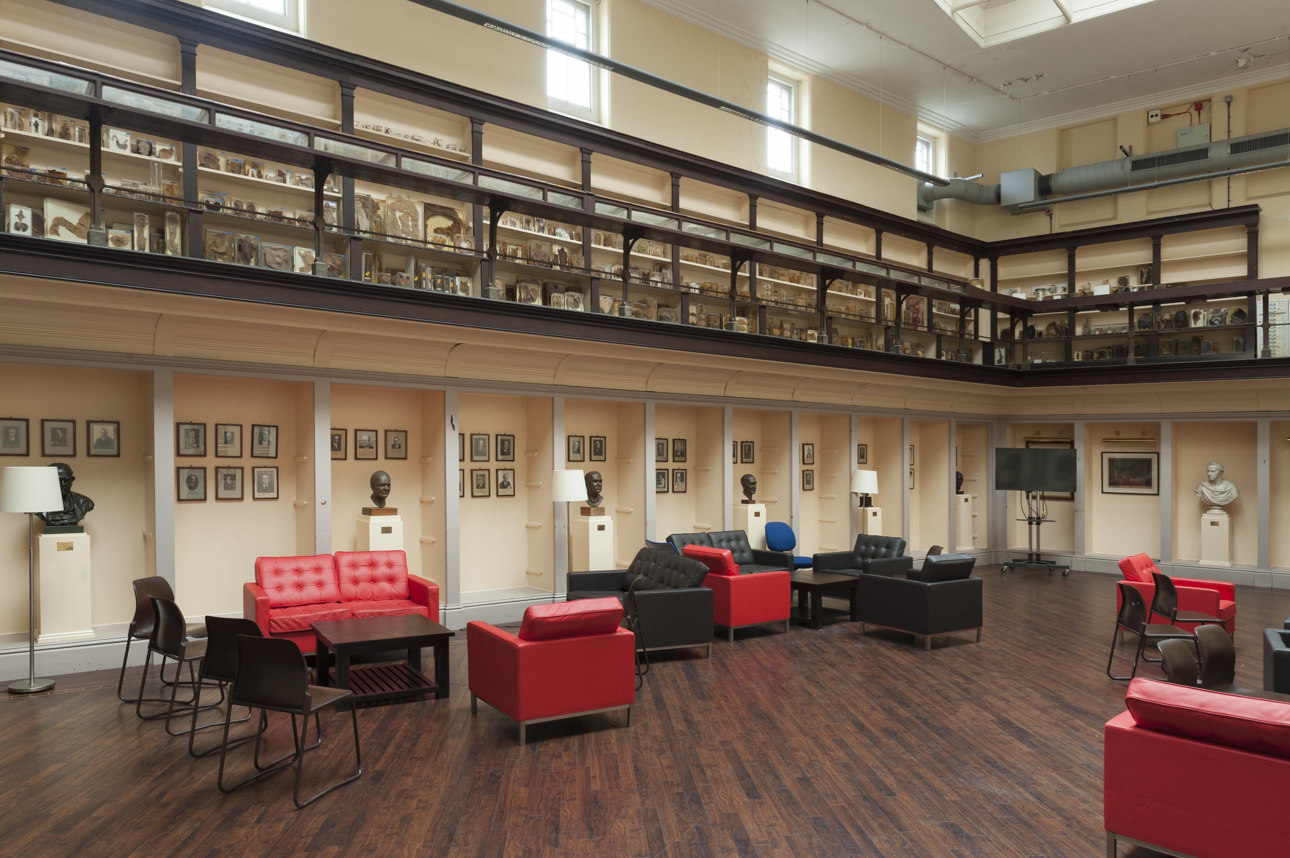
"title": "View of the former Anatomical Museum in the Garrod Building",
"author": {
"id": 27,
"username": "DerekKendall"
},
"feature": {
"id": 1189,
"type": "Feature",
"geometry": {
"type": "MultiPolygon",
"coordinates": [
[
[
[
-0.060957318414032,
51.51782190843071
],
[
-0.060536358742238,
51.517916494366496
],
[
-0.06042382559955,
51.5177169757099
],
[
-0.060423392052643,
51.517716267459285
],
[
-0.06037583590265,
51.51772558880798
],
[
-0.060352091559155,
51.517682266082666
],
[
-0.060399184829325,
51.5176714337657
],
[
-0.060382136461735,
51.517636775872596
],
[
-0.060366794729858,
51.51763667842599
],
[
-0.060353568375337,
51.517633521256826
],
[
-0.060340249107007,
51.51762886391949
],
[
-0.060331431296148,
51.51762072004323
],
[
-0.060328691457909,
51.51761554771857
],
[
-0.060326999079391,
51.517611443342886
],
[
-0.060327382221525,
51.517606284181284
],
[
-0.060329047985828,
51.51760203725169
],
[
-0.060331232366157,
51.517597910289986
],
[
-0.060333234968373,
51.517593887621835
],
[
-0.0603394749266,
51.51758477508556
],
[
-0.060343650894546,
51.51757832358151
],
[
-0.060315667444656,
51.51752195768432
],
[
-0.060339055445574,
51.51749626222509
],
[
-0.06039972958586,
51.51748509401273
],
[
-0.060844270778094,
51.51743888994093
],
[
-0.060875340433462,
51.517555246058656
],
[
-0.060894657489377,
51.517564918111205
],
[
-0.060905236784801,
51.51757830806902
],
[
-0.060907454524091,
51.51759005281749
],
[
-0.060906490522428,
51.51760128121761
],
[
-0.060896928755295,
51.51761642472545
],
[
-0.060890333226028,
51.51762687042926
],
[
-0.060957318414032,
51.51782190843071
]
]
]
]
},
"properties": {
"b_number": "",
"b_name": "Garrod Building",
"street": "Stepney Way",
"address": "Garrod Building",
"feature_type": "WHITECHAPEL_BUILDING",
"count": 31,
"search_str": "Garrod Building"
},
"tags": []
},
"file": "https://surveyoflondon.org/media/uploads/features/1189/SoL%20Whitechapel%20100529.jpg",
"description": "",
"copyright": true,
"created": "2017-03-09"
},
{
"id": 521,
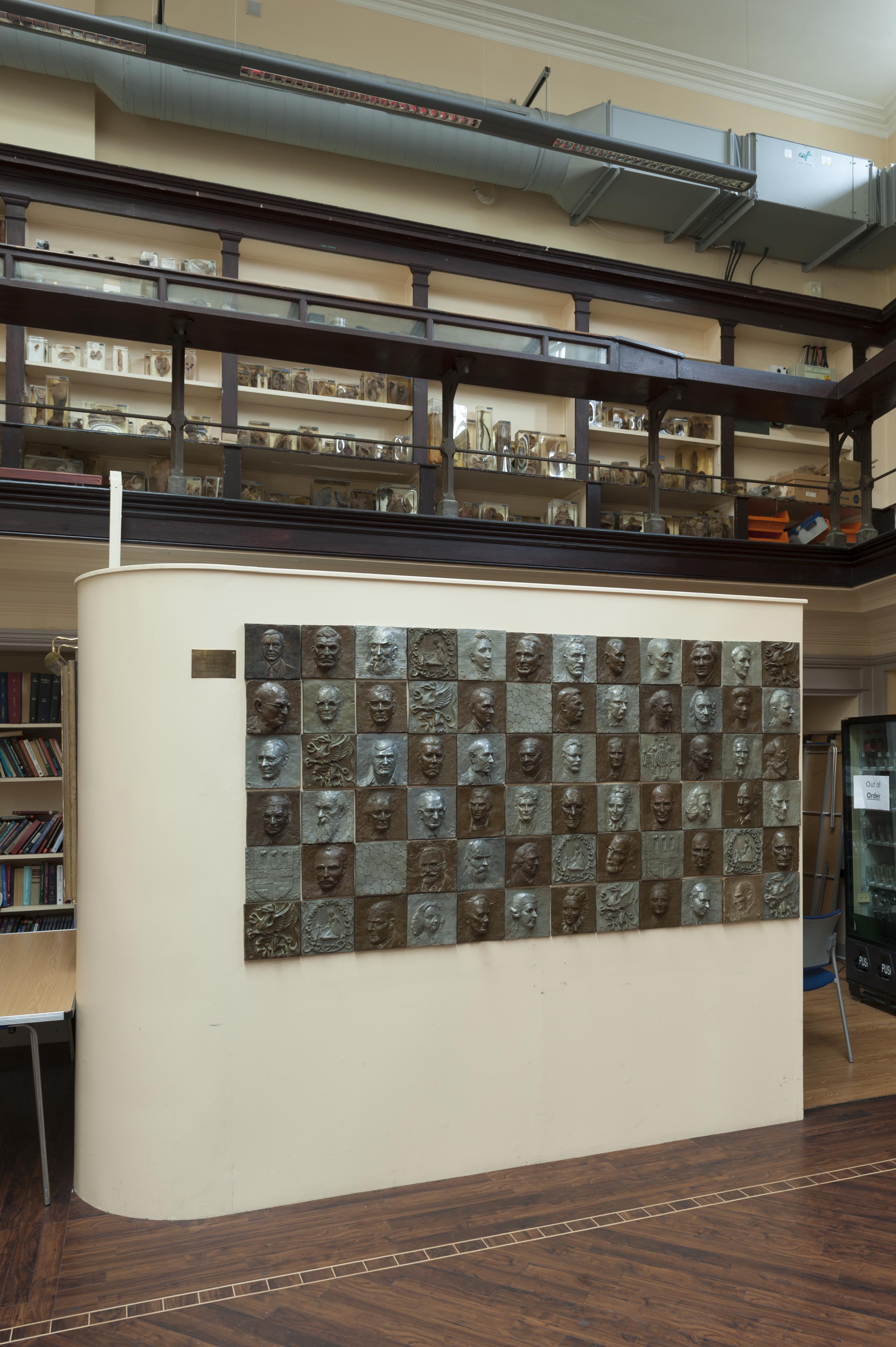
"title": "Mural in the former Anatomical Museum in the Garrod Building ",
"author": {
"id": 27,
"username": "DerekKendall"
},
"feature": {
"id": 1189,
"type": "Feature",
"geometry": {
"type": "MultiPolygon",
"coordinates": [
[
[
[
-0.060957318414032,
51.51782190843071
],
[
-0.060536358742238,
51.517916494366496
],
[
-0.06042382559955,
51.5177169757099
],
[
-0.060423392052643,
51.517716267459285
],
[
-0.06037583590265,
51.51772558880798
],
[
-0.060352091559155,
51.517682266082666
],
[
-0.060399184829325,
51.5176714337657
],
[
-0.060382136461735,
51.517636775872596
],
[
-0.060366794729858,
51.51763667842599
],
[
-0.060353568375337,
51.517633521256826
],
[
-0.060340249107007,
51.51762886391949
],
[
-0.060331431296148,
51.51762072004323
],
[
-0.060328691457909,
51.51761554771857
],
[
-0.060326999079391,
51.517611443342886
],
[
-0.060327382221525,
51.517606284181284
],
[
-0.060329047985828,
51.51760203725169
],
[
-0.060331232366157,
51.517597910289986
],
[
-0.060333234968373,
51.517593887621835
],
[
-0.0603394749266,
51.51758477508556
],
[
-0.060343650894546,
51.51757832358151
],
[
-0.060315667444656,
51.51752195768432
],
[
-0.060339055445574,
51.51749626222509
],
[
-0.06039972958586,
51.51748509401273
],
[
-0.060844270778094,
51.51743888994093
],
[
-0.060875340433462,
51.517555246058656
],
[
-0.060894657489377,
51.517564918111205
],
[
-0.060905236784801,
51.51757830806902
],
[
-0.060907454524091,
51.51759005281749
],
[
-0.060906490522428,
51.51760128121761
],
[
-0.060896928755295,
51.51761642472545
],
[
-0.060890333226028,
51.51762687042926
],
[
-0.060957318414032,
51.51782190843071
]
]
]
]
},
"properties": {
"b_number": "",
"b_name": "Garrod Building",
"street": "Stepney Way",
"address": "Garrod Building",
"feature_type": "WHITECHAPEL_BUILDING",
"count": 31,
"search_str": "Garrod Building"
},
"tags": []
},
"file": "https://surveyoflondon.org/media/uploads/features/1189/SoL%20Whitechapel%20100533.jpg",
"description": "Mural by John P. Blandy, Professor of Urology, presented to the Blizard Club c.1970",
"copyright": true,
"created": "2017-03-09"
},
{
"id": 655,
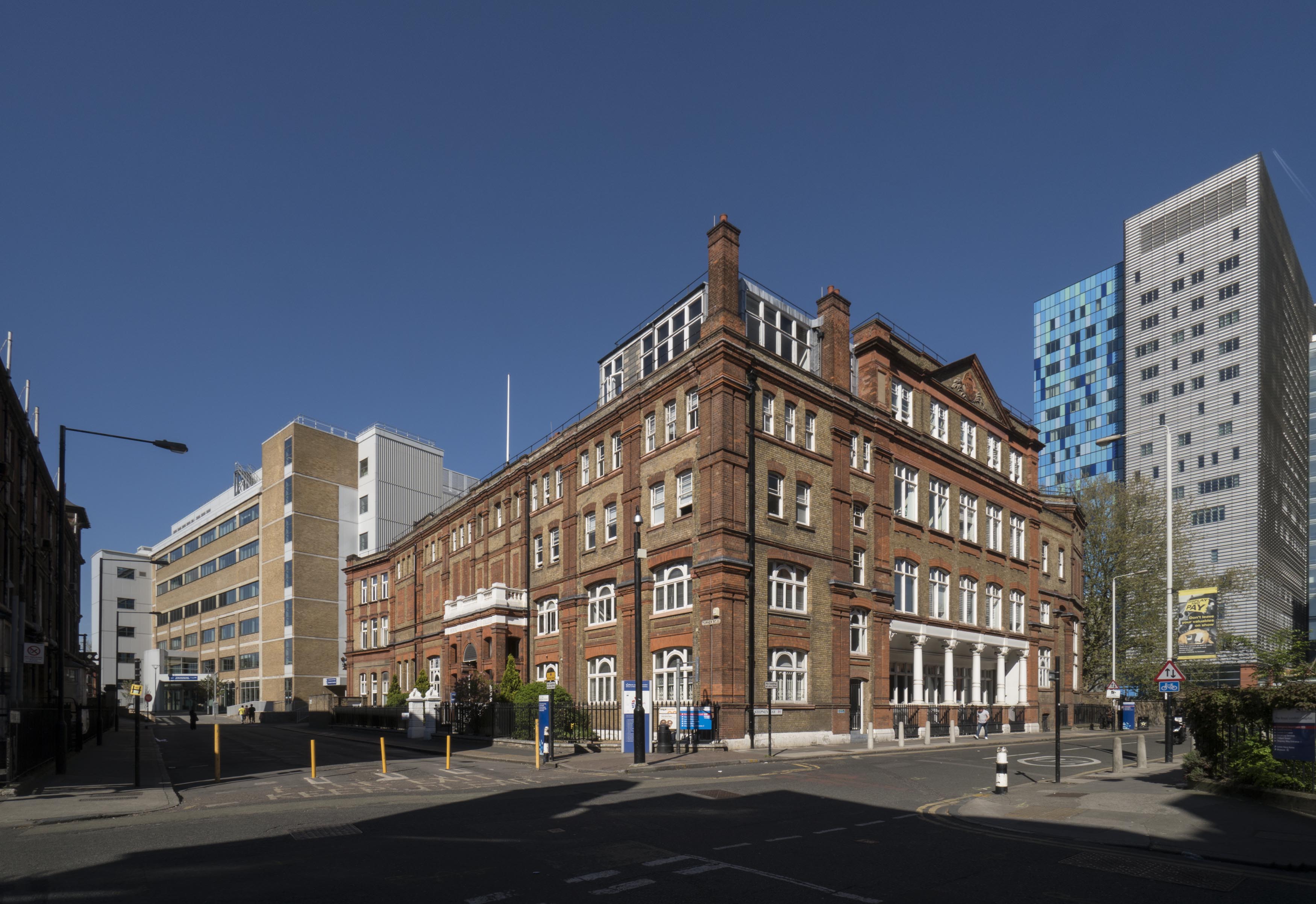
"title": "The Garrod Building and the Alexandra Wing of the Royal London Hospital from the south-west in 2017",
"author": {
"id": 27,
"username": "DerekKendall"
},
"feature": {
"id": 1189,
"type": "Feature",
"geometry": {
"type": "MultiPolygon",
"coordinates": [
[
[
[
-0.060957318414032,
51.51782190843071
],
[
-0.060536358742238,
51.517916494366496
],
[
-0.06042382559955,
51.5177169757099
],
[
-0.060423392052643,
51.517716267459285
],
[
-0.06037583590265,
51.51772558880798
],
[
-0.060352091559155,
51.517682266082666
],
[
-0.060399184829325,
51.5176714337657
],
[
-0.060382136461735,
51.517636775872596
],
[
-0.060366794729858,
51.51763667842599
],
[
-0.060353568375337,
51.517633521256826
],
[
-0.060340249107007,
51.51762886391949
],
[
-0.060331431296148,
51.51762072004323
],
[
-0.060328691457909,
51.51761554771857
],
[
-0.060326999079391,
51.517611443342886
],
[
-0.060327382221525,
51.517606284181284
],
[
-0.060329047985828,
51.51760203725169
],
[
-0.060331232366157,
51.517597910289986
],
[
-0.060333234968373,
51.517593887621835
],
[
-0.0603394749266,
51.51758477508556
],
[
-0.060343650894546,
51.51757832358151
],
[
-0.060315667444656,
51.51752195768432
],
[
-0.060339055445574,
51.51749626222509
],
[
-0.06039972958586,
51.51748509401273
],
[
-0.060844270778094,
51.51743888994093
],
[
-0.060875340433462,
51.517555246058656
],
[
-0.060894657489377,
51.517564918111205
],
[
-0.060905236784801,
51.51757830806902
],
[
-0.060907454524091,
51.51759005281749
],
[
-0.060906490522428,
51.51760128121761
],
[
-0.060896928755295,
51.51761642472545
],
[
-0.060890333226028,
51.51762687042926
],
[
-0.060957318414032,
51.51782190843071
]
]
]
]
},
"properties": {
"b_number": "",
"b_name": "Garrod Building",
"street": "Stepney Way",
"address": "Garrod Building",
"feature_type": "WHITECHAPEL_BUILDING",
"count": 31,
"search_str": "Garrod Building"
},
"tags": []
},
"file": "https://surveyoflondon.org/media/uploads/features/1189/SoL%20Whitechapel%20100541.jpg",
"description": "",
"copyright": true,
"created": "2017-05-09"
},
{
"id": 656,
"title": "The Garrod Building from the west, looking towards the Royal London Hospital in 2017",
"author": {
"id": 27,
"username": "DerekKendall"
},
"feature": {
"id": 1189,
"type": "Feature",
"geometry": {
"type": "MultiPolygon",
"coordinates": [
[
[
[
-0.060957318414032,
51.51782190843071
],
[
-0.060536358742238,
51.517916494366496
],
[
-0.06042382559955,
51.5177169757099
],
[
-0.060423392052643,
51.517716267459285
],
[
-0.06037583590265,
51.51772558880798
],
[
-0.060352091559155,
51.517682266082666
],
[
-0.060399184829325,
51.5176714337657
],
[
-0.060382136461735,
51.517636775872596
],
[
-0.060366794729858,
51.51763667842599
],
[
-0.060353568375337,
51.517633521256826
],
[
-0.060340249107007,
51.51762886391949
],
[
-0.060331431296148,
51.51762072004323
],
[
-0.060328691457909,
51.51761554771857
],
[
-0.060326999079391,
51.517611443342886
],
[
-0.060327382221525,
51.517606284181284
],
[
-0.060329047985828,
51.51760203725169
],
[
-0.060331232366157,
51.517597910289986
],
[
-0.060333234968373,
51.517593887621835
],
[
-0.0603394749266,
51.51758477508556
],
[
-0.060343650894546,
51.51757832358151
],
[
-0.060315667444656,
51.51752195768432
],
[
-0.060339055445574,
51.51749626222509
],
[
-0.06039972958586,
51.51748509401273
],
[
-0.060844270778094,
51.51743888994093
],
[
-0.060875340433462,
51.517555246058656
],
[
-0.060894657489377,
51.517564918111205
],
[
-0.060905236784801,
51.51757830806902
],
[
-0.060907454524091,
51.51759005281749
],
[
-0.060906490522428,
51.51760128121761
],
[
-0.060896928755295,
51.51761642472545
],
[
-0.060890333226028,
51.51762687042926
],
[
-0.060957318414032,
51.51782190843071
]
]
]
]
},
"properties": {
"b_number": "",
"b_name": "Garrod Building",
"street": "Stepney Way",
"address": "Garrod Building",
"feature_type": "WHITECHAPEL_BUILDING",
"count": 31,
"search_str": "Garrod Building"
},
"tags": []
},
"file": "https://surveyoflondon.org/media/uploads/features/1189/SoL%20Whitechapel%20100542.jpg",
"description": "",
"copyright": true,
"created": "2017-05-09"
},
{
"id": 662,
"title": "View of Turner Street in 2017, looking south towards St Philip's Church and the Good Samaritan public house",
"author": {
"id": 27,
"username": "DerekKendall"
},
"feature": {
"id": 1189,
"type": "Feature",
"geometry": {
"type": "MultiPolygon",
"coordinates": [
[
[
[
-0.060957318414032,
51.51782190843071
],
[
-0.060536358742238,
51.517916494366496
],
[
-0.06042382559955,
51.5177169757099
],
[
-0.060423392052643,
51.517716267459285
],
[
-0.06037583590265,
51.51772558880798
],
[
-0.060352091559155,
51.517682266082666
],
[
-0.060399184829325,
51.5176714337657
],
[
-0.060382136461735,
51.517636775872596
],
[
-0.060366794729858,
51.51763667842599
],
[
-0.060353568375337,
51.517633521256826
],
[
-0.060340249107007,
51.51762886391949
],
[
-0.060331431296148,
51.51762072004323
],
[
-0.060328691457909,
51.51761554771857
],
[
-0.060326999079391,
51.517611443342886
],
[
-0.060327382221525,
51.517606284181284
],
[
-0.060329047985828,
51.51760203725169
],
[
-0.060331232366157,
51.517597910289986
],
[
-0.060333234968373,
51.517593887621835
],
[
-0.0603394749266,
51.51758477508556
],
[
-0.060343650894546,
51.51757832358151
],
[
-0.060315667444656,
51.51752195768432
],
[
-0.060339055445574,
51.51749626222509
],
[
-0.06039972958586,
51.51748509401273
],
[
-0.060844270778094,
51.51743888994093
],
[
-0.060875340433462,
51.517555246058656
],
[
-0.060894657489377,
51.517564918111205
],
[
-0.060905236784801,
51.51757830806902
],
[
-0.060907454524091,
51.51759005281749
],
[
-0.060906490522428,
51.51760128121761
],
[
-0.060896928755295,
51.51761642472545
],
[
-0.060890333226028,
51.51762687042926
],
[
-0.060957318414032,
51.51782190843071
]
]
]
]
},
"properties": {
"b_number": "",
"b_name": "Garrod Building",
"street": "Stepney Way",
"address": "Garrod Building",
"feature_type": "WHITECHAPEL_BUILDING",
"count": 31,
"search_str": "Garrod Building"
},
"tags": []
},
"file": "https://surveyoflondon.org/media/uploads/features/1189/SoL%20Whitechapel%20100550.jpg",
"description": "",
"copyright": true,
"created": "2017-05-09"
},
{
"id": 1736,
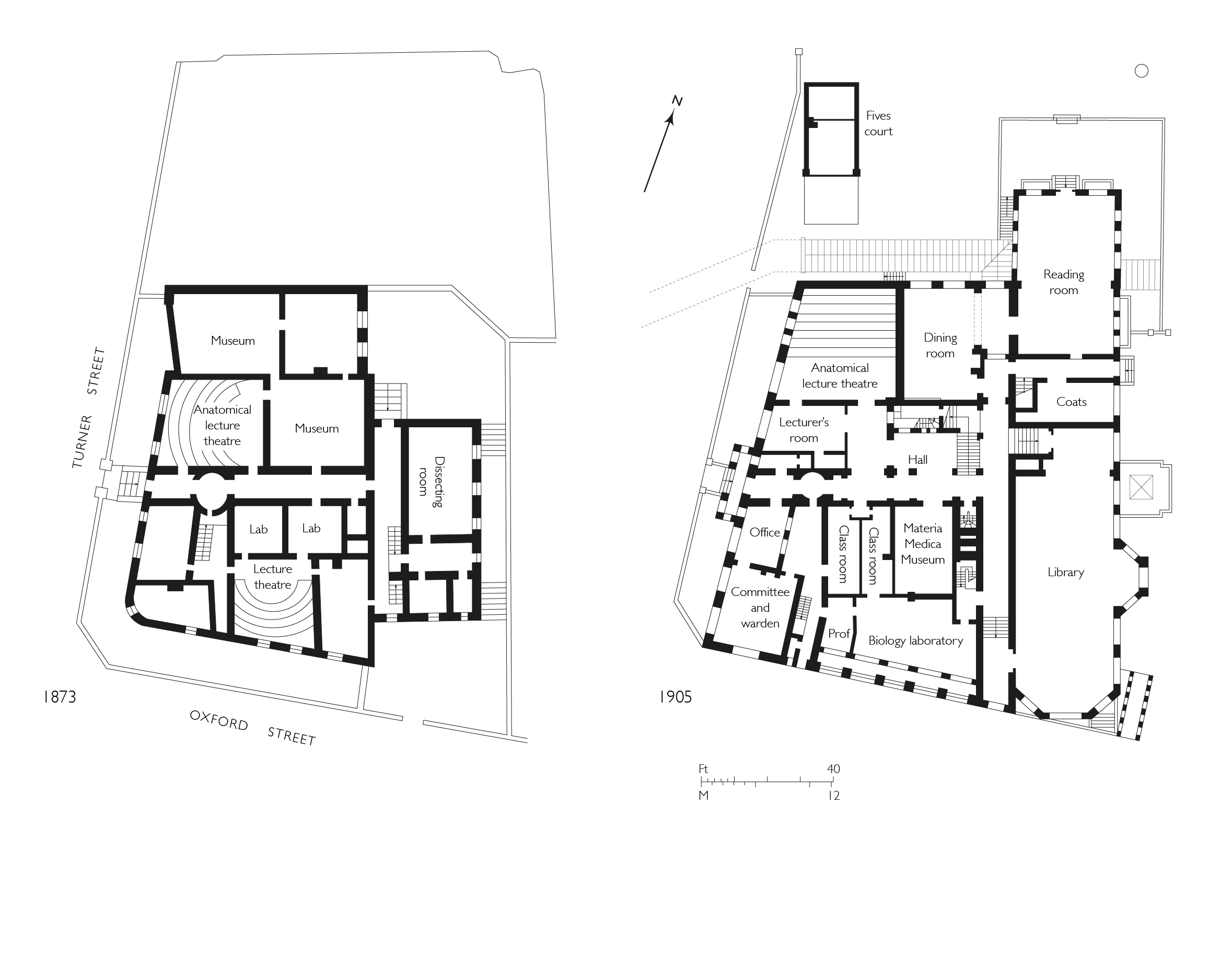
"title": "London Hospital Medical College, ground-floor plans in 1873 and 1905, drawing by Helen Jones",
"author": {
"id": 2,
"username": "surveyoflondon"
},
"feature": {
"id": 1189,
"type": "Feature",
"geometry": {
"type": "MultiPolygon",
"coordinates": [
[
[
[
-0.060957318414032,
51.51782190843071
],
[
-0.060536358742238,
51.517916494366496
],
[
-0.06042382559955,
51.5177169757099
],
[
-0.060423392052643,
51.517716267459285
],
[
-0.06037583590265,
51.51772558880798
],
[
-0.060352091559155,
51.517682266082666
],
[
-0.060399184829325,
51.5176714337657
],
[
-0.060382136461735,
51.517636775872596
],
[
-0.060366794729858,
51.51763667842599
],
[
-0.060353568375337,
51.517633521256826
],
[
-0.060340249107007,
51.51762886391949
],
[
-0.060331431296148,
51.51762072004323
],
[
-0.060328691457909,
51.51761554771857
],
[
-0.060326999079391,
51.517611443342886
],
[
-0.060327382221525,
51.517606284181284
],
[
-0.060329047985828,
51.51760203725169
],
[
-0.060331232366157,
51.517597910289986
],
[
-0.060333234968373,
51.517593887621835
],
[
-0.0603394749266,
51.51758477508556
],
[
-0.060343650894546,
51.51757832358151
],
[
-0.060315667444656,
51.51752195768432
],
[
-0.060339055445574,
51.51749626222509
],
[
-0.06039972958586,
51.51748509401273
],
[
-0.060844270778094,
51.51743888994093
],
[
-0.060875340433462,
51.517555246058656
],
[
-0.060894657489377,
51.517564918111205
],
[
-0.060905236784801,
51.51757830806902
],
[
-0.060907454524091,
51.51759005281749
],
[
-0.060906490522428,
51.51760128121761
],
[
-0.060896928755295,
51.51761642472545
],
[
-0.060890333226028,
51.51762687042926
],
[
-0.060957318414032,
51.51782190843071
]
]
]
]
},
"properties": {
"b_number": "",
"b_name": "Garrod Building",
"street": "Stepney Way",
"address": "Garrod Building",
"feature_type": "WHITECHAPEL_BUILDING",
"count": 31,
"search_str": "Garrod Building"
},
"tags": []
},
"file": "https://surveyoflondon.org/media/uploads/features/1189/Medical%20college%20Garrod%20Building%20latest.jpg",
"description": "",
"copyright": true,
"created": "2020-07-30"
},
{
"id": 1761,
"title": "1–54 Times Square from the north-west in 2017",
"author": {
"id": 27,
"username": "DerekKendall"
},
"feature": {
"id": 1007,
"type": "Feature",
"geometry": {
"type": "MultiPolygon",
"coordinates": [
[
[
[
-0.068604481747272,
51.51259519216751
],
[
-0.068394295073252,
51.512662674029954
],
[
-0.068193731130485,
51.51223927149179
],
[
-0.068417624655329,
51.51219797913798
],
[
-0.068604481747272,
51.51259519216751
]
]
]
]
},
"properties": {
"b_number": "1 to 54 ",
"b_name": "1–54 Times Square, Hooper Street",
"street": "Hooper Street",
"address": "1–54 Times Square",
"feature_type": "WHITECHAPEL_BUILDING",
"count": 10,
"search_str": "1–54 Times Square, Hooper Street"
},
"tags": []
},
"file": "https://surveyoflondon.org/media/uploads/features/1007/SoL%20Whitechapel%20101023.jpg",
"description": "",
"copyright": true,
"created": "2020-08-04"
},
{
"id": 1762,
"title": "Times Square from the west in 2017",
"author": {
"id": 27,
"username": "DerekKendall"
},
"feature": {
"id": 1007,
"type": "Feature",
"geometry": {
"type": "MultiPolygon",
"coordinates": [
[
[
[
-0.068604481747272,
51.51259519216751
],
[
-0.068394295073252,
51.512662674029954
],
[
-0.068193731130485,
51.51223927149179
],
[
-0.068417624655329,
51.51219797913798
],
[
-0.068604481747272,
51.51259519216751
]
]
]
]
},
"properties": {
"b_number": "1 to 54 ",
"b_name": "1–54 Times Square, Hooper Street",
"street": "Hooper Street",
"address": "1–54 Times Square",
"feature_type": "WHITECHAPEL_BUILDING",
"count": 10,
"search_str": "1–54 Times Square, Hooper Street"
},
"tags": []
},
"file": "https://surveyoflondon.org/media/uploads/features/1007/SoL%20Whitechapel%20101025.jpg",
"description": "",
"copyright": true,
"created": "2020-08-04"
},
{
"id": 1763,
"title": "1–54 Times Square and Christopher Court from the south in 2017",
"author": {
"id": 27,
"username": "DerekKendall"
},
"feature": {
"id": 1007,
"type": "Feature",
"geometry": {
"type": "MultiPolygon",
"coordinates": [
[
[
[
-0.068604481747272,
51.51259519216751
],
[
-0.068394295073252,
51.512662674029954
],
[
-0.068193731130485,
51.51223927149179
],
[
-0.068417624655329,
51.51219797913798
],
[
-0.068604481747272,
51.51259519216751
]
]
]
]
},
"properties": {
"b_number": "1 to 54 ",
"b_name": "1–54 Times Square, Hooper Street",
"street": "Hooper Street",
"address": "1–54 Times Square",
"feature_type": "WHITECHAPEL_BUILDING",
"count": 10,
"search_str": "1–54 Times Square, Hooper Street"
},
"tags": []
},
"file": "https://surveyoflondon.org/media/uploads/features/1007/SoL%20Whitechapel%20101027.jpg",
"description": "",
"copyright": true,
"created": "2020-08-04"
},
{
"id": 1764,
"title": "Times Square from the south-west in 2017",
"author": {
"id": 27,
"username": "DerekKendall"
},
"feature": {
"id": 1007,
"type": "Feature",
"geometry": {
"type": "MultiPolygon",
"coordinates": [
[
[
[
-0.068604481747272,
51.51259519216751
],
[
-0.068394295073252,
51.512662674029954
],
[
-0.068193731130485,
51.51223927149179
],
[
-0.068417624655329,
51.51219797913798
],
[
-0.068604481747272,
51.51259519216751
]
]
]
]
},
"properties": {
"b_number": "1 to 54 ",
"b_name": "1–54 Times Square, Hooper Street",
"street": "Hooper Street",
"address": "1–54 Times Square",
"feature_type": "WHITECHAPEL_BUILDING",
"count": 10,
"search_str": "1–54 Times Square, Hooper Street"
},
"tags": []
},
"file": "https://surveyoflondon.org/media/uploads/features/1007/SoL%20Whitechapel%20101029.jpg",
"description": "",
"copyright": true,
"created": "2020-08-04"
},
{
"id": 1817,
"title": "3 Gunthorpe Street from the south in 2021",
"author": {
"id": 27,
"username": "DerekKendall"
},
"feature": {
"id": 393,
"type": "Feature",
"geometry": {
"type": "MultiPolygon",
"coordinates": [
[
[
[
-0.071315563094337,
51.51642686515904
],
[
-0.071147761319042,
51.51648833942075
],
[
-0.070848700497228,
51.51617056685727
],
[
-0.071010815043599,
51.51611117624503
],
[
-0.071127640700614,
51.51624233423094
],
[
-0.071315563094337,
51.51642686515904
]
]
]
]
},
"properties": {
"b_number": "3",
"b_name": "3 Gunthorpe Street",
"street": "Gunthorpe Street",
"address": "3 Gunthorpe Street",
"feature_type": "WHITECHAPEL_BUILDING",
"count": 6,
"search_str": "3 Gunthorpe Street"
},
"tags": []
},
"file": "https://surveyoflondon.org/media/uploads/features/393/SoL%20Whitechapel%20102895.jpg",
"description": "",
"copyright": true,
"created": "2021-03-30"
},
{
"id": 1825,
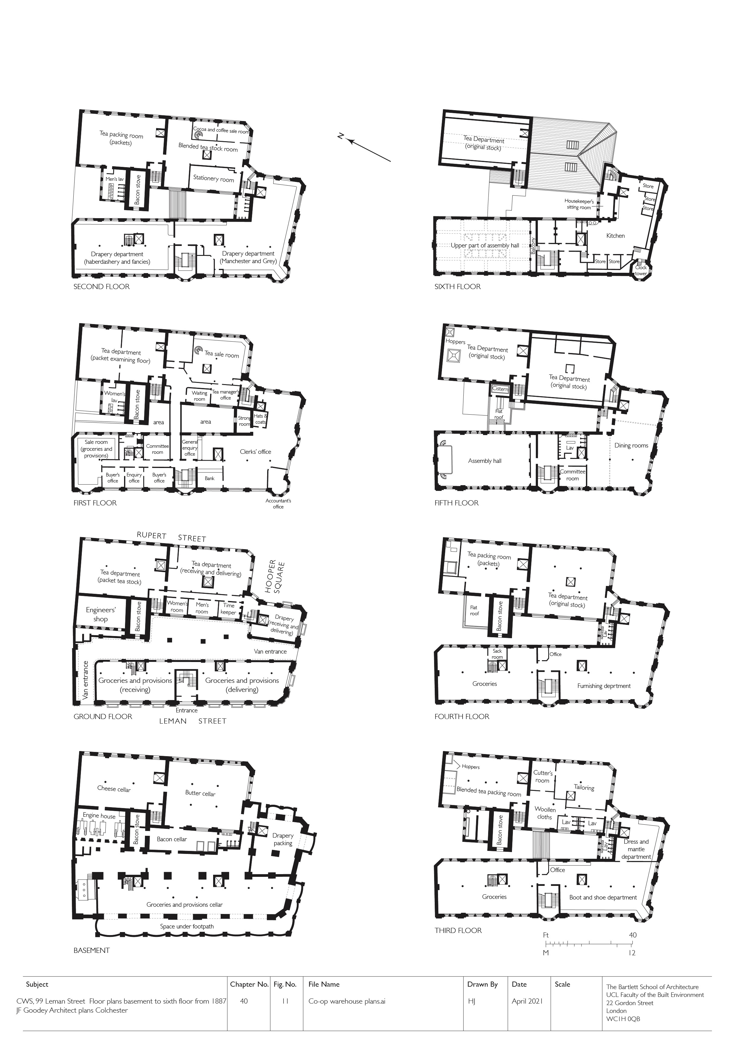
"title": "CWS Headquarters (now Sugar House), floor plans as built in 1887 (drawing by Helen Jones)",
"author": {
"id": 2,
"username": "surveyoflondon"
},
"feature": {
"id": 1264,
"type": "Feature",
"geometry": {
"type": "MultiPolygon",
"coordinates": [
[
[
[
-0.069331963951854,
51.51229594729769
],
[
-0.069137875560046,
51.512351392206085
],
[
-0.068952695054468,
51.51210160696183
],
[
-0.06877706008966,
51.51212449662561
],
[
-0.068766393531184,
51.5121102580591
],
[
-0.068775926288607,
51.51210689932468
],
[
-0.068782151200721,
51.51209293893689
],
[
-0.068742154431936,
51.5120172780914
],
[
-0.068763790231903,
51.51199419623458
],
[
-0.069027145444056,
51.51193993762725
],
[
-0.06905682792721,
51.51194862974888
],
[
-0.069331963951854,
51.51229594729769
]
]
]
]
},
"properties": {
"b_number": "99",
"b_name": "Sugar House, 99 Leman Street",
"street": "Leman Street",
"address": "Sugar House, 99 Leman Street",
"feature_type": "WHITECHAPEL_BUILDING",
"count": 21,
"search_str": "Sugar House, 99 Leman Street"
},
"tags": [
"Co-operative Wholesale Society"
]
},
"file": "https://surveyoflondon.org/media/uploads/features/1264/Co-op%20warehouse%20corrected.jpg",
"description": "",
"copyright": true,
"created": "2021-04-28"
},
{
"id": 1838,
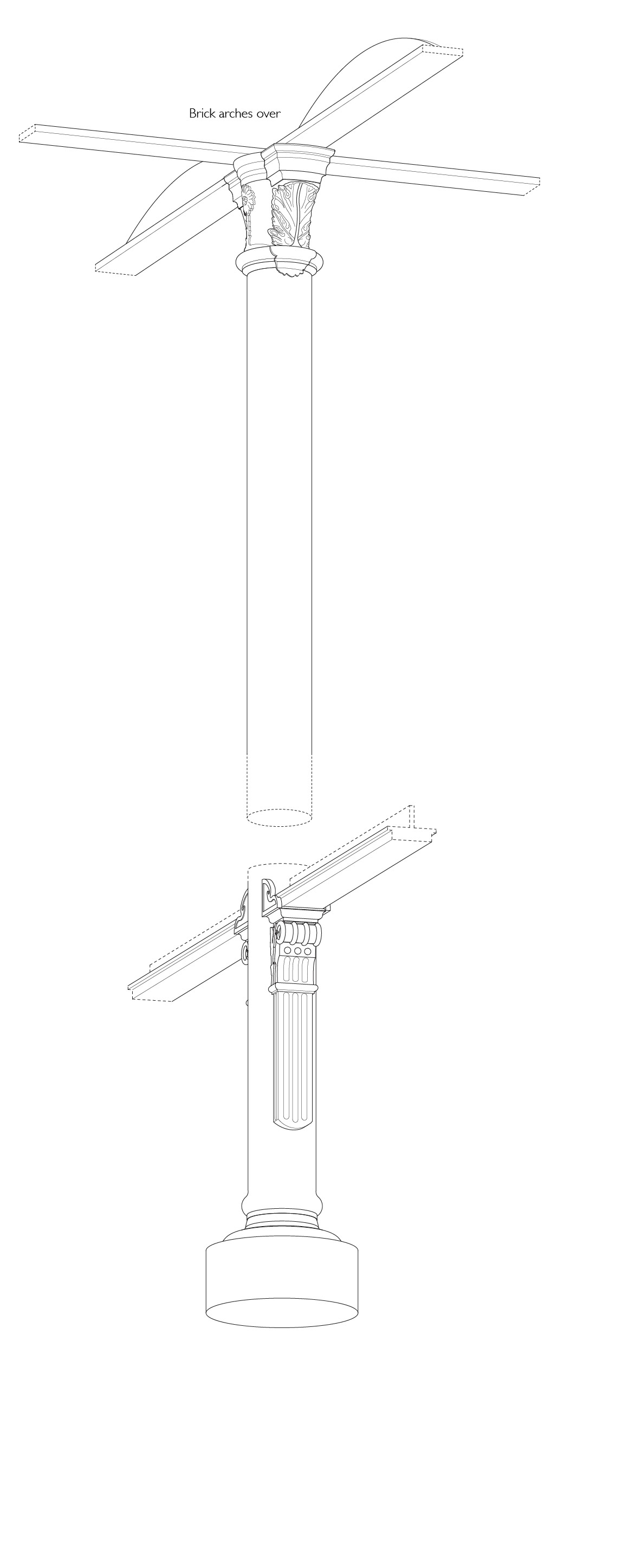
"title": "St George's Brewery, details of structural iron of 1846-7 at basement and ground-floor levels (measured and drawn, Helen Jones)",
"author": {
"id": 2,
"username": "surveyoflondon"
},
"feature": {
"id": 103,
"type": "Feature",
"geometry": {
"type": "MultiPolygon",
"coordinates": [
[
[
[
-0.068374712930605,
51.5151408298259
],
[
-0.06804295614913,
51.51523312333845
],
[
-0.067818209826392,
51.51529176188959
],
[
-0.067732324854293,
51.51515294140592
],
[
-0.068296249445127,
51.51502991558809
],
[
-0.068374712930605,
51.5151408298259
]
]
]
]
},
"properties": {
"b_number": "33",
"b_name": "",
"street": "Commercial Road",
"address": "Former St George's Brewery, 33 Commercial Road",
"feature_type": "WHITECHAPEL_BUILDING",
"count": 8,
"search_str": "Former St George's Brewery, 33 Commercial Road"
},
"tags": [
"brewery"
]
},
"file": "https://surveyoflondon.org/media/uploads/features/103/17.10%20HULT%20Both%20columns%203.jpg",
"description": "",
"copyright": true,
"created": "2021-05-04"
},
{
"id": 1690,
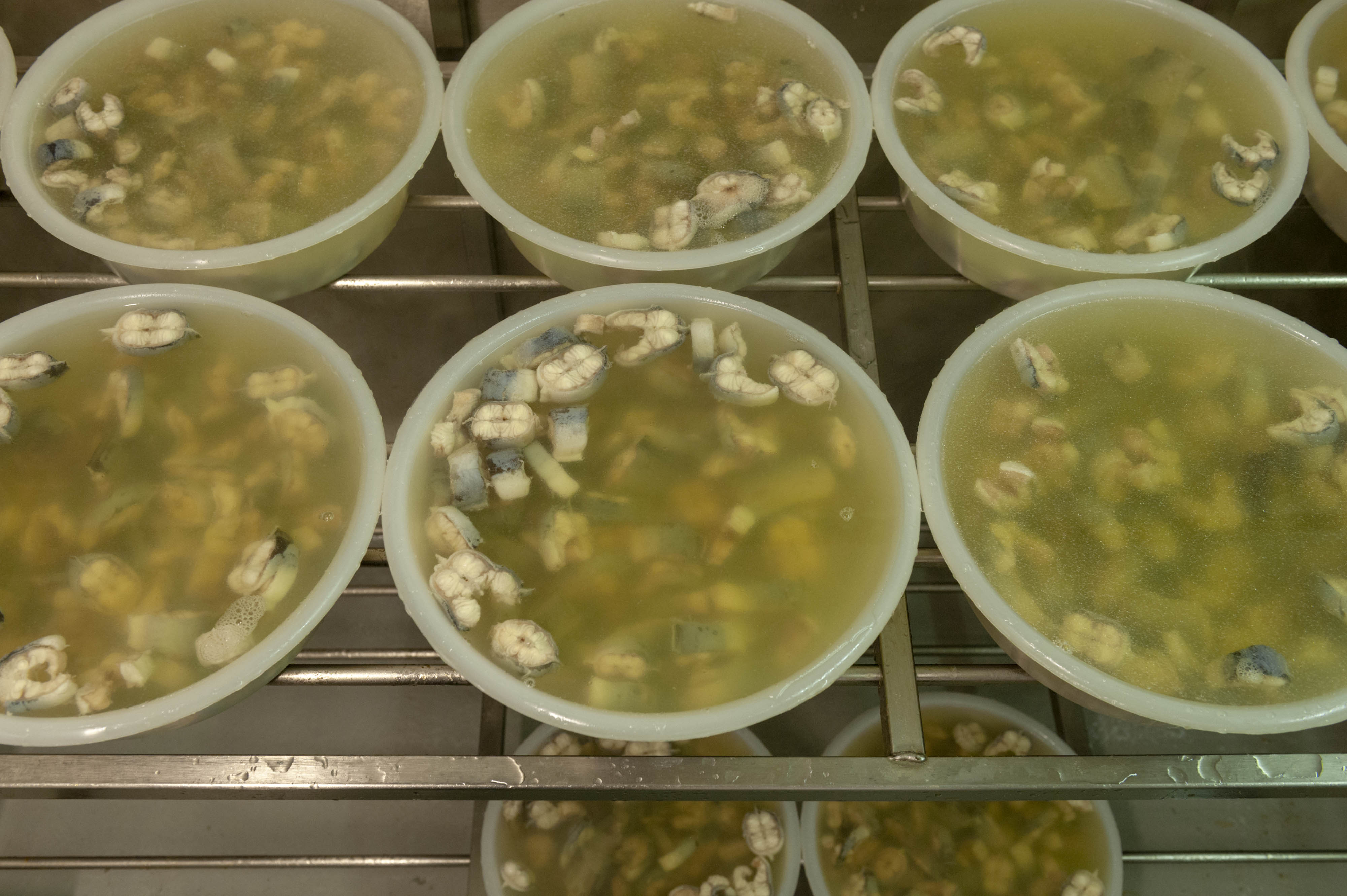
"title": "jellied eels",
"author": {
"id": 27,
"username": "DerekKendall"
},
"feature": {
"id": 1310,
"type": "Feature",
"geometry": {
"type": "MultiPolygon",
"coordinates": [
[
[
[
-0.072640543386628,
51.511126910908146
],
[
-0.072546284627394,
51.51109445750477
],
[
-0.072442870594844,
51.51105766937985
],
[
-0.072212891852196,
51.511015291752464
],
[
-0.071794996225884,
51.51092420910208
],
[
-0.072193476308503,
51.510898011530344
],
[
-0.072292806128645,
51.51091522504932
],
[
-0.072304530237151,
51.510931416638016
],
[
-0.07242778419924,
51.51096443737364
],
[
-0.072431087286307,
51.51095279556461
],
[
-0.072461272416322,
51.51095734673215
],
[
-0.072466091619938,
51.51096214778542
],
[
-0.072488635517089,
51.510966022410706
],
[
-0.072644665703862,
51.511088472040846
],
[
-0.072640543386628,
51.511126910908146
]
]
]
]
},
"properties": {
"b_number": "",
"b_name": "Railway Viaduct Spur",
"street": "Mansell Street / Chamber Street",
"address": "Railway Viaduct Spur, Mansell Street / Chamber Street",
"feature_type": "WHITECHAPEL_BUILDING",
"count": 17,
"search_str": "Railway Viaduct Spur"
},
"tags": []
},
"file": "https://surveyoflondon.org/media/uploads/features/1310/SoL%20Whitechapel%20102827.jpg",
"description": "",
"copyright": true,
"created": "2020-02-18"
},
{
"id": 1852,
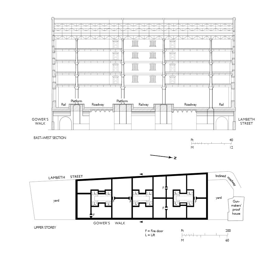
"title": "Commercial Road Goods Depot, east–west section and upper-storey plan, drawing by Helen Jones",
"author": {
"id": 2,
"username": "surveyoflondon"
},
"feature": {
"id": 1048,
"type": "Feature",
"geometry": {
"type": "MultiPolygon",
"coordinates": [
[
[
[
-0.069533901353918,
51.51425898768582
],
[
-0.068951227800474,
51.51452557120583
],
[
-0.068981900416026,
51.51455070932869
],
[
-0.0688166585981,
51.5146266832079
],
[
-0.068785386209583,
51.5146015041635
],
[
-0.068653255990076,
51.514661911269
],
[
-0.068508500301173,
51.51453712412918
],
[
-0.068473342844002,
51.514104588728905
],
[
-0.06844247211215,
51.514105667028474
],
[
-0.068432133336865,
51.51402775838509
],
[
-0.068465375478701,
51.51402504231887
],
[
-0.068458861292615,
51.51396650510224
],
[
-0.069020796129966,
51.51373596607887
],
[
-0.069533901353918,
51.51425898768582
]
]
]
]
},
"properties": {
"b_number": "",
"b_name": "Meranti House",
"street": "Alie Street",
"address": "Mernti House, Alie Street",
"feature_type": "WHITECHAPEL_BUILDING",
"count": 11,
"search_str": "Meranti House"
},
"tags": []
},
"file": "https://surveyoflondon.org/media/uploads/features/1048/Capture%20commercial%20road.JPG",
"description": "",
"copyright": true,
"created": "2021-08-17"
},
{
"id": 1707,
"title": "Dock Street and East Smithfield 1976",
"author": {
"id": 153,
"username": "danny"
},
"feature": {
"id": 1364,
"type": "Feature",
"geometry": {
"type": "MultiPolygon",
"coordinates": [
[
[
[
-0.068111447111593,
51.50952754577392
],
[
-0.06795711646976,
51.50918584981313
],
[
-0.068366784850446,
51.50910422814398
],
[
-0.06852193076641,
51.50944515016825
],
[
-0.068111447111593,
51.50952754577392
]
]
]
]
},
"properties": {
"b_number": "40",
"b_name": "",
"street": "Dock Street",
"address": "40 Dock Street",
"feature_type": "WHITECHAPEL_BUILDING",
"count": 6,
"search_str": "40 Dock Street"
},
"tags": [
"Vodafone"
]
},
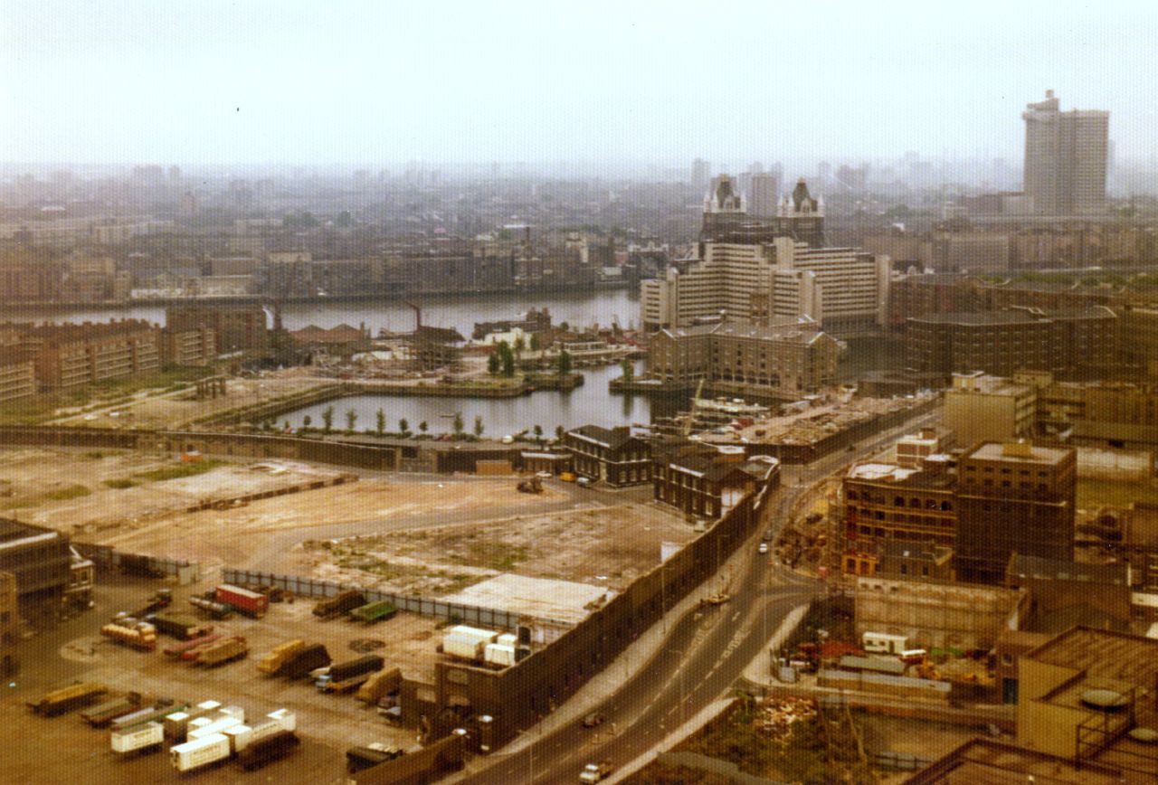
"file": "https://surveyoflondon.org/media/uploads/features/1364/Dock%20Street%20and%20East%20Smithfield%201976.jpg",
"description": "View towards Dock Street and East Smithfield from the top floor of Shearsmith House, Cable Street in 1976. Former Tea Warehouse close to bottom of Dock Street is visible - apparently built by Napoleonic War Prisoners. Also buildings along East Smithfield prior to the construction of the Royal Mint Estate.",
"copyright": false,
"created": "2020-05-12"
},
{
"id": 1490,
"title": "The Bell bottle-top decoration",
"author": {
"id": 27,
"username": "DerekKendall"
},
"feature": {
"id": 342,
"type": "Feature",
"geometry": {
"type": "MultiPolygon",
"coordinates": [
[
[
[
-0.075490206071596,
51.515861855458034
],
[
-0.075659057703334,
51.515761260447185
],
[
-0.075659062914062,
51.515761259453065
],
[
-0.075749282153509,
51.51581828564512
],
[
-0.075749034035063,
51.515842125205815
],
[
-0.075527961139716,
51.51590355994891
],
[
-0.075479038495002,
51.5158713869675
],
[
-0.075490214155051,
51.515861860567476
],
[
-0.075490206071596,
51.515861855458034
]
]
]
]
},
"properties": {
"b_number": "50",
"b_name": "The Bell, 50 Middlesex Street",
"street": "Middlesex Street",
"address": "The Bell, 50 Middlesex Street",
"feature_type": "WHITECHAPEL_BUILDING",
"count": 10,
"search_str": "The Bell, 50 Middlesex Street"
},
"tags": [
"house",
"public"
]
},
"file": "https://surveyoflondon.org/media/uploads/features/342/SoL%20Whitechapel%20100920.jpg",
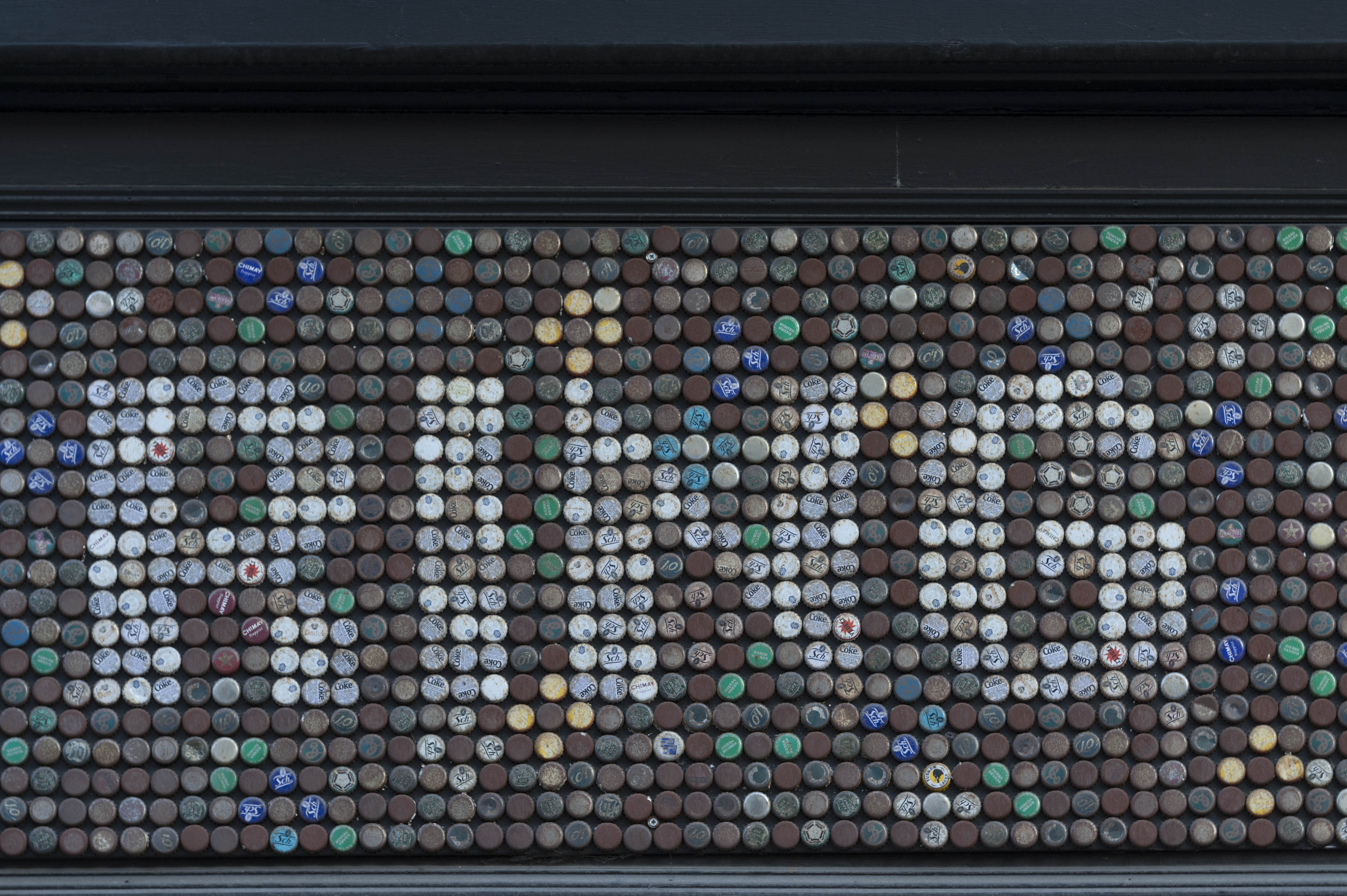
"description": "Decoration made from crown-cap bottle tops, part of a panel that reads 'YOU CAN RING MY DING DONG' that wraps around both frontages of The Bell, June 2017",
"copyright": true,
"created": "2019-01-07"
},
{
"id": 1738,
"title": "Central House from the north-west in July 2020",
"author": {
"id": 2,
"username": "surveyoflondon"
},
"feature": {
"id": 13,
"type": "Feature",
"geometry": {
"type": "MultiPolygon",
"coordinates": [
[
[
[
-0.070300598211778,
51.51553175369474
],
[
-0.069909685041584,
51.51566601870094
],
[
-0.069762598214758,
51.51551508304666
],
[
-0.06980073408505,
51.51550203175569
],
[
-0.069734850402611,
51.515430598241764
],
[
-0.0696935021834,
51.515445550776434
],
[
-0.069553336995274,
51.515279095645894
],
[
-0.069960309630875,
51.51513532543541
],
[
-0.070300598211778,
51.51553175369474
]
]
]
]
},
"properties": {
"b_number": "59-63",
"b_name": "Central House, London Metropolitan University",
"street": "Whitechapel High Street",
"address": "Central House, 59-63 Whitechapel High Street",
"feature_type": "WHITECHAPEL_BUILDING",
"count": 18,
"search_str": "Central House, London Metropolitan University"
},
"tags": []
},
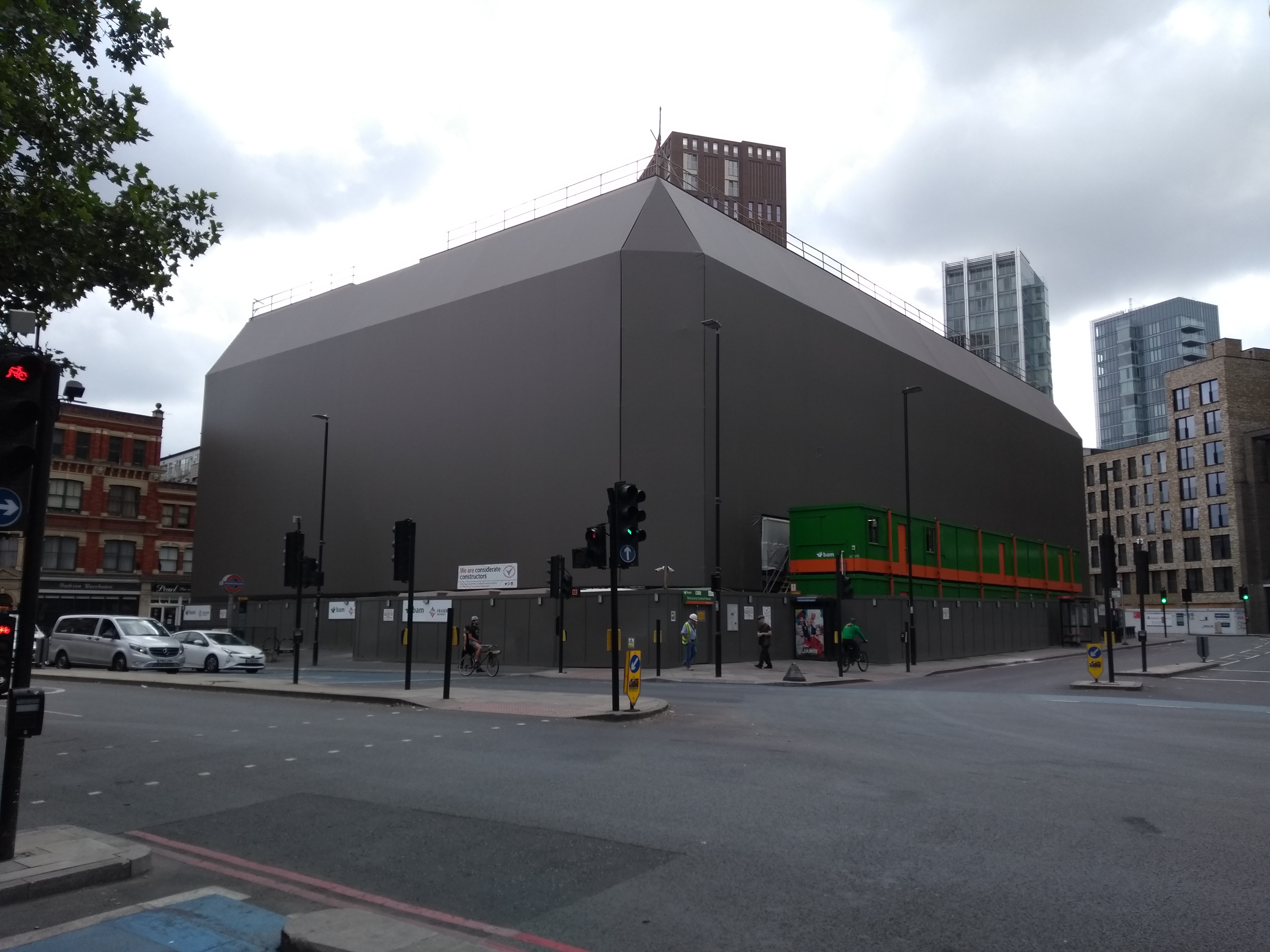
"file": "https://surveyoflondon.org/media/uploads/features/13/IMG_20200724_100952092.jpg",
"description": "",
"copyright": true,
"created": "2020-07-30"
},
{
"id": 753,
"title": "Looking north on John Fisher Street 1975",
"author": {
"id": 153,
"username": "danny"
},
"feature": {
"id": 1733,
"type": "Feature",
"geometry": {
"type": "MultiPolygon",
"coordinates": [
[
[
[
-0.068892751212955,
51.50914824642791
],
[
-0.068799946974016,
51.50916383923092
],
[
-0.068713036288349,
51.50896831153067
],
[
-0.068811057198783,
51.50895165738091
],
[
-0.068865405788081,
51.50907734033428
],
[
-0.068892751212955,
51.50914824642791
]
]
]
]
},
"properties": {
"b_number": "46-54",
"b_name": "",
"street": "John Fisher Street",
"address": "46-54 John Fisher Street on the Royal Mint Estate",
"feature_type": "WHITECHAPEL_BUILDING",
"count": 8,
"search_str": "46-54 John Fisher Street on the Royal Mint Estate"
},
"tags": []
},
"file": "https://surveyoflondon.org/media/uploads/features/1733/New%20Martan%20Street.jpg",
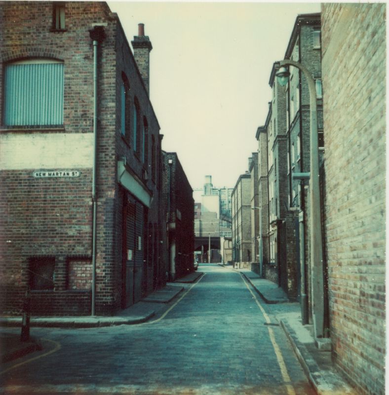
"description": "This is a picture taken in 1975 looking north along John Fisher Street just south of its junction with the former New Martan Street. This street was obliterated during the construction of the new Royal Mint Estate in the early 1980s. On the right, a high brick wall enclosed land that was colloquially known as Reece's Yard after the building contractor that had a yard for the storage of building materials there during the 1960s. Just south of where this picture was taken would have been offices used by the former government department the Property Services Agency (PSA) and the buiding known as the Monastery Tea Warehouse which occupied a site on land between John Fisher Street and Dock Street. It was demolished around this time. \n\nOn the left at the junction of New Martan Street was a former industrial building that had been left unoccupied and was a favourite play space of local kids (me included) who gained entry towards the back of the buildings. This was also demolished when the Royal Mint Estate was constructed. \n\nThe buildings of the Peabody Trust Whitechapel Estate can be seen running the rest of the length of John Fisher Street. First block on the right from the photo position is C block followed by B block and then L block. The last block visible towards the top of the street is A block. \n\nThe building just beyond the derelict industrial building on the left was the William Douger Tea Warehouse. Again demolished when the Royal Mint Estate was constructed. ",
"copyright": false,
"created": "2017-09-08"
}
]
}