HTTP 200 OK
Allow: GET, HEAD, OPTIONS
Content-Type: application/json
Vary: Accept
{
"count": 1747,
"next": "https://surveyoflondon.org/api/v1/images/?format=api&page=72",
"previous": "https://surveyoflondon.org/api/v1/images/?format=api&page=70",
"results": [
{
"id": 1673,
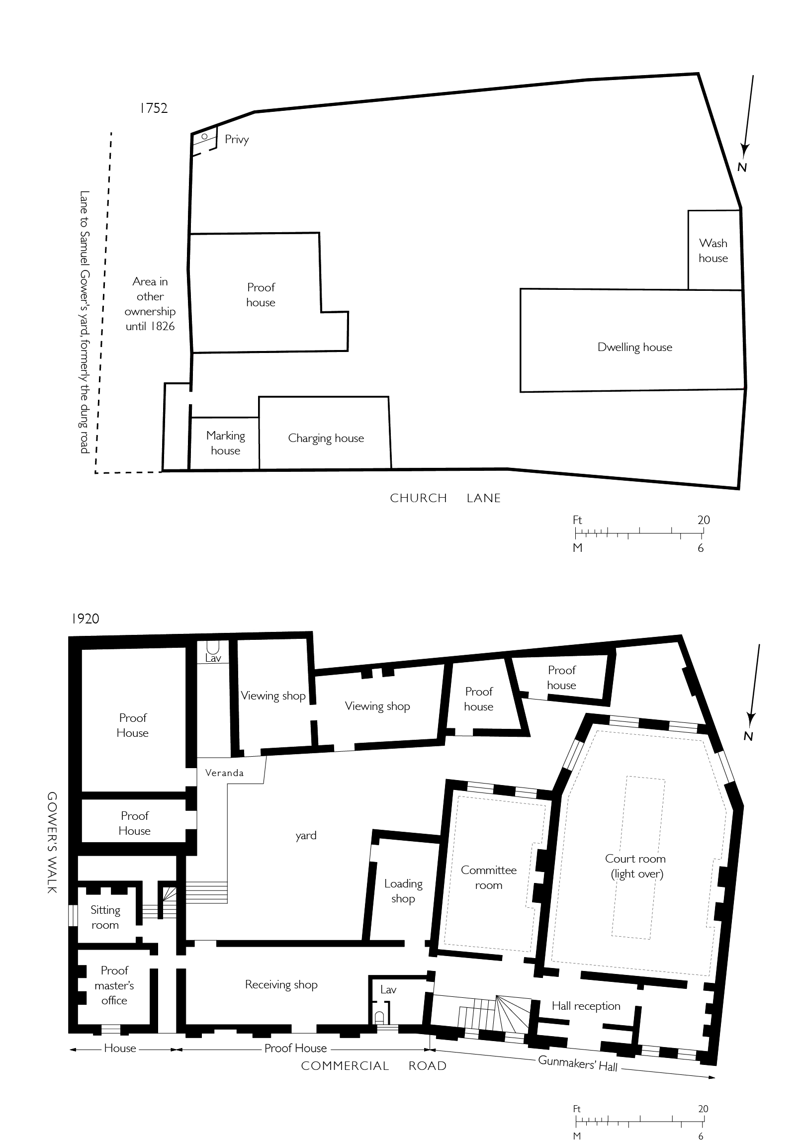
"title": "Gunmakers' Company's proof house complex, ground plans in 1752 and 1920",
"author": {
"id": 82,
"username": "HelenJones"
},
"feature": {
"id": 1016,
"type": "Feature",
"geometry": {
"type": "MultiPolygon",
"coordinates": [
[
[
[
-0.068260232398246,
51.51477078323367
],
[
-0.068015891167626,
51.5147824074063
],
[
-0.067989584029828,
51.514607222723676
],
[
-0.068165517221812,
51.5145962554253
],
[
-0.068167507270317,
51.51461124694583
],
[
-0.068237397616931,
51.5146070496752
],
[
-0.068260232398246,
51.51477078323367
]
],
[
[
-0.068202841801552,
51.51466683191732
],
[
-0.068136591673853,
51.51467046256953
],
[
-0.068144363769439,
51.51473136877517
],
[
-0.068208694296891,
51.51472806567735
],
[
-0.068202841801552,
51.51466683191732
]
],
[
[
-0.068088690886023,
51.514711682651345
],
[
-0.06808732190461,
51.51470153629181
],
[
-0.068009718204265,
51.51470567288329
],
[
-0.068011037313001,
51.51471548132591
],
[
-0.068088690886023,
51.514711682651345
]
]
]
]
},
"properties": {
"b_number": "48",
"b_name": "The Proof House, 48-50 Commercial Road",
"street": "Commercial Road",
"address": "Worshipful Company of Gunmakers, The Proof House, 48-50 Commercial Road",
"feature_type": "WHITECHAPEL_BUILDING",
"count": 15,
"search_str": "The Proof House, 48-50 Commercial Road"
},
"tags": []
},
"file": "https://surveyoflondon.org/media/uploads/features/1016/gummakers%201752%201920%20combined%20ammended%202.jpg",
"description": "",
"copyright": true,
"created": "2020-02-17"
},
{
"id": 1674,
"title": "Gunmakers' Company's receiving house and hall from the north-east in 2018",
"author": {
"id": 27,
"username": "DerekKendall"
},
"feature": {
"id": 1016,
"type": "Feature",
"geometry": {
"type": "MultiPolygon",
"coordinates": [
[
[
[
-0.068260232398246,
51.51477078323367
],
[
-0.068015891167626,
51.5147824074063
],
[
-0.067989584029828,
51.514607222723676
],
[
-0.068165517221812,
51.5145962554253
],
[
-0.068167507270317,
51.51461124694583
],
[
-0.068237397616931,
51.5146070496752
],
[
-0.068260232398246,
51.51477078323367
]
],
[
[
-0.068202841801552,
51.51466683191732
],
[
-0.068136591673853,
51.51467046256953
],
[
-0.068144363769439,
51.51473136877517
],
[
-0.068208694296891,
51.51472806567735
],
[
-0.068202841801552,
51.51466683191732
]
],
[
[
-0.068088690886023,
51.514711682651345
],
[
-0.06808732190461,
51.51470153629181
],
[
-0.068009718204265,
51.51470567288329
],
[
-0.068011037313001,
51.51471548132591
],
[
-0.068088690886023,
51.514711682651345
]
]
]
]
},
"properties": {
"b_number": "48",
"b_name": "The Proof House, 48-50 Commercial Road",
"street": "Commercial Road",
"address": "Worshipful Company of Gunmakers, The Proof House, 48-50 Commercial Road",
"feature_type": "WHITECHAPEL_BUILDING",
"count": 15,
"search_str": "The Proof House, 48-50 Commercial Road"
},
"tags": []
},
"file": "https://surveyoflondon.org/media/uploads/features/1016/SoL%20Whitechapel%20102467.jpg",
"description": "",
"copyright": true,
"created": "2020-02-17"
},
{
"id": 1675,
"title": "Gunmakers' Company's receiving house and proof-master's house from the north-west in 2018",
"author": {
"id": 27,
"username": "DerekKendall"
},
"feature": {
"id": 1016,
"type": "Feature",
"geometry": {
"type": "MultiPolygon",
"coordinates": [
[
[
[
-0.068260232398246,
51.51477078323367
],
[
-0.068015891167626,
51.5147824074063
],
[
-0.067989584029828,
51.514607222723676
],
[
-0.068165517221812,
51.5145962554253
],
[
-0.068167507270317,
51.51461124694583
],
[
-0.068237397616931,
51.5146070496752
],
[
-0.068260232398246,
51.51477078323367
]
],
[
[
-0.068202841801552,
51.51466683191732
],
[
-0.068136591673853,
51.51467046256953
],
[
-0.068144363769439,
51.51473136877517
],
[
-0.068208694296891,
51.51472806567735
],
[
-0.068202841801552,
51.51466683191732
]
],
[
[
-0.068088690886023,
51.514711682651345
],
[
-0.06808732190461,
51.51470153629181
],
[
-0.068009718204265,
51.51470567288329
],
[
-0.068011037313001,
51.51471548132591
],
[
-0.068088690886023,
51.514711682651345
]
]
]
]
},
"properties": {
"b_number": "48",
"b_name": "The Proof House, 48-50 Commercial Road",
"street": "Commercial Road",
"address": "Worshipful Company of Gunmakers, The Proof House, 48-50 Commercial Road",
"feature_type": "WHITECHAPEL_BUILDING",
"count": 15,
"search_str": "The Proof House, 48-50 Commercial Road"
},
"tags": []
},
"file": "https://surveyoflondon.org/media/uploads/features/1016/SoL%20Whitechapel%20102469.jpg",
"description": "",
"copyright": true,
"created": "2020-02-17"
},
{
"id": 1676,
"title": "Gunmakers' Company's proof house workshop on west side of internal courtyard from the north in 2018",
"author": {
"id": 27,
"username": "DerekKendall"
},
"feature": {
"id": 1016,
"type": "Feature",
"geometry": {
"type": "MultiPolygon",
"coordinates": [
[
[
[
-0.068260232398246,
51.51477078323367
],
[
-0.068015891167626,
51.5147824074063
],
[
-0.067989584029828,
51.514607222723676
],
[
-0.068165517221812,
51.5145962554253
],
[
-0.068167507270317,
51.51461124694583
],
[
-0.068237397616931,
51.5146070496752
],
[
-0.068260232398246,
51.51477078323367
]
],
[
[
-0.068202841801552,
51.51466683191732
],
[
-0.068136591673853,
51.51467046256953
],
[
-0.068144363769439,
51.51473136877517
],
[
-0.068208694296891,
51.51472806567735
],
[
-0.068202841801552,
51.51466683191732
]
],
[
[
-0.068088690886023,
51.514711682651345
],
[
-0.06808732190461,
51.51470153629181
],
[
-0.068009718204265,
51.51470567288329
],
[
-0.068011037313001,
51.51471548132591
],
[
-0.068088690886023,
51.514711682651345
]
]
]
]
},
"properties": {
"b_number": "48",
"b_name": "The Proof House, 48-50 Commercial Road",
"street": "Commercial Road",
"address": "Worshipful Company of Gunmakers, The Proof House, 48-50 Commercial Road",
"feature_type": "WHITECHAPEL_BUILDING",
"count": 15,
"search_str": "The Proof House, 48-50 Commercial Road"
},
"tags": []
},
"file": "https://surveyoflondon.org/media/uploads/features/1016/SoL%20Whitechapel%20102474.jpg",
"description": "",
"copyright": true,
"created": "2020-02-17"
},
{
"id": 434,
"title": "Fire at 54 Commercial Road, November 2003, from rear",
"author": {
"id": 68,
"username": "dcartwright"
},
"feature": {
"id": 996,
"type": "Feature",
"geometry": {
"type": "MultiPolygon",
"coordinates": [
[
[
[
-0.067861838065609,
51.51475347064
],
[
-0.06786453313317,
51.51478234806407
],
[
-0.067585581780586,
51.51476507543967
],
[
-0.067588509051496,
51.51474607517389
],
[
-0.067420739755857,
51.51473600887351
],
[
-0.067418669259981,
51.51475690079008
],
[
-0.067243977243653,
51.51474606363514
],
[
-0.067247831877495,
51.514720711350456
],
[
-0.067148423655411,
51.514715895823834
],
[
-0.067164508046975,
51.51459719968502
],
[
-0.067169468365816,
51.51455902742509
],
[
-0.067267424237092,
51.514565373164125
],
[
-0.067284203490366,
51.51446875999768
],
[
-0.067487888007954,
51.514480206746164
],
[
-0.067487831570817,
51.51448159696675
],
[
-0.067481262401076,
51.514514394275835
],
[
-0.067633797500801,
51.51452521712492
],
[
-0.067640049851402,
51.51449178362331
],
[
-0.067640050183764,
51.51449178093463
],
[
-0.067838967383754,
51.51450488151706
],
[
-0.067828248265366,
51.51461731190957
],
[
-0.067887142834602,
51.51462052176631
],
[
-0.06789972538097,
51.51475577751923
],
[
-0.067861838065609,
51.51475347064
]
]
]
]
},
"properties": {
"b_number": "52 to 58",
"b_name": "52 to 58 Commercial Road",
"street": "Commercial Road",
"address": "52 to 58 Commercial Road",
"feature_type": "WHITECHAPEL_BUILDING",
"count": 10,
"search_str": "52 to 58 Commercial Road"
},
"tags": []
},
"file": "https://surveyoflondon.org/media/uploads/features/996/fire.jpg",
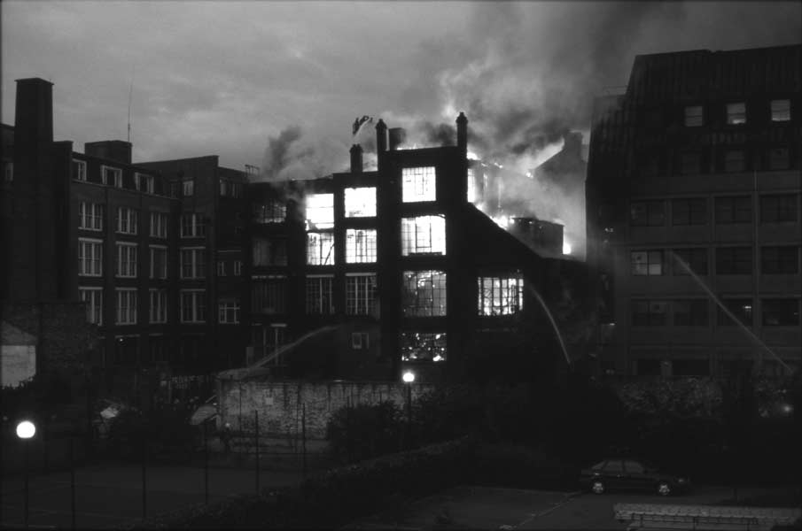
"description": "This fire gutted 54 Commercial Road (I believe that was the number of the central building). There was another fire a year or so later, and the building, along with its neighbour to the right in this photograph was demolished a few years later.",
"copyright": false,
"created": "2016-10-23"
},
{
"id": 642,
"title": "Mosque Tower from the north-west in April 2017",
"author": {
"id": 27,
"username": "DerekKendall"
},
"feature": {
"id": 836,
"type": "Feature",
"geometry": {
"type": "MultiPolygon",
"coordinates": [
[
[
[
-0.066520816994333,
51.517246214877474
],
[
-0.066489969268877,
51.51724714356767
],
[
-0.066417224734998,
51.51714569570538
],
[
-0.066368964847431,
51.517083010694115
],
[
-0.066362088087024,
51.51703424412635
],
[
-0.066488148658609,
51.516997483363426
],
[
-0.066518515364924,
51.51703801832892
],
[
-0.066585424403568,
51.51701850677438
],
[
-0.066680604125336,
51.51714555656476
],
[
-0.066613143364286,
51.51716783085946
],
[
-0.066640795978102,
51.51720613428293
],
[
-0.066520816994333,
51.517246214877474
]
]
]
]
},
"properties": {
"b_number": "1",
"b_name": "",
"street": "Fieldgate Street",
"address": "Mosque Tower, 1 Fieldgate Street and 36 Whitechapel Road",
"feature_type": "WHITECHAPEL_BUILDING",
"count": 4,
"search_str": "Mosque Tower, 1 Fieldgate Street and 36 Whitechapel Road"
},
"tags": []
},
"file": "https://surveyoflondon.org/media/uploads/features/836/SoL%20Whitechapel%20100740.jpg",
"description": "",
"copyright": true,
"created": "2017-05-03"
},
{
"id": 432,
"title": "52-58 Commercial Road, c. 2002",
"author": {
"id": 68,
"username": "dcartwright"
},
"feature": {
"id": 996,
"type": "Feature",
"geometry": {
"type": "MultiPolygon",
"coordinates": [
[
[
[
-0.067861838065609,
51.51475347064
],
[
-0.06786453313317,
51.51478234806407
],
[
-0.067585581780586,
51.51476507543967
],
[
-0.067588509051496,
51.51474607517389
],
[
-0.067420739755857,
51.51473600887351
],
[
-0.067418669259981,
51.51475690079008
],
[
-0.067243977243653,
51.51474606363514
],
[
-0.067247831877495,
51.514720711350456
],
[
-0.067148423655411,
51.514715895823834
],
[
-0.067164508046975,
51.51459719968502
],
[
-0.067169468365816,
51.51455902742509
],
[
-0.067267424237092,
51.514565373164125
],
[
-0.067284203490366,
51.51446875999768
],
[
-0.067487888007954,
51.514480206746164
],
[
-0.067487831570817,
51.51448159696675
],
[
-0.067481262401076,
51.514514394275835
],
[
-0.067633797500801,
51.51452521712492
],
[
-0.067640049851402,
51.51449178362331
],
[
-0.067640050183764,
51.51449178093463
],
[
-0.067838967383754,
51.51450488151706
],
[
-0.067828248265366,
51.51461731190957
],
[
-0.067887142834602,
51.51462052176631
],
[
-0.06789972538097,
51.51475577751923
],
[
-0.067861838065609,
51.51475347064
]
]
]
]
},
"properties": {
"b_number": "52 to 58",
"b_name": "52 to 58 Commercial Road",
"street": "Commercial Road",
"address": "52 to 58 Commercial Road",
"feature_type": "WHITECHAPEL_BUILDING",
"count": 10,
"search_str": "52 to 58 Commercial Road"
},
"tags": []
},
"file": "https://surveyoflondon.org/media/uploads/features/996/54CommercialRoadFront.jpg",
"description": "This shows the buildings on 52-58 Commercial Road, prior to their damage in a fire of November 2003, and eventual demolition several years later. It also shows a portion of the DSS (Department of Social Security) building at no. 60 which survived for longer but has now been replaced by \"Pure Aldgate\".",
"copyright": false,
"created": "2016-10-23"
},
{
"id": 1169,
"title": "The Blizard Building looking north in early 2018",
"author": {
"id": 27,
"username": "DerekKendall"
},
"feature": {
"id": 1163,
"type": "Feature",
"geometry": {
"type": "MultiPolygon",
"coordinates": [
[
[
[
-0.060979423312093,
51.51687996411422
],
[
-0.060821480072965,
51.516165829174554
],
[
-0.061150394642652,
51.5161342922288
],
[
-0.061250705098503,
51.51659420015728
],
[
-0.061483939056146,
51.516571247564805
],
[
-0.061372726955292,
51.51610718653116
],
[
-0.061473753012294,
51.516097396643715
],
[
-0.061545939688273,
51.51637602454029
],
[
-0.061578400286946,
51.51650000649485
],
[
-0.061813068160685,
51.5164781671439
],
[
-0.061841033599566,
51.51659920223576
],
[
-0.061917577172769,
51.51659314478618
],
[
-0.061935232261836,
51.516679987561794
],
[
-0.061860089281967,
51.51668593416029
],
[
-0.06188078856813,
51.51678775130236
],
[
-0.061650778364593,
51.51680797914597
],
[
-0.061652482216837,
51.51681638161555
],
[
-0.06154746554607,
51.51682671647673
],
[
-0.061489614276897,
51.51659788651982
],
[
-0.061258068758741,
51.516620672951085
],
[
-0.061315264564342,
51.51684691479345
],
[
-0.060979423312093,
51.51687996411422
]
]
]
]
},
"properties": {
"b_number": "",
"b_name": "",
"street": "Walden Street",
"address": "Blizard Building",
"feature_type": "WHITECHAPEL_BUILDING",
"count": 14,
"search_str": "Blizard Building"
},
"tags": []
},
"file": "https://surveyoflondon.org/media/uploads/features/1163/SoL%20Whitechapel%20101763.jpg",
"description": "",
"copyright": true,
"created": "2018-03-05"
},
{
"id": 1170,
"title": "The Blizard Building looking north-east in early 2018",
"author": {
"id": 27,
"username": "DerekKendall"
},
"feature": {
"id": 1163,
"type": "Feature",
"geometry": {
"type": "MultiPolygon",
"coordinates": [
[
[
[
-0.060979423312093,
51.51687996411422
],
[
-0.060821480072965,
51.516165829174554
],
[
-0.061150394642652,
51.5161342922288
],
[
-0.061250705098503,
51.51659420015728
],
[
-0.061483939056146,
51.516571247564805
],
[
-0.061372726955292,
51.51610718653116
],
[
-0.061473753012294,
51.516097396643715
],
[
-0.061545939688273,
51.51637602454029
],
[
-0.061578400286946,
51.51650000649485
],
[
-0.061813068160685,
51.5164781671439
],
[
-0.061841033599566,
51.51659920223576
],
[
-0.061917577172769,
51.51659314478618
],
[
-0.061935232261836,
51.516679987561794
],
[
-0.061860089281967,
51.51668593416029
],
[
-0.06188078856813,
51.51678775130236
],
[
-0.061650778364593,
51.51680797914597
],
[
-0.061652482216837,
51.51681638161555
],
[
-0.06154746554607,
51.51682671647673
],
[
-0.061489614276897,
51.51659788651982
],
[
-0.061258068758741,
51.516620672951085
],
[
-0.061315264564342,
51.51684691479345
],
[
-0.060979423312093,
51.51687996411422
]
]
]
]
},
"properties": {
"b_number": "",
"b_name": "",
"street": "Walden Street",
"address": "Blizard Building",
"feature_type": "WHITECHAPEL_BUILDING",
"count": 14,
"search_str": "Blizard Building"
},
"tags": []
},
"file": "https://surveyoflondon.org/media/uploads/features/1163/SoL%20Whitechapel%20101764.jpg",
"description": "",
"copyright": true,
"created": "2018-03-05"
},
{
"id": 1172,
"title": "The Blizard Building in early 2018, detail of west range",
"author": {
"id": 27,
"username": "DerekKendall"
},
"feature": {
"id": 1163,
"type": "Feature",
"geometry": {
"type": "MultiPolygon",
"coordinates": [
[
[
[
-0.060979423312093,
51.51687996411422
],
[
-0.060821480072965,
51.516165829174554
],
[
-0.061150394642652,
51.5161342922288
],
[
-0.061250705098503,
51.51659420015728
],
[
-0.061483939056146,
51.516571247564805
],
[
-0.061372726955292,
51.51610718653116
],
[
-0.061473753012294,
51.516097396643715
],
[
-0.061545939688273,
51.51637602454029
],
[
-0.061578400286946,
51.51650000649485
],
[
-0.061813068160685,
51.5164781671439
],
[
-0.061841033599566,
51.51659920223576
],
[
-0.061917577172769,
51.51659314478618
],
[
-0.061935232261836,
51.516679987561794
],
[
-0.061860089281967,
51.51668593416029
],
[
-0.06188078856813,
51.51678775130236
],
[
-0.061650778364593,
51.51680797914597
],
[
-0.061652482216837,
51.51681638161555
],
[
-0.06154746554607,
51.51682671647673
],
[
-0.061489614276897,
51.51659788651982
],
[
-0.061258068758741,
51.516620672951085
],
[
-0.061315264564342,
51.51684691479345
],
[
-0.060979423312093,
51.51687996411422
]
]
]
]
},
"properties": {
"b_number": "",
"b_name": "",
"street": "Walden Street",
"address": "Blizard Building",
"feature_type": "WHITECHAPEL_BUILDING",
"count": 14,
"search_str": "Blizard Building"
},
"tags": []
},
"file": "https://surveyoflondon.org/media/uploads/features/1163/SoL%20Whitechapel%20101771.jpg",
"description": "",
"copyright": true,
"created": "2018-03-05"
},
{
"id": 1173,
"title": "The Blizard Building in early 2018, looking south to Walden Street",
"author": {
"id": 27,
"username": "DerekKendall"
},
"feature": {
"id": 1163,
"type": "Feature",
"geometry": {
"type": "MultiPolygon",
"coordinates": [
[
[
[
-0.060979423312093,
51.51687996411422
],
[
-0.060821480072965,
51.516165829174554
],
[
-0.061150394642652,
51.5161342922288
],
[
-0.061250705098503,
51.51659420015728
],
[
-0.061483939056146,
51.516571247564805
],
[
-0.061372726955292,
51.51610718653116
],
[
-0.061473753012294,
51.516097396643715
],
[
-0.061545939688273,
51.51637602454029
],
[
-0.061578400286946,
51.51650000649485
],
[
-0.061813068160685,
51.5164781671439
],
[
-0.061841033599566,
51.51659920223576
],
[
-0.061917577172769,
51.51659314478618
],
[
-0.061935232261836,
51.516679987561794
],
[
-0.061860089281967,
51.51668593416029
],
[
-0.06188078856813,
51.51678775130236
],
[
-0.061650778364593,
51.51680797914597
],
[
-0.061652482216837,
51.51681638161555
],
[
-0.06154746554607,
51.51682671647673
],
[
-0.061489614276897,
51.51659788651982
],
[
-0.061258068758741,
51.516620672951085
],
[
-0.061315264564342,
51.51684691479345
],
[
-0.060979423312093,
51.51687996411422
]
]
]
]
},
"properties": {
"b_number": "",
"b_name": "",
"street": "Walden Street",
"address": "Blizard Building",
"feature_type": "WHITECHAPEL_BUILDING",
"count": 14,
"search_str": "Blizard Building"
},
"tags": []
},
"file": "https://surveyoflondon.org/media/uploads/features/1163/SoL%20Whitechapel%20101772.jpg",
"description": "",
"copyright": true,
"created": "2018-03-05"
},
{
"id": 1174,
"title": "The Blizard Building in early 2018, detail of east range",
"author": {
"id": 27,
"username": "DerekKendall"
},
"feature": {
"id": 1163,
"type": "Feature",
"geometry": {
"type": "MultiPolygon",
"coordinates": [
[
[
[
-0.060979423312093,
51.51687996411422
],
[
-0.060821480072965,
51.516165829174554
],
[
-0.061150394642652,
51.5161342922288
],
[
-0.061250705098503,
51.51659420015728
],
[
-0.061483939056146,
51.516571247564805
],
[
-0.061372726955292,
51.51610718653116
],
[
-0.061473753012294,
51.516097396643715
],
[
-0.061545939688273,
51.51637602454029
],
[
-0.061578400286946,
51.51650000649485
],
[
-0.061813068160685,
51.5164781671439
],
[
-0.061841033599566,
51.51659920223576
],
[
-0.061917577172769,
51.51659314478618
],
[
-0.061935232261836,
51.516679987561794
],
[
-0.061860089281967,
51.51668593416029
],
[
-0.06188078856813,
51.51678775130236
],
[
-0.061650778364593,
51.51680797914597
],
[
-0.061652482216837,
51.51681638161555
],
[
-0.06154746554607,
51.51682671647673
],
[
-0.061489614276897,
51.51659788651982
],
[
-0.061258068758741,
51.516620672951085
],
[
-0.061315264564342,
51.51684691479345
],
[
-0.060979423312093,
51.51687996411422
]
]
]
]
},
"properties": {
"b_number": "",
"b_name": "",
"street": "Walden Street",
"address": "Blizard Building",
"feature_type": "WHITECHAPEL_BUILDING",
"count": 14,
"search_str": "Blizard Building"
},
"tags": []
},
"file": "https://surveyoflondon.org/media/uploads/features/1163/SoL%20Whitechapel%20101773.jpg",
"description": "",
"copyright": true,
"created": "2018-03-05"
},
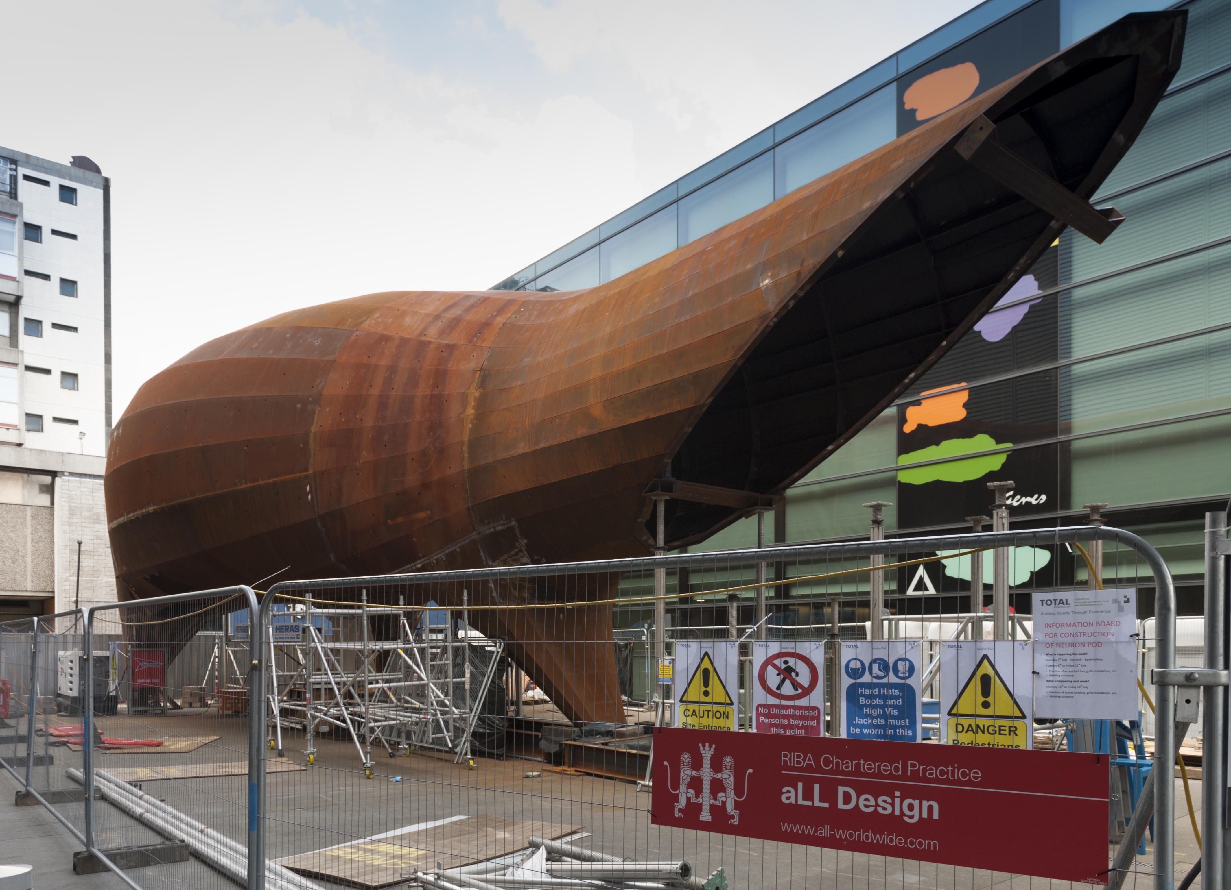
{
"id": 1261,
"title": "Neuron Pod in course of construction, May 2018",
"author": {
"id": 27,
"username": "DerekKendall"
},
"feature": {
"id": 1163,
"type": "Feature",
"geometry": {
"type": "MultiPolygon",
"coordinates": [
[
[
[
-0.060979423312093,
51.51687996411422
],
[
-0.060821480072965,
51.516165829174554
],
[
-0.061150394642652,
51.5161342922288
],
[
-0.061250705098503,
51.51659420015728
],
[
-0.061483939056146,
51.516571247564805
],
[
-0.061372726955292,
51.51610718653116
],
[
-0.061473753012294,
51.516097396643715
],
[
-0.061545939688273,
51.51637602454029
],
[
-0.061578400286946,
51.51650000649485
],
[
-0.061813068160685,
51.5164781671439
],
[
-0.061841033599566,
51.51659920223576
],
[
-0.061917577172769,
51.51659314478618
],
[
-0.061935232261836,
51.516679987561794
],
[
-0.061860089281967,
51.51668593416029
],
[
-0.06188078856813,
51.51678775130236
],
[
-0.061650778364593,
51.51680797914597
],
[
-0.061652482216837,
51.51681638161555
],
[
-0.06154746554607,
51.51682671647673
],
[
-0.061489614276897,
51.51659788651982
],
[
-0.061258068758741,
51.516620672951085
],
[
-0.061315264564342,
51.51684691479345
],
[
-0.060979423312093,
51.51687996411422
]
]
]
]
},
"properties": {
"b_number": "",
"b_name": "",
"street": "Walden Street",
"address": "Blizard Building",
"feature_type": "WHITECHAPEL_BUILDING",
"count": 14,
"search_str": "Blizard Building"
},
"tags": []
},
"file": "https://surveyoflondon.org/media/uploads/features/1163/SoL%20Whitechapel%20102016.jpg",
"description": "",
"copyright": true,
"created": "2018-05-29"
},
{
"id": 1292,
"title": "Neuron Pod under construction in 2018 (site notice)",
"author": {
"id": 27,
"username": "DerekKendall"
},
"feature": {
"id": 1163,
"type": "Feature",
"geometry": {
"type": "MultiPolygon",
"coordinates": [
[
[
[
-0.060979423312093,
51.51687996411422
],
[
-0.060821480072965,
51.516165829174554
],
[
-0.061150394642652,
51.5161342922288
],
[
-0.061250705098503,
51.51659420015728
],
[
-0.061483939056146,
51.516571247564805
],
[
-0.061372726955292,
51.51610718653116
],
[
-0.061473753012294,
51.516097396643715
],
[
-0.061545939688273,
51.51637602454029
],
[
-0.061578400286946,
51.51650000649485
],
[
-0.061813068160685,
51.5164781671439
],
[
-0.061841033599566,
51.51659920223576
],
[
-0.061917577172769,
51.51659314478618
],
[
-0.061935232261836,
51.516679987561794
],
[
-0.061860089281967,
51.51668593416029
],
[
-0.06188078856813,
51.51678775130236
],
[
-0.061650778364593,
51.51680797914597
],
[
-0.061652482216837,
51.51681638161555
],
[
-0.06154746554607,
51.51682671647673
],
[
-0.061489614276897,
51.51659788651982
],
[
-0.061258068758741,
51.516620672951085
],
[
-0.061315264564342,
51.51684691479345
],
[
-0.060979423312093,
51.51687996411422
]
]
]
]
},
"properties": {
"b_number": "",
"b_name": "",
"street": "Walden Street",
"address": "Blizard Building",
"feature_type": "WHITECHAPEL_BUILDING",
"count": 14,
"search_str": "Blizard Building"
},
"tags": []
},
"file": "https://surveyoflondon.org/media/uploads/features/1163/SoL%20Whitechapel%20102018.jpg",
"description": "",
"copyright": true,
"created": "2018-08-13"
},
{
"id": 1480,
"title": "Neuron Pod, December 2018, view from the north",
"author": {
"id": 27,
"username": "DerekKendall"
},
"feature": {
"id": 1163,
"type": "Feature",
"geometry": {
"type": "MultiPolygon",
"coordinates": [
[
[
[
-0.060979423312093,
51.51687996411422
],
[
-0.060821480072965,
51.516165829174554
],
[
-0.061150394642652,
51.5161342922288
],
[
-0.061250705098503,
51.51659420015728
],
[
-0.061483939056146,
51.516571247564805
],
[
-0.061372726955292,
51.51610718653116
],
[
-0.061473753012294,
51.516097396643715
],
[
-0.061545939688273,
51.51637602454029
],
[
-0.061578400286946,
51.51650000649485
],
[
-0.061813068160685,
51.5164781671439
],
[
-0.061841033599566,
51.51659920223576
],
[
-0.061917577172769,
51.51659314478618
],
[
-0.061935232261836,
51.516679987561794
],
[
-0.061860089281967,
51.51668593416029
],
[
-0.06188078856813,
51.51678775130236
],
[
-0.061650778364593,
51.51680797914597
],
[
-0.061652482216837,
51.51681638161555
],
[
-0.06154746554607,
51.51682671647673
],
[
-0.061489614276897,
51.51659788651982
],
[
-0.061258068758741,
51.516620672951085
],
[
-0.061315264564342,
51.51684691479345
],
[
-0.060979423312093,
51.51687996411422
]
]
]
]
},
"properties": {
"b_number": "",
"b_name": "",
"street": "Walden Street",
"address": "Blizard Building",
"feature_type": "WHITECHAPEL_BUILDING",
"count": 14,
"search_str": "Blizard Building"
},
"tags": []
},
"file": "https://surveyoflondon.org/media/uploads/features/1163/SoL%20Whitechapel%20102526.jpg",
"description": "",
"copyright": true,
"created": "2018-12-21"
},
{
"id": 1501,
"title": "Neuron Pod, December 2018, view from the northwest",
"author": {
"id": 27,
"username": "DerekKendall"
},
"feature": {
"id": 1163,
"type": "Feature",
"geometry": {
"type": "MultiPolygon",
"coordinates": [
[
[
[
-0.060979423312093,
51.51687996411422
],
[
-0.060821480072965,
51.516165829174554
],
[
-0.061150394642652,
51.5161342922288
],
[
-0.061250705098503,
51.51659420015728
],
[
-0.061483939056146,
51.516571247564805
],
[
-0.061372726955292,
51.51610718653116
],
[
-0.061473753012294,
51.516097396643715
],
[
-0.061545939688273,
51.51637602454029
],
[
-0.061578400286946,
51.51650000649485
],
[
-0.061813068160685,
51.5164781671439
],
[
-0.061841033599566,
51.51659920223576
],
[
-0.061917577172769,
51.51659314478618
],
[
-0.061935232261836,
51.516679987561794
],
[
-0.061860089281967,
51.51668593416029
],
[
-0.06188078856813,
51.51678775130236
],
[
-0.061650778364593,
51.51680797914597
],
[
-0.061652482216837,
51.51681638161555
],
[
-0.06154746554607,
51.51682671647673
],
[
-0.061489614276897,
51.51659788651982
],
[
-0.061258068758741,
51.516620672951085
],
[
-0.061315264564342,
51.51684691479345
],
[
-0.060979423312093,
51.51687996411422
]
]
]
]
},
"properties": {
"b_number": "",
"b_name": "",
"street": "Walden Street",
"address": "Blizard Building",
"feature_type": "WHITECHAPEL_BUILDING",
"count": 14,
"search_str": "Blizard Building"
},
"tags": []
},
"file": "https://surveyoflondon.org/media/uploads/features/1163/SoL%20Whitechapel%20102524.jpg",
"description": "",
"copyright": true,
"created": "2019-01-09"
},
{
"id": 1502,
"title": "Neuron Pod, December 2018, view from the southwest",
"author": {
"id": 27,
"username": "DerekKendall"
},
"feature": {
"id": 1163,
"type": "Feature",
"geometry": {
"type": "MultiPolygon",
"coordinates": [
[
[
[
-0.060979423312093,
51.51687996411422
],
[
-0.060821480072965,
51.516165829174554
],
[
-0.061150394642652,
51.5161342922288
],
[
-0.061250705098503,
51.51659420015728
],
[
-0.061483939056146,
51.516571247564805
],
[
-0.061372726955292,
51.51610718653116
],
[
-0.061473753012294,
51.516097396643715
],
[
-0.061545939688273,
51.51637602454029
],
[
-0.061578400286946,
51.51650000649485
],
[
-0.061813068160685,
51.5164781671439
],
[
-0.061841033599566,
51.51659920223576
],
[
-0.061917577172769,
51.51659314478618
],
[
-0.061935232261836,
51.516679987561794
],
[
-0.061860089281967,
51.51668593416029
],
[
-0.06188078856813,
51.51678775130236
],
[
-0.061650778364593,
51.51680797914597
],
[
-0.061652482216837,
51.51681638161555
],
[
-0.06154746554607,
51.51682671647673
],
[
-0.061489614276897,
51.51659788651982
],
[
-0.061258068758741,
51.516620672951085
],
[
-0.061315264564342,
51.51684691479345
],
[
-0.060979423312093,
51.51687996411422
]
]
]
]
},
"properties": {
"b_number": "",
"b_name": "",
"street": "Walden Street",
"address": "Blizard Building",
"feature_type": "WHITECHAPEL_BUILDING",
"count": 14,
"search_str": "Blizard Building"
},
"tags": []
},
"file": "https://surveyoflondon.org/media/uploads/features/1163/SoL%20Whitechapel%20102537.jpg",
"description": "",
"copyright": true,
"created": "2019-01-09"
},
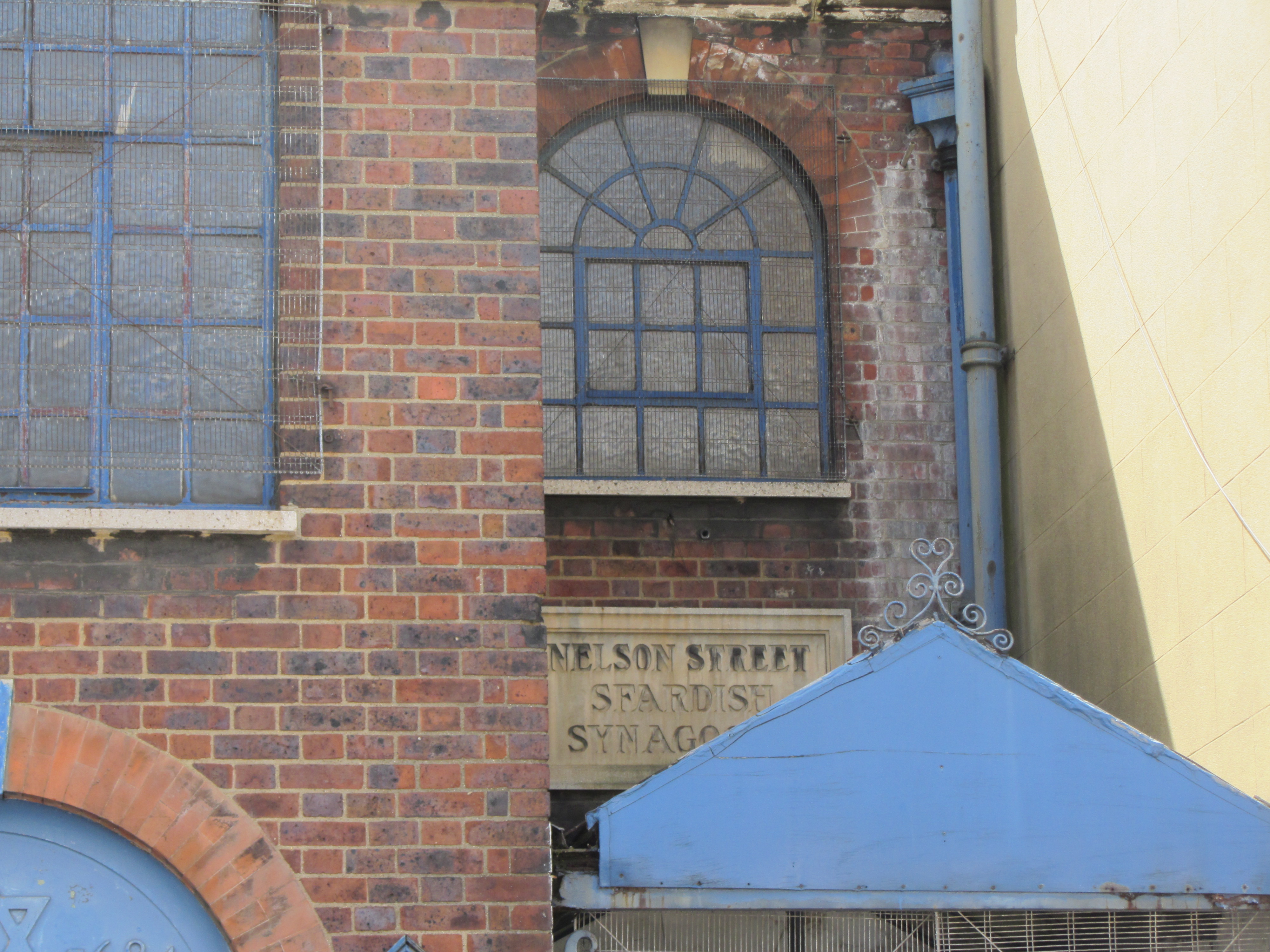
{
"id": 124,
"title": "View of plaque on the north elevation of the East London Central Synagogue",
"author": {
"id": 11,
"username": "amyspencer"
},
"feature": {
"id": 1223,
"type": "Feature",
"geometry": {
"type": "MultiPolygon",
"coordinates": [
[
[
[
-0.060006488271847,
51.51510627570232
],
[
-0.060013828479506,
51.51514108634351
],
[
-0.060041191538188,
51.51513847488316
],
[
-0.060044966435695,
51.51515486133312
],
[
-0.060046280894631,
51.515160267115604
],
[
-0.06006361028193,
51.51523153503032
],
[
-0.060038376114045,
51.515234772078884
],
[
-0.060045827749183,
51.515261090649105
],
[
-0.060015205701946,
51.5152645036895
],
[
-0.060016148787444,
51.515268254903
],
[
-0.059983698589757,
51.51527136600084
],
[
-0.059982800623722,
51.51526769635853
],
[
-0.05980489998415,
51.51528464054933
],
[
-0.059795138699586,
51.515241962297075
],
[
-0.059761324311277,
51.51524516305319
],
[
-0.059744612932379,
51.51517643483414
],
[
-0.059778381606491,
51.51517323840473
],
[
-0.059769223543847,
51.515128898143736
],
[
-0.060006488271847,
51.51510627570232
]
]
]
]
},
"properties": {
"b_number": "30-40",
"b_name": "",
"street": "Nelson Street",
"address": "East London Central Synagogue",
"feature_type": "WHITECHAPEL_BUILDING",
"count": 3,
"search_str": "East London Central Synagogue"
},
"tags": []
},
"file": "https://surveyoflondon.org/media/uploads/features/1223/IMG_8293.JPG",
"description": "",
"copyright": false,
"created": "2016-07-13"
},
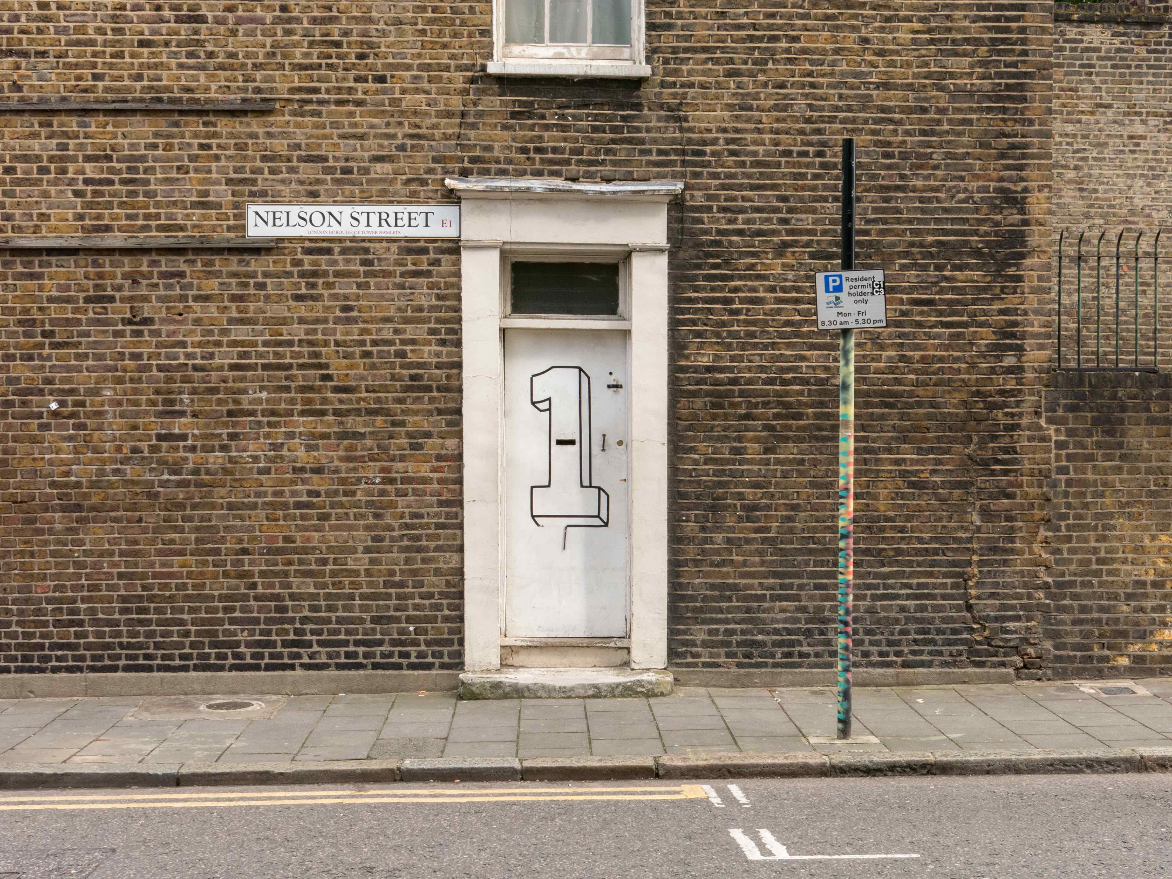
{
"id": 751,
"title": "Front door of 1 Nelson Street in May 2014",
"author": {
"id": 18,
"username": "shahedsaleem"
},
"feature": {
"id": 1138,
"type": "Feature",
"geometry": {
"type": "MultiPolygon",
"coordinates": [
[
[
[
-0.061913247200568,
51.515258190700564
],
[
-0.061803683307523,
51.515267144215876
],
[
-0.061793634541946,
51.515216333855264
],
[
-0.061902697869782,
51.515207937041524
],
[
-0.061913247200568,
51.515258190700564
]
]
]
]
},
"properties": {
"b_number": "8",
"b_name": "",
"street": "New Road",
"address": "8 New Road",
"feature_type": "WHITECHAPEL_BUILDING",
"count": 2,
"search_str": "8 New Road"
},
"tags": []
},
"file": "https://surveyoflondon.org/media/uploads/features/1138/20140522-IMG_0055%20copy.jpg",
"description": "The entrance to No.1 Nelson Street is on the side wall of No.8 New Road, so I wonder if no one could ever find it, hence the graphics.\nIn 2016 Listed Building Consent was approved for No.1 Nelson St to repair the elevations and replace the windows like for like, so I wonder if this door survived.",
"copyright": false,
"created": "2017-09-06"
},
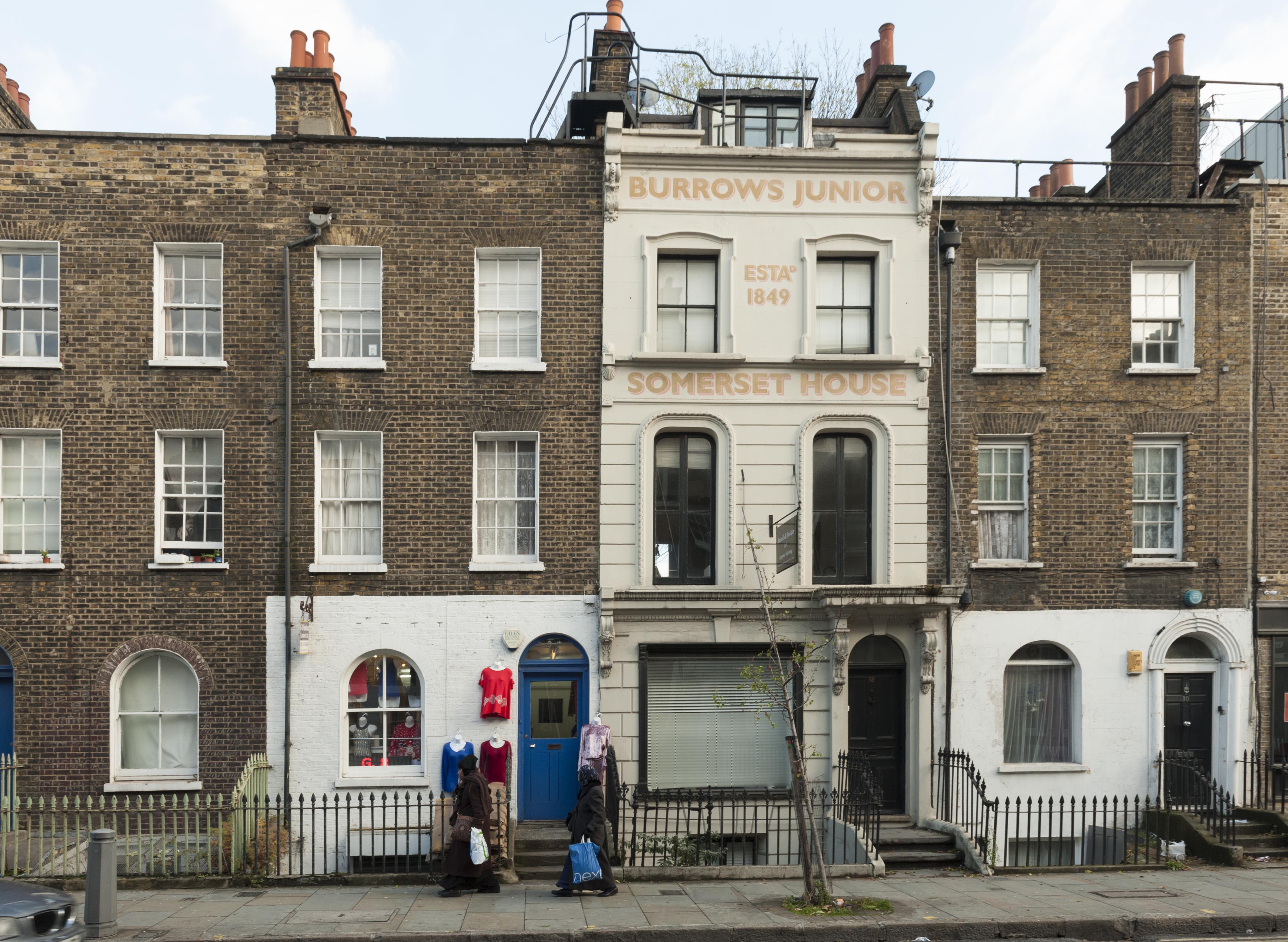
{
"id": 1458,
"title": "10-16 New Road in November 2018",
"author": {
"id": 27,
"username": "DerekKendall"
},
"feature": {
"id": 1135,
"type": "Feature",
"geometry": {
"type": "MultiPolygon",
"coordinates": [
[
[
[
-0.061938871316412,
51.51538025540808
],
[
-0.061827847722865,
51.51538932820588
],
[
-0.061824316933417,
51.51537248761009
],
[
-0.061769739293505,
51.515376712236055
],
[
-0.0617652840551,
51.51535363242298
],
[
-0.061819909564877,
51.515349190087086
],
[
-0.06193045363785,
51.51534015647431
],
[
-0.061938871316412,
51.51538025540808
]
]
]
]
},
"properties": {
"b_number": "14",
"b_name": "",
"street": "New Road",
"address": "14 New Road",
"feature_type": "WHITECHAPEL_BUILDING",
"count": 6,
"search_str": "14 New Road"
},
"tags": []
},
"file": "https://surveyoflondon.org/media/uploads/features/1135/SoL%20Whitechapel%20102451.jpg",
"description": "",
"copyright": true,
"created": "2018-11-28"
}
]
}