HTTP 200 OK
Allow: GET, HEAD, OPTIONS
Content-Type: application/json
Vary: Accept
{
"count": 1747,
"next": "https://surveyoflondon.org/api/v1/images/?format=api&page=69",
"previous": "https://surveyoflondon.org/api/v1/images/?format=api&page=67",
"results": [
{
"id": 1586,
"title": "2 Whitechurch Lane from the northwest in 2019",
"author": {
"id": 27,
"username": "DerekKendall"
},
"feature": {
"id": 156,
"type": "Feature",
"geometry": {
"type": "MultiPolygon",
"coordinates": [
[
[
[
-0.069223851474886,
51.515955924233545
],
[
-0.069143475875129,
51.5159882117629
],
[
-0.069039952977969,
51.515887892128475
],
[
-0.069144701834528,
51.51584581367862
],
[
-0.069231096704407,
51.51592953511854
],
[
-0.069223851474886,
51.515955924233545
]
]
]
]
},
"properties": {
"b_number": "2",
"b_name": "Sushino En (formerly St Mary's House)",
"street": "White Church Lane",
"address": "2 White Church Lane",
"feature_type": "WHITECHAPEL_BUILDING",
"count": 6,
"search_str": "Sushino En (formerly St Mary's House)"
},
"tags": [
"clergy house",
"Herbert O. Ellis",
"St Mary Matfelon"
]
},
"file": "https://surveyoflondon.org/media/uploads/features/156/SoL%20Whitechapel%20102692.jpg",
"description": "",
"copyright": true,
"created": "2019-04-30"
},
{
"id": 1587,
"title": "2 Whitechurch Lane, door detail",
"author": {
"id": 27,
"username": "DerekKendall"
},
"feature": {
"id": 156,
"type": "Feature",
"geometry": {
"type": "MultiPolygon",
"coordinates": [
[
[
[
-0.069223851474886,
51.515955924233545
],
[
-0.069143475875129,
51.5159882117629
],
[
-0.069039952977969,
51.515887892128475
],
[
-0.069144701834528,
51.51584581367862
],
[
-0.069231096704407,
51.51592953511854
],
[
-0.069223851474886,
51.515955924233545
]
]
]
]
},
"properties": {
"b_number": "2",
"b_name": "Sushino En (formerly St Mary's House)",
"street": "White Church Lane",
"address": "2 White Church Lane",
"feature_type": "WHITECHAPEL_BUILDING",
"count": 6,
"search_str": "Sushino En (formerly St Mary's House)"
},
"tags": [
"clergy house",
"Herbert O. Ellis",
"St Mary Matfelon"
]
},
"file": "https://surveyoflondon.org/media/uploads/features/156/SoL%20Whitechapel%20102693.jpg",
"description": "",
"copyright": true,
"created": "2019-04-30"
},
{
"id": 1593,
"title": "Royal Mint Green, 2019",
"author": {
"id": 27,
"username": "DerekKendall"
},
"feature": {
"id": 1696,
"type": "Feature",
"geometry": {
"type": "MultiPolygon",
"coordinates": [
[
[
[
-0.070757877460671,
51.509704781845734
],
[
-0.070336266038682,
51.509780523572594
],
[
-0.070160800693106,
51.50939470250228
],
[
-0.07059267797467,
51.50932348184877
],
[
-0.070757877460671,
51.509704781845734
]
]
]
]
},
"properties": {
"b_number": "",
"b_name": "",
"street": "",
"address": "Royal Mint Green",
"feature_type": "OPEN_SPACE",
"count": 10,
"search_str": "Royal Mint Green"
},
"tags": []
},
"file": "https://surveyoflondon.org/media/uploads/features/1696/SoL%20Whitechapel%20102720.jpg",
"description": "",
"copyright": true,
"created": "2019-04-30"
},
{
"id": 1594,
"title": "Royal Mint Green, south side in 2019",
"author": {
"id": 27,
"username": "DerekKendall"
},
"feature": {
"id": 1696,
"type": "Feature",
"geometry": {
"type": "MultiPolygon",
"coordinates": [
[
[
[
-0.070757877460671,
51.509704781845734
],
[
-0.070336266038682,
51.509780523572594
],
[
-0.070160800693106,
51.50939470250228
],
[
-0.07059267797467,
51.50932348184877
],
[
-0.070757877460671,
51.509704781845734
]
]
]
]
},
"properties": {
"b_number": "",
"b_name": "",
"street": "",
"address": "Royal Mint Green",
"feature_type": "OPEN_SPACE",
"count": 10,
"search_str": "Royal Mint Green"
},
"tags": []
},
"file": "https://surveyoflondon.org/media/uploads/features/1696/SoL%20Whitechapel%20102724.jpg",
"description": "",
"copyright": true,
"created": "2019-04-30"
},
{
"id": 1595,
"title": "Royal Mint Estate from Cartwright Street in 2019",
"author": {
"id": 27,
"username": "DerekKendall"
},
"feature": {
"id": 1716,
"type": "Feature",
"geometry": {
"type": "MultiPolygon",
"coordinates": [
[
[
[
-0.07042902266124,
51.50921845475734
],
[
-0.070520210717819,
51.50920566394245
],
[
-0.070478001452359,
51.50909930037461
],
[
-0.070388779173881,
51.509113085856626
],
[
-0.070419903258892,
51.509195454964015
],
[
-0.07042902266124,
51.50921845475734
]
]
]
]
},
"properties": {
"b_number": "17-23",
"b_name": "",
"street": "Cartwright Street",
"address": "17-23 Cartwright Street on the Royal Mint Estate",
"feature_type": "WHITECHAPEL_BUILDING",
"count": 7,
"search_str": "17-23 Cartwright Street on the Royal Mint Estate"
},
"tags": []
},
"file": "https://surveyoflondon.org/media/uploads/features/1716/SoL%20Whitechapel%20102725.jpg",
"description": "",
"copyright": true,
"created": "2019-04-30"
},
{
"id": 1598,
"title": "Whitechapel Peabody Estate, central square from the northwest in 2019",
"author": {
"id": 27,
"username": "DerekKendall"
},
"feature": {
"id": 1346,
"type": "Feature",
"geometry": {
"type": "MultiPolygon",
"coordinates": [
[
[
[
-0.069067008972636,
51.50986725975222
],
[
-0.069106352740441,
51.5098566757731
],
[
-0.069211130948674,
51.509915623290595
],
[
-0.069230637610419,
51.50991120651011
],
[
-0.069332212512404,
51.51008725367436
],
[
-0.069206709206167,
51.51011545199817
],
[
-0.069067008972636,
51.50986725975222
]
]
]
]
},
"properties": {
"b_number": "",
"b_name": "Darbishire Place (Block M)",
"street": "John Fisher Street",
"address": "Darbishire Place (Block M), John Fisher Street, Peabody Estate Whitechapel",
"feature_type": "WHITECHAPEL_BUILDING",
"count": 10,
"search_str": "Darbishire Place (Block M)"
},
"tags": []
},
"file": "https://surveyoflondon.org/media/uploads/features/1346/SoL%20Whitechapel%20102727.jpg",
"description": "",
"copyright": true,
"created": "2019-04-30"
},
{
"id": 1599,
"title": "Whitechapel Peabody Estate, view through central play area in 2019",
"author": {
"id": 27,
"username": "DerekKendall"
},
"feature": {
"id": 1346,
"type": "Feature",
"geometry": {
"type": "MultiPolygon",
"coordinates": [
[
[
[
-0.069067008972636,
51.50986725975222
],
[
-0.069106352740441,
51.5098566757731
],
[
-0.069211130948674,
51.509915623290595
],
[
-0.069230637610419,
51.50991120651011
],
[
-0.069332212512404,
51.51008725367436
],
[
-0.069206709206167,
51.51011545199817
],
[
-0.069067008972636,
51.50986725975222
]
]
]
]
},
"properties": {
"b_number": "",
"b_name": "Darbishire Place (Block M)",
"street": "John Fisher Street",
"address": "Darbishire Place (Block M), John Fisher Street, Peabody Estate Whitechapel",
"feature_type": "WHITECHAPEL_BUILDING",
"count": 10,
"search_str": "Darbishire Place (Block M)"
},
"tags": []
},
"file": "https://surveyoflondon.org/media/uploads/features/1346/SoL%20Whitechapel%20102731.jpg",
"description": "",
"copyright": true,
"created": "2019-04-30"
},
{
"id": 1600,
"title": "Darbishire Place and Block J in 2019",
"author": {
"id": 27,
"username": "DerekKendall"
},
"feature": {
"id": 1346,
"type": "Feature",
"geometry": {
"type": "MultiPolygon",
"coordinates": [
[
[
[
-0.069067008972636,
51.50986725975222
],
[
-0.069106352740441,
51.5098566757731
],
[
-0.069211130948674,
51.509915623290595
],
[
-0.069230637610419,
51.50991120651011
],
[
-0.069332212512404,
51.51008725367436
],
[
-0.069206709206167,
51.51011545199817
],
[
-0.069067008972636,
51.50986725975222
]
]
]
]
},
"properties": {
"b_number": "",
"b_name": "Darbishire Place (Block M)",
"street": "John Fisher Street",
"address": "Darbishire Place (Block M), John Fisher Street, Peabody Estate Whitechapel",
"feature_type": "WHITECHAPEL_BUILDING",
"count": 10,
"search_str": "Darbishire Place (Block M)"
},
"tags": []
},
"file": "https://surveyoflondon.org/media/uploads/features/1346/SoL%20Whitechapel%20102733.jpg",
"description": "",
"copyright": true,
"created": "2019-04-30"
},
{
"id": 1597,
"title": "55 Royal Mint Street in 2019",
"author": {
"id": 27,
"username": "DerekKendall"
},
"feature": {
"id": 1341,
"type": "Feature",
"geometry": {
"type": "MultiPolygon",
"coordinates": [
[
[
[
-0.069674995219055,
51.510563447847346
],
[
-0.069470567670017,
51.51060542474273
],
[
-0.069427122021502,
51.51052602242747
],
[
-0.069442800926851,
51.51052243635141
],
[
-0.069431192855565,
51.51050552752134
],
[
-0.069544490086559,
51.510480187394315
],
[
-0.069622428211284,
51.5105273163852
],
[
-0.069656877702612,
51.51052349248554
],
[
-0.069674995219055,
51.510563447847346
]
]
]
]
},
"properties": {
"b_number": "55",
"b_name": "Tower Mint Apartments",
"street": "Royal Mint Street",
"address": "Tower Mint Apartments, 55 Royal Mint Street (with 84 John Fisher Street)",
"feature_type": "WHITECHAPEL_BUILDING",
"count": 6,
"search_str": "Tower Mint Apartments"
},
"tags": []
},
"file": "https://surveyoflondon.org/media/uploads/features/1341/SoL%20Whitechapel%20102746.jpg",
"description": "",
"copyright": true,
"created": "2019-04-30"
},
{
"id": 1570,
"title": "1-7 Prescot Street, overdoor sculpture in 2017",
"author": {
"id": 27,
"username": "DerekKendall"
},
"feature": {
"id": 1286,
"type": "Feature",
"geometry": {
"type": "MultiPolygon",
"coordinates": [
[
[
[
-0.069793489547983,
51.511271968219916
],
[
-0.069965917865997,
51.51168028661196
],
[
-0.069243122619495,
51.51179800135946
],
[
-0.069187619352883,
51.51178700909154
],
[
-0.068924065744909,
51.51144633157197
],
[
-0.069110518275552,
51.511389634471044
],
[
-0.069125928884571,
51.51138051294904
],
[
-0.069793489547983,
51.511271968219916
]
],
[
[
-0.069773263237786,
51.511528283268085
],
[
-0.069730353342622,
51.51143265236416
],
[
-0.069244663174936,
51.511517503411056
],
[
-0.069318177103272,
51.51160868474515
],
[
-0.069773263237786,
51.511528283268085
]
]
]
]
},
"properties": {
"b_number": "1-7",
"b_name": "",
"street": "Prescot Street",
"address": "1-7 Prescot Street",
"feature_type": "WHITECHAPEL_BUILDING",
"count": 12,
"search_str": "1-7 Prescot Street"
},
"tags": [
"Co-operative Wholesale Society",
"L. G. Ekins"
]
},
"file": "https://surveyoflondon.org/media/uploads/features/1286/SoL%20Whitechapel%20101111.jpg",
"description": "",
"copyright": true,
"created": "2019-03-20"
},
{
"id": 462,
"title": "Plaque on west elevation of the Garrod Building",
"author": {
"id": 11,
"username": "amyspencer"
},
"feature": {
"id": 1189,
"type": "Feature",
"geometry": {
"type": "MultiPolygon",
"coordinates": [
[
[
[
-0.060957318414032,
51.51782190843071
],
[
-0.060536358742238,
51.517916494366496
],
[
-0.06042382559955,
51.5177169757099
],
[
-0.060423392052643,
51.517716267459285
],
[
-0.06037583590265,
51.51772558880798
],
[
-0.060352091559155,
51.517682266082666
],
[
-0.060399184829325,
51.5176714337657
],
[
-0.060382136461735,
51.517636775872596
],
[
-0.060366794729858,
51.51763667842599
],
[
-0.060353568375337,
51.517633521256826
],
[
-0.060340249107007,
51.51762886391949
],
[
-0.060331431296148,
51.51762072004323
],
[
-0.060328691457909,
51.51761554771857
],
[
-0.060326999079391,
51.517611443342886
],
[
-0.060327382221525,
51.517606284181284
],
[
-0.060329047985828,
51.51760203725169
],
[
-0.060331232366157,
51.517597910289986
],
[
-0.060333234968373,
51.517593887621835
],
[
-0.0603394749266,
51.51758477508556
],
[
-0.060343650894546,
51.51757832358151
],
[
-0.060315667444656,
51.51752195768432
],
[
-0.060339055445574,
51.51749626222509
],
[
-0.06039972958586,
51.51748509401273
],
[
-0.060844270778094,
51.51743888994093
],
[
-0.060875340433462,
51.517555246058656
],
[
-0.060894657489377,
51.517564918111205
],
[
-0.060905236784801,
51.51757830806902
],
[
-0.060907454524091,
51.51759005281749
],
[
-0.060906490522428,
51.51760128121761
],
[
-0.060896928755295,
51.51761642472545
],
[
-0.060890333226028,
51.51762687042926
],
[
-0.060957318414032,
51.51782190843071
]
]
]
]
},
"properties": {
"b_number": "",
"b_name": "Garrod Building",
"street": "Stepney Way",
"address": "Garrod Building",
"feature_type": "WHITECHAPEL_BUILDING",
"count": 31,
"search_str": "Garrod Building"
},
"tags": []
},
"file": "https://surveyoflondon.org/media/uploads/features/1189/IMG_9389.JPG",
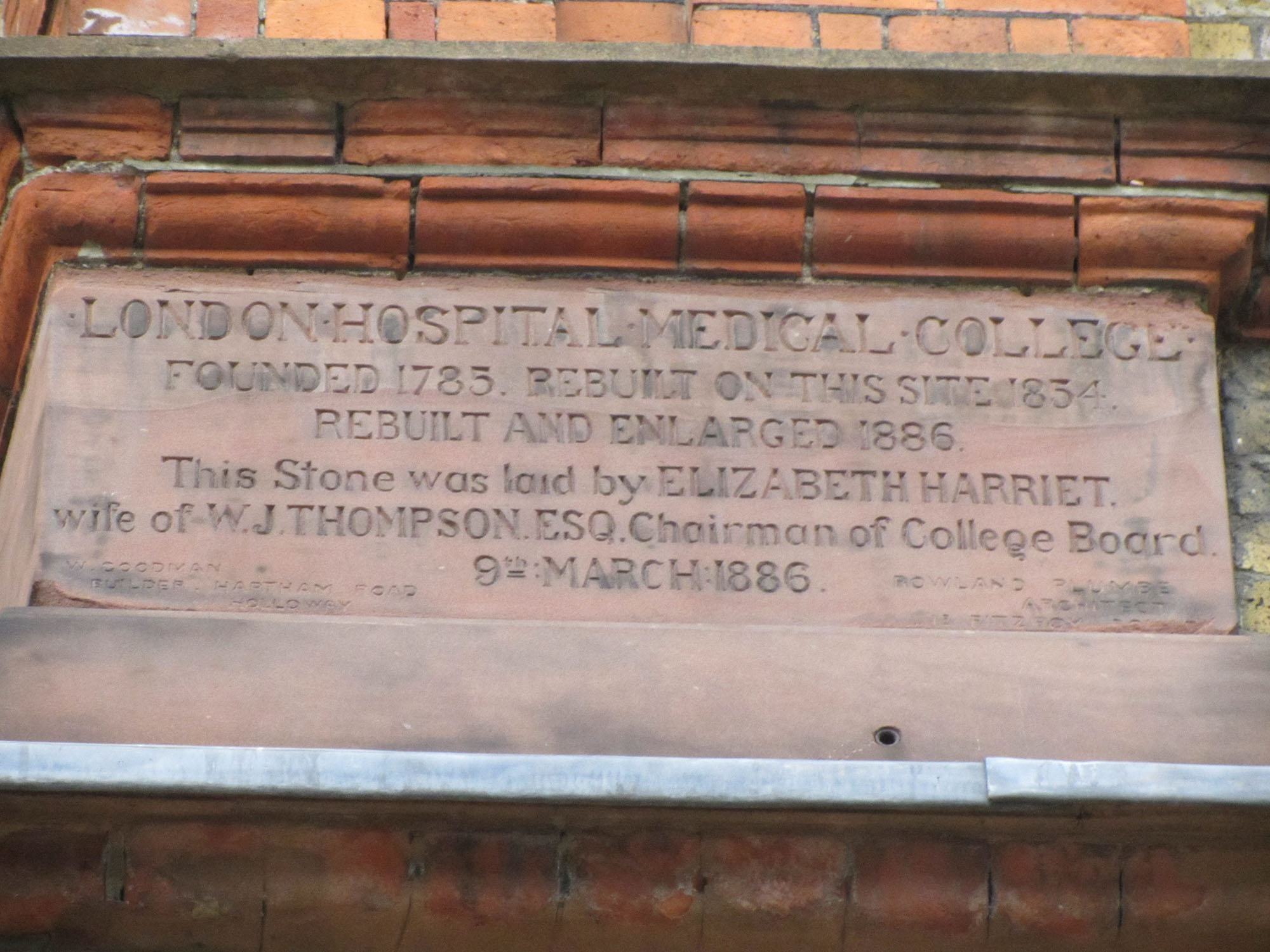
"description": "On the west elevation of the Garrod Building, a stone plaque commemorates the history of the London Hospital Medical College. Its inscription notes that the college moved to its site at the north-east corner of Turner Street at Stepney Way in 1854, and was extended in 1886. At its base, the plaque bears the names of its builder (W. Goodman of Hartham Road, Holloway) and its architect (Rowland Plumbe, 13 Fitzroy Square). ",
"copyright": false,
"created": "2016-12-12"
},
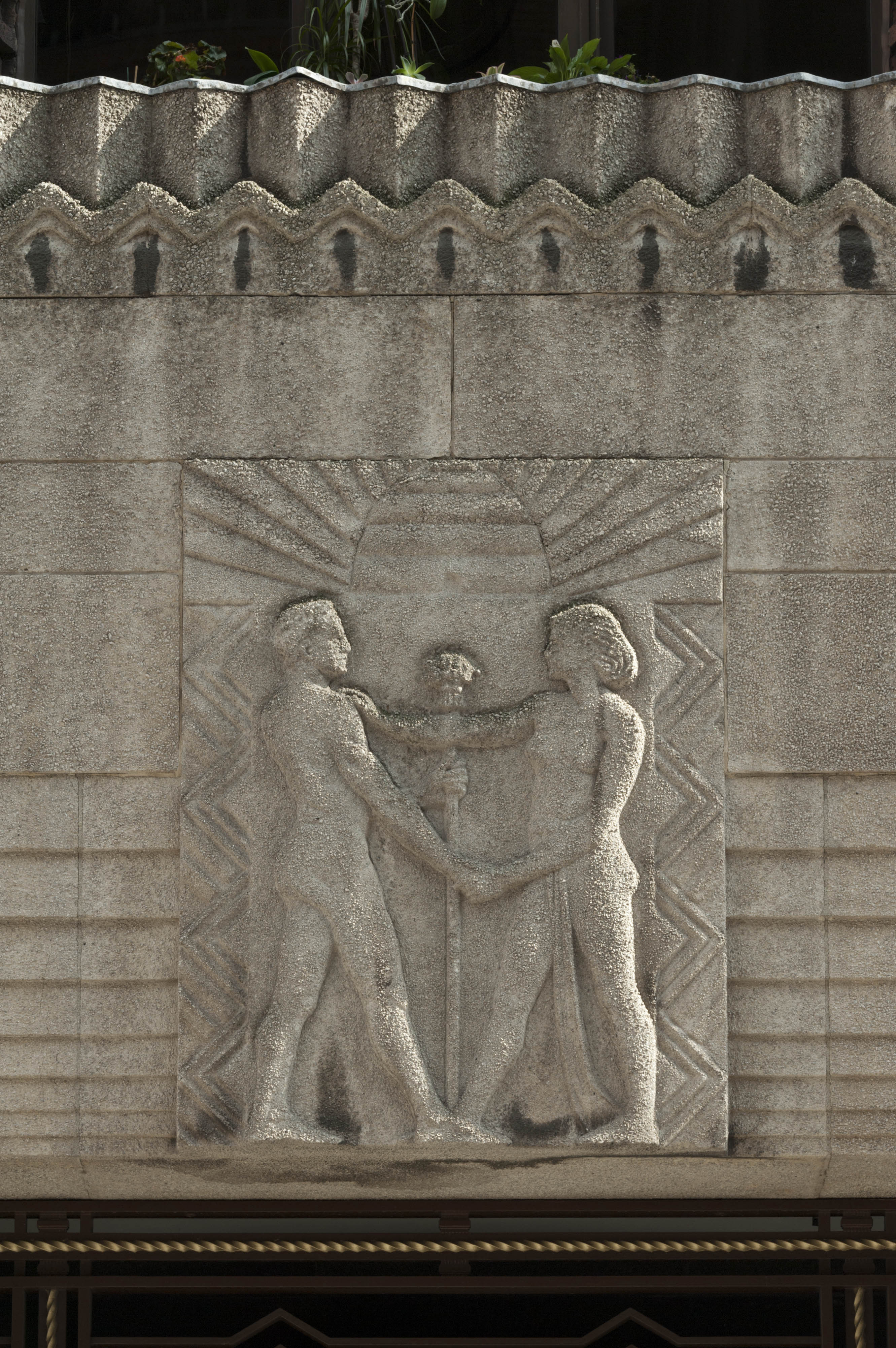
{
"id": 497,
"title": "Painting in the basement of the Garrod Building",
"author": {
"id": 11,
"username": "amyspencer"
},
"feature": {
"id": 1189,
"type": "Feature",
"geometry": {
"type": "MultiPolygon",
"coordinates": [
[
[
[
-0.060957318414032,
51.51782190843071
],
[
-0.060536358742238,
51.517916494366496
],
[
-0.06042382559955,
51.5177169757099
],
[
-0.060423392052643,
51.517716267459285
],
[
-0.06037583590265,
51.51772558880798
],
[
-0.060352091559155,
51.517682266082666
],
[
-0.060399184829325,
51.5176714337657
],
[
-0.060382136461735,
51.517636775872596
],
[
-0.060366794729858,
51.51763667842599
],
[
-0.060353568375337,
51.517633521256826
],
[
-0.060340249107007,
51.51762886391949
],
[
-0.060331431296148,
51.51762072004323
],
[
-0.060328691457909,
51.51761554771857
],
[
-0.060326999079391,
51.517611443342886
],
[
-0.060327382221525,
51.517606284181284
],
[
-0.060329047985828,
51.51760203725169
],
[
-0.060331232366157,
51.517597910289986
],
[
-0.060333234968373,
51.517593887621835
],
[
-0.0603394749266,
51.51758477508556
],
[
-0.060343650894546,
51.51757832358151
],
[
-0.060315667444656,
51.51752195768432
],
[
-0.060339055445574,
51.51749626222509
],
[
-0.06039972958586,
51.51748509401273
],
[
-0.060844270778094,
51.51743888994093
],
[
-0.060875340433462,
51.517555246058656
],
[
-0.060894657489377,
51.517564918111205
],
[
-0.060905236784801,
51.51757830806902
],
[
-0.060907454524091,
51.51759005281749
],
[
-0.060906490522428,
51.51760128121761
],
[
-0.060896928755295,
51.51761642472545
],
[
-0.060890333226028,
51.51762687042926
],
[
-0.060957318414032,
51.51782190843071
]
]
]
]
},
"properties": {
"b_number": "",
"b_name": "Garrod Building",
"street": "Stepney Way",
"address": "Garrod Building",
"feature_type": "WHITECHAPEL_BUILDING",
"count": 31,
"search_str": "Garrod Building"
},
"tags": []
},
"file": "https://surveyoflondon.org/media/uploads/features/1189/IMG_9937_Hxsmsvn.JPG",
"description": "Painting on canvas in the basement of the Garrod Building, on the approach to the tunnel to the Outpatients Department. \nUnknown artist, c.1970s\nPhotographed in February 2017",
"copyright": false,
"created": "2017-02-21"
},
{
"id": 1585,
"title": "View to west along Whitechapel Road in April 2019",
"author": {
"id": 27,
"username": "DerekKendall"
},
"feature": {
"id": 1698,
"type": "Feature",
"geometry": {
"type": "MultiPolygon",
"coordinates": [
[
[
[
-0.062755898137067,
51.51857235799611
],
[
-0.058216859270041,
51.51960039921044
],
[
-0.058148482851386,
51.51948612756745
],
[
-0.061091729886378,
51.51883423152082
],
[
-0.061616259170046,
51.51871888429734
],
[
-0.06270768344222,
51.51847582817058
],
[
-0.062755898137067,
51.51857235799611
]
]
]
]
},
"properties": {
"b_number": "",
"b_name": "",
"street": "Whitechapel Road",
"address": "Whitechapel Market, Whitechapel Road",
"feature_type": "PLACE",
"count": 48,
"search_str": "Whitechapel Market, Whitechapel Road"
},
"tags": []
},
"file": "https://surveyoflondon.org/media/uploads/features/1698/SoL%20Whitechapel%20102685.jpg",
"description": "",
"copyright": true,
"created": "2019-04-30"
},
{
"id": 1137,
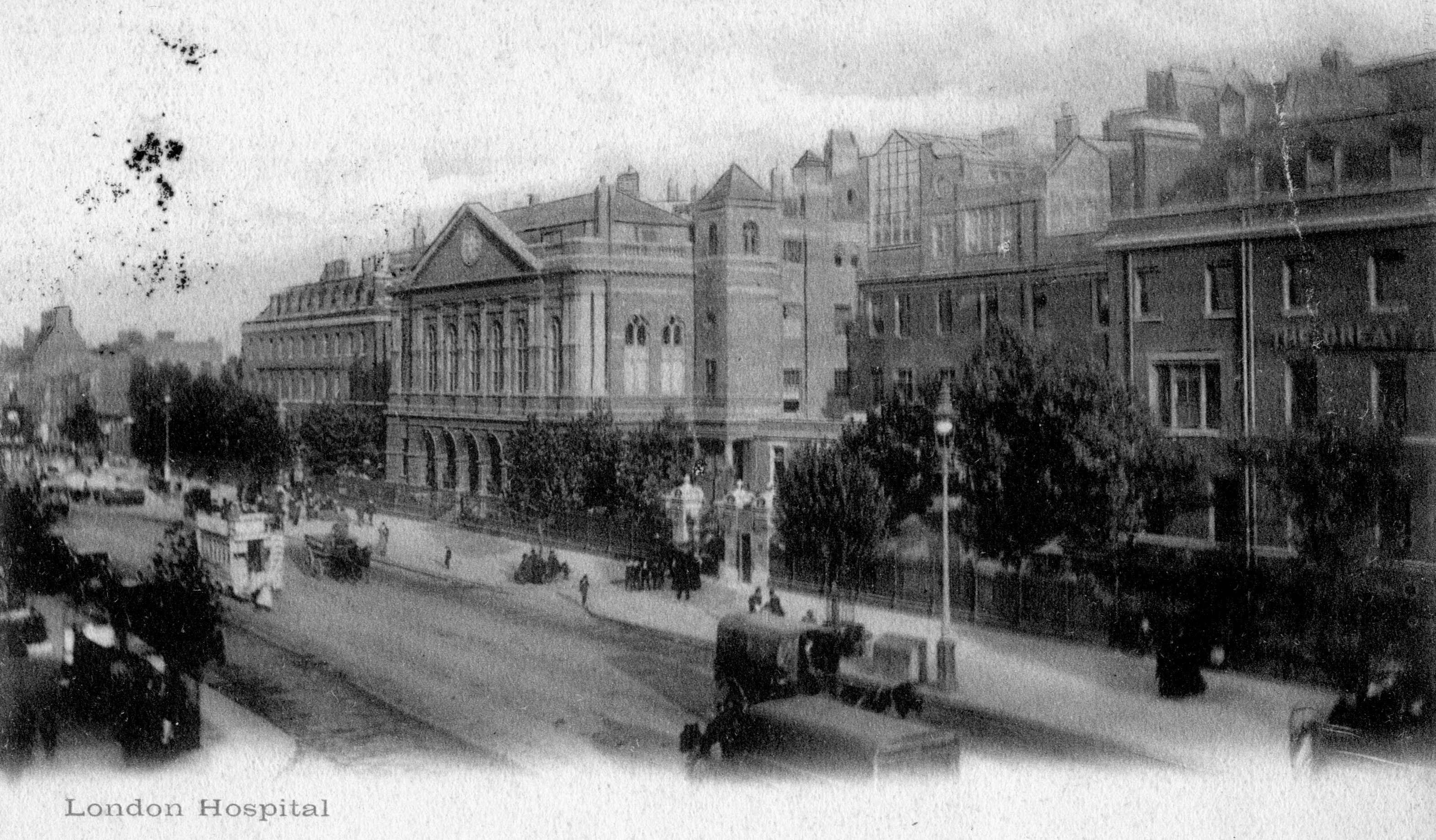
"title": "Front of the London Hospital, view from the north-west on a 1916 postcard",
"author": {
"id": 2,
"username": "surveyoflondon"
},
"feature": {
"id": 1230,
"type": "Feature",
"geometry": {
"type": "MultiPolygon",
"coordinates": [
[
[
[
-0.06071898744648,
51.51847914149303
],
[
-0.060743358937849,
51.518529899918775
],
[
-0.060362148562617,
51.518618013153
],
[
-0.060404024127419,
51.51868851949335
],
[
-0.060356952993906,
51.51869974522794
],
[
-0.060399234817198,
51.51877056309998
],
[
-0.060042469531136,
51.5188530372297
],
[
-0.060006551123239,
51.51879256032364
],
[
-0.05997171006068,
51.51880061452483
],
[
-0.059923949522789,
51.51872019830377
],
[
-0.059602716389847,
51.51879445706454
],
[
-0.059631951693606,
51.51884368227145
],
[
-0.059135089420495,
51.51895853862307
],
[
-0.059031394281591,
51.51878393727422
],
[
-0.059075483581288,
51.51877374555587
],
[
-0.05923306113512,
51.518737319626666
],
[
-0.059261815633844,
51.518785736083466
],
[
-0.059453095208379,
51.51874286661955
],
[
-0.059437777096903,
51.51871791341666
],
[
-0.059509844762857,
51.518701022201654
],
[
-0.059472510825189,
51.51863713193043
],
[
-0.059893693119402,
51.51853565124978
],
[
-0.059897251108141,
51.51854177905041
],
[
-0.060406197614306,
51.5184267554985
],
[
-0.060388475186227,
51.51839623334771
],
[
-0.060226549751936,
51.51811735804654
],
[
-0.060490662909997,
51.51805857683586
],
[
-0.060500593175314,
51.518078725457706
],
[
-0.06071898744648,
51.51847914149303
]
]
]
]
},
"properties": {
"b_number": "",
"b_name": "Former Royal London Hospital",
"street": "",
"address": "Former Royal London Hospital ",
"feature_type": "WHITECHAPEL_BUILDING",
"count": 53,
"search_str": "Former Royal London Hospital"
},
"tags": []
},
"file": "https://surveyoflondon.org/media/uploads/features/1230/Front%20from%20NW008.jpg",
"description": "",
"copyright": false,
"created": "2018-02-14"
},
{
"id": 1274,
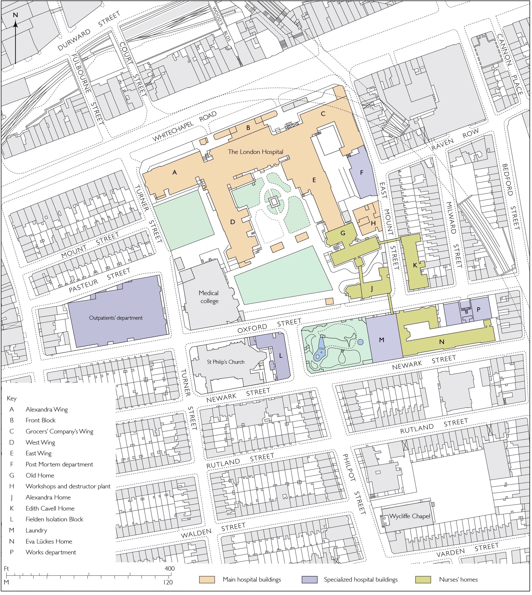
"title": "Map of the London Hospital and its surroundings, c.1919",
"author": {
"id": 2,
"username": "surveyoflondon"
},
"feature": {
"id": 1230,
"type": "Feature",
"geometry": {
"type": "MultiPolygon",
"coordinates": [
[
[
[
-0.06071898744648,
51.51847914149303
],
[
-0.060743358937849,
51.518529899918775
],
[
-0.060362148562617,
51.518618013153
],
[
-0.060404024127419,
51.51868851949335
],
[
-0.060356952993906,
51.51869974522794
],
[
-0.060399234817198,
51.51877056309998
],
[
-0.060042469531136,
51.5188530372297
],
[
-0.060006551123239,
51.51879256032364
],
[
-0.05997171006068,
51.51880061452483
],
[
-0.059923949522789,
51.51872019830377
],
[
-0.059602716389847,
51.51879445706454
],
[
-0.059631951693606,
51.51884368227145
],
[
-0.059135089420495,
51.51895853862307
],
[
-0.059031394281591,
51.51878393727422
],
[
-0.059075483581288,
51.51877374555587
],
[
-0.05923306113512,
51.518737319626666
],
[
-0.059261815633844,
51.518785736083466
],
[
-0.059453095208379,
51.51874286661955
],
[
-0.059437777096903,
51.51871791341666
],
[
-0.059509844762857,
51.518701022201654
],
[
-0.059472510825189,
51.51863713193043
],
[
-0.059893693119402,
51.51853565124978
],
[
-0.059897251108141,
51.51854177905041
],
[
-0.060406197614306,
51.5184267554985
],
[
-0.060388475186227,
51.51839623334771
],
[
-0.060226549751936,
51.51811735804654
],
[
-0.060490662909997,
51.51805857683586
],
[
-0.060500593175314,
51.518078725457706
],
[
-0.06071898744648,
51.51847914149303
]
]
]
]
},
"properties": {
"b_number": "",
"b_name": "Former Royal London Hospital",
"street": "",
"address": "Former Royal London Hospital ",
"feature_type": "WHITECHAPEL_BUILDING",
"count": 53,
"search_str": "Former Royal London Hospital"
},
"tags": []
},
"file": "https://surveyoflondon.org/media/uploads/features/1230/London%20Hospital%20block%20plan%20final_5REZjp0.jpg",
"description": "Redrawn by Helen Jones from the Ordnance Survey maps of c.1919 and c.1948.",
"copyright": false,
"created": "2018-07-03"
},
{
"id": 1275,
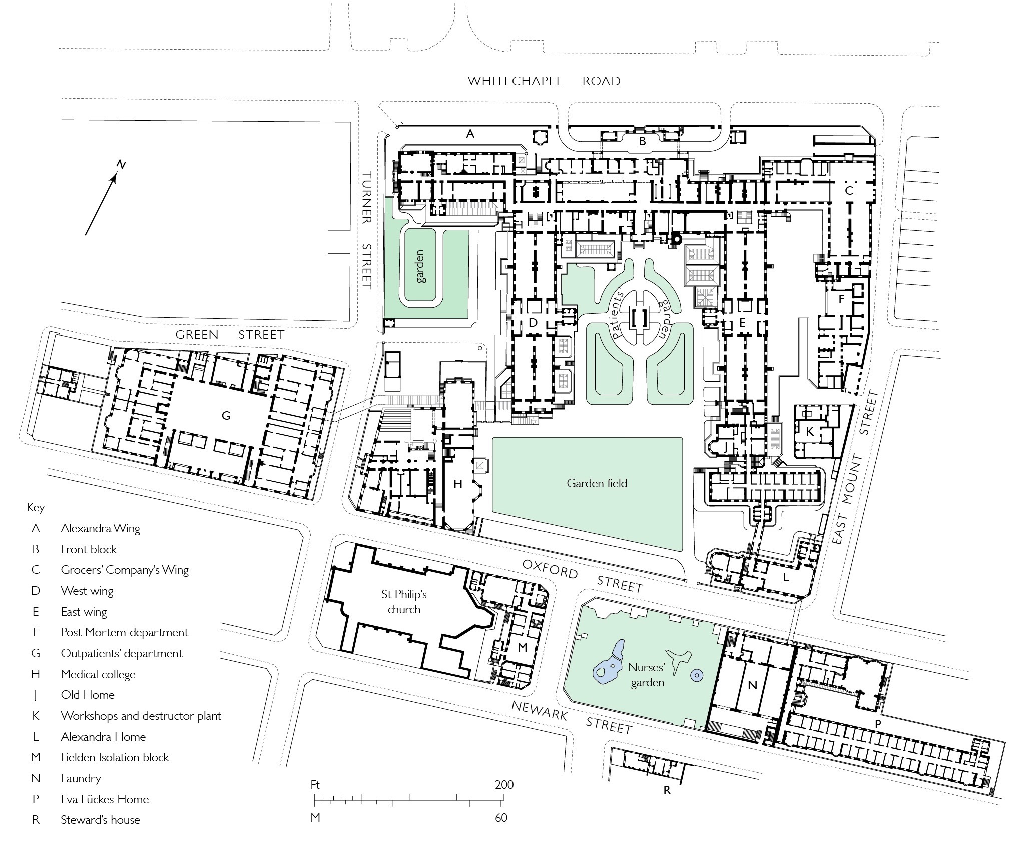
"title": "Ground plan of the London Hospital in 1905",
"author": {
"id": 2,
"username": "surveyoflondon"
},
"feature": {
"id": 1230,
"type": "Feature",
"geometry": {
"type": "MultiPolygon",
"coordinates": [
[
[
[
-0.06071898744648,
51.51847914149303
],
[
-0.060743358937849,
51.518529899918775
],
[
-0.060362148562617,
51.518618013153
],
[
-0.060404024127419,
51.51868851949335
],
[
-0.060356952993906,
51.51869974522794
],
[
-0.060399234817198,
51.51877056309998
],
[
-0.060042469531136,
51.5188530372297
],
[
-0.060006551123239,
51.51879256032364
],
[
-0.05997171006068,
51.51880061452483
],
[
-0.059923949522789,
51.51872019830377
],
[
-0.059602716389847,
51.51879445706454
],
[
-0.059631951693606,
51.51884368227145
],
[
-0.059135089420495,
51.51895853862307
],
[
-0.059031394281591,
51.51878393727422
],
[
-0.059075483581288,
51.51877374555587
],
[
-0.05923306113512,
51.518737319626666
],
[
-0.059261815633844,
51.518785736083466
],
[
-0.059453095208379,
51.51874286661955
],
[
-0.059437777096903,
51.51871791341666
],
[
-0.059509844762857,
51.518701022201654
],
[
-0.059472510825189,
51.51863713193043
],
[
-0.059893693119402,
51.51853565124978
],
[
-0.059897251108141,
51.51854177905041
],
[
-0.060406197614306,
51.5184267554985
],
[
-0.060388475186227,
51.51839623334771
],
[
-0.060226549751936,
51.51811735804654
],
[
-0.060490662909997,
51.51805857683586
],
[
-0.060500593175314,
51.518078725457706
],
[
-0.06071898744648,
51.51847914149303
]
]
]
]
},
"properties": {
"b_number": "",
"b_name": "Former Royal London Hospital",
"street": "",
"address": "Former Royal London Hospital ",
"feature_type": "WHITECHAPEL_BUILDING",
"count": 53,
"search_str": "Former Royal London Hospital"
},
"tags": []
},
"file": "https://surveyoflondon.org/media/uploads/features/1230/Plumbe%20London%20Hospital%20plan%20final_QipwU85.jpg",
"description": "Redrawn by Helen Jones from a plan by Rowland Plumbe & Harvey at the Royal London Hospital Archives. ",
"copyright": false,
"created": "2018-07-03"
},
{
"id": 1581,
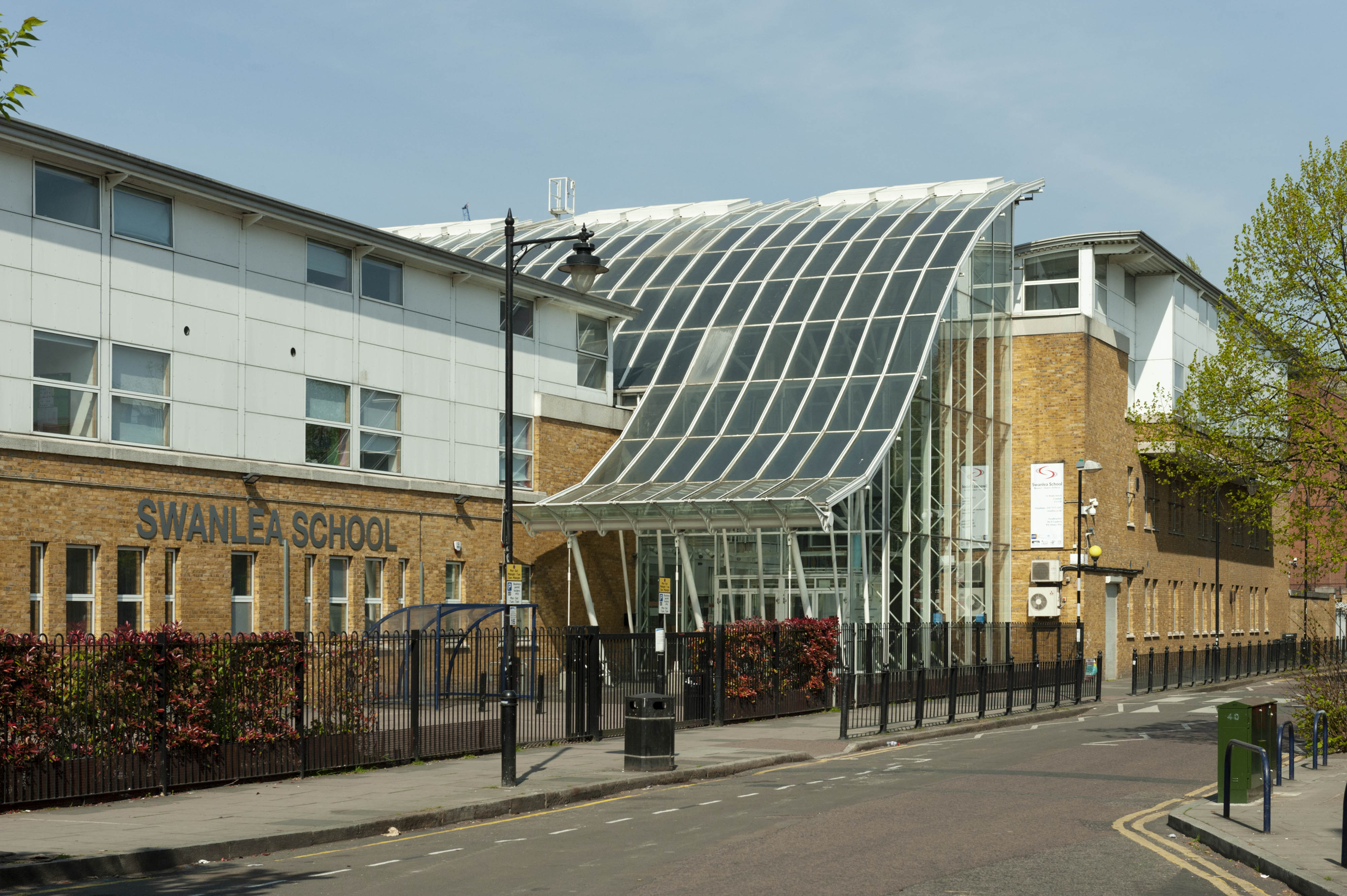
"title": "Swanlea School from the southeast in 2019",
"author": {
"id": 27,
"username": "DerekKendall"
},
"feature": {
"id": 611,
"type": "Feature",
"geometry": {
"type": "MultiPolygon",
"coordinates": [
[
[
[
-0.061071171968994,
51.52081854756523
],
[
-0.060751914384132,
51.520910345673705
],
[
-0.060670800177771,
51.520804404847986
],
[
-0.060468455213489,
51.52086122248221
],
[
-0.060450699740395,
51.52083834953325
],
[
-0.060348963469709,
51.52086716970229
],
[
-0.060327054268411,
51.52084002855742
],
[
-0.060218088338048,
51.52087362145146
],
[
-0.060181870551264,
51.52082767044763
],
[
-0.059888941340425,
51.5209177401419
],
[
-0.059906837511582,
51.520944348074295
],
[
-0.059794155620414,
51.52097953029167
],
[
-0.059832243956796,
51.521028790808174
],
[
-0.059621239031678,
51.52108457365709
],
[
-0.059750656156039,
51.521261628315195
],
[
-0.060092261050819,
51.521162518995624
],
[
-0.060201267294625,
51.5213109827491
],
[
-0.059711284021543,
51.521455446025634
],
[
-0.059608494153443,
51.52131130869682
],
[
-0.059508393196664,
51.521340050168135
],
[
-0.059253117703057,
51.52099166668332
],
[
-0.059256033768267,
51.5209595242491
],
[
-0.059159886666936,
51.520817675044256
],
[
-0.059263515528805,
51.520783743654874
],
[
-0.059005942108209,
51.52046133162211
],
[
-0.059340108320742,
51.520363660572684
],
[
-0.059350977165626,
51.520379010450526
],
[
-0.059653760593448,
51.52029256187745
],
[
-0.059732700862836,
51.52040478191169
],
[
-0.059399004206541,
51.520507265410146
],
[
-0.059386008017351,
51.52050099774739
],
[
-0.059330111279166,
51.52051942249526
],
[
-0.059427473319942,
51.520650551502136
],
[
-0.059335113114943,
51.52067740335036
],
[
-0.059393880270447,
51.52075719296283
],
[
-0.059578966698866,
51.52070547069434
],
[
-0.059521505013312,
51.5206204479455
],
[
-0.059633019030968,
51.52058917356787
],
[
-0.05965569761926,
51.52061535612946
],
[
-0.059758050698807,
51.52058539506149
],
[
-0.059784825395434,
51.520617287071275
],
[
-0.059896250945807,
51.520586175310825
],
[
-0.059905010512797,
51.5206001008183
],
[
-0.060207891820099,
51.520512562603464
],
[
-0.060152819128302,
51.52043377382353
],
[
-0.060255799218263,
51.520404384952066
],
[
-0.060243948876997,
51.520387831372716
],
[
-0.060374285949892,
51.52035112116383
],
[
-0.06040163767932,
51.52038826992398
],
[
-0.060493821347423,
51.520361732013576
],
[
-0.060585729284775,
51.52048450453705
],
[
-0.060667847773396,
51.520461046936504
],
[
-0.060740712007704,
51.520573214734334
],
[
-0.060789668351451,
51.52055928381185
],
[
-0.060862533037535,
51.52067145153698
],
[
-0.060908498405939,
51.52065859991671
],
[
-0.06094600415928,
51.52070981388415
],
[
-0.060904572245245,
51.52072152762277
],
[
-0.060915563003104,
51.5207389782457
],
[
-0.06100155865022,
51.52071591478786
],
[
-0.061071171968994,
51.52081854756523
]
]
]
]
},
"properties": {
"b_number": "",
"b_name": "Swanlea Secondary School",
"street": "Brady Street",
"address": "Swanlea Secondary School, Brady Street and Durward Street",
"feature_type": "WHITECHAPEL_BUILDING",
"count": 20,
"search_str": "Swanlea Secondary School"
},
"tags": []
},
"file": "https://surveyoflondon.org/media/uploads/features/611/SoL%20Whitechapel%20102675.jpg",
"description": "",
"copyright": true,
"created": "2019-04-30"
},
{
"id": 1130,
"title": "Tredegar House, Bow Road",
"author": {
"id": 2,
"username": "surveyoflondon"
},
"feature": {
"id": 1230,
"type": "Feature",
"geometry": {
"type": "MultiPolygon",
"coordinates": [
[
[
[
-0.06071898744648,
51.51847914149303
],
[
-0.060743358937849,
51.518529899918775
],
[
-0.060362148562617,
51.518618013153
],
[
-0.060404024127419,
51.51868851949335
],
[
-0.060356952993906,
51.51869974522794
],
[
-0.060399234817198,
51.51877056309998
],
[
-0.060042469531136,
51.5188530372297
],
[
-0.060006551123239,
51.51879256032364
],
[
-0.05997171006068,
51.51880061452483
],
[
-0.059923949522789,
51.51872019830377
],
[
-0.059602716389847,
51.51879445706454
],
[
-0.059631951693606,
51.51884368227145
],
[
-0.059135089420495,
51.51895853862307
],
[
-0.059031394281591,
51.51878393727422
],
[
-0.059075483581288,
51.51877374555587
],
[
-0.05923306113512,
51.518737319626666
],
[
-0.059261815633844,
51.518785736083466
],
[
-0.059453095208379,
51.51874286661955
],
[
-0.059437777096903,
51.51871791341666
],
[
-0.059509844762857,
51.518701022201654
],
[
-0.059472510825189,
51.51863713193043
],
[
-0.059893693119402,
51.51853565124978
],
[
-0.059897251108141,
51.51854177905041
],
[
-0.060406197614306,
51.5184267554985
],
[
-0.060388475186227,
51.51839623334771
],
[
-0.060226549751936,
51.51811735804654
],
[
-0.060490662909997,
51.51805857683586
],
[
-0.060500593175314,
51.518078725457706
],
[
-0.06071898744648,
51.51847914149303
]
]
]
]
},
"properties": {
"b_number": "",
"b_name": "Former Royal London Hospital",
"street": "",
"address": "Former Royal London Hospital ",
"feature_type": "WHITECHAPEL_BUILDING",
"count": 53,
"search_str": "Former Royal London Hospital"
},
"tags": []
},
"file": "https://surveyoflondon.org/media/uploads/features/1230/Tredegar%20House001.jpg",
"description": "Located east of the London Hospital at 97-99 Bow Road, Tredegar House was built in 1911 to designs by Rowland Plumbe as a nurses' training school.\n\nExcerpt from the back of the postcard, which seems to have been sent from Bow in March 1918:\n'This is where I am until I get moved to the hospital proper. Unfortunately my bedroom is at the back, so the window cannot be seen on card. We have already had a physiology lecture and a cooking class. I have just been out (off from 2 to 4pm), it is a lovely day.'",
"copyright": false,
"created": "2018-02-14"
},
{
"id": 1589,
"title": "8-10 Whitechurch Lane in 2019",
"author": {
"id": 27,
"username": "DerekKendall"
},
"feature": {
"id": 159,
"type": "Feature",
"geometry": {
"type": "MultiPolygon",
"coordinates": [
[
[
[
-0.069035200140217,
51.51571155031097
],
[
-0.068810248810689,
51.51579556643765
],
[
-0.068782546831716,
51.51576529162323
],
[
-0.068817251819231,
51.51574609699002
],
[
-0.068924168772787,
51.51570878172686
],
[
-0.068920705015919,
51.51570534703247
],
[
-0.069008419422413,
51.515675274067185
],
[
-0.069035200140217,
51.51571155031097
]
]
]
]
},
"properties": {
"b_number": "10",
"b_name": "",
"street": "White Church Lane",
"address": "10 White Church Lane",
"feature_type": "WHITECHAPEL_BUILDING",
"count": 4,
"search_str": "10 White Church Lane"
},
"tags": []
},
"file": "https://surveyoflondon.org/media/uploads/features/159/SoL%20Whitechapel%20102697.jpg",
"description": "",
"copyright": true,
"created": "2019-04-30"
},
{
"id": 1273,
"title": "Royal Mint Street 1984/5",
"author": {
"id": 153,
"username": "danny"
},
"feature": {
"id": 1341,
"type": "Feature",
"geometry": {
"type": "MultiPolygon",
"coordinates": [
[
[
[
-0.069674995219055,
51.510563447847346
],
[
-0.069470567670017,
51.51060542474273
],
[
-0.069427122021502,
51.51052602242747
],
[
-0.069442800926851,
51.51052243635141
],
[
-0.069431192855565,
51.51050552752134
],
[
-0.069544490086559,
51.510480187394315
],
[
-0.069622428211284,
51.5105273163852
],
[
-0.069656877702612,
51.51052349248554
],
[
-0.069674995219055,
51.510563447847346
]
]
]
]
},
"properties": {
"b_number": "55",
"b_name": "Tower Mint Apartments",
"street": "Royal Mint Street",
"address": "Tower Mint Apartments, 55 Royal Mint Street (with 84 John Fisher Street)",
"feature_type": "WHITECHAPEL_BUILDING",
"count": 6,
"search_str": "Tower Mint Apartments"
},
"tags": []
},
"file": "https://surveyoflondon.org/media/uploads/features/1341/Royal%20Mint%20Street%20looking%20east.jpg",
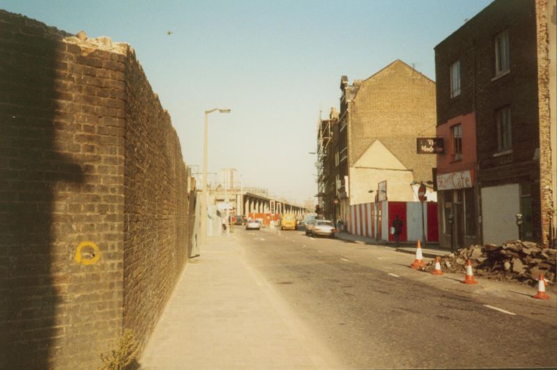
"description": "A picture taken around 1984/5 showing the view eastbound along Royal Mint Street towards the junction with Cable Street. Buildings and the former supports for the railway bridge carrying a spur south towards the London Docks are being demolished in preparation for the construction of the Docklands Light Railway. The new concrete railway viaduct can be seen approaching along Cable Street in the distance.\n\nThe junction with John Fisher Street can be seen in the right foreground with an old sign saying \"Model Inn\" still hanging from the now-demolished building that was on the corner.\n\nRed and white hoardings surround the site, on the corner of John Fisher Street that was the location of Harts Grocery Shop - see other images on this site.",
"copyright": false,
"created": "2018-06-18"
}
]
}