HTTP 200 OK
Allow: GET, HEAD, OPTIONS
Content-Type: application/json
Vary: Accept
{
"count": 1747,
"next": "https://surveyoflondon.org/api/v1/images/?format=api&page=65",
"previous": "https://surveyoflondon.org/api/v1/images/?format=api&page=63",
"results": [
{
"id": 1183,
"title": "Wilton's Music Hall in early 2018, frontage of the Mahogany Bar",
"author": {
"id": 27,
"username": "DerekKendall"
},
"feature": {
"id": 1392,
"type": "Feature",
"geometry": {
"type": "MultiPolygon",
"coordinates": [
[
[
[
-0.066897382560978,
51.51047185184401
],
[
-0.066897150320887,
51.510543358461234
],
[
-0.066964310871808,
51.51054939761258
],
[
-0.067031736648758,
51.51055546057313
],
[
-0.067033159620775,
51.51054385631446
],
[
-0.067124985785421,
51.51055249759738
],
[
-0.067119646867151,
51.510573278551
],
[
-0.067097006082147,
51.51057630354935
],
[
-0.067064204301052,
51.510690877240464
],
[
-0.066813595729658,
51.51071232706844
],
[
-0.066808845661517,
51.510692481646345
],
[
-0.066750873450789,
51.51069733978511
],
[
-0.066731248551372,
51.51054469318253
],
[
-0.066802206282857,
51.51054121190127
],
[
-0.066805453245557,
51.51046452251118
],
[
-0.066897382560978,
51.51047185184401
]
]
]
]
},
"properties": {
"b_number": "1",
"b_name": "Wilton's Music Hall",
"street": "Graces Alley",
"address": "Wilton's Music Hall, 1 Graces Alley",
"feature_type": "WHITECHAPEL_BUILDING",
"count": 23,
"search_str": "Wilton's Music Hall"
},
"tags": [
"Wilton's Music Hall"
]
},
"file": "https://surveyoflondon.org/media/uploads/features/1392/SoL%20Whitechapel%20101801.jpg",
"description": "",
"copyright": true,
"created": "2018-03-05"
},
{
"id": 755,
"title": "Royal Brunswick Theatre (Front Elevation)",
"author": {
"id": 33,
"username": "Charno"
},
"feature": {
"id": 1385,
"type": "Feature",
"geometry": {
"type": "MultiPolygon",
"coordinates": [
[
[
[
-0.067575803709333,
51.51021492278667
],
[
-0.067783647338447,
51.51017527172947
],
[
-0.067828706900756,
51.510167293395675
],
[
-0.067884358000762,
51.51028332470727
],
[
-0.068021222270461,
51.51026117174896
],
[
-0.068027105232624,
51.51027869995762
],
[
-0.068059007104689,
51.51027341168682
],
[
-0.068045803249401,
51.51025517119752
],
[
-0.068185711037114,
51.51022956959143
],
[
-0.068302205657116,
51.51049311218949
],
[
-0.068154065018083,
51.51051508999573
],
[
-0.068142111677326,
51.51048931210634
],
[
-0.068158013519995,
51.51048782991857
],
[
-0.0680993992664,
51.51035372697415
],
[
-0.068063773094401,
51.51035895389879
],
[
-0.068055396596396,
51.510336723241444
],
[
-0.067963562571312,
51.510349163498944
],
[
-0.067961653646245,
51.510339150568754
],
[
-0.067909585576321,
51.510347692789416
],
[
-0.067933270683552,
51.5104044774377
],
[
-0.067674158297256,
51.51045078856997
],
[
-0.067629160671485,
51.51036923447038
],
[
-0.067652633918951,
51.51036497018876
],
[
-0.067575803709333,
51.51021492278667
]
]
]
]
},
"properties": {
"b_number": "7",
"b_name": "",
"street": "Dock Street",
"address": "Wombat's City Hostel, 7 Dock Street",
"feature_type": "WHITECHAPEL_BUILDING",
"count": 25,
"search_str": "Wombat's City Hostel, 7 Dock Street"
},
"tags": []
},
"file": "https://surveyoflondon.org/media/uploads/features/1385/1828%20-%20Royal%20Brunswick%20Theatre.jpg",
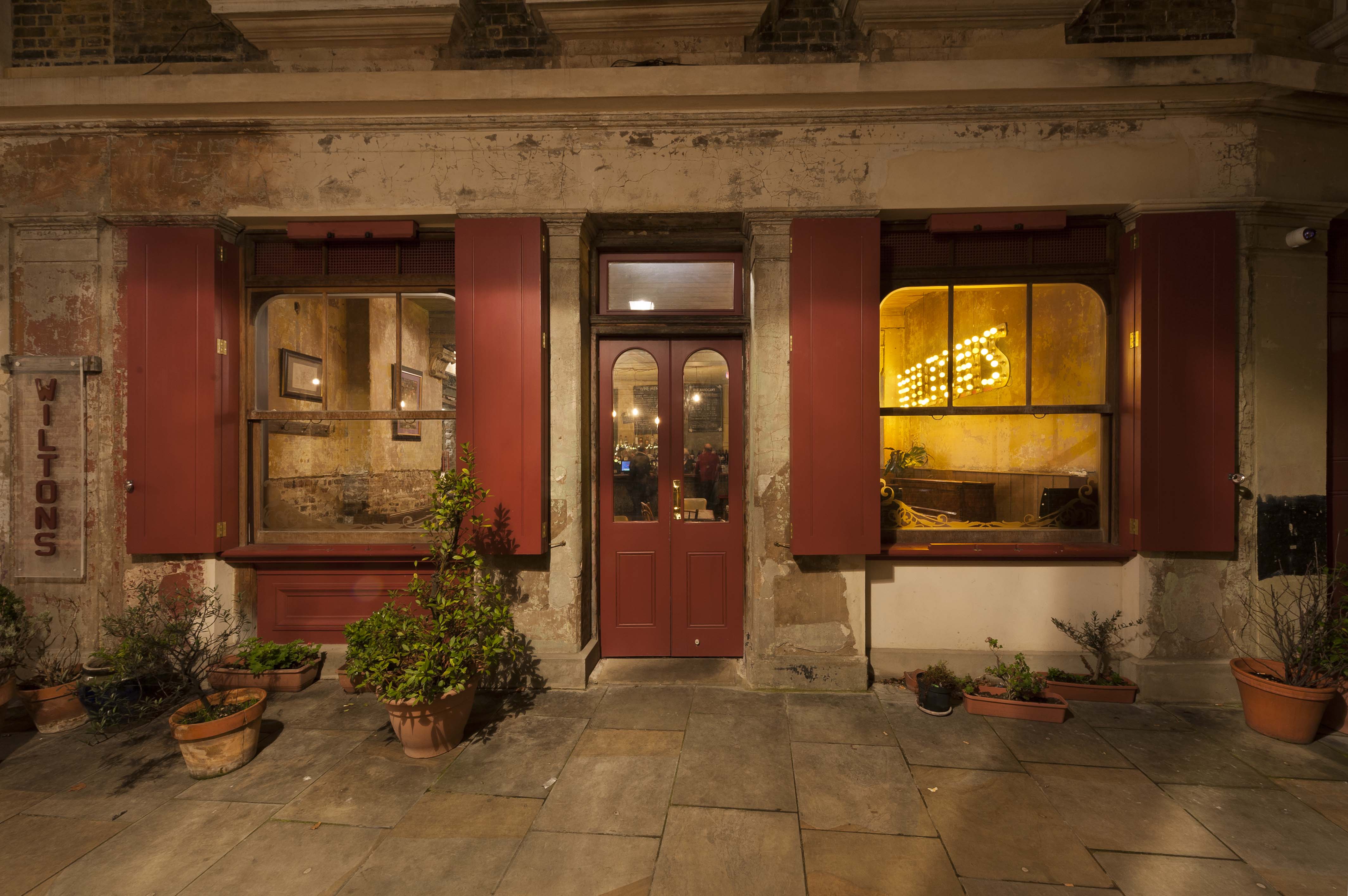
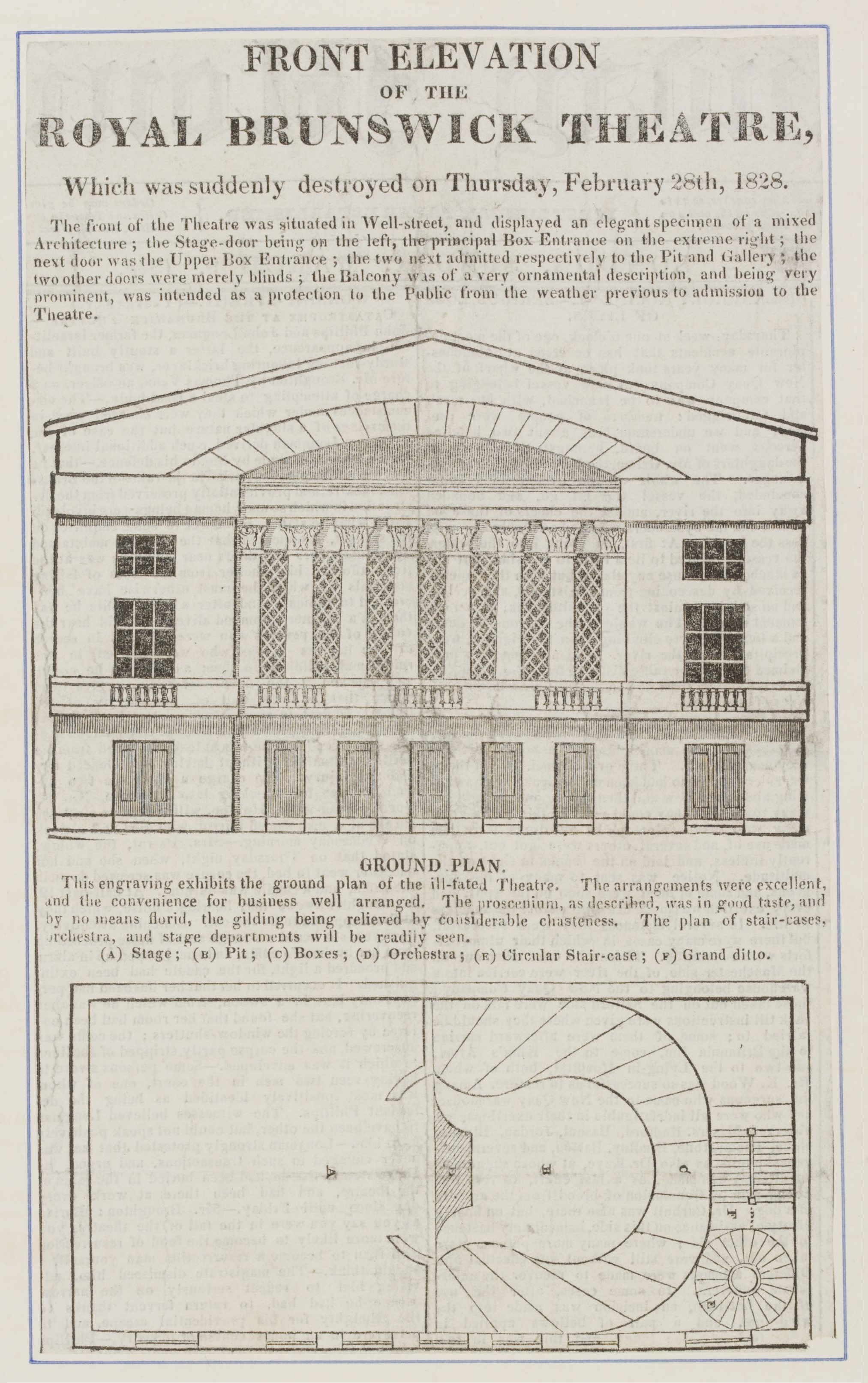
"description": "This is the Royal Brunswick Theatre, which collapsed during a performance shortly after opening in 1828. On its site was erected the Brunswick Maritime Establishment. One of the people who came running to help rescue the survivors was George 'Bosun' Smith, who had the idea for the Brunswick Maritime Establishment, but wanted somewhere to put it. There are bollards on that side of the road with the monogram RBT in commemoration of the theatre disaster.\n\nFrom the East London Theatre Archive: http://www.elta-project.org/browse.html?recordId=2742",
"copyright": false,
"created": "2017-09-12"
},
{
"id": 1545,
"title": "Wellclose Square from the west in 2019",
"author": {
"id": 27,
"username": "DerekKendall"
},
"feature": {
"id": 1739,
"type": "Feature",
"geometry": {
"type": "MultiPolygon",
"coordinates": [
[
[
[
-0.066601937242699,
51.51029583018458
],
[
-0.066591707248507,
51.51033156155218
],
[
-0.066545305611051,
51.51035690561341
],
[
-0.066198603102223,
51.510392528155435
],
[
-0.065574109139852,
51.51044206147906
],
[
-0.065466692202089,
51.51042614702678
],
[
-0.065392638379111,
51.51036346011576
],
[
-0.06531561677056,
51.50997993556986
],
[
-0.065330072257861,
51.50986949543138
],
[
-0.065384877232455,
51.50984713300441
],
[
-0.066347369900239,
51.5097819610304
],
[
-0.066412309769772,
51.5097922788254
],
[
-0.066466585944749,
51.509827985933335
],
[
-0.066496879035431,
51.50989484609386
],
[
-0.066601937242699,
51.51029583018458
]
],
[
[
-0.06617795318375,
51.51038731673777
],
[
-0.066162776826975,
51.51030567245064
],
[
-0.06588610031897,
51.51032669039412
],
[
-0.065912350489888,
51.51041084290673
],
[
-0.06617795318375,
51.51038731673777
]
],
[
[
-0.06624311370635,
51.51019072010641
],
[
-0.066077627531148,
51.510204269850675
],
[
-0.066069527116146,
51.510170337345684
],
[
-0.06611551384684,
51.51016638639934
],
[
-0.066109726117682,
51.51014703372793
],
[
-0.065814585354416,
51.5101673738921
],
[
-0.065821533323482,
51.51022330153386
],
[
-0.065683910471039,
51.51023360737856
],
[
-0.065657889334494,
51.51008339520407
],
[
-0.065349361164399,
51.51010853754948
],
[
-0.06532938777826,
51.510008209650636
],
[
-0.065633994165545,
51.509987653756085
],
[
-0.065620188745178,
51.50991765971934
],
[
-0.065722948991599,
51.50991121538507
],
[
-0.065716780377172,
51.509880881568165
],
[
-0.065901817537395,
51.50986765480321
],
[
-0.06593178354119,
51.50999605393065
],
[
-0.066038317356042,
51.509988508785376
],
[
-0.066023042932445,
51.50990918839897
],
[
-0.065998737156917,
51.50991111308007
],
[
-0.065980280001972,
51.50981894970597
],
[
-0.066320560006103,
51.50979200375635
],
[
-0.06632996113982,
51.50983401855985
],
[
-0.066268265775343,
51.50983881506029
],
[
-0.066265082872055,
51.50982597208467
],
[
-0.066214609325215,
51.509829790835916
],
[
-0.066234584593038,
51.50993011860635
],
[
-0.066179431061551,
51.509934441553284
],
[
-0.066189455574639,
51.5099837339709
],
[
-0.066197871962622,
51.509983000685985
],
[
-0.066205558541818,
51.510021498909204
],
[
-0.066199016557763,
51.510021972412325
],
[
-0.066209250254486,
51.51006632649741
],
[
-0.066216245469672,
51.51006615116071
],
[
-0.066221862792188,
51.51009851070753
],
[
-0.066214365136205,
51.51009954983773
],
[
-0.066220460291682,
51.51013162657133
],
[
-0.06623170678327,
51.51013006787535
],
[
-0.06624311370635,
51.51019072010641
]
]
]
]
},
"properties": {
"b_number": "",
"b_name": "",
"street": "Wellclose Square",
"address": "Wellclose Square",
"feature_type": "OPEN_SPACE",
"count": 8,
"search_str": "Wellclose Square"
},
"tags": [
"George Wolff",
"Lt Gen Albert Borgard",
"Nicholas Barbon",
"Sir John Parsons"
]
},
"file": "https://surveyoflondon.org/media/uploads/features/1739/SoL%20Whitechapel%20102654.jpg",
"description": "",
"copyright": true,
"created": "2019-03-05"
},
{
"id": 1500,
"title": "Caius Gabriel Cibber's statue of Charity ",
"author": {
"id": 2,
"username": "surveyoflondon"
},
"feature": {
"id": 1399,
"type": "Feature",
"geometry": {
"type": "MultiPolygon",
"coordinates": [
[
[
[
-0.06624311370635,
51.51019072010641
],
[
-0.066077627531148,
51.510204269850675
],
[
-0.066069527116146,
51.510170337345684
],
[
-0.06611551384684,
51.51016638639934
],
[
-0.066109726117682,
51.51014703372793
],
[
-0.065814585354416,
51.5101673738921
],
[
-0.065821533323482,
51.51022330153386
],
[
-0.065683910471039,
51.51023360737856
],
[
-0.065657889334494,
51.51008339520407
],
[
-0.065349361164399,
51.51010853754948
],
[
-0.06532938777826,
51.510008209650636
],
[
-0.065633994165545,
51.509987653756085
],
[
-0.065620188745178,
51.50991765971934
],
[
-0.065722948991599,
51.50991121538507
],
[
-0.065716780377172,
51.509880881568165
],
[
-0.065901817537395,
51.50986765480321
],
[
-0.06593178354119,
51.50999605393065
],
[
-0.066038317356042,
51.509988508785376
],
[
-0.066023042932445,
51.50990918839897
],
[
-0.065998737156917,
51.50991111308007
],
[
-0.065980280001972,
51.50981894970597
],
[
-0.066320560006103,
51.50979200375635
],
[
-0.06632996113982,
51.50983401855985
],
[
-0.066268265775343,
51.50983881506029
],
[
-0.066265082872055,
51.50982597208467
],
[
-0.066214609325215,
51.509829790835916
],
[
-0.066234584593038,
51.50993011860635
],
[
-0.066179431061551,
51.509934441553284
],
[
-0.066189455574639,
51.5099837339709
],
[
-0.066197871962622,
51.509983000685985
],
[
-0.066205558541818,
51.510021498909204
],
[
-0.066199016557763,
51.510021972412325
],
[
-0.066209250254486,
51.51006632649741
],
[
-0.066216245469672,
51.51006615116071
],
[
-0.066221862792188,
51.51009851070753
],
[
-0.066214365136205,
51.51009954983773
],
[
-0.066220460291682,
51.51013162657133
],
[
-0.06623170678327,
51.51013006787535
],
[
-0.06624311370635,
51.51019072010641
]
]
]
]
},
"properties": {
"b_number": "",
"b_name": "St Paul's School",
"street": "Wellclose Square",
"address": "St Paul's School, Wellclose Square",
"feature_type": "WHITECHAPEL_BUILDING",
"count": 22,
"search_str": "St Paul's School"
},
"tags": [
"Rev. Dan Greatorex",
"Thomas F. Ford and Partners",
"Wilby & Burnett"
]
},
"file": "https://surveyoflondon.org/media/uploads/features/1399/Charity%20from%20Danish%20Church%2C%20Wellclose%20Square.jpg",
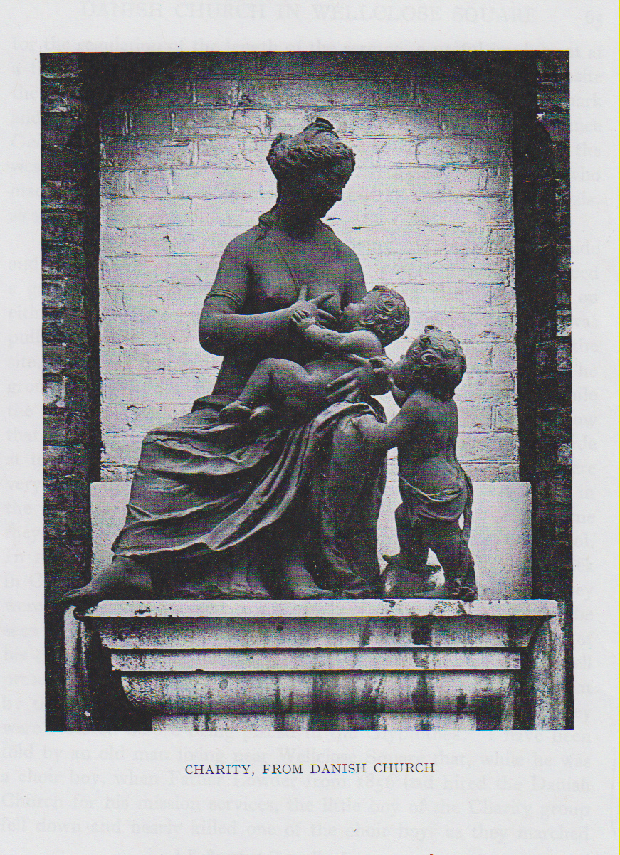
"description": "This statue was made for the west front of Wellclose Square's Danish-Norwegian Church in the 1690s. It was retained when the church was demolished and replaced by St Paul's Schools, resited to a niche above the west entrances to the schools. It was removed to the Ny Glypothek in Copenhagen in 1908. The image is from Harald Faber, 'Caius Gabriel Cibber, 1630-1700', 1926.",
"copyright": false,
"created": "2019-01-09"
},
{
"id": 552,
"title": "1982 view of Beagle House across Braham Street with Camperdown House being rebuilt next door",
"author": {
"id": 22,
"username": "sarahannmilne"
},
"feature": {
"id": 1699,
"type": "Feature",
"geometry": {
"type": "MultiPolygon",
"coordinates": [
[
[
[
-0.072807065482267,
51.513937850831965
],
[
-0.072596293900515,
51.51368300957728
],
[
-0.072417852397056,
51.51374436072419
],
[
-0.072390288345081,
51.51374115582855
],
[
-0.072239332134844,
51.5137937043139
],
[
-0.072149100181317,
51.513851220073796
],
[
-0.072375372474216,
51.514090936056476
],
[
-0.072807065482267,
51.513937850831965
]
]
]
]
},
"properties": {
"b_number": "6",
"b_name": "Camperdown House, 6 Braham Street",
"street": "Braham Street",
"address": "Camperdown House, 6 Braham Street",
"feature_type": "WHITECHAPEL_BUILDING",
"count": 9,
"search_str": "Camperdown House, 6 Braham Street"
},
"tags": []
},
"file": "https://surveyoflondon.org/media/uploads/features/1699/1982.%20%20Rebuilding%20Camperdown%20House%20next%20door.jpg",
"description": "Photograph courtesy of Richard Mellor",
"copyright": false,
"created": "2017-04-25"
},
{
"id": 1184,
"title": "Wilton's Music Hall in early 2018",
"author": {
"id": 27,
"username": "DerekKendall"
},
"feature": {
"id": 1392,
"type": "Feature",
"geometry": {
"type": "MultiPolygon",
"coordinates": [
[
[
[
-0.066897382560978,
51.51047185184401
],
[
-0.066897150320887,
51.510543358461234
],
[
-0.066964310871808,
51.51054939761258
],
[
-0.067031736648758,
51.51055546057313
],
[
-0.067033159620775,
51.51054385631446
],
[
-0.067124985785421,
51.51055249759738
],
[
-0.067119646867151,
51.510573278551
],
[
-0.067097006082147,
51.51057630354935
],
[
-0.067064204301052,
51.510690877240464
],
[
-0.066813595729658,
51.51071232706844
],
[
-0.066808845661517,
51.510692481646345
],
[
-0.066750873450789,
51.51069733978511
],
[
-0.066731248551372,
51.51054469318253
],
[
-0.066802206282857,
51.51054121190127
],
[
-0.066805453245557,
51.51046452251118
],
[
-0.066897382560978,
51.51047185184401
]
]
]
]
},
"properties": {
"b_number": "1",
"b_name": "Wilton's Music Hall",
"street": "Graces Alley",
"address": "Wilton's Music Hall, 1 Graces Alley",
"feature_type": "WHITECHAPEL_BUILDING",
"count": 23,
"search_str": "Wilton's Music Hall"
},
"tags": [
"Wilton's Music Hall"
]
},
"file": "https://surveyoflondon.org/media/uploads/features/1392/SoL%20Whitechapel%20101803.jpg",
"description": "",
"copyright": true,
"created": "2018-03-05"
},
{
"id": 1185,
"title": "Wilton's Music Hall in early 2018, from the west",
"author": {
"id": 27,
"username": "DerekKendall"
},
"feature": {
"id": 1392,
"type": "Feature",
"geometry": {
"type": "MultiPolygon",
"coordinates": [
[
[
[
-0.066897382560978,
51.51047185184401
],
[
-0.066897150320887,
51.510543358461234
],
[
-0.066964310871808,
51.51054939761258
],
[
-0.067031736648758,
51.51055546057313
],
[
-0.067033159620775,
51.51054385631446
],
[
-0.067124985785421,
51.51055249759738
],
[
-0.067119646867151,
51.510573278551
],
[
-0.067097006082147,
51.51057630354935
],
[
-0.067064204301052,
51.510690877240464
],
[
-0.066813595729658,
51.51071232706844
],
[
-0.066808845661517,
51.510692481646345
],
[
-0.066750873450789,
51.51069733978511
],
[
-0.066731248551372,
51.51054469318253
],
[
-0.066802206282857,
51.51054121190127
],
[
-0.066805453245557,
51.51046452251118
],
[
-0.066897382560978,
51.51047185184401
]
]
]
]
},
"properties": {
"b_number": "1",
"b_name": "Wilton's Music Hall",
"street": "Graces Alley",
"address": "Wilton's Music Hall, 1 Graces Alley",
"feature_type": "WHITECHAPEL_BUILDING",
"count": 23,
"search_str": "Wilton's Music Hall"
},
"tags": [
"Wilton's Music Hall"
]
},
"file": "https://surveyoflondon.org/media/uploads/features/1392/SoL%20Whitechapel%20101804.jpg",
"description": "",
"copyright": true,
"created": "2018-03-05"
},
{
"id": 1494,
"title": "52 to 72 Middlesex Street",
"author": {
"id": 27,
"username": "DerekKendall"
},
"feature": {
"id": 328,
"type": "Feature",
"geometry": {
"type": "MultiPolygon",
"coordinates": [
[
[
[
-0.076188584615496,
51.516231715246875
],
[
-0.076163758093209,
51.51620775818292
],
[
-0.076236728804259,
51.51616902092471
],
[
-0.076264094750682,
51.516187017102794
],
[
-0.076256723134832,
51.516196739797564
],
[
-0.076188584615496,
51.516231715246875
]
]
]
]
},
"properties": {
"b_number": "72",
"b_name": "72 Middlesex Street, London E1 7EZ",
"street": "Middlesex Street",
"address": "72 Middlesex Street",
"feature_type": "WHITECHAPEL_BUILDING",
"count": 6,
"search_str": "72 Middlesex Street, London E1 7EZ"
},
"tags": []
},
"file": "https://surveyoflondon.org/media/uploads/features/328/SoL%20Whitechapel%20100892.jpg",
"description": "View south of Nos 52 to 72 Middlesex Street, June 2017",
"copyright": true,
"created": "2019-01-07"
},
{
"id": 1496,
"title": "Whitechapel boundary marker ",
"author": {
"id": 27,
"username": "DerekKendall"
},
"feature": {
"id": 328,
"type": "Feature",
"geometry": {
"type": "MultiPolygon",
"coordinates": [
[
[
[
-0.076188584615496,
51.516231715246875
],
[
-0.076163758093209,
51.51620775818292
],
[
-0.076236728804259,
51.51616902092471
],
[
-0.076264094750682,
51.516187017102794
],
[
-0.076256723134832,
51.516196739797564
],
[
-0.076188584615496,
51.516231715246875
]
]
]
]
},
"properties": {
"b_number": "72",
"b_name": "72 Middlesex Street, London E1 7EZ",
"street": "Middlesex Street",
"address": "72 Middlesex Street",
"feature_type": "WHITECHAPEL_BUILDING",
"count": 6,
"search_str": "72 Middlesex Street, London E1 7EZ"
},
"tags": []
},
"file": "https://surveyoflondon.org/media/uploads/features/328/SoL%20Whitechapel%20100888.jpg",
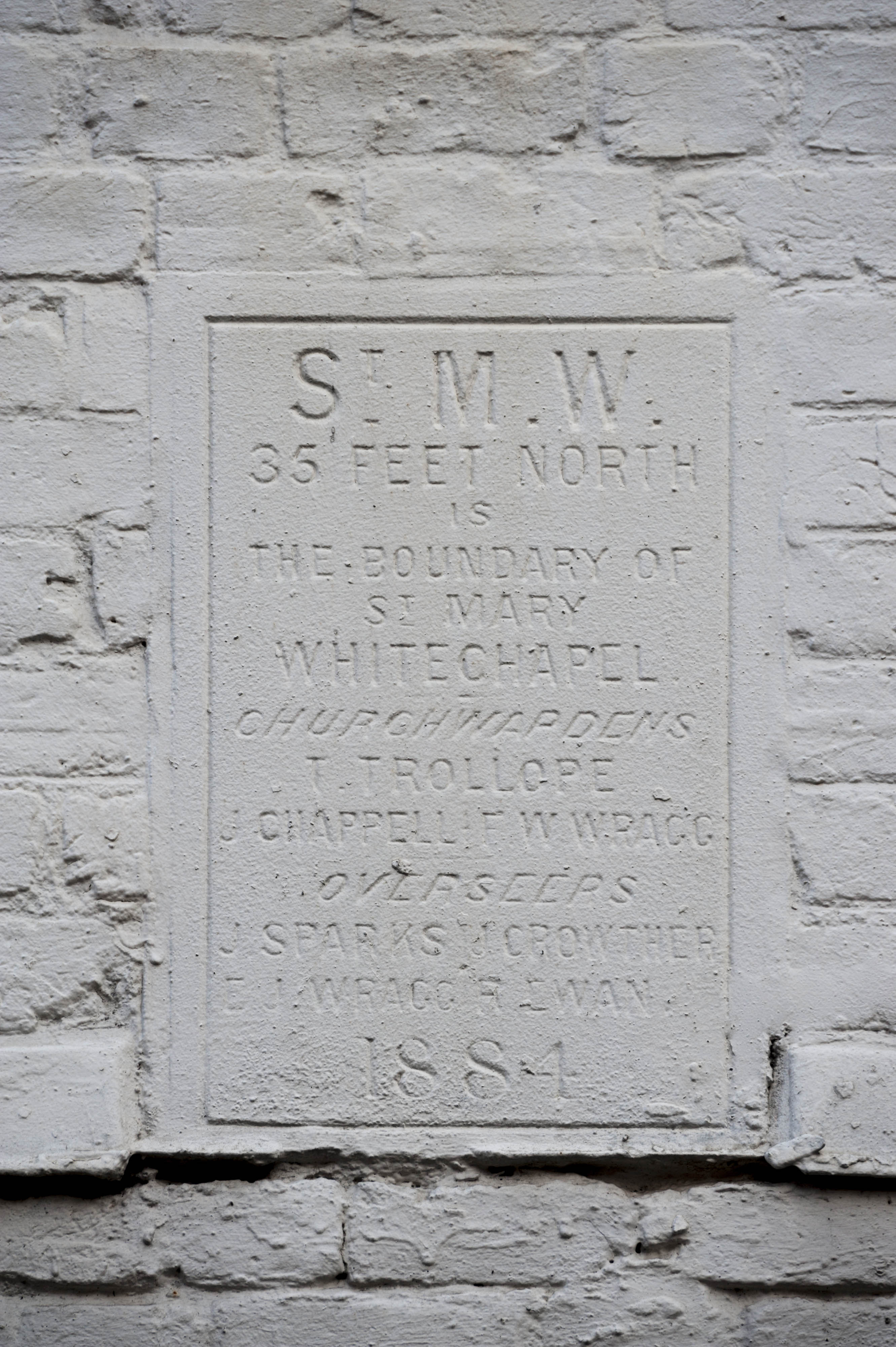
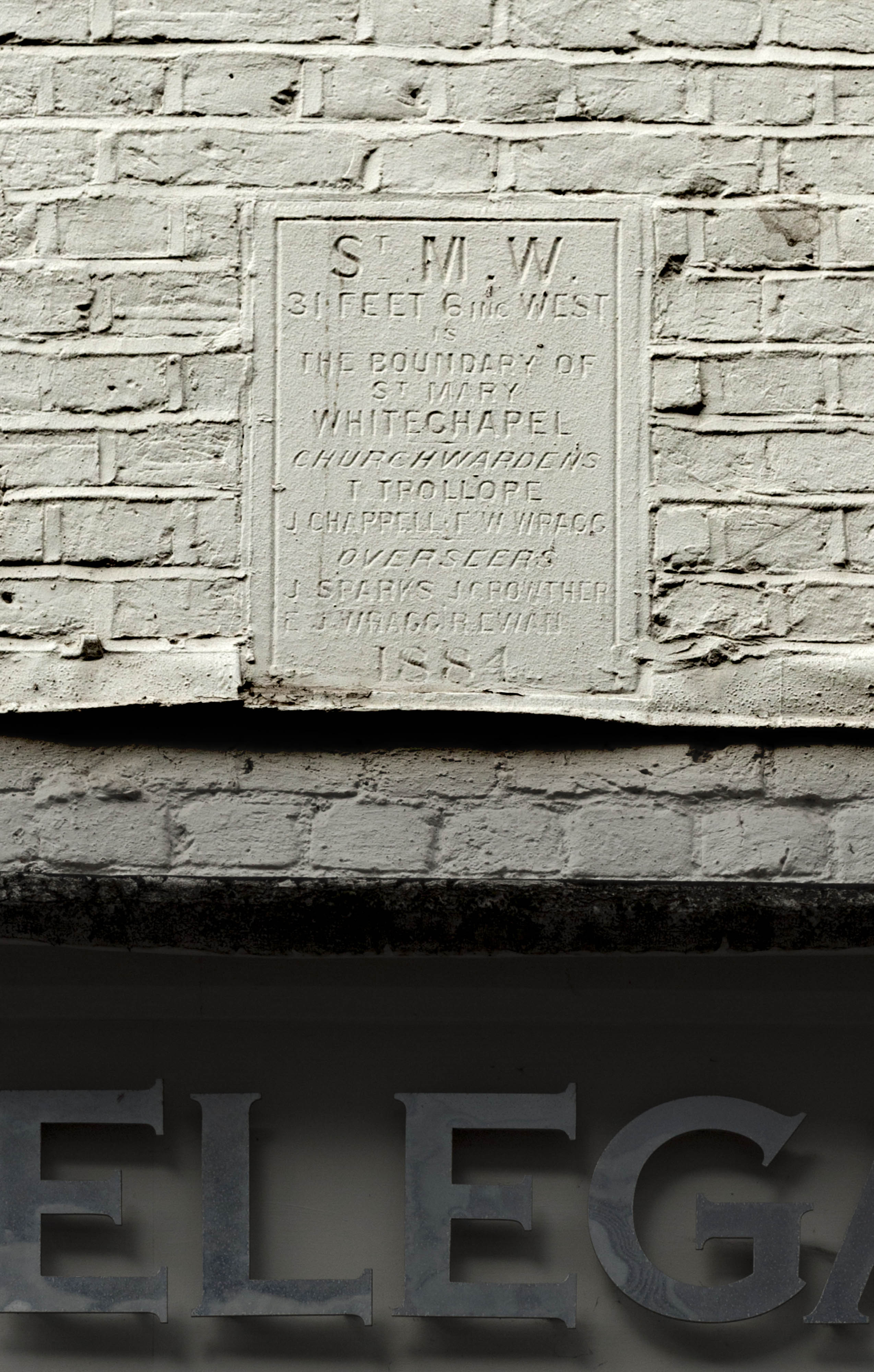
"description": "Plaque of 1884 marking the north boundary of Whitechapel parish, on the Wentworth Street frontage of 72 Middlesex Street.",
"copyright": true,
"created": "2019-01-07"
},
{
"id": 1497,
"title": "Whitechapel parish boundary marker",
"author": {
"id": 27,
"username": "DerekKendall"
},
"feature": {
"id": 328,
"type": "Feature",
"geometry": {
"type": "MultiPolygon",
"coordinates": [
[
[
[
-0.076188584615496,
51.516231715246875
],
[
-0.076163758093209,
51.51620775818292
],
[
-0.076236728804259,
51.51616902092471
],
[
-0.076264094750682,
51.516187017102794
],
[
-0.076256723134832,
51.516196739797564
],
[
-0.076188584615496,
51.516231715246875
]
]
]
]
},
"properties": {
"b_number": "72",
"b_name": "72 Middlesex Street, London E1 7EZ",
"street": "Middlesex Street",
"address": "72 Middlesex Street",
"feature_type": "WHITECHAPEL_BUILDING",
"count": 6,
"search_str": "72 Middlesex Street, London E1 7EZ"
},
"tags": []
},
"file": "https://surveyoflondon.org/media/uploads/features/328/SoL%20Whitechapel%20100889.jpg",
"description": "Plaque dated 1884 on the west front of 72 Middlesex Street marking the boundary of Whitechapel parish, June 2017",
"copyright": true,
"created": "2019-01-07"
},
{
"id": 530,
"title": "Posner Confectionery, 58 Middlesex Street ",
"author": {
"id": 113,
"username": "gary"
},
"feature": {
"id": 334,
"type": "Feature",
"geometry": {
"type": "MultiPolygon",
"coordinates": [
[
[
[
-0.07604568460029,
51.516032457495
],
[
-0.075955159774211,
51.51607514309964
],
[
-0.075955156767306,
51.516075152270226
],
[
-0.075911157281308,
51.51609349819969
],
[
-0.07585057279873,
51.51603345602048
],
[
-0.075961873347909,
51.51597292993351
],
[
-0.07604568460029,
51.516032457495
]
]
]
]
},
"properties": {
"b_number": "58",
"b_name": "58-60 Middlesex Street, London E1 7EZ",
"street": "Middlesex Street",
"address": "58-60 Middlesex Street",
"feature_type": "WHITECHAPEL_BUILDING",
"count": 5,
"search_str": "58-60 Middlesex Street, London E1 7EZ"
},
"tags": []
},
"file": "https://surveyoflondon.org/media/uploads/features/334/IMG_1090.PNG",
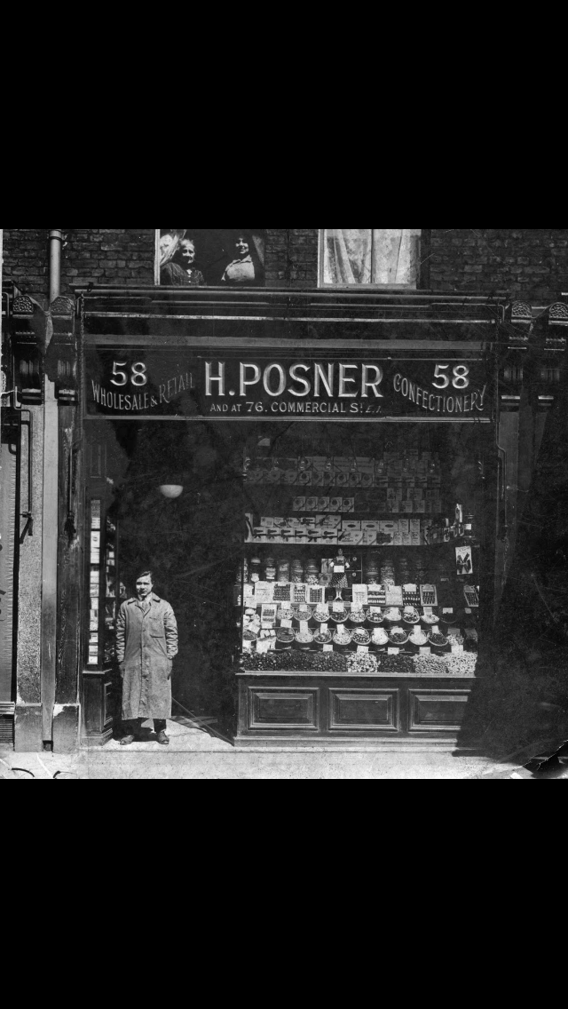
"description": "Abraham Nathan was a boot-maker in the 1871 census and then a confectioner's assistant in the 1881 census. His son-in-law Henry Posner then had the Posner confectioners at 58 Middlesex Street and 76 Commercial Street. I wonder if Abraham's confectioner's job was the catalyst for Henry's business. Henry was my great grandfather. Family folklore is World War 2 and rationing caused the business to close.",
"copyright": false,
"created": "2017-03-26"
},
{
"id": 1511,
"title": "The courtyard of the Dellow Centre",
"author": {
"id": 2,
"username": "surveyoflondon"
},
"feature": {
"id": 364,
"type": "Feature",
"geometry": {
"type": "MultiPolygon",
"coordinates": [
[
[
[
-0.071489806542886,
51.517023172539695
],
[
-0.071243898612021,
51.51660982272529
],
[
-0.071190306454479,
51.516576885746375
],
[
-0.071306299769721,
51.51654960254589
],
[
-0.071326638948875,
51.51652155453997
],
[
-0.071374403242583,
51.5165233420156
],
[
-0.07170710495994,
51.516972518185476
],
[
-0.071689530249958,
51.51699956808665
],
[
-0.071662895989952,
51.51700659921577
],
[
-0.071622347338577,
51.51700294482352
],
[
-0.071489806542886,
51.517023172539695
]
]
]
]
},
"properties": {
"b_number": "82",
"b_name": "The Dellow Centre",
"street": "Wentworth Street",
"address": "Providence Row, The Dellow Centre, 82 Wentworth Street",
"feature_type": "WHITECHAPEL_BUILDING",
"count": 13,
"search_str": "The Dellow Centre"
},
"tags": []
},
"file": "https://surveyoflondon.org/media/uploads/features/364/img_1291_14498429735_o.jpg",
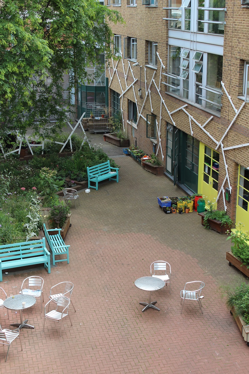
"description": "The courtyard of the Dellow Centre, where the homeless charity Providence Row is located",
"copyright": false,
"created": "2019-01-09"
},
{
"id": 1484,
"title": "1896 - George Yard Mission",
"author": {
"id": 33,
"username": "Charno"
},
"feature": {
"id": 319,
"type": "Feature",
"geometry": {
"type": "MultiPolygon",
"coordinates": [
[
[
[
-0.070587508487069,
51.51582522832629
],
[
-0.070675611333876,
51.51579418730421
],
[
-0.070852952784208,
51.5159819428065
],
[
-0.070751387378099,
51.51601330811343
],
[
-0.070697858527576,
51.51594882337312
],
[
-0.070639428539506,
51.51597016664268
],
[
-0.070598561790314,
51.51592506125996
],
[
-0.070661386641758,
51.51590208444297
],
[
-0.070587508487069,
51.51582522832629
]
]
]
]
},
"properties": {
"b_number": "87",
"b_name": "87 Whitechapel High Street",
"street": "Whitechapel High Street",
"address": "87 Whitechapel High Street",
"feature_type": "WHITECHAPEL_BUILDING",
"count": 3,
"search_str": "87 Whitechapel High Street"
},
"tags": []
},
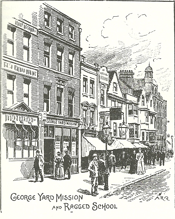
"file": "https://surveyoflondon.org/media/uploads/features/319/1896%20-%20George%20Yard%20Mission.jpg",
"description": "This is the Whitechapel High Street frontage of the George Yard Mission and Ragged School as depicted in Henry Walker's 'East London: Sketches of Christian Work and Workers', published in 1896.",
"copyright": false,
"created": "2019-01-02"
},
{
"id": 1491,
"title": "46 to 48 Middlesex Street",
"author": {
"id": 27,
"username": "DerekKendall"
},
"feature": {
"id": 344,
"type": "Feature",
"geometry": {
"type": "MultiPolygon",
"coordinates": [
[
[
[
-0.075433693659429,
51.51582613468046
],
[
-0.075597153037604,
51.51572213127909
],
[
-0.075597155713587,
51.51572212886487
],
[
-0.075659062914062,
51.515761259453065
],
[
-0.075659057703334,
51.515761260447185
],
[
-0.075490206071596,
51.515861855458034
],
[
-0.075433693659429,
51.51582613468046
]
]
]
]
},
"properties": {
"b_number": "48 and 48a",
"b_name": "48 and 48a Middlesex Street",
"street": "Middlesex Street",
"address": "48 Middlesex Street and The Lofthouse 48a Middlesex Street",
"feature_type": "WHITECHAPEL_BUILDING",
"count": 4,
"search_str": "48 and 48a Middlesex Street"
},
"tags": []
},
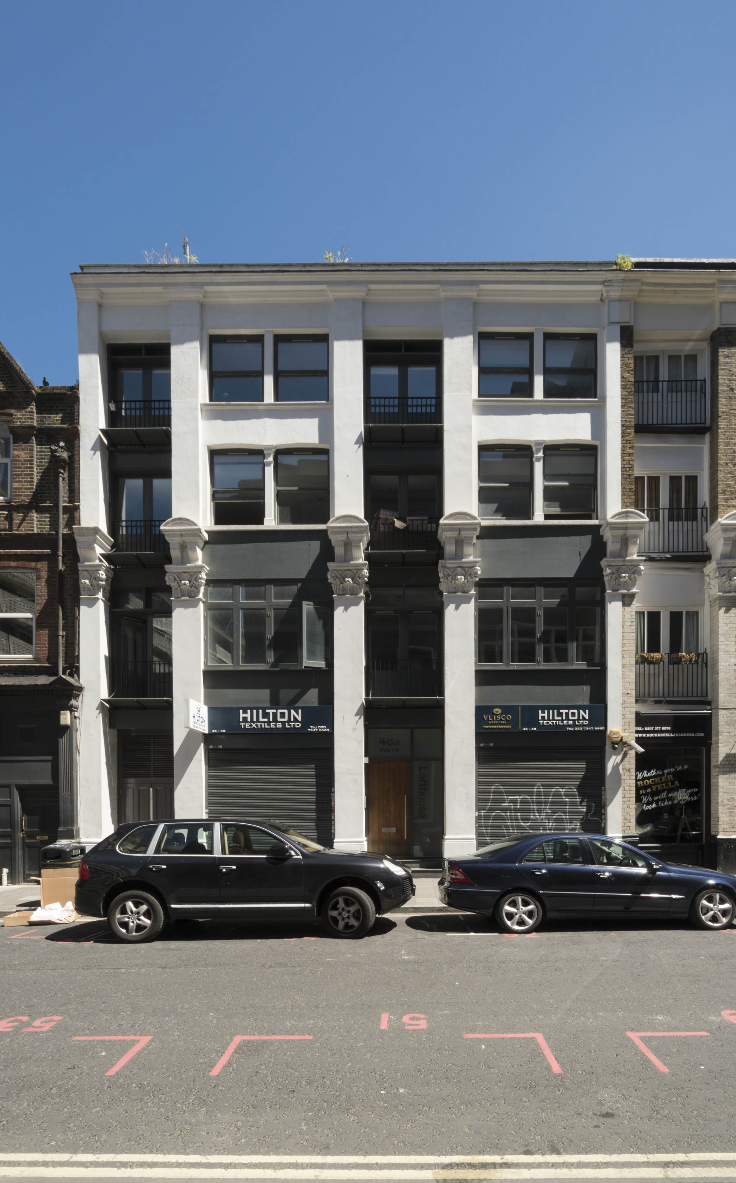
"file": "https://surveyoflondon.org/media/uploads/features/344/SoL%20Whitechapel%20100921.jpg",
"description": "46 and 48 Middlesex Street in June 2017",
"copyright": true,
"created": "2019-01-07"
},
{
"id": 1492,
"title": "View south of 38 to 48 Middlesex Street",
"author": {
"id": 27,
"username": "DerekKendall"
},
"feature": {
"id": 343,
"type": "Feature",
"geometry": {
"type": "MultiPolygon",
"coordinates": [
[
[
[
-0.075597155713587,
51.51572212886487
],
[
-0.075597153037604,
51.51572213127909
],
[
-0.075433693659429,
51.51582613468046
],
[
-0.075378851164837,
51.515790145169014
],
[
-0.07554538563307,
51.51568940579412
],
[
-0.075597155713587,
51.51572212886487
]
]
]
]
},
"properties": {
"b_number": "46 ",
"b_name": "46 Middlesex Street",
"street": "Middlesex Street",
"address": "46 Middlesex Street, London E1 7EX",
"feature_type": "WHITECHAPEL_BUILDING",
"count": 3,
"search_str": "46 Middlesex Street"
},
"tags": []
},
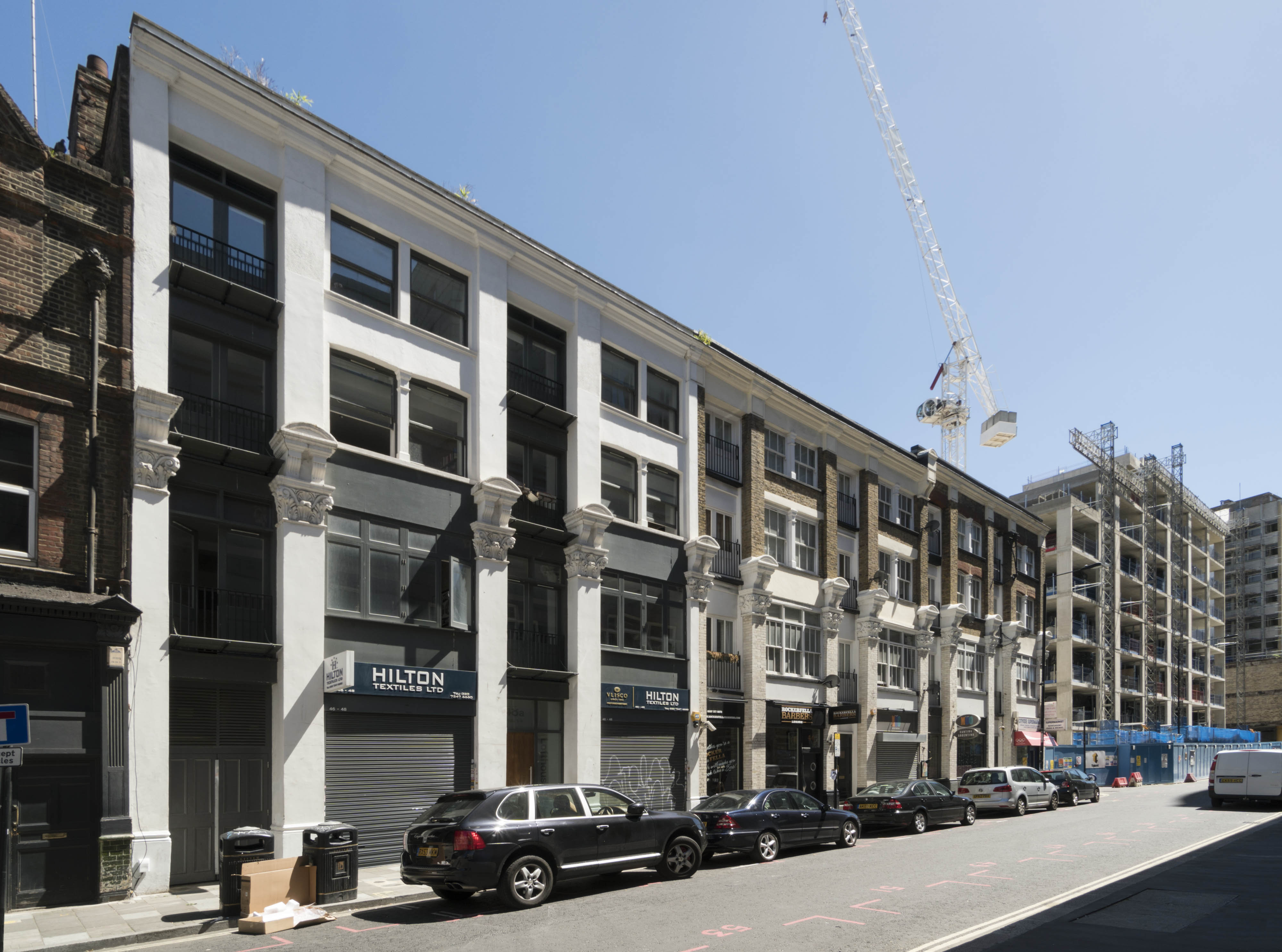
"file": "https://surveyoflondon.org/media/uploads/features/343/SoL%20Whitechapel%20100923.jpg",
"description": "View south form The Bell of the warehouses at 38 to 48 Middlesex Street and the Travelodge on the site of Cromlech House under construction, June 2017",
"copyright": true,
"created": "2019-01-07"
},
{
"id": 1493,
"title": "38 to 44 Middlesex Street",
"author": {
"id": 27,
"username": "DerekKendall"
},
"feature": {
"id": 345,
"type": "Feature",
"geometry": {
"type": "MultiPolygon",
"coordinates": [
[
[
[
-0.07554538563307,
51.51568940579412
],
[
-0.075378851164838,
51.515790145169035
],
[
-0.075315270715817,
51.515752181656595
],
[
-0.075480009767254,
51.51564957127818
],
[
-0.07554538563307,
51.51568940579412
]
]
]
]
},
"properties": {
"b_number": "44",
"b_name": "44 Middlesex Street",
"street": "Middlesex Street",
"address": "44 Middlesex Street",
"feature_type": "WHITECHAPEL_BUILDING",
"count": 4,
"search_str": "44 Middlesex Street"
},
"tags": []
},
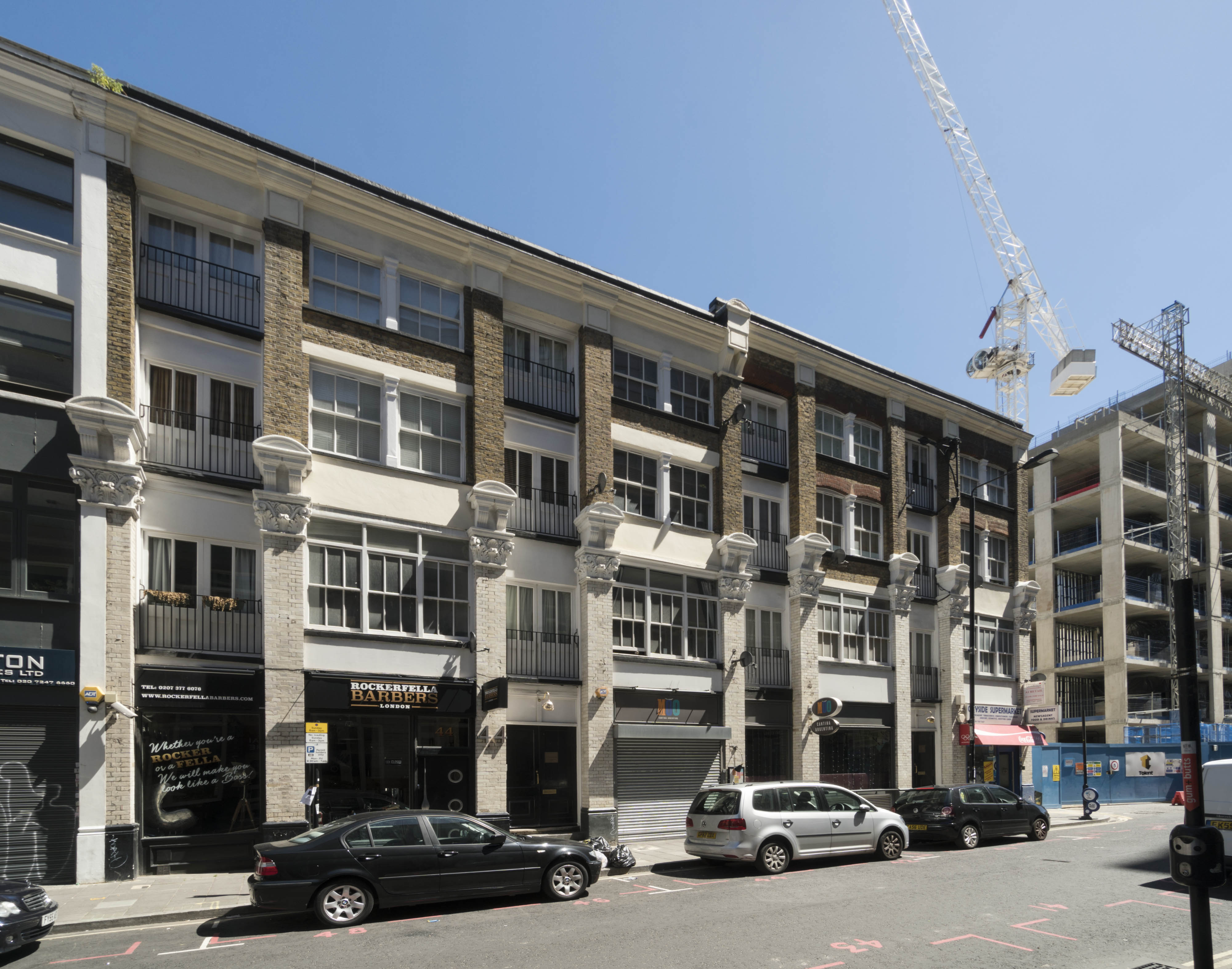
"file": "https://surveyoflondon.org/media/uploads/features/345/SoL%20Whitechapel%20100924.jpg",
"description": "View south of the warehouses at 38 to 44 Middlesex Street",
"copyright": true,
"created": "2019-01-07"
},
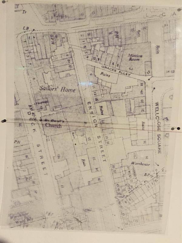
{
"id": 928,
"title": "Map showing the Rio club on Grace's Alley and Ensign Street, before demolition",
"author": {
"id": 197,
"username": "numbi"
},
"feature": {
"id": 1395,
"type": "Feature",
"geometry": {
"type": "MultiPolygon",
"coordinates": [
[
[
[
-0.06734277723579,
51.5101408267643
],
[
-0.066910949136799,
51.510217428527255
],
[
-0.066795977317392,
51.50998414164829
],
[
-0.066852430868868,
51.50997111905564
],
[
-0.066833669508271,
51.50993011276243
],
[
-0.066709688224837,
51.50995364978504
],
[
-0.066597753455944,
51.50973669156566
],
[
-0.067039183086463,
51.50965327261519
],
[
-0.067087140764219,
51.50975289871178
],
[
-0.067115318173266,
51.50974754930748
],
[
-0.067147894414189,
51.50981436423853
],
[
-0.067117953240777,
51.50981735903555
],
[
-0.067140193085813,
51.50986423647582
],
[
-0.067209730295633,
51.509850266595954
],
[
-0.06734277723579,
51.5101408267643
]
]
]
]
},
"properties": {
"b_number": "",
"b_name": "Shapla Primary School",
"street": "Wellclose Square",
"address": "Shapla Primary School",
"feature_type": "WHITECHAPEL_BUILDING",
"count": 11,
"search_str": "Shapla Primary School"
},
"tags": []
},
"file": "https://surveyoflondon.org/media/uploads/features/1395/tumblr_nt1296fb9e1uy4feqo6_1280.jpg",
"description": "Rio Cafè/Club a forgotten landmark Building, that shared Graces Alley with Wilton's Music Hall, what used to be a Somali Cafe. Rio Cafe was a point of gathering, a hangout place for the Somali Seamen who worked in the London Docks. The Cafe was in existence during the 50s and 60s. ",
"copyright": false,
"created": "2017-10-06"
},
{
"id": 1588,
"title": "2-10 Whitechurch Lane from the southwest in 2019",
"author": {
"id": 27,
"username": "DerekKendall"
},
"feature": {
"id": 159,
"type": "Feature",
"geometry": {
"type": "MultiPolygon",
"coordinates": [
[
[
[
-0.069035200140217,
51.51571155031097
],
[
-0.068810248810689,
51.51579556643765
],
[
-0.068782546831716,
51.51576529162323
],
[
-0.068817251819231,
51.51574609699002
],
[
-0.068924168772787,
51.51570878172686
],
[
-0.068920705015919,
51.51570534703247
],
[
-0.069008419422413,
51.515675274067185
],
[
-0.069035200140217,
51.51571155031097
]
]
]
]
},
"properties": {
"b_number": "10",
"b_name": "",
"street": "White Church Lane",
"address": "10 White Church Lane",
"feature_type": "WHITECHAPEL_BUILDING",
"count": 4,
"search_str": "10 White Church Lane"
},
"tags": []
},
"file": "https://surveyoflondon.org/media/uploads/features/159/SoL%20Whitechapel%20102698.jpg",
"description": "",
"copyright": true,
"created": "2019-04-30"
},
{
"id": 1646,
"title": "Capitol House, Leman Street elevation, March 2018",
"author": {
"id": 27,
"username": "DerekKendall"
},
"feature": {
"id": 91,
"type": "Feature",
"geometry": {
"type": "MultiPolygon",
"coordinates": [
[
[
[
-0.07028332473823,
51.51315838751862
],
[
-0.070412526360238,
51.513121210909055
],
[
-0.070434842793584,
51.51315160862411
],
[
-0.070306484946654,
51.513189629390844
],
[
-0.07028332473823,
51.51315838751862
]
]
]
]
},
"properties": {
"b_number": "60–62",
"b_name": "Capitol House",
"street": "Leman Street",
"address": "Capitol House, 60–62 Leman Street",
"feature_type": "WHITECHAPEL_BUILDING",
"count": 2,
"search_str": "Capitol House"
},
"tags": []
},
"file": "https://surveyoflondon.org/media/uploads/features/91/SoL%20Whitechapel%20101960_xJCXrtI.jpg",
"description": "",
"copyright": false,
"created": "2019-08-19"
},
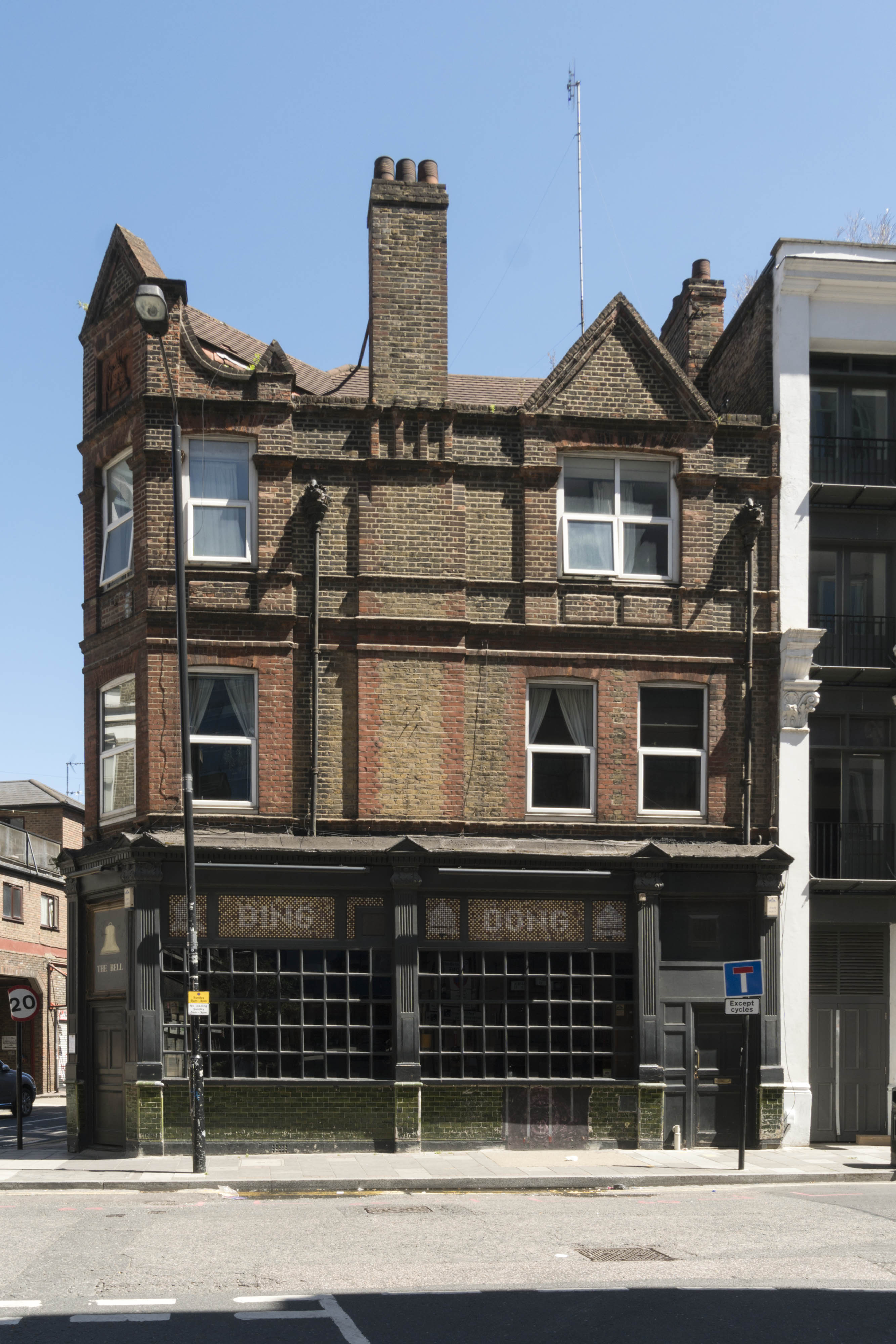
{
"id": 1485,
"title": "The Bell, west side, June 2017",
"author": {
"id": 27,
"username": "DerekKendall"
},
"feature": {
"id": 342,
"type": "Feature",
"geometry": {
"type": "MultiPolygon",
"coordinates": [
[
[
[
-0.075490206071596,
51.515861855458034
],
[
-0.075659057703334,
51.515761260447185
],
[
-0.075659062914062,
51.515761259453065
],
[
-0.075749282153509,
51.51581828564512
],
[
-0.075749034035063,
51.515842125205815
],
[
-0.075527961139716,
51.51590355994891
],
[
-0.075479038495002,
51.5158713869675
],
[
-0.075490214155051,
51.515861860567476
],
[
-0.075490206071596,
51.515861855458034
]
]
]
]
},
"properties": {
"b_number": "50",
"b_name": "The Bell, 50 Middlesex Street",
"street": "Middlesex Street",
"address": "The Bell, 50 Middlesex Street",
"feature_type": "WHITECHAPEL_BUILDING",
"count": 10,
"search_str": "The Bell, 50 Middlesex Street"
},
"tags": [
"house",
"public"
]
},
"file": "https://surveyoflondon.org/media/uploads/features/342/SoL%20Whitechapel%20100908.jpg",
"description": "The Bell photographed in June 2017",
"copyright": true,
"created": "2019-01-07"
}
]
}