HTTP 200 OK
Allow: GET, HEAD, OPTIONS
Content-Type: application/json
Vary: Accept
{
"count": 1747,
"next": "https://surveyoflondon.org/api/v1/images/?format=api&page=63",
"previous": "https://surveyoflondon.org/api/v1/images/?format=api&page=61",
"results": [
{
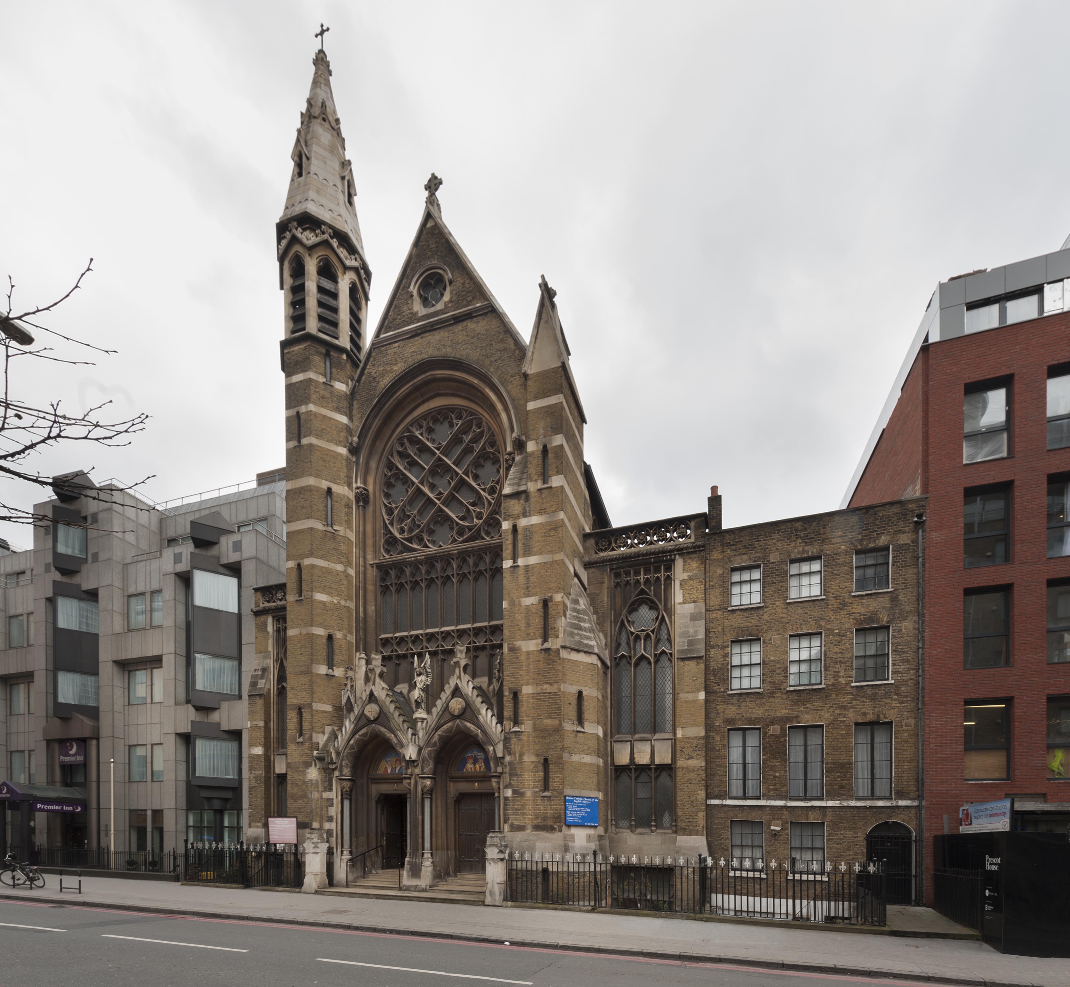
"id": 1231,
"title": "Exterior, March 2018",
"author": {
"id": 27,
"username": "DerekKendall"
},
"feature": {
"id": 1297,
"type": "Feature",
"geometry": {
"type": "MultiPolygon",
"coordinates": [
[
[
[
-0.071935648282288,
51.51134524228436
],
[
-0.071874729442993,
51.51121363108998
],
[
-0.071816144948546,
51.51122339231668
],
[
-0.071776588646252,
51.51120578254433
],
[
-0.071762024560661,
51.51117337877791
],
[
-0.07177649375904,
51.511141452410264
],
[
-0.071834141993347,
51.51113011940239
],
[
-0.071816329795347,
51.51108571239466
],
[
-0.072075019832766,
51.51104549229583
],
[
-0.072193056743033,
51.51130853787665
],
[
-0.072151551976597,
51.51131487321276
],
[
-0.072147312228886,
51.51132649961524
],
[
-0.072142333320455,
51.51133343542439
],
[
-0.072015847069243,
51.5113547481352
],
[
-0.071996105248008,
51.51135617797319
],
[
-0.071982278923131,
51.511350687404345
],
[
-0.071975230627282,
51.51134004502751
],
[
-0.071935648282288,
51.51134524228436
]
]
]
]
},
"properties": {
"b_number": "",
"b_name": "Roman Catholic Church of the English Martyrs",
"street": "Prescot Street",
"address": "Roman Catholic Church of the English Martyrs",
"feature_type": "WHITECHAPEL_BUILDING",
"count": 20,
"search_str": "Roman Catholic Church of the English Martyrs"
},
"tags": []
},
"file": "https://surveyoflondon.org/media/uploads/features/1297/SoL%20Whitechapel%20101885.jpg",
"description": "",
"copyright": true,
"created": "2018-03-27"
},
{
"id": 1643,
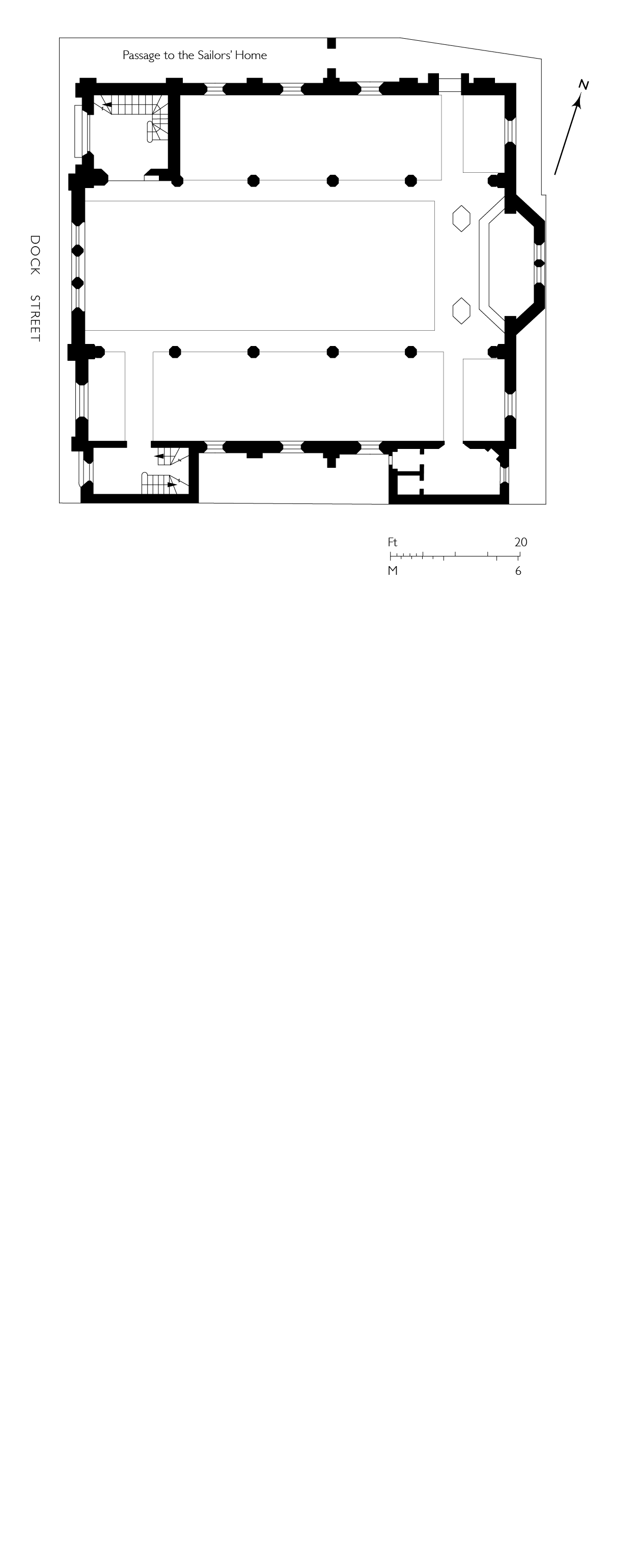
"title": "St Paul, Dock Street, plan as in 1847",
"author": {
"id": 82,
"username": "HelenJones"
},
"feature": {
"id": 1371,
"type": "Feature",
"geometry": {
"type": "MultiPolygon",
"coordinates": [
[
[
[
-0.068057208494737,
51.50994707934026
],
[
-0.068128144074089,
51.510098245489516
],
[
-0.067833383002716,
51.510150364911766
],
[
-0.0678086195768,
51.51009705078618
],
[
-0.067791713048129,
51.51010026052854
],
[
-0.067768418439094,
51.51005627276704
],
[
-0.06778532495294,
51.510053063027875
],
[
-0.06776230081429,
51.510002684478415
],
[
-0.068057208494737,
51.50994707934026
]
]
]
]
},
"properties": {
"b_number": "",
"b_name": "St Paul's Church",
"street": "Dock Street",
"address": "Former Church of St Paul, Dock Street",
"feature_type": "WHITECHAPEL_BUILDING",
"count": 16,
"search_str": "St Paul's Church"
},
"tags": [
"Capt. Robert J. Elliot",
"Henry Roberts",
"James Pennethorne",
"Rev. Dan Greatorex",
"Rev. Joseph Williamson",
"William Cubitt"
]
},
"file": "https://surveyoflondon.org/media/uploads/features/1371/St%20Pauls%20Church%20plan%204%20corrected.jpg",
"description": "",
"copyright": true,
"created": "2019-08-13"
},
{
"id": 1473,
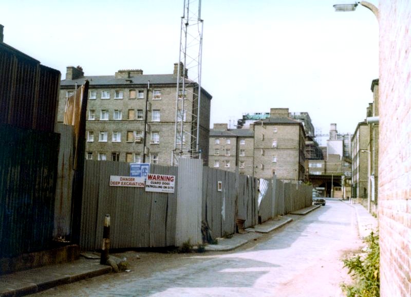
"title": "The construction of the Royal Mint Estate",
"author": {
"id": 153,
"username": "danny"
},
"feature": {
"id": 1726,
"type": "Feature",
"geometry": {
"type": "MultiPolygon",
"coordinates": [
[
[
[
-0.069011382227905,
51.50952453372587
],
[
-0.068991279026173,
51.509481311285114
],
[
-0.068948193310938,
51.50941002367335
],
[
-0.068856478692691,
51.50942811946926
],
[
-0.068909857894843,
51.50954216800575
],
[
-0.069011382227905,
51.50952453372587
]
]
]
]
},
"properties": {
"b_number": "",
"b_name": "",
"street": "",
"address": "Royal Mint Estate",
"feature_type": "WHITECHAPEL_BUILDING",
"count": 10,
"search_str": "Royal Mint Estate"
},
"tags": []
},
"file": "https://surveyoflondon.org/media/uploads/features/1726/JFS%201980.jpg",
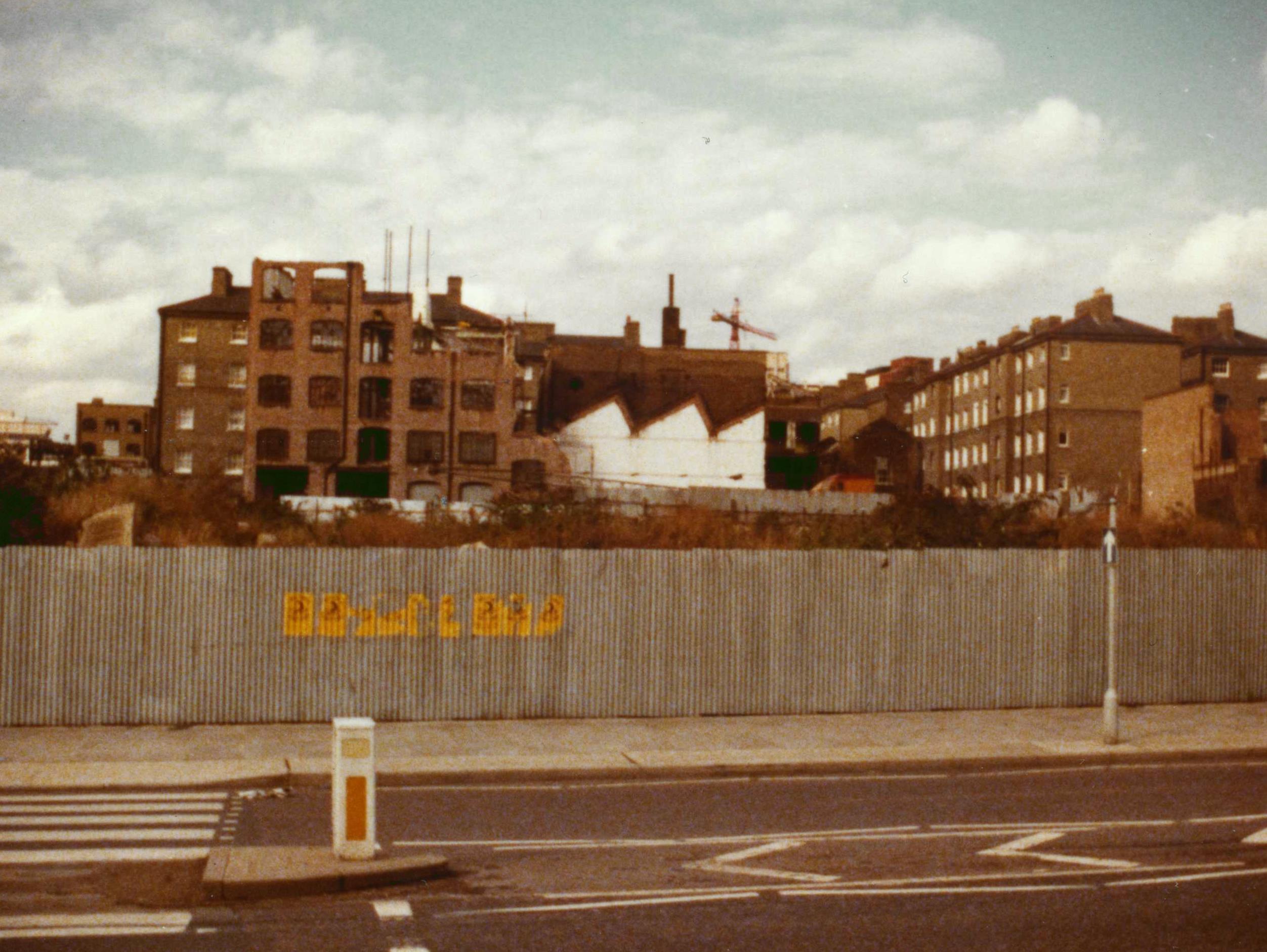
"description": "Photo taken looking north in John Fisher Street as construction of the Royal Mint Estate gets underway circa 1980.",
"copyright": true,
"created": "2018-12-01"
},
{
"id": 1479,
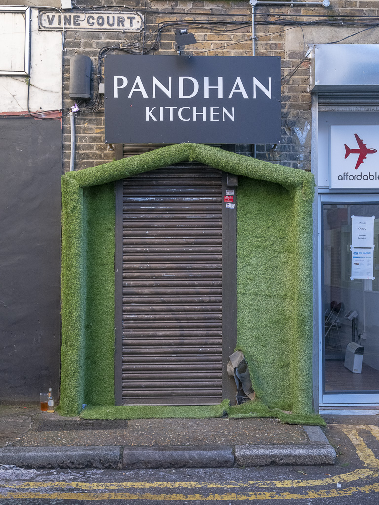
"title": "Vine Court: Padhan Kitchen",
"author": {
"id": 242,
"username": "louisberk"
},
"feature": {
"id": 876,
"type": "Feature",
"geometry": {
"type": "MultiPolygon",
"coordinates": [
[
[
[
-0.063833491375847,
51.517718888199155
],
[
-0.06370812902239,
51.517760003640674
],
[
-0.063497206770844,
51.517514814693946
],
[
-0.06364552630732,
51.51749667516779
],
[
-0.063833491375847,
51.517718888199155
]
]
]
]
},
"properties": {
"b_number": "5-6",
"b_name": "",
"street": "Vine Court",
"address": "5-6 Vine Court",
"feature_type": "WHITECHAPEL_BUILDING",
"count": 2,
"search_str": "5-6 Vine Court"
},
"tags": []
},
"file": "https://surveyoflondon.org/media/uploads/features/876/Louis%20Berk%20Vine%20Court.jpg",
"description": "Close-up of a remaining building in the small alley way behind Whitechapel Road, clearly showing the older style (original?) street sign.",
"copyright": false,
"created": "2018-12-17"
},
{
"id": 1474,
"title": "Royal Mint Estate",
"author": {
"id": 153,
"username": "danny"
},
"feature": {
"id": 1726,
"type": "Feature",
"geometry": {
"type": "MultiPolygon",
"coordinates": [
[
[
[
-0.069011382227905,
51.50952453372587
],
[
-0.068991279026173,
51.509481311285114
],
[
-0.068948193310938,
51.50941002367335
],
[
-0.068856478692691,
51.50942811946926
],
[
-0.068909857894843,
51.50954216800575
],
[
-0.069011382227905,
51.50952453372587
]
]
]
]
},
"properties": {
"b_number": "",
"b_name": "",
"street": "",
"address": "Royal Mint Estate",
"feature_type": "WHITECHAPEL_BUILDING",
"count": 10,
"search_str": "Royal Mint Estate"
},
"tags": []
},
"file": "https://surveyoflondon.org/media/uploads/features/1726/JFS%202.jpg",
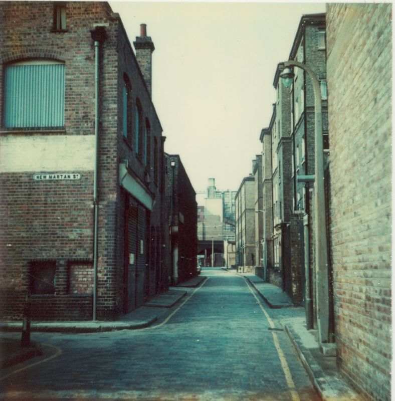
"description": "Photo taken looking north from East Smithfield across the derelict site that was to form part of the new Royal Mint Estate built by the GLC in 1979-1982. In the background can be seen the Peabody Whitechapel Estate in John Fisher Street, and in front, a by then derelict industrial building situated on New Martan Street (off John Fisher Street) and which was obliterated by the new Royal Mint Estate.",
"copyright": true,
"created": "2018-12-01"
},
{
"id": 1475,
"title": "Royal Mint Estate",
"author": {
"id": 153,
"username": "danny"
},
"feature": {
"id": 1726,
"type": "Feature",
"geometry": {
"type": "MultiPolygon",
"coordinates": [
[
[
[
-0.069011382227905,
51.50952453372587
],
[
-0.068991279026173,
51.509481311285114
],
[
-0.068948193310938,
51.50941002367335
],
[
-0.068856478692691,
51.50942811946926
],
[
-0.068909857894843,
51.50954216800575
],
[
-0.069011382227905,
51.50952453372587
]
]
]
]
},
"properties": {
"b_number": "",
"b_name": "",
"street": "",
"address": "Royal Mint Estate",
"feature_type": "WHITECHAPEL_BUILDING",
"count": 10,
"search_str": "Royal Mint Estate"
},
"tags": []
},
"file": "https://surveyoflondon.org/media/uploads/features/1726/New%20Martan%20Street.jpg",
"description": "Old industrial buildings, warehouse on corner and William Douger Tea and Coffee buildings on John Fisher Street and at the junction with New Martan Street which was later obliterated by the construction of the Royal Mint Estate in 1979-1982 by the GLC.",
"copyright": true,
"created": "2018-12-01"
},
{
"id": 1465,
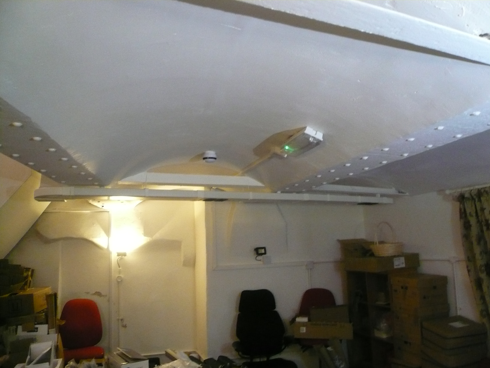
"title": "Jack-arch girder ceiling over basement (air shaft) room to north of ventilation tower",
"author": {
"id": 10,
"username": "PGuillery"
},
"feature": {
"id": 169,
"type": "Feature",
"geometry": {
"type": "MultiPolygon",
"coordinates": [
[
[
[
-0.069651046927799,
51.515906748996194
],
[
-0.069592567052389,
51.51593286484659
],
[
-0.069462353413791,
51.51582917877918
],
[
-0.069513217260896,
51.51581285271919
],
[
-0.069471535482955,
51.51577379234225
],
[
-0.069534270508602,
51.515757354492386
],
[
-0.069599774486383,
51.515845312065174
],
[
-0.069589679654299,
51.51585075075555
],
[
-0.069651046927799,
51.515906748996194
]
]
]
]
},
"properties": {
"b_number": "69",
"b_name": "",
"street": "Whitechapel High Street",
"address": "69 Whitechapel High Street",
"feature_type": "WHITECHAPEL_BUILDING",
"count": 11,
"search_str": "69 Whitechapel High Street"
},
"tags": []
},
"file": "https://surveyoflondon.org/media/uploads/features/169/P1210067.JPG",
"description": "",
"copyright": true,
"created": "2018-11-28"
},
{
"id": 1466,
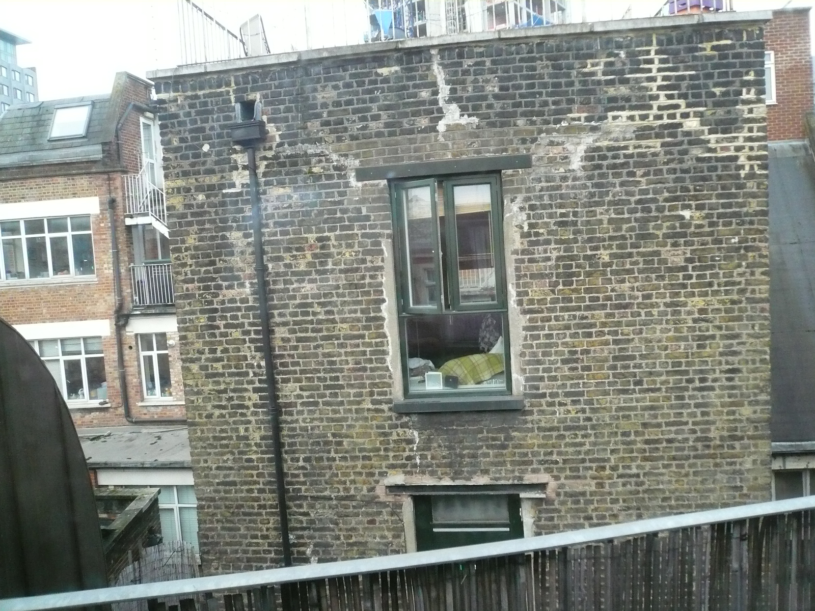
"title": "Top storey of former ventilation tower (9 Whitechurch Passage) from the north",
"author": {
"id": 10,
"username": "PGuillery"
},
"feature": {
"id": 169,
"type": "Feature",
"geometry": {
"type": "MultiPolygon",
"coordinates": [
[
[
[
-0.069651046927799,
51.515906748996194
],
[
-0.069592567052389,
51.51593286484659
],
[
-0.069462353413791,
51.51582917877918
],
[
-0.069513217260896,
51.51581285271919
],
[
-0.069471535482955,
51.51577379234225
],
[
-0.069534270508602,
51.515757354492386
],
[
-0.069599774486383,
51.515845312065174
],
[
-0.069589679654299,
51.51585075075555
],
[
-0.069651046927799,
51.515906748996194
]
]
]
]
},
"properties": {
"b_number": "69",
"b_name": "",
"street": "Whitechapel High Street",
"address": "69 Whitechapel High Street",
"feature_type": "WHITECHAPEL_BUILDING",
"count": 11,
"search_str": "69 Whitechapel High Street"
},
"tags": []
},
"file": "https://surveyoflondon.org/media/uploads/features/169/P1210071.JPG",
"description": "",
"copyright": true,
"created": "2018-11-28"
},
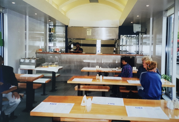
{
"id": 1253,
"title": "Taja restaurant",
"author": {
"id": 18,
"username": "shahedsaleem"
},
"feature": {
"id": 1698,
"type": "Feature",
"geometry": {
"type": "MultiPolygon",
"coordinates": [
[
[
[
-0.062755898137067,
51.51857235799611
],
[
-0.058216859270041,
51.51960039921044
],
[
-0.058148482851386,
51.51948612756745
],
[
-0.061091729886378,
51.51883423152082
],
[
-0.061616259170046,
51.51871888429734
],
[
-0.06270768344222,
51.51847582817058
],
[
-0.062755898137067,
51.51857235799611
]
]
]
]
},
"properties": {
"b_number": "",
"b_name": "",
"street": "Whitechapel Road",
"address": "Whitechapel Market, Whitechapel Road",
"feature_type": "PLACE",
"count": 48,
"search_str": "Whitechapel Market, Whitechapel Road"
},
"tags": []
},
"file": "https://surveyoflondon.org/media/uploads/features/1698/20180513_123537-ed_edited-2.jpg",
"description": "Tanha Quadi's photos of the Taja restaurant, a conversion of and building over the former public lavatories from the early 2000s",
"copyright": false,
"created": "2018-05-15"
},
{
"id": 992,
"title": "1966: Re-instatement of 2nd floor of no 70 about to commence after the 1940 war damage.",
"author": {
"id": 131,
"username": "Tomreed"
},
"feature": {
"id": 169,
"type": "Feature",
"geometry": {
"type": "MultiPolygon",
"coordinates": [
[
[
[
-0.069651046927799,
51.515906748996194
],
[
-0.069592567052389,
51.51593286484659
],
[
-0.069462353413791,
51.51582917877918
],
[
-0.069513217260896,
51.51581285271919
],
[
-0.069471535482955,
51.51577379234225
],
[
-0.069534270508602,
51.515757354492386
],
[
-0.069599774486383,
51.515845312065174
],
[
-0.069589679654299,
51.51585075075555
],
[
-0.069651046927799,
51.515906748996194
]
]
]
]
},
"properties": {
"b_number": "69",
"b_name": "",
"street": "Whitechapel High Street",
"address": "69 Whitechapel High Street",
"feature_type": "WHITECHAPEL_BUILDING",
"count": 11,
"search_str": "69 Whitechapel High Street"
},
"tags": []
},
"file": "https://surveyoflondon.org/media/uploads/features/169/Screen%20Shot%202017-12-20%20at%2015.49.36.png",
"description": "",
"copyright": false,
"created": "2017-12-20"
},
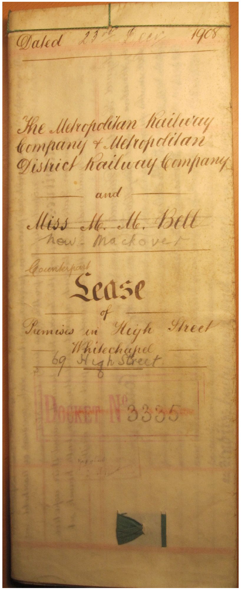
{
"id": 994,
"title": "99 year Lease from 1907 on 69 Whitechapel High Street: ",
"author": {
"id": 131,
"username": "Tomreed"
},
"feature": {
"id": 169,
"type": "Feature",
"geometry": {
"type": "MultiPolygon",
"coordinates": [
[
[
[
-0.069651046927799,
51.515906748996194
],
[
-0.069592567052389,
51.51593286484659
],
[
-0.069462353413791,
51.51582917877918
],
[
-0.069513217260896,
51.51581285271919
],
[
-0.069471535482955,
51.51577379234225
],
[
-0.069534270508602,
51.515757354492386
],
[
-0.069599774486383,
51.515845312065174
],
[
-0.069589679654299,
51.51585075075555
],
[
-0.069651046927799,
51.515906748996194
]
]
]
]
},
"properties": {
"b_number": "69",
"b_name": "",
"street": "Whitechapel High Street",
"address": "69 Whitechapel High Street",
"feature_type": "WHITECHAPEL_BUILDING",
"count": 11,
"search_str": "69 Whitechapel High Street"
},
"tags": []
},
"file": "https://surveyoflondon.org/media/uploads/features/169/Screen%20Shot%202017-12-20%20at%2015.54.03.png",
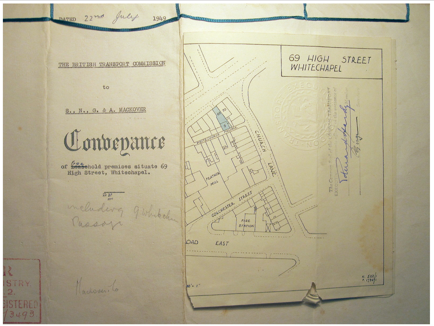
"description": "(including 9 Whitechurch Passage then known as Spectacle Alley). Dated 23.12.1908, between The Metropolitan Railway Company and Malvina Mary Bell. This refers to “the building in the course of erection” which the lessees will complete by 31.12.1909 “in accordance with plans already approved”. This lease was then acquired by Wolf Mackover and converted by his four sons into the Freehold from London Metropolitan Railway in 1949. ",
"copyright": false,
"created": "2017-12-20"
},
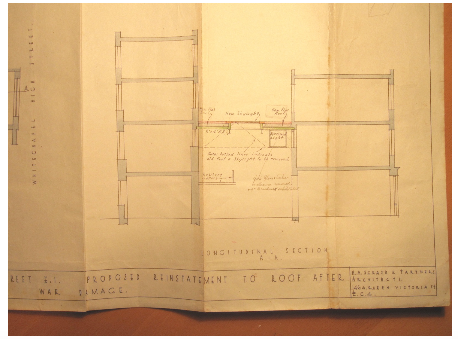
{
"id": 995,
"title": "1942 Section plan for repairs to bomb damage to no 69. ",
"author": {
"id": 131,
"username": "Tomreed"
},
"feature": {
"id": 169,
"type": "Feature",
"geometry": {
"type": "MultiPolygon",
"coordinates": [
[
[
[
-0.069651046927799,
51.515906748996194
],
[
-0.069592567052389,
51.51593286484659
],
[
-0.069462353413791,
51.51582917877918
],
[
-0.069513217260896,
51.51581285271919
],
[
-0.069471535482955,
51.51577379234225
],
[
-0.069534270508602,
51.515757354492386
],
[
-0.069599774486383,
51.515845312065174
],
[
-0.069589679654299,
51.51585075075555
],
[
-0.069651046927799,
51.515906748996194
]
]
]
]
},
"properties": {
"b_number": "69",
"b_name": "",
"street": "Whitechapel High Street",
"address": "69 Whitechapel High Street",
"feature_type": "WHITECHAPEL_BUILDING",
"count": 11,
"search_str": "69 Whitechapel High Street"
},
"tags": []
},
"file": "https://surveyoflondon.org/media/uploads/features/169/Screen%20Shot%202017-12-20%20at%2015.55.44.png",
"description": "",
"copyright": false,
"created": "2017-12-20"
},
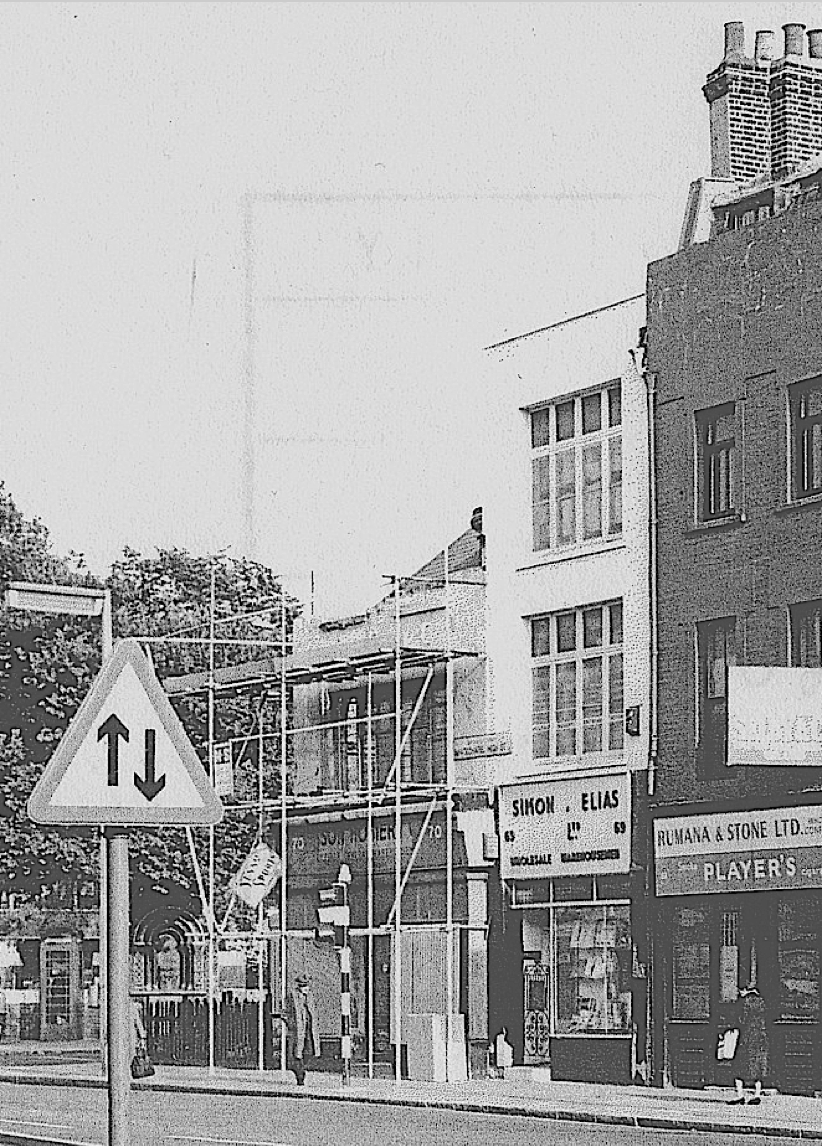
{
"id": 1407,
"title": "Lambeth Street from the south in the early 1970s (photograph by Dan Cruickshank)",
"author": {
"id": 268,
"username": "DanCruickshank"
},
"feature": {
"id": 1007,
"type": "Feature",
"geometry": {
"type": "MultiPolygon",
"coordinates": [
[
[
[
-0.068604481747272,
51.51259519216751
],
[
-0.068394295073252,
51.512662674029954
],
[
-0.068193731130485,
51.51223927149179
],
[
-0.068417624655329,
51.51219797913798
],
[
-0.068604481747272,
51.51259519216751
]
]
]
]
},
"properties": {
"b_number": "1 to 54 ",
"b_name": "1–54 Times Square, Hooper Street",
"street": "Hooper Street",
"address": "1–54 Times Square",
"feature_type": "WHITECHAPEL_BUILDING",
"count": 10,
"search_str": "1–54 Times Square, Hooper Street"
},
"tags": []
},
"file": "https://surveyoflondon.org/media/uploads/features/1007/00410004%20(1).jpg",
"description": "",
"copyright": true,
"created": "2018-11-13"
},
{
"id": 996,
"title": "The acquisition of the freehold of 69 by S, N, G & A Mackover in 1949.",
"author": {
"id": 131,
"username": "Tomreed"
},
"feature": {
"id": 169,
"type": "Feature",
"geometry": {
"type": "MultiPolygon",
"coordinates": [
[
[
[
-0.069651046927799,
51.515906748996194
],
[
-0.069592567052389,
51.51593286484659
],
[
-0.069462353413791,
51.51582917877918
],
[
-0.069513217260896,
51.51581285271919
],
[
-0.069471535482955,
51.51577379234225
],
[
-0.069534270508602,
51.515757354492386
],
[
-0.069599774486383,
51.515845312065174
],
[
-0.069589679654299,
51.51585075075555
],
[
-0.069651046927799,
51.515906748996194
]
]
]
]
},
"properties": {
"b_number": "69",
"b_name": "",
"street": "Whitechapel High Street",
"address": "69 Whitechapel High Street",
"feature_type": "WHITECHAPEL_BUILDING",
"count": 11,
"search_str": "69 Whitechapel High Street"
},
"tags": []
},
"file": "https://surveyoflondon.org/media/uploads/features/169/Screen%20Shot%202017-12-20%20at%2015.56.29.png",
"description": "",
"copyright": false,
"created": "2017-12-20"
},
{
"id": 20,
"title": "Sedgwick Centre",
"author": {
"id": 27,
"username": "DerekKendall"
},
"feature": {
"id": 8,
"type": "Feature",
"geometry": {
"type": "MultiPolygon",
"coordinates": [
[
[
[
-0.073603320060571,
51.51442327236536
],
[
-0.07261601532333,
51.51479023781785
],
[
-0.072264192178305,
51.514410425590924
],
[
-0.073236796882946,
51.514043833466424
],
[
-0.073307790491948,
51.51410595311657
],
[
-0.073389035166878,
51.51407809430392
],
[
-0.073613325753717,
51.514325591848184
],
[
-0.073536413082246,
51.514353078477846
],
[
-0.073603320060571,
51.51442327236536
]
]
]
]
},
"properties": {
"b_number": "10",
"b_name": "The White Chapel Building (former Sedgwick Centre)",
"street": "Whitechapel High Street",
"address": "10 Whitechapel High Street",
"feature_type": "WHITECHAPEL_BUILDING",
"count": 11,
"search_str": "The White Chapel Building (former Sedgwick Centre)"
},
"tags": []
},
"file": "https://surveyoflondon.org/media/uploads/features/8/SoL-Whitechapel100335.jpg",
"description": "Sedgwick Centre from South-West",
"copyright": true,
"created": null
},
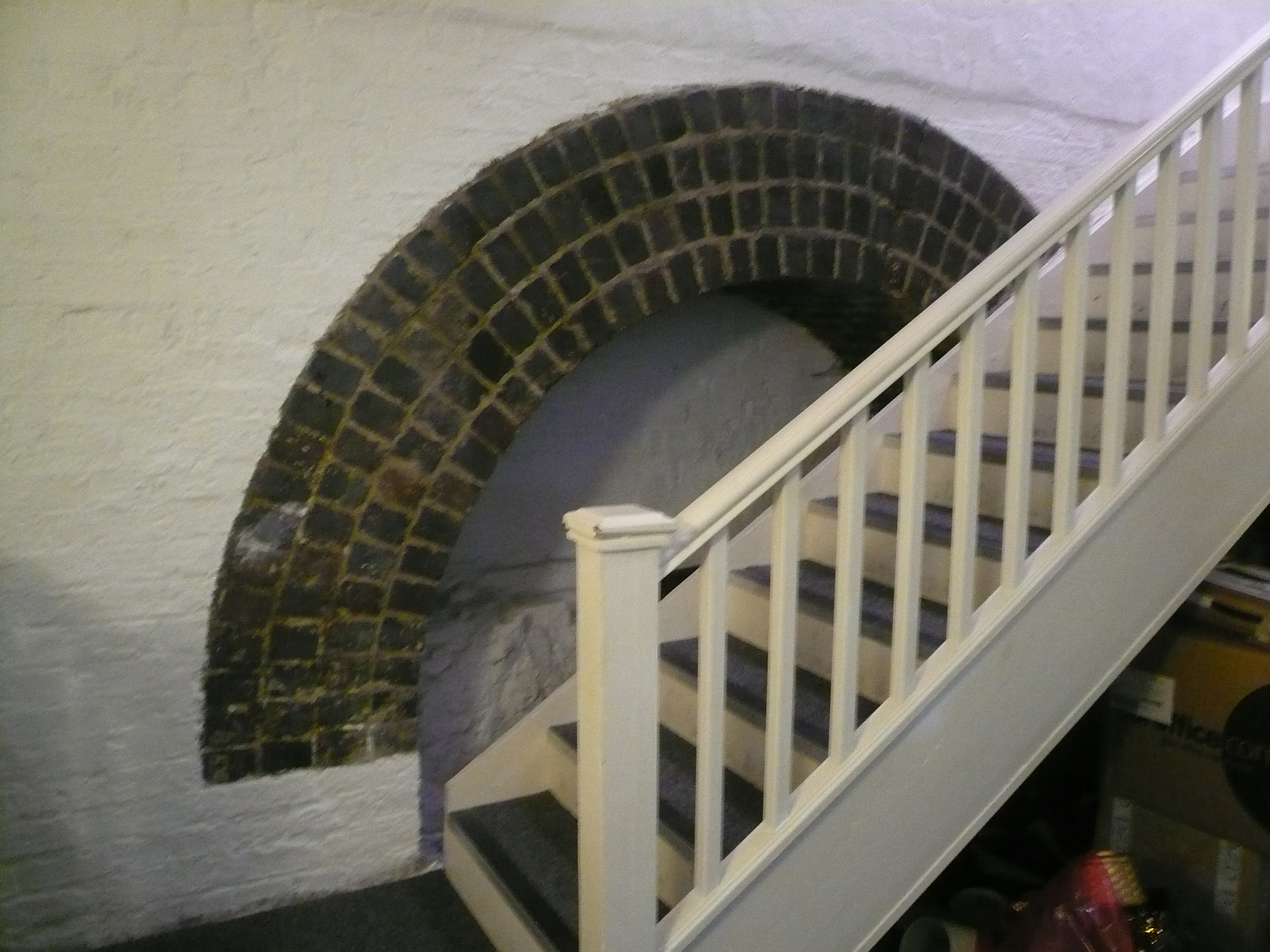
{
"id": 1464,
"title": "basement arch in north wall of former ventilation tower (9 Whitechurch Passage) for air shaft",
"author": {
"id": 10,
"username": "PGuillery"
},
"feature": {
"id": 169,
"type": "Feature",
"geometry": {
"type": "MultiPolygon",
"coordinates": [
[
[
[
-0.069651046927799,
51.515906748996194
],
[
-0.069592567052389,
51.51593286484659
],
[
-0.069462353413791,
51.51582917877918
],
[
-0.069513217260896,
51.51581285271919
],
[
-0.069471535482955,
51.51577379234225
],
[
-0.069534270508602,
51.515757354492386
],
[
-0.069599774486383,
51.515845312065174
],
[
-0.069589679654299,
51.51585075075555
],
[
-0.069651046927799,
51.515906748996194
]
]
]
]
},
"properties": {
"b_number": "69",
"b_name": "",
"street": "Whitechapel High Street",
"address": "69 Whitechapel High Street",
"feature_type": "WHITECHAPEL_BUILDING",
"count": 11,
"search_str": "69 Whitechapel High Street"
},
"tags": []
},
"file": "https://surveyoflondon.org/media/uploads/features/169/P1210068.JPG",
"description": "",
"copyright": true,
"created": "2018-11-28"
},
{
"id": 1180,
"title": "Wilton's Music Hall in early 2018, view along Grace's Alley from the north-west",
"author": {
"id": 27,
"username": "DerekKendall"
},
"feature": {
"id": 1392,
"type": "Feature",
"geometry": {
"type": "MultiPolygon",
"coordinates": [
[
[
[
-0.066897382560978,
51.51047185184401
],
[
-0.066897150320887,
51.510543358461234
],
[
-0.066964310871808,
51.51054939761258
],
[
-0.067031736648758,
51.51055546057313
],
[
-0.067033159620775,
51.51054385631446
],
[
-0.067124985785421,
51.51055249759738
],
[
-0.067119646867151,
51.510573278551
],
[
-0.067097006082147,
51.51057630354935
],
[
-0.067064204301052,
51.510690877240464
],
[
-0.066813595729658,
51.51071232706844
],
[
-0.066808845661517,
51.510692481646345
],
[
-0.066750873450789,
51.51069733978511
],
[
-0.066731248551372,
51.51054469318253
],
[
-0.066802206282857,
51.51054121190127
],
[
-0.066805453245557,
51.51046452251118
],
[
-0.066897382560978,
51.51047185184401
]
]
]
]
},
"properties": {
"b_number": "1",
"b_name": "Wilton's Music Hall",
"street": "Graces Alley",
"address": "Wilton's Music Hall, 1 Graces Alley",
"feature_type": "WHITECHAPEL_BUILDING",
"count": 23,
"search_str": "Wilton's Music Hall"
},
"tags": [
"Wilton's Music Hall"
]
},
"file": "https://surveyoflondon.org/media/uploads/features/1392/SoL%20Whitechapel%20101797.jpg",
"description": "",
"copyright": true,
"created": "2018-03-05"
},
{
"id": 28,
"title": "27 Commercial Road",
"author": {
"id": 27,
"username": "DerekKendall"
},
"feature": {
"id": 102,
"type": "Feature",
"geometry": {
"type": "MultiPolygon",
"coordinates": [
[
[
[
-0.068884991325227,
51.51509176890641
],
[
-0.068884964761477,
51.515091771690116
],
[
-0.068794658458709,
51.51512331365302
],
[
-0.068755208747082,
51.51507437068053
],
[
-0.068763951154488,
51.515060519662065
],
[
-0.06878690364361,
51.51504817492868
],
[
-0.068894901526045,
51.51504995339762
],
[
-0.068909858606256,
51.515082006494964
],
[
-0.068884991325227,
51.51509176890641
]
]
]
]
},
"properties": {
"b_number": "27",
"b_name": "",
"street": "Commercial Road",
"address": "27 Commercial Road",
"feature_type": "WHITECHAPEL_BUILDING",
"count": 10,
"search_str": "27 Commercial Road"
},
"tags": []
},
"file": "https://surveyoflondon.org/media/uploads/features/102/SoL%20Whitechapel100202.jpg",
"description": "",
"copyright": true,
"created": "2016-06-20"
},
{
"id": 29,
"title": "27 Commercial Road",
"author": {
"id": 27,
"username": "DerekKendall"
},
"feature": {
"id": 102,
"type": "Feature",
"geometry": {
"type": "MultiPolygon",
"coordinates": [
[
[
[
-0.068884991325227,
51.51509176890641
],
[
-0.068884964761477,
51.515091771690116
],
[
-0.068794658458709,
51.51512331365302
],
[
-0.068755208747082,
51.51507437068053
],
[
-0.068763951154488,
51.515060519662065
],
[
-0.06878690364361,
51.51504817492868
],
[
-0.068894901526045,
51.51504995339762
],
[
-0.068909858606256,
51.515082006494964
],
[
-0.068884991325227,
51.51509176890641
]
]
]
]
},
"properties": {
"b_number": "27",
"b_name": "",
"street": "Commercial Road",
"address": "27 Commercial Road",
"feature_type": "WHITECHAPEL_BUILDING",
"count": 10,
"search_str": "27 Commercial Road"
},
"tags": []
},
"file": "https://surveyoflondon.org/media/uploads/features/102/SoL%20Whitechapel100208.jpg",
"description": "",
"copyright": true,
"created": "2016-06-20"
},
{
"id": 1181,
"title": "Wilton's Music Hall in early 2018, view along Grace's Alley from the south-east",
"author": {
"id": 27,
"username": "DerekKendall"
},
"feature": {
"id": 1392,
"type": "Feature",
"geometry": {
"type": "MultiPolygon",
"coordinates": [
[
[
[
-0.066897382560978,
51.51047185184401
],
[
-0.066897150320887,
51.510543358461234
],
[
-0.066964310871808,
51.51054939761258
],
[
-0.067031736648758,
51.51055546057313
],
[
-0.067033159620775,
51.51054385631446
],
[
-0.067124985785421,
51.51055249759738
],
[
-0.067119646867151,
51.510573278551
],
[
-0.067097006082147,
51.51057630354935
],
[
-0.067064204301052,
51.510690877240464
],
[
-0.066813595729658,
51.51071232706844
],
[
-0.066808845661517,
51.510692481646345
],
[
-0.066750873450789,
51.51069733978511
],
[
-0.066731248551372,
51.51054469318253
],
[
-0.066802206282857,
51.51054121190127
],
[
-0.066805453245557,
51.51046452251118
],
[
-0.066897382560978,
51.51047185184401
]
]
]
]
},
"properties": {
"b_number": "1",
"b_name": "Wilton's Music Hall",
"street": "Graces Alley",
"address": "Wilton's Music Hall, 1 Graces Alley",
"feature_type": "WHITECHAPEL_BUILDING",
"count": 23,
"search_str": "Wilton's Music Hall"
},
"tags": [
"Wilton's Music Hall"
]
},
"file": "https://surveyoflondon.org/media/uploads/features/1392/SoL%20Whitechapel%20101799.jpg",
"description": "",
"copyright": true,
"created": "2018-03-05"
}
]
}
.jpg)