HTTP 200 OK
Allow: GET, HEAD, OPTIONS
Content-Type: application/json
Vary: Accept
{
"count": 1747,
"next": "https://surveyoflondon.org/api/v1/images/?format=api&page=62",
"previous": "https://surveyoflondon.org/api/v1/images/?format=api&page=60",
"results": [
{
"id": 1260,
"title": "Pavement outside 85 New Road",
"author": {
"id": 232,
"username": "Sebastian_Dawber"
},
"feature": {
"id": 814,
"type": "Feature",
"geometry": {
"type": "MultiPolygon",
"coordinates": [
[
[
[
-0.062660210123802,
51.51692261696262
],
[
-0.06251396307392,
51.51694007131457
],
[
-0.062504752843478,
51.51689409217318
],
[
-0.062649632470219,
51.51687744687169
],
[
-0.062660210123802,
51.51692261696262
]
]
]
]
},
"properties": {
"b_number": "85",
"b_name": "",
"street": "New Road",
"address": "Needoo Grill, 85 New Road",
"feature_type": "WHITECHAPEL_BUILDING",
"count": 2,
"search_str": "Needoo Grill, 85 New Road"
},
"tags": []
},
"file": "https://surveyoflondon.org/media/uploads/features/814/Screen%20Shot%202018-05-23%20at%2018.28.11.png",
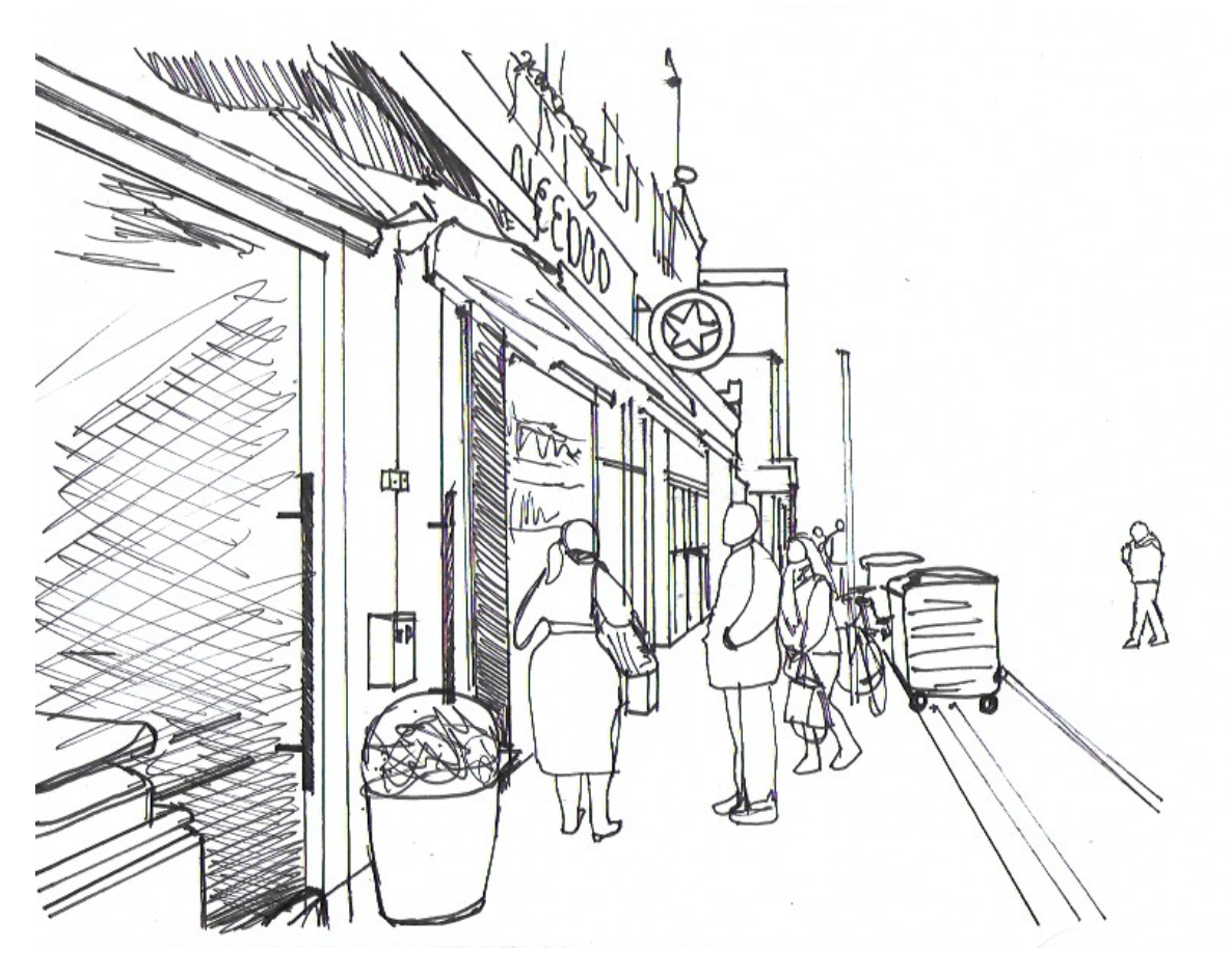
"description": "This is an observational sketch made in 2018 by Sebastian Dawber, a first year architecture student at the University of Westminster.",
"copyright": true,
"created": "2018-05-23"
},
{
"id": 1262,
"title": "75 Whitechapel Road, looking up Greatorex Street in May 2018",
"author": {
"id": 27,
"username": "DerekKendall"
},
"feature": {
"id": 112,
"type": "Feature",
"geometry": {
"type": "MultiPolygon",
"coordinates": [
[
[
[
-0.066957716149887,
51.51736190286489
],
[
-0.067080084424384,
51.51747807555298
],
[
-0.067080079175569,
51.51747808475281
],
[
-0.066975623228904,
51.51751707479948
],
[
-0.066860292367928,
51.51739939698715
],
[
-0.066957716149887,
51.51736190286489
]
]
]
]
},
"properties": {
"b_number": "75",
"b_name": "",
"street": "Whitechapel Road",
"address": "75 Whitechapel Road",
"feature_type": "WHITECHAPEL_BUILDING",
"count": 7,
"search_str": "75 Whitechapel Road"
},
"tags": []
},
"file": "https://surveyoflondon.org/media/uploads/features/112/SoL%20Whitechapel%20102004.jpg",
"description": "",
"copyright": true,
"created": "2018-05-29"
},
{
"id": 1265,
"title": "102-108 Whitechapel Road, May 2018",
"author": {
"id": 27,
"username": "DerekKendall"
},
"feature": {
"id": 862,
"type": "Feature",
"geometry": {
"type": "MultiPolygon",
"coordinates": [
[
[
[
-0.064507263116604,
51.51782788022154
],
[
-0.064384735635999,
51.51786619405259
],
[
-0.064269624814203,
51.517705484506365
],
[
-0.064284781932583,
51.517700755422936
],
[
-0.064240056588541,
51.517636782452485
],
[
-0.064352304125039,
51.51760623597855
],
[
-0.064423378234511,
51.517707896499076
],
[
-0.064507263116604,
51.51782788022154
]
]
]
]
},
"properties": {
"b_number": "104-106",
"b_name": "",
"street": "Whitechapel Road",
"address": "104-106 Whitechapel Road",
"feature_type": "WHITECHAPEL_BUILDING",
"count": 3,
"search_str": "104-106 Whitechapel Road"
},
"tags": []
},
"file": "https://surveyoflondon.org/media/uploads/features/862/SoL%20Whitechapel%20102011.jpg",
"description": "",
"copyright": true,
"created": "2018-05-29"
},
{
"id": 1263,
"title": "97-99 Whitechapel Road, May 2018",
"author": {
"id": 27,
"username": "DerekKendall"
},
"feature": {
"id": 424,
"type": "Feature",
"geometry": {
"type": "MultiPolygon",
"coordinates": [
[
[
[
-0.066699213563065,
51.517546166279914
],
[
-0.066622603379693,
51.51746427446357
],
[
-0.066712853845751,
51.51743773146837
],
[
-0.066759141547469,
51.51743849453354
],
[
-0.06684799078322,
51.517527096013765
],
[
-0.066789648805275,
51.517554444685416
],
[
-0.066755434193492,
51.51752603374355
],
[
-0.066699213563065,
51.517546166279914
]
]
]
]
},
"properties": {
"b_number": "97-99",
"b_name": "",
"street": "Whitechapel Road",
"address": "Islamic Bank of Britain, 97-99 Whitechapel Road",
"feature_type": "WHITECHAPEL_BUILDING",
"count": 7,
"search_str": "Islamic Bank of Britain, 97-99 Whitechapel Road"
},
"tags": []
},
"file": "https://surveyoflondon.org/media/uploads/features/424/SoL%20Whitechapel%20102005.jpg",
"description": "",
"copyright": true,
"created": "2018-05-29"
},
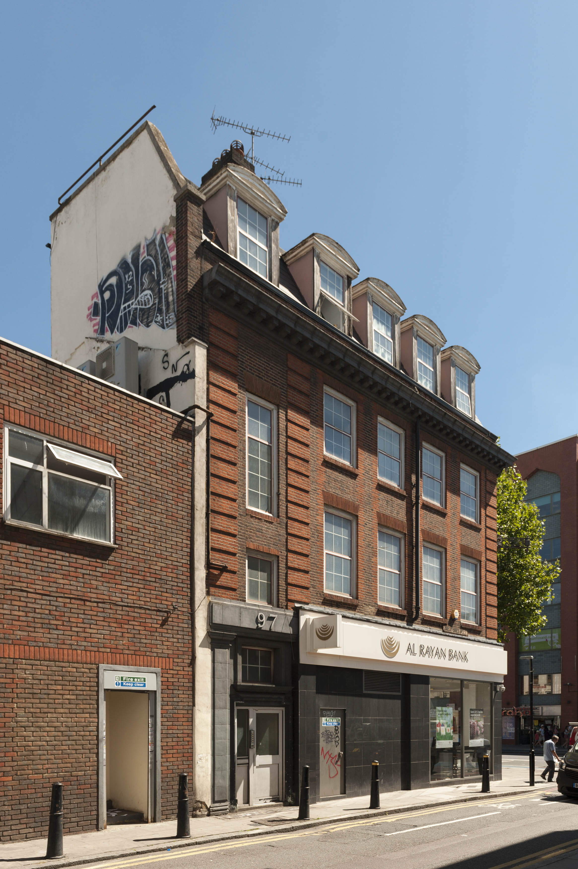
{
"id": 1330,
"title": "97–99 Whitechapel Road, return to Greatorex Street from the northwest, summer 2018",
"author": {
"id": 27,
"username": "DerekKendall"
},
"feature": {
"id": 424,
"type": "Feature",
"geometry": {
"type": "MultiPolygon",
"coordinates": [
[
[
[
-0.066699213563065,
51.517546166279914
],
[
-0.066622603379693,
51.51746427446357
],
[
-0.066712853845751,
51.51743773146837
],
[
-0.066759141547469,
51.51743849453354
],
[
-0.06684799078322,
51.517527096013765
],
[
-0.066789648805275,
51.517554444685416
],
[
-0.066755434193492,
51.51752603374355
],
[
-0.066699213563065,
51.517546166279914
]
]
]
]
},
"properties": {
"b_number": "97-99",
"b_name": "",
"street": "Whitechapel Road",
"address": "Islamic Bank of Britain, 97-99 Whitechapel Road",
"feature_type": "WHITECHAPEL_BUILDING",
"count": 7,
"search_str": "Islamic Bank of Britain, 97-99 Whitechapel Road"
},
"tags": []
},
"file": "https://surveyoflondon.org/media/uploads/features/424/SoL%20Whitechapel%20102100.jpg",
"description": "",
"copyright": true,
"created": "2018-08-13"
},
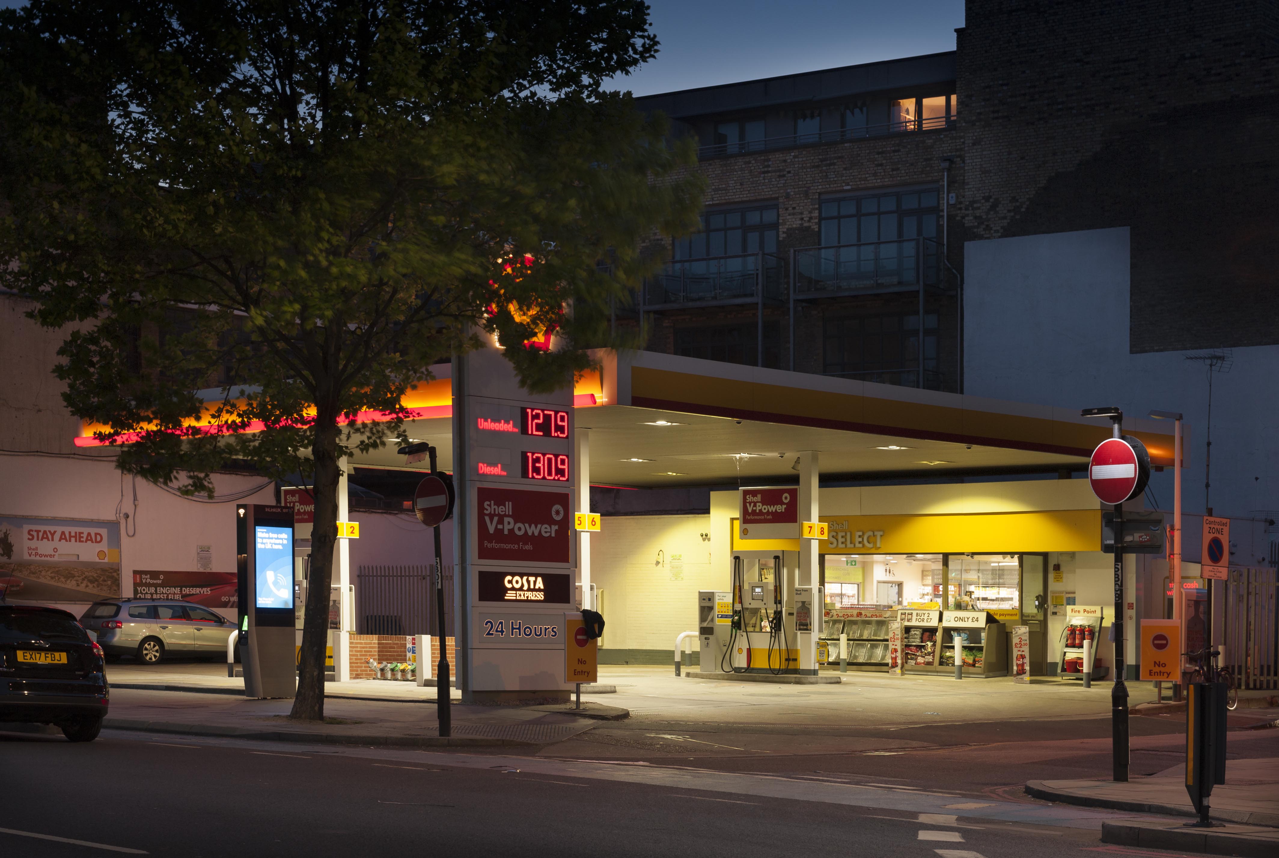
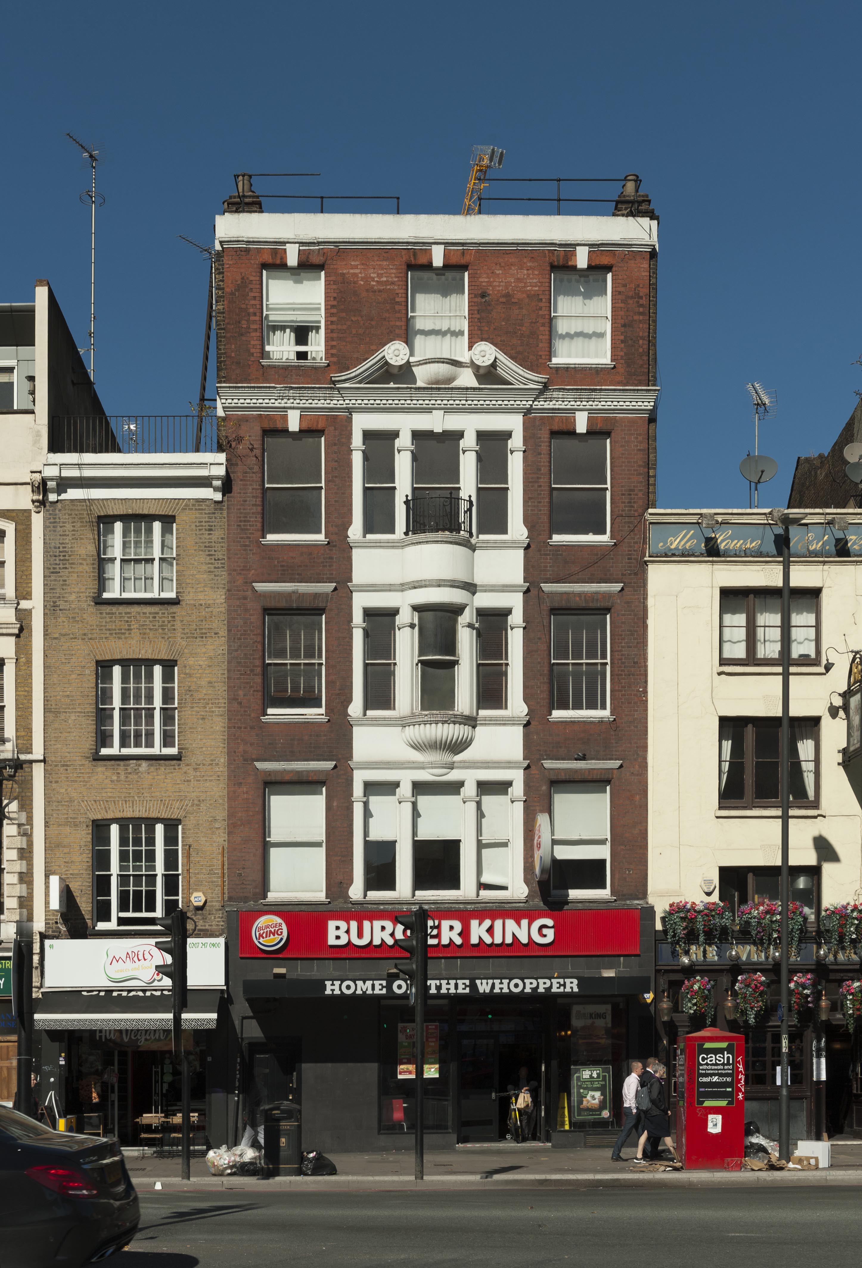
{
"id": 1264,
"title": "Shell petrol station, 139-149 Whitechapel Road in 2018",
"author": {
"id": 27,
"username": "DerekKendall"
},
"feature": {
"id": 438,
"type": "Feature",
"geometry": {
"type": "MultiPolygon",
"coordinates": [
[
[
[
-0.065577466140517,
51.51803559753748
],
[
-0.065394435517867,
51.51809723140592
],
[
-0.065262843396175,
51.51792796097
],
[
-0.065449806129439,
51.517871385932104
],
[
-0.065577466140517,
51.51803559753748
]
]
]
]
},
"properties": {
"b_number": "139-149",
"b_name": "",
"street": "Whitechapel Road",
"address": "Shell Petrol Station, 139-149 Whitechapel Road",
"feature_type": "WHITECHAPEL_BUILDING",
"count": 4,
"search_str": "Shell Petrol Station, 139-149 Whitechapel Road"
},
"tags": [
"synagogue"
]
},
"file": "https://surveyoflondon.org/media/uploads/features/438/SoL%20Whitechapel%20102009.jpg",
"description": "",
"copyright": true,
"created": "2018-05-29"
},
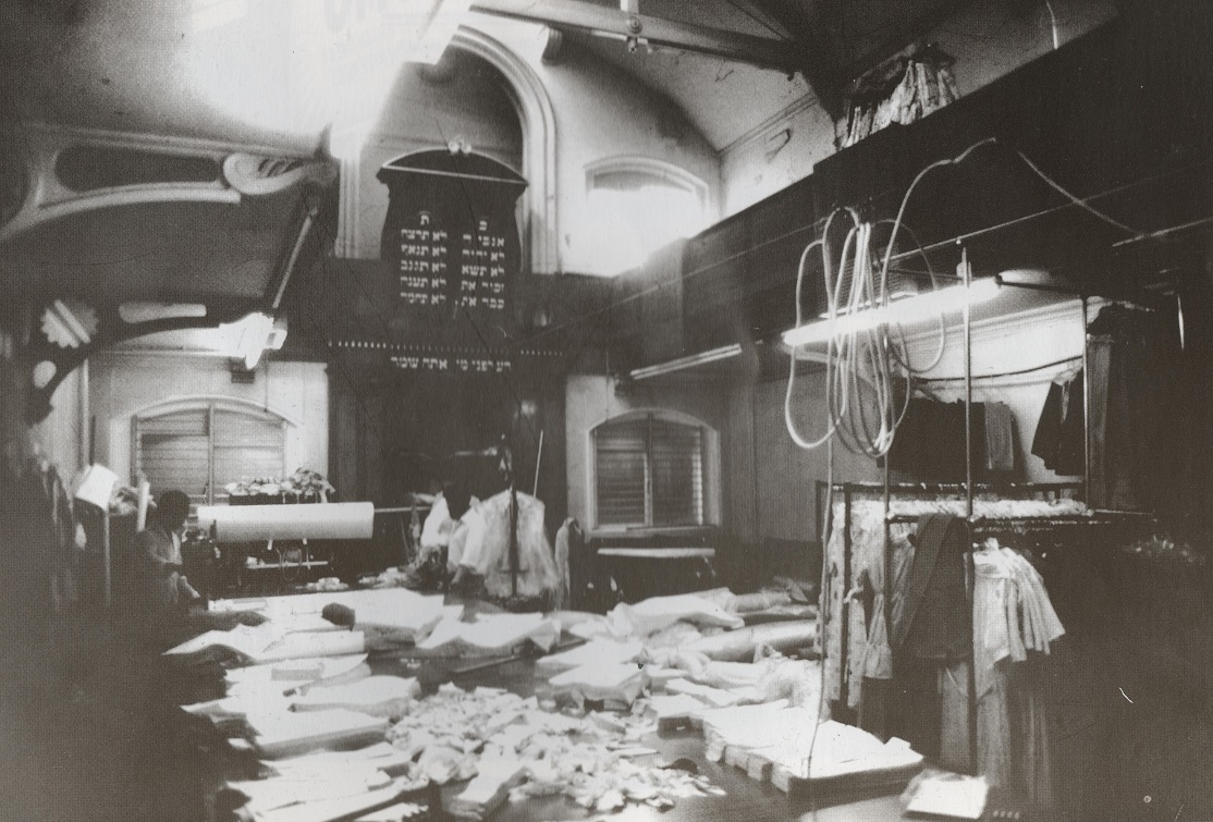
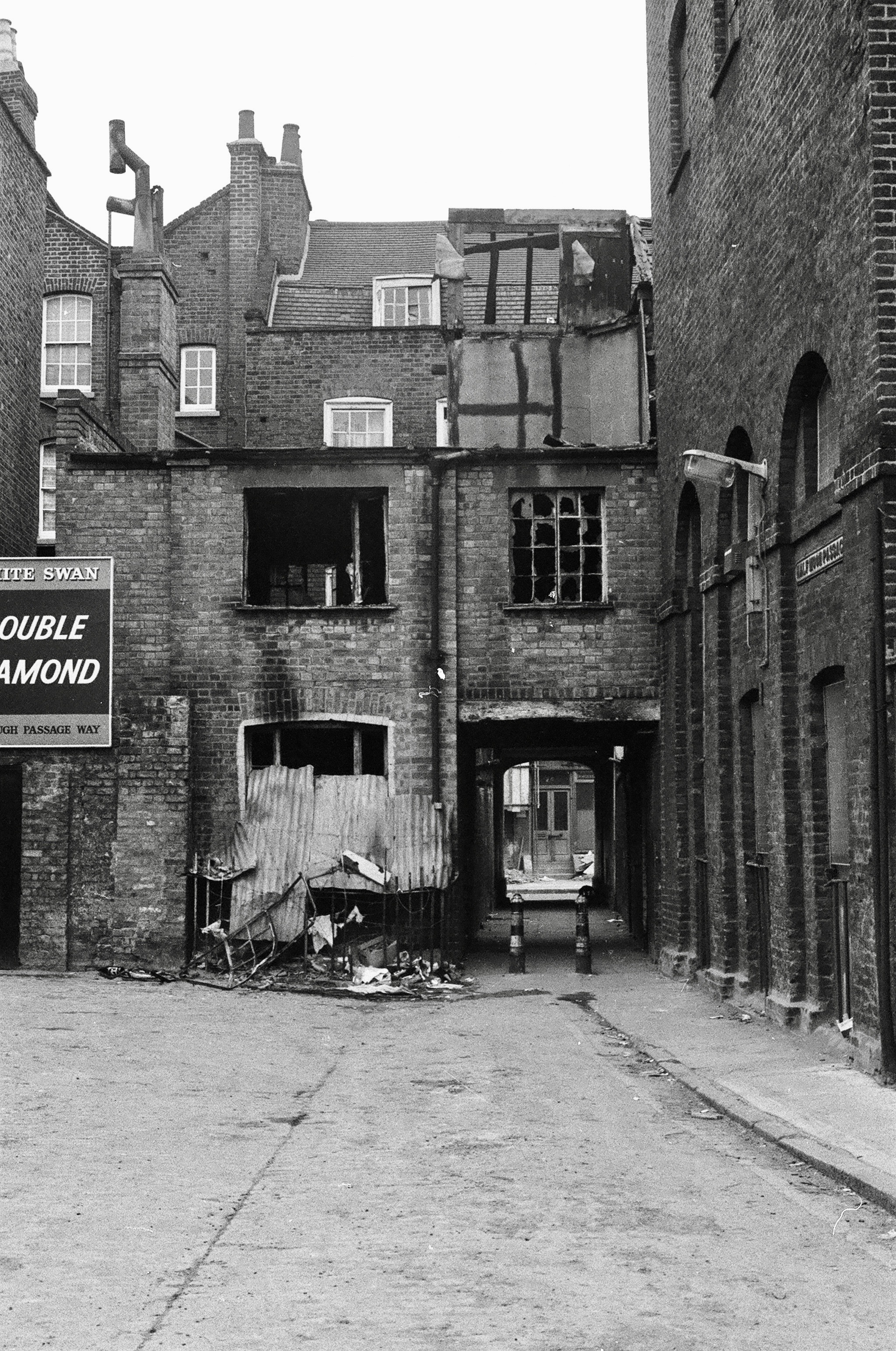
{
"id": 1392,
"title": "New Road synagogue in use as a workshop, 1980",
"author": {
"id": 2,
"username": "surveyoflondon"
},
"feature": {
"id": 1463,
"type": "Feature",
"geometry": {
"type": "MultiPolygon",
"coordinates": [
[
[
[
-0.063134492360364,
51.51782738505861
],
[
-0.063025709537606,
51.51764418006528
],
[
-0.062931156135412,
51.51766686232899
],
[
-0.062954889604093,
51.51770900962472
],
[
-0.062726482458675,
51.517765079903484
],
[
-0.062748999276863,
51.51780173726752
],
[
-0.062973174374441,
51.51774578529897
],
[
-0.063032903202825,
51.51784972503275
],
[
-0.063134492360364,
51.51782738505861
]
]
]
]
},
"properties": {
"b_number": "115",
"b_name": "",
"street": "New Road",
"address": "115 New Road and the former New Road Synagogue",
"feature_type": "WHITECHAPEL_BUILDING",
"count": 9,
"search_str": "115 New Road and the former New Road Synagogue"
},
"tags": [
"Lewis Solomon",
"Samuel Montagu"
]
},
"file": "https://surveyoflondon.org/media/uploads/features/1463/Newroadmed.jpg",
"description": "After New Road Synagogue closed in 1973, it became a Bengali dress factory, seen here in 1980. It has subsequently been subdivided and converted to office use. ",
"copyright": false,
"created": "2018-10-31"
},
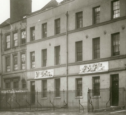
{
"id": 1214,
"title": "20-21 Wellclose Square, Danish Consulate",
"author": {
"id": 33,
"username": "Charno"
},
"feature": {
"id": 1395,
"type": "Feature",
"geometry": {
"type": "MultiPolygon",
"coordinates": [
[
[
[
-0.06734277723579,
51.5101408267643
],
[
-0.066910949136799,
51.510217428527255
],
[
-0.066795977317392,
51.50998414164829
],
[
-0.066852430868868,
51.50997111905564
],
[
-0.066833669508271,
51.50993011276243
],
[
-0.066709688224837,
51.50995364978504
],
[
-0.066597753455944,
51.50973669156566
],
[
-0.067039183086463,
51.50965327261519
],
[
-0.067087140764219,
51.50975289871178
],
[
-0.067115318173266,
51.50974754930748
],
[
-0.067147894414189,
51.50981436423853
],
[
-0.067117953240777,
51.50981735903555
],
[
-0.067140193085813,
51.50986423647582
],
[
-0.067209730295633,
51.509850266595954
],
[
-0.06734277723579,
51.5101408267643
]
]
]
]
},
"properties": {
"b_number": "",
"b_name": "Shapla Primary School",
"street": "Wellclose Square",
"address": "Shapla Primary School",
"feature_type": "WHITECHAPEL_BUILDING",
"count": 11,
"search_str": "Shapla Primary School"
},
"tags": []
},
"file": "https://surveyoflondon.org/media/uploads/features/1395/Danish%20Embassy%20Wellclose%20Sq.jpg",
"description": "The Danish consulate (r) was established by Georg Wolff at his business address, 20-21 Wellclose Square. A timber merchant, Wolff became consul in 1787. In 1796 the frontage was decorated with two Coade stone plaques, which can be seen in the image. Nowadays they can be seen at the Norwegian Embassy, Belgrave Place. The building was demolished in 1968.",
"copyright": false,
"created": "2018-03-09"
},
{
"id": 1358,
"title": "90 Whitechapel High Street in 2018",
"author": {
"id": 27,
"username": "DerekKendall"
},
"feature": {
"id": 322,
"type": "Feature",
"geometry": {
"type": "MultiPolygon",
"coordinates": [
[
[
[
-0.070826085356955,
51.515731678715305
],
[
-0.070926036876346,
51.51568963184868
],
[
-0.070975568878107,
51.51573563457872
],
[
-0.070938498759621,
51.51574884259805
],
[
-0.071053600330032,
51.515872108514294
],
[
-0.070987330377168,
51.51589641332655
],
[
-0.070910007660269,
51.515813725352466
],
[
-0.070826085356955,
51.515731678715305
]
]
]
]
},
"properties": {
"b_number": "90",
"b_name": "90 Whitechapel High Street",
"street": "Whitechapel High Street",
"address": "90 Whitechapel High Street",
"feature_type": "WHITECHAPEL_BUILDING",
"count": 5,
"search_str": "90 Whitechapel High Street"
},
"tags": []
},
"file": "https://surveyoflondon.org/media/uploads/features/322/SoL%20Whitechapel%20102214.jpg",
"description": "",
"copyright": true,
"created": "2018-10-10"
},
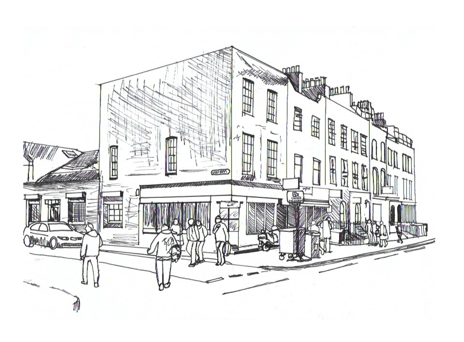
{
"id": 1257,
"title": "Corner of New Road and Varden Street",
"author": {
"id": 232,
"username": "Sebastian_Dawber"
},
"feature": {
"id": 1133,
"type": "Feature",
"geometry": {
"type": "MultiPolygon",
"coordinates": [
[
[
[
-0.06180843280572,
51.51547588062743
],
[
-0.061956406812953,
51.51546378828541
],
[
-0.061967609606242,
51.51551715426207
],
[
-0.06169504700941,
51.51553848416248
],
[
-0.061679365436623,
51.51547050225325
],
[
-0.061746993512272,
51.51546460379417
],
[
-0.061753931149311,
51.5154959694269
],
[
-0.061811531093857,
51.51549154661211
],
[
-0.06180843280572,
51.51547588062743
]
]
]
]
},
"properties": {
"b_number": "20",
"b_name": "",
"street": "New Road",
"address": "20 New Road",
"feature_type": "WHITECHAPEL_BUILDING",
"count": 3,
"search_str": "20 New Road"
},
"tags": []
},
"file": "https://surveyoflondon.org/media/uploads/features/1133/Screen%20Shot%202018-05-23%20at%2018.03.01.png",
"description": "This is an observational sketch made in 2018 by Sebastian Dawber, a first year architecture student at the University of Westminster.",
"copyright": true,
"created": "2018-05-23"
},
{
"id": 1448,
"title": "Half Moon Passage, looking south towards Alie Street in the early 1970s (photograph by Dan Cruickshank)",
"author": {
"id": 268,
"username": "DanCruickshank"
},
"feature": {
"id": 33,
"type": "Feature",
"geometry": {
"type": "MultiPolygon",
"coordinates": [
[
[
[
-0.071865525294463,
51.513635775949055
],
[
-0.071785458230957,
51.51353968533075
],
[
-0.071900260305993,
51.51350038640229
],
[
-0.07197326495485,
51.51359817527253
],
[
-0.071865525294463,
51.513635775949055
]
]
]
]
},
"properties": {
"b_number": "17-19",
"b_name": "",
"street": "Alie Street",
"address": "17-19 Alie Street",
"feature_type": "WHITECHAPEL_BUILDING",
"count": 5,
"search_str": "17-19 Alie Street"
},
"tags": []
},
"file": "https://surveyoflondon.org/media/uploads/features/33/00170006.jpg",
"description": "",
"copyright": true,
"created": "2018-11-16"
},
{
"id": 27,
"title": "27 Commercial Road",
"author": {
"id": 27,
"username": "DerekKendall"
},
"feature": {
"id": 102,
"type": "Feature",
"geometry": {
"type": "MultiPolygon",
"coordinates": [
[
[
[
-0.068884991325227,
51.51509176890641
],
[
-0.068884964761477,
51.515091771690116
],
[
-0.068794658458709,
51.51512331365302
],
[
-0.068755208747082,
51.51507437068053
],
[
-0.068763951154488,
51.515060519662065
],
[
-0.06878690364361,
51.51504817492868
],
[
-0.068894901526045,
51.51504995339762
],
[
-0.068909858606256,
51.515082006494964
],
[
-0.068884991325227,
51.51509176890641
]
]
]
]
},
"properties": {
"b_number": "27",
"b_name": "",
"street": "Commercial Road",
"address": "27 Commercial Road",
"feature_type": "WHITECHAPEL_BUILDING",
"count": 10,
"search_str": "27 Commercial Road"
},
"tags": []
},
"file": "https://surveyoflondon.org/media/uploads/features/102/SoL%20Whitechapel100201.jpg",
"description": "",
"copyright": true,
"created": "2016-06-20"
},
{
"id": 1287,
"title": "Leman Street elevation looking south west, March 2018",
"author": {
"id": 27,
"username": "DerekKendall"
},
"feature": {
"id": 89,
"type": "Feature",
"geometry": {
"type": "MultiPolygon",
"coordinates": [
[
[
[
-0.070412526360238,
51.513121210909055
],
[
-0.07028332473823,
51.51315838751862
],
[
-0.070261188208979,
51.51312785594812
],
[
-0.070391089194003,
51.51309189976837
],
[
-0.070412526360238,
51.513121210909055
]
]
]
]
},
"properties": {
"b_number": "64",
"b_name": "",
"street": "Leman Street",
"address": "64 Leman Street",
"feature_type": "WHITECHAPEL_BUILDING",
"count": 3,
"search_str": "64 Leman Street"
},
"tags": []
},
"file": "https://surveyoflondon.org/media/uploads/features/89/SoL%20Whitechapel%20101959.jpg",
"description": "",
"copyright": true,
"created": "2018-08-07"
},
{
"id": 1288,
"title": "Elevation, March 2018",
"author": {
"id": 27,
"username": "DerekKendall"
},
"feature": {
"id": 89,
"type": "Feature",
"geometry": {
"type": "MultiPolygon",
"coordinates": [
[
[
[
-0.070412526360238,
51.513121210909055
],
[
-0.07028332473823,
51.51315838751862
],
[
-0.070261188208979,
51.51312785594812
],
[
-0.070391089194003,
51.51309189976837
],
[
-0.070412526360238,
51.513121210909055
]
]
]
]
},
"properties": {
"b_number": "64",
"b_name": "",
"street": "Leman Street",
"address": "64 Leman Street",
"feature_type": "WHITECHAPEL_BUILDING",
"count": 3,
"search_str": "64 Leman Street"
},
"tags": []
},
"file": "https://surveyoflondon.org/media/uploads/features/89/SoL%20Whitechapel%20101964.jpg",
"description": "",
"copyright": true,
"created": "2018-08-07"
},
{
"id": 1239,
"title": "View to south-west, February 2018",
"author": {
"id": 27,
"username": "DerekKendall"
},
"feature": {
"id": 39,
"type": "Feature",
"geometry": {
"type": "MultiPolygon",
"coordinates": [
[
[
[
-0.071664079468146,
51.51343051902844
],
[
-0.071600413466814,
51.513454875943125
],
[
-0.071534942236408,
51.51337367949251
],
[
-0.071598443192382,
51.51335322818265
],
[
-0.071664079468146,
51.51343051902844
]
]
]
]
},
"properties": {
"b_number": "2–6",
"b_name": "",
"street": "St Mark Street",
"address": "2–6 St Mark Street",
"feature_type": "WHITECHAPEL_BUILDING",
"count": 6,
"search_str": "2–6 St Mark Street"
},
"tags": []
},
"file": "https://surveyoflondon.org/media/uploads/features/39/SoL%20Whitechapel%20101827.jpg",
"description": "",
"copyright": true,
"created": "2018-04-13"
},
{
"id": 1638,
"title": "Wombat's (former Sailors' Home), cross section in 1865 and phased ground plan as in 2014",
"author": {
"id": 82,
"username": "HelenJones"
},
"feature": {
"id": 1385,
"type": "Feature",
"geometry": {
"type": "MultiPolygon",
"coordinates": [
[
[
[
-0.067575803709333,
51.51021492278667
],
[
-0.067783647338447,
51.51017527172947
],
[
-0.067828706900756,
51.510167293395675
],
[
-0.067884358000762,
51.51028332470727
],
[
-0.068021222270461,
51.51026117174896
],
[
-0.068027105232624,
51.51027869995762
],
[
-0.068059007104689,
51.51027341168682
],
[
-0.068045803249401,
51.51025517119752
],
[
-0.068185711037114,
51.51022956959143
],
[
-0.068302205657116,
51.51049311218949
],
[
-0.068154065018083,
51.51051508999573
],
[
-0.068142111677326,
51.51048931210634
],
[
-0.068158013519995,
51.51048782991857
],
[
-0.0680993992664,
51.51035372697415
],
[
-0.068063773094401,
51.51035895389879
],
[
-0.068055396596396,
51.510336723241444
],
[
-0.067963562571312,
51.510349163498944
],
[
-0.067961653646245,
51.510339150568754
],
[
-0.067909585576321,
51.510347692789416
],
[
-0.067933270683552,
51.5104044774377
],
[
-0.067674158297256,
51.51045078856997
],
[
-0.067629160671485,
51.51036923447038
],
[
-0.067652633918951,
51.51036497018876
],
[
-0.067575803709333,
51.51021492278667
]
]
]
]
},
"properties": {
"b_number": "7",
"b_name": "",
"street": "Dock Street",
"address": "Wombat's City Hostel, 7 Dock Street",
"feature_type": "WHITECHAPEL_BUILDING",
"count": 25,
"search_str": "Wombat's City Hostel, 7 Dock Street"
},
"tags": []
},
"file": "https://surveyoflondon.org/media/uploads/features/1385/Sailors%20home%20section%20and%20phase%20plan%20combined_SaJZsV5.jpg",
"description": "",
"copyright": true,
"created": "2019-08-06"
},
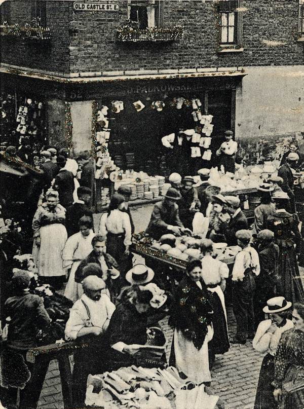
{
"id": 1378,
"title": "Mark Palkwoski's chinaware shop, Wentworth St and Old Castle Street",
"author": {
"id": 252,
"username": "mark3"
},
"feature": {
"id": 1742,
"type": "Feature",
"geometry": {
"type": "MultiPolygon",
"coordinates": [
[
[
[
-0.076387722492951,
51.516257872286374
],
[
-0.07580974439088,
51.51649846859169
],
[
-0.075744693982384,
51.51651411423466
],
[
-0.075332716624042,
51.51665341173461
],
[
-0.075277819023276,
51.516667372076085
],
[
-0.074429584483841,
51.51681699796736
],
[
-0.074402209988697,
51.516763242480046
],
[
-0.075229889371391,
51.51661092868018
],
[
-0.074836715281391,
51.516135055700595
],
[
-0.074917049606191,
51.51611135328064
],
[
-0.075312012611936,
51.51658616747119
],
[
-0.075695505281233,
51.51646463519818
],
[
-0.075779072585588,
51.51644696856364
],
[
-0.076328753388395,
51.516209038390684
],
[
-0.076387722492951,
51.516257872286374
]
]
]
]
},
"properties": {
"b_number": "",
"b_name": "",
"street": "",
"address": "Petticoat Lane Market",
"feature_type": "PLACE",
"count": 39,
"search_str": "Petticoat Lane Market"
},
"tags": []
},
"file": "https://surveyoflondon.org/media/uploads/features/1742/Palkowski%20china%20h.jpg",
"description": "Prior to moving across the road to 59 Wentworth Street (Marks of the Lane Deli), my great grandfather Mark Palkowski and family owned this store with their warehouse sited a few buildings down in Old Castle Street ",
"copyright": false,
"created": "2018-10-28"
},
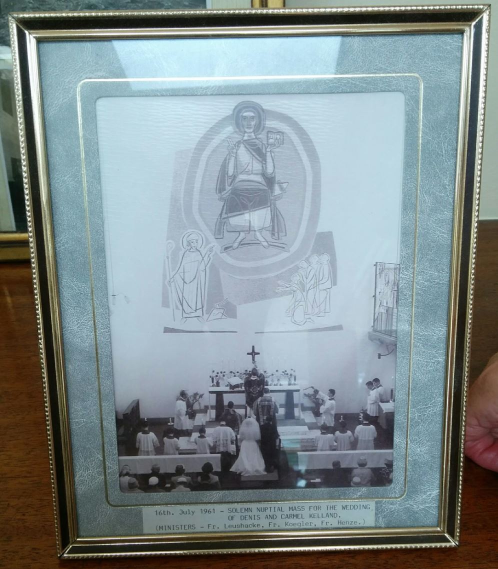
{
"id": 669,
"title": "Marriage of Denis and Carmel Kelland in St Boniface, 16 July 1961",
"author": {
"id": 22,
"username": "sarahannmilne"
},
"feature": {
"id": 308,
"type": "Feature",
"geometry": {
"type": "MultiPolygon",
"coordinates": [
[
[
[
-0.067496567815311,
51.51589253877067
],
[
-0.067329816922355,
51.51592882147948
],
[
-0.067313994004403,
51.515903740519775
],
[
-0.067285655221522,
51.51591108028059
],
[
-0.067273890464753,
51.51588586669939
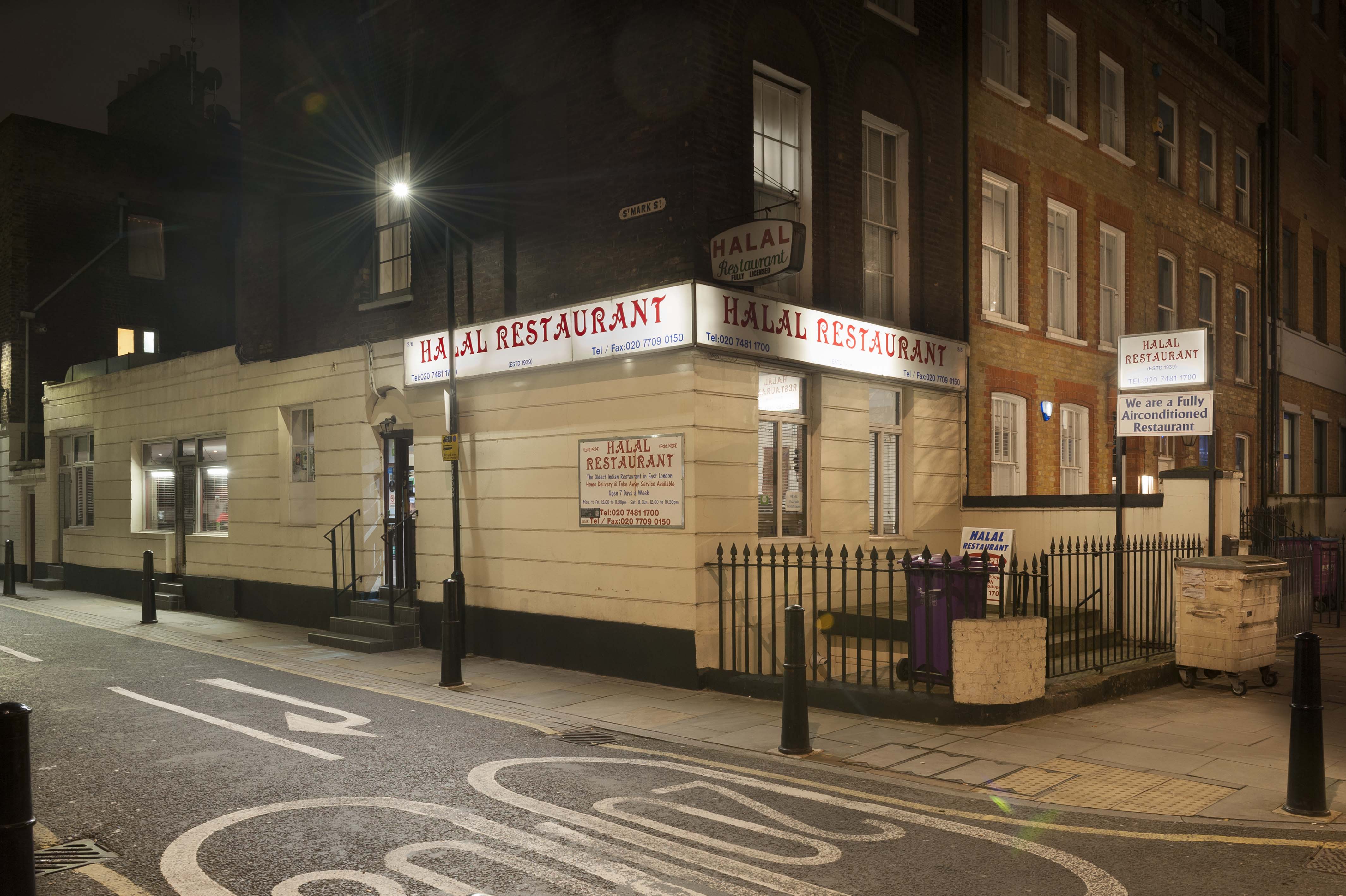
],
[
-0.067248552659892,
51.51589046902255
],
[
-0.067167351332256,
51.515743576397455
],
[
-0.067193642426533,
51.51573542676791
],
[
-0.06717129258716,
51.51569502690211
],
[
-0.067371819133296,
51.51564515293278
],
[
-0.067482004602165,
51.515831045103695
],
[
-0.067463735896854,
51.51583606330445
],
[
-0.067496567815311,
51.51589253877067
]
]
]
]
},
"properties": {
"b_number": "47",
"b_name": "",
"street": "Adler Street",
"address": "St Boniface German Church, 47 Adler Street",
"feature_type": "WHITECHAPEL_BUILDING",
"count": 14,
"search_str": "St Boniface German Church, 47 Adler Street"
},
"tags": [
"Catholic Church",
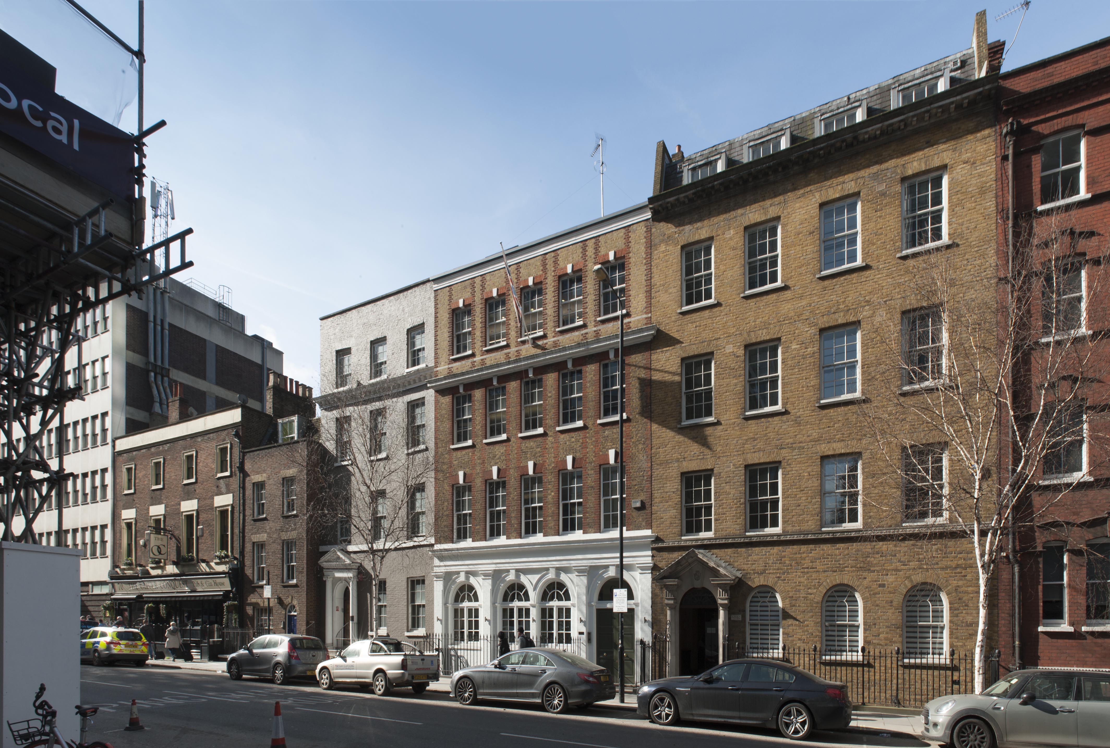
"Germans"
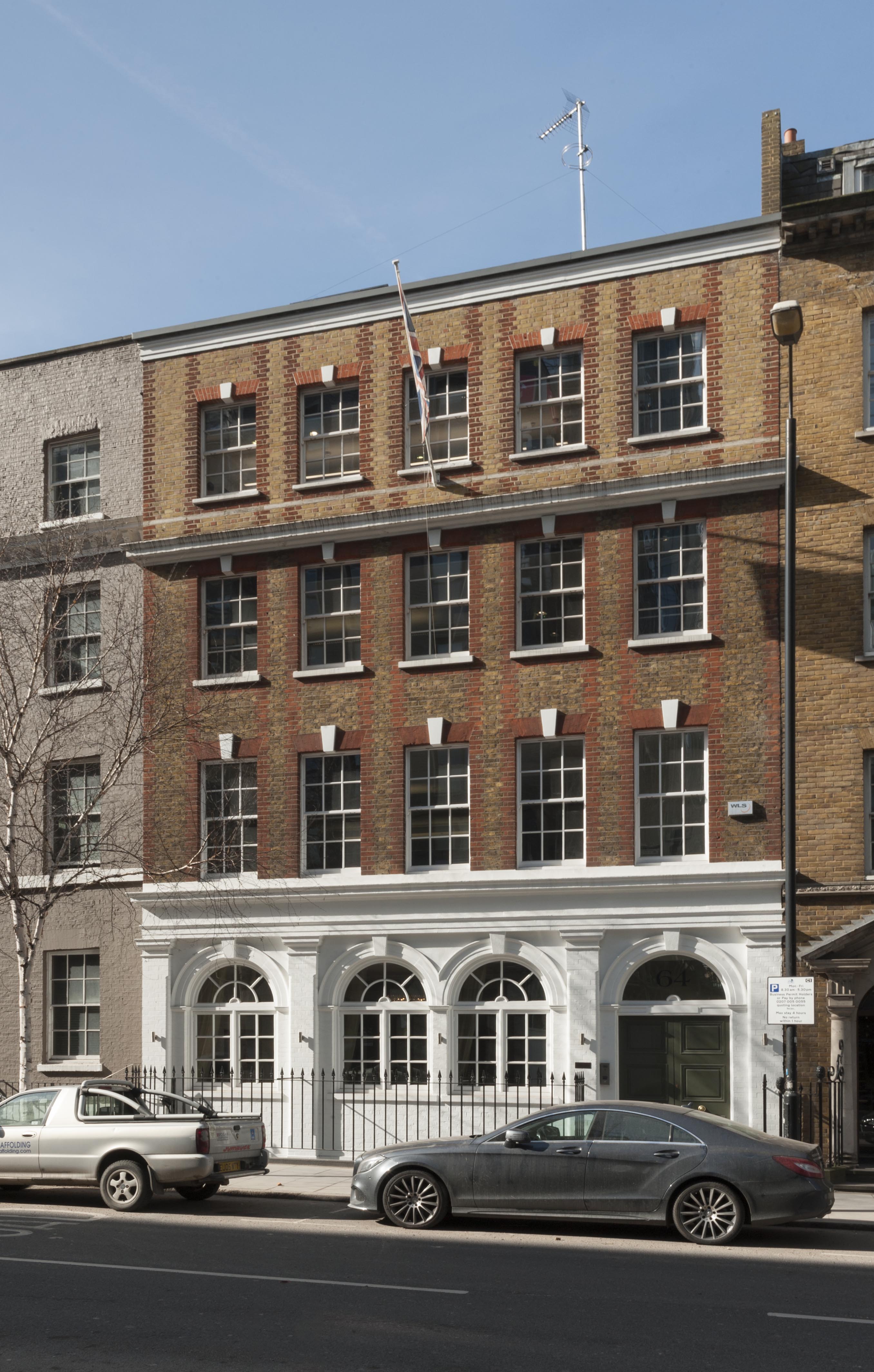
]
},
"file": "https://surveyoflondon.org/media/uploads/features/308/2.JPG",
"description": "Denis, of German descent, married Carmel, of Irish descent, in one of the first weddings to take place in the newly rebuilt church. Denis acted as Master of Ceremonies in the church for many years. Here the interior of the church is shown before the alterations made after Vatican II when the altar rail and pulpit were removed. ",
"copyright": false,
"created": "2017-05-15"
},
{
"id": 1238,
"title": "East elevation, February 2018",
"author": {
"id": 27,
"username": "DerekKendall"
},
"feature": {
"id": 39,
"type": "Feature",
"geometry": {
"type": "MultiPolygon",
"coordinates": [
[
[
[
-0.071664079468146,
51.51343051902844
],
[
-0.071600413466814,
51.513454875943125
],
[
-0.071534942236408,
51.51337367949251
],
[
-0.071598443192382,
51.51335322818265
],
[
-0.071664079468146,
51.51343051902844
]
]
]
]
},
"properties": {
"b_number": "2–6",
"b_name": "",
"street": "St Mark Street",
"address": "2–6 St Mark Street",
"feature_type": "WHITECHAPEL_BUILDING",
"count": 6,
"search_str": "2–6 St Mark Street"
},
"tags": []
},
"file": "https://surveyoflondon.org/media/uploads/features/39/SoL%20Whitechapel%20101829.jpg",
"description": "",
"copyright": true,
"created": "2018-04-13"
},
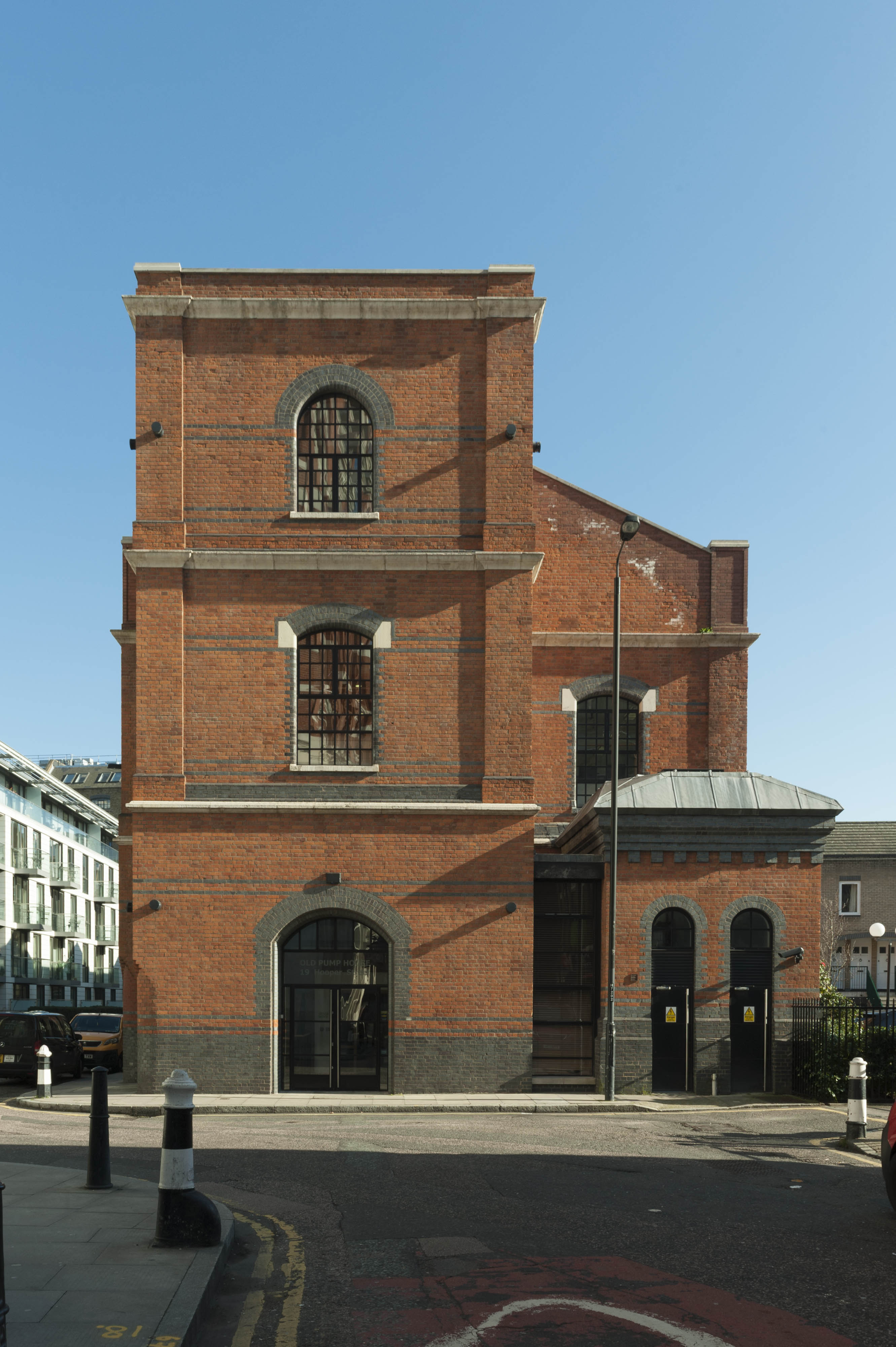
{
"id": 1543,
"title": "Pump House, view from the west in 2019",
"author": {
"id": 27,
"username": "DerekKendall"
},
"feature": {
"id": 1010,
"type": "Feature",
"geometry": {
"type": "MultiPolygon",
"coordinates": [
[
[
[
-0.068555698048877,
51.51204452198014
],
[
-0.068555326202895,
51.51204485879359
],
[
-0.068554770831345,
51.512045081502
],
[
-0.068497504981719,
51.512052919430616
],
[
-0.068502175463734,
51.51206547578974
],
[
-0.068502752988489,
51.51206703010359
],
[
-0.06850288398942,
51.51206798740001
],
[
-0.068502971173769,
51.51206916405696
],
[
-0.068502347255853,
51.51206991451387
],
[
-0.068499993050397,
51.5120710221773
],
[
-0.068242392564589,
51.51210964685258
],
[
-0.0682410644557,
51.51210973399245
],
[
-0.068239642322559,
51.51210952007609
],
[
-0.068238714527799,
51.51210890352617
],
[
-0.068238207947228,
51.512107700217044
],
[
-0.068188144824087,
51.51197782828397
],
[
-0.068453135501772,
51.51193815405404
],
[
-0.068515159282885,
51.51192814155626
],
[
-0.068530310562288,
51.51197703749692
],
[
-0.06855299134469,
51.51203601813206
],
[
-0.068553831126054,
51.51203820195318
],
[
-0.068555912716636,
51.51204390119794
],
[
-0.068555889466022,
51.51204424727518
],
[
-0.068555698048877,
51.51204452198014
]
]
]
]
},
"properties": {
"b_number": "19",
"b_name": "Old Pump House, 19-20 Hooper Street",
"street": "Hooper Street",
"address": "Old Pump House, 19–20 Hooper Street",
"feature_type": "WHITECHAPEL_BUILDING",
"count": 6,
"search_str": "Old Pump House, 19-20 Hooper Street"
},
"tags": []
},
"file": "https://surveyoflondon.org/media/uploads/features/1010/SoL%20Whitechapel%20102658.jpg",
"description": "",
"copyright": true,
"created": "2019-03-05"
}
]
}