HTTP 200 OK
Allow: GET, HEAD, OPTIONS
Content-Type: application/json
Vary: Accept
{
"count": 1747,
"next": "https://surveyoflondon.org/api/v1/images/?format=api&page=59",
"previous": "https://surveyoflondon.org/api/v1/images/?format=api&page=57",
"results": [
{
"id": 957,
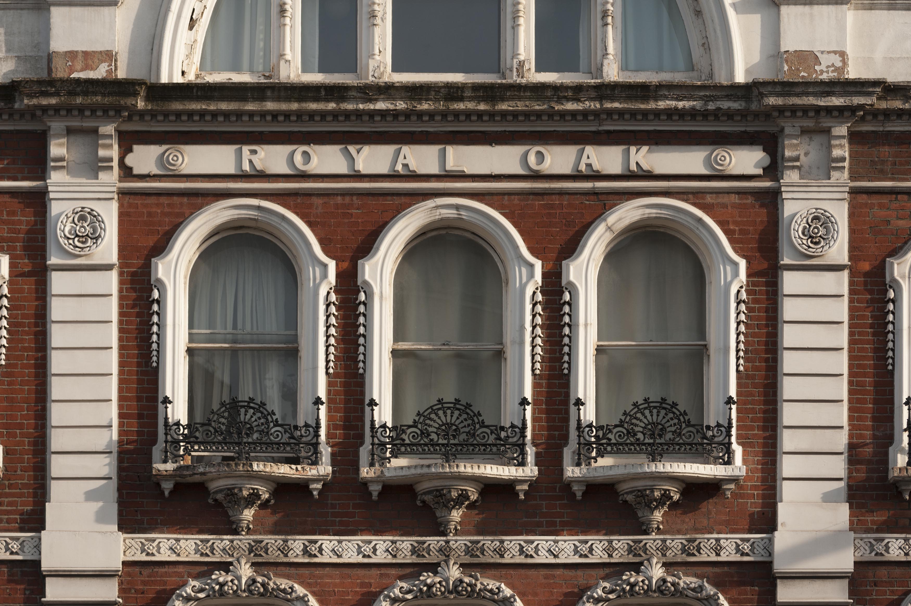
"title": "Former Royal Oak public house, facade detail, March 2017",
"author": {
"id": 27,
"username": "DerekKendall"
},
"feature": {
"id": 873,
"type": "Feature",
"geometry": {
"type": "MultiPolygon",
"coordinates": [
[
[
[
-0.063739503777729,
51.51804861845898
],
[
-0.063683451117025,
51.51797300209851
],
[
-0.0637089382797,
51.51796483346984
],
[
-0.063836182144524,
51.51792452272944
],
[
-0.063835842009052,
51.51792462190747
],
[
-0.063877274830691,
51.51791330545044
],
[
-0.063934479931202,
51.51800468952643
],
[
-0.063739503777729,
51.51804861845898
]
]
]
]
},
"properties": {
"b_number": "118-120",
"b_name": "Former Royal Oak public house",
"street": "Whitechapel Road",
"address": "Former Royal Oak public house, 118-120 Whitechapel Road",
"feature_type": "WHITECHAPEL_BUILDING",
"count": 9,
"search_str": "Former Royal Oak public house"
},
"tags": [
"Royal Oak"
]
},
"file": "https://surveyoflondon.org/media/uploads/features/873/SoL%20Whitechapel%20100755.jpg",
"description": "",
"copyright": true,
"created": "2017-11-30"
},
{
"id": 1283,
"title": "Elevation to Leman Street, looking south west",
"author": {
"id": 27,
"username": "DerekKendall"
},
"feature": {
"id": 1304,
"type": "Feature",
"geometry": {
"type": "MultiPolygon",
"coordinates": [
[
[
[
-0.069869457142711,
51.51258378865529
],
[
-0.06950660421144,
51.512121667706516
],
[
-0.069478111577185,
51.512130555532515
],
[
-0.069341094752535,
51.511957536645845
],
[
-0.069486122416778,
51.51189676528385
],
[
-0.069527178527717,
51.51194539520137
],
[
-0.069585888426032,
51.5119311567419
],
[
-0.069559567943928,
51.511910840078386
],
[
-0.069569328998767,
51.5119016438785
],
[
-0.069825289223036,
51.51185497911268
],
[
-0.069930830059169,
51.51200246852669
],
[
-0.069714923949871,
51.51207129486504
],
[
-0.069748586678379,
51.512117463780626
],
[
-0.069782896356969,
51.51210399319554
],
[
-0.070024013079544,
51.51238632902739
],
[
-0.070141581896045,
51.51235434519941
],
[
-0.070216203746602,
51.51245148127667
],
[
-0.070170852543001,
51.512460091841156
],
[
-0.070181004677215,
51.512485990340465
],
[
-0.07007117524811,
51.51251225352792
],
[
-0.070078075053951,
51.512526402406536
],
[
-0.069869457142711,
51.51258378865529
]
]
]
]
},
"properties": {
"b_number": "100",
"b_name": "",
"street": "Leman Street",
"address": "100 Leman Street (Minet House)",
"feature_type": "WHITECHAPEL_BUILDING",
"count": 13,
"search_str": "100 Leman Street (Minet House)"
},
"tags": []
},
"file": "https://surveyoflondon.org/media/uploads/features/1304/SoL%20Whitechapel%20101979.jpg",
"description": "",
"copyright": true,
"created": "2018-08-07"
},
{
"id": 717,
"title": "Dock Street hostel from the north-west in 2017",
"author": {
"id": 27,
"username": "DerekKendall"
},
"feature": {
"id": 1385,
"type": "Feature",
"geometry": {
"type": "MultiPolygon",
"coordinates": [
[
[
[
-0.067575803709333,
51.51021492278667
],
[
-0.067783647338447,
51.51017527172947
],
[
-0.067828706900756,
51.510167293395675
],
[
-0.067884358000762,
51.51028332470727
],
[
-0.068021222270461,
51.51026117174896
],
[
-0.068027105232624,
51.51027869995762
],
[
-0.068059007104689,
51.51027341168682
],
[
-0.068045803249401,
51.51025517119752
],
[
-0.068185711037114,
51.51022956959143
],
[
-0.068302205657116,
51.51049311218949
],
[
-0.068154065018083,
51.51051508999573
],
[
-0.068142111677326,
51.51048931210634
],
[
-0.068158013519995,
51.51048782991857
],
[
-0.0680993992664,
51.51035372697415
],
[
-0.068063773094401,
51.51035895389879
],
[
-0.068055396596396,
51.510336723241444
],
[
-0.067963562571312,
51.510349163498944
],
[
-0.067961653646245,
51.510339150568754
],
[
-0.067909585576321,
51.510347692789416
],
[
-0.067933270683552,
51.5104044774377
],
[
-0.067674158297256,
51.51045078856997
],
[
-0.067629160671485,
51.51036923447038
],
[
-0.067652633918951,
51.51036497018876
],
[
-0.067575803709333,
51.51021492278667
]
]
]
]
},
"properties": {
"b_number": "7",
"b_name": "",
"street": "Dock Street",
"address": "Wombat's City Hostel, 7 Dock Street",
"feature_type": "WHITECHAPEL_BUILDING",
"count": 25,
"search_str": "Wombat's City Hostel, 7 Dock Street"
},
"tags": []
},
"file": "https://surveyoflondon.org/media/uploads/features/1385/SoL%20Whitechapel%20101144.jpg",
"description": "",
"copyright": true,
"created": "2017-08-02"
},
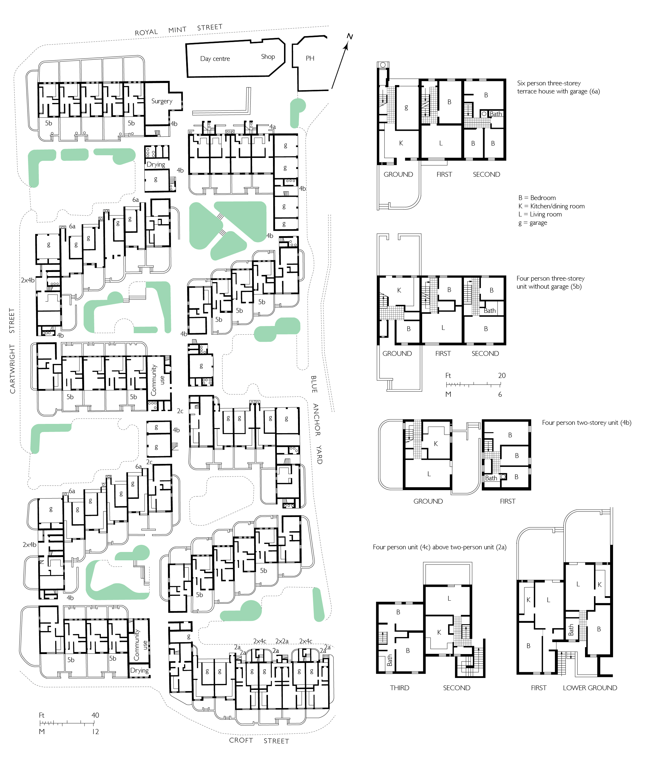
{
"id": 1641,
"title": "The Royal Mint Estate as designed in 1974",
"author": {
"id": 82,
"username": "HelenJones"
},
"feature": {
"id": 1700,
"type": "Feature",
"geometry": {
"type": "MultiPolygon",
"coordinates": [
[
[
[
-0.070945132337544,
51.51021419997014
],
[
-0.070951067578723,
51.5102277140376
],
[
-0.070898811199882,
51.51023714629324
],
[
-0.070917381971465,
51.51027716141803
],
[
-0.070881130885056,
51.51028295731296
],
[
-0.070862738106381,
51.510248608310874
],
[
-0.070769476297735,
51.51026743533961
],
[
-0.070788252129627,
51.510301925514284
],
[
-0.070753203361862,
51.51030775757811
],
[
-0.070735310409513,
51.51027458406735
],
[
-0.07068160237232,
51.51028211859123
],
[
-0.070640721365031,
51.51018467843966
],
[
-0.070890187021744,
51.510140890147795
],
[
-0.070889379574192,
51.510138140235156
],
[
-0.070901160084848,
51.510135712013096
],
[
-0.070945132337544,
51.51021419997014
]
]
]
]
},
"properties": {
"b_number": "23-29",
"b_name": "",
"street": "Royal Mint Street",
"address": "23-29 Royal Mint Street, Royal Mint Estate",
"feature_type": "WHITECHAPEL_BUILDING",
"count": 7,
"search_str": "23-29 Royal Mint Street, Royal Mint Estate"
},
"tags": []
},
"file": "https://surveyoflondon.org/media/uploads/features/1700/Royal%20mint%20Estate%201.jpg",
"description": "",
"copyright": true,
"created": "2019-08-07"
},
{
"id": 718,
"title": "Dock Street hostel from the west in 2017",
"author": {
"id": 27,
"username": "DerekKendall"
},
"feature": {
"id": 1385,
"type": "Feature",
"geometry": {
"type": "MultiPolygon",
"coordinates": [
[
[
[
-0.067575803709333,
51.51021492278667
],
[
-0.067783647338447,
51.51017527172947
],
[
-0.067828706900756,
51.510167293395675
],
[
-0.067884358000762,
51.51028332470727
],
[
-0.068021222270461,
51.51026117174896
],
[
-0.068027105232624,
51.51027869995762
],
[
-0.068059007104689,
51.51027341168682
],
[
-0.068045803249401,
51.51025517119752
],
[
-0.068185711037114,
51.51022956959143
],
[
-0.068302205657116,
51.51049311218949
],
[
-0.068154065018083,
51.51051508999573
],
[
-0.068142111677326,
51.51048931210634
],
[
-0.068158013519995,
51.51048782991857
],
[
-0.0680993992664,
51.51035372697415
],
[
-0.068063773094401,
51.51035895389879
],
[
-0.068055396596396,
51.510336723241444
],
[
-0.067963562571312,
51.510349163498944
],
[
-0.067961653646245,
51.510339150568754
],
[
-0.067909585576321,
51.510347692789416
],
[
-0.067933270683552,
51.5104044774377
],
[
-0.067674158297256,
51.51045078856997
],
[
-0.067629160671485,
51.51036923447038
],
[
-0.067652633918951,
51.51036497018876
],
[
-0.067575803709333,
51.51021492278667
]
]
]
]
},
"properties": {
"b_number": "7",
"b_name": "",
"street": "Dock Street",
"address": "Wombat's City Hostel, 7 Dock Street",
"feature_type": "WHITECHAPEL_BUILDING",
"count": 25,
"search_str": "Wombat's City Hostel, 7 Dock Street"
},
"tags": []
},
"file": "https://surveyoflondon.org/media/uploads/features/1385/SoL%20Whitechapel%20101145.jpg",
"description": "",
"copyright": true,
"created": "2017-08-02"
},
{
"id": 1236,
"title": "Jagonari Centre, floor plans, as designed by Matrix in 1984",
"author": {
"id": 82,
"username": "HelenJones"
},
"feature": {
"id": 453,
"type": "Feature",
"geometry": {
"type": "MultiPolygon",
"coordinates": [
[
[
[
-0.06387175509906,
51.51844488660313
],
[
-0.063674757657848,
51.51849920648765
],
[
-0.063594819394982,
51.5183863647881
],
[
-0.063789009522268,
51.51833442643744
],
[
-0.06387175509906,
51.51844488660313
]
]
]
]
},
"properties": {
"b_number": "183-185",
"b_name": "Former Jagonari Women's Centre, 183-185 Whitechapel Road",
"street": "Whitechapel Road",
"address": "183-185 Whitechapel Road",
"feature_type": "WHITECHAPEL_BUILDING",
"count": 15,
"search_str": "Former Jagonari Women's Centre, 183-185 Whitechapel Road"
},
"tags": [
"GLC",
"Jagonari",
"Matrix",
"nursery"
]
},
"file": "https://surveyoflondon.org/media/uploads/features/453/jagonari%20plans%201%20(2).jpg",
"description": "",
"copyright": true,
"created": "2018-04-13"
},
{
"id": 547,
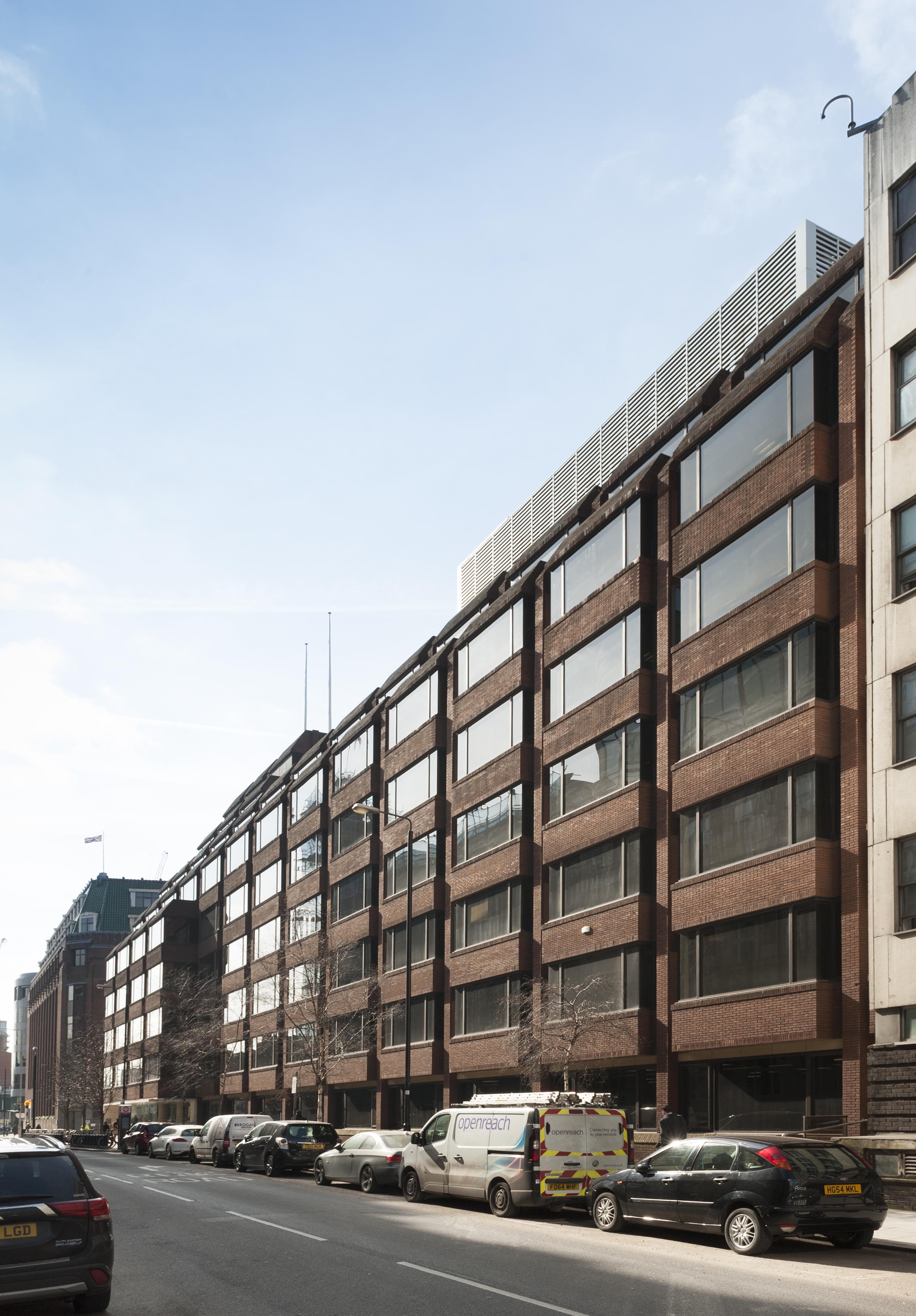
"title": "Maersk (formerly Beagle House), detail of east elevation",
"author": {
"id": 27,
"username": "DerekKendall"
},
"feature": {
"id": 31,
"type": "Feature",
"geometry": {
"type": "MultiPolygon",
"coordinates": [
[
[
[
-0.071887127893096,
51.51411332216963
],
[
-0.071969571208431,
51.51419942371175
],
[
-0.071924976063445,
51.5142326534243
],
[
-0.071948658834375,
51.51426657781599
],
[
-0.071835003267539,
51.5143227101345
],
[
-0.071686234045495,
51.5143855464125
],
[
-0.071543425125636,
51.514422007266134
],
[
-0.071435516621411,
51.51444471123646
],
[
-0.071395570736125,
51.51440565693606
],
[
-0.07134776228325,
51.51441310661883
],
[
-0.0712722588033,
51.51434177428325
],
[
-0.071303428297817,
51.51432370241673
],
[
-0.071263213192454,
51.5142868603796
],
[
-0.071374185885124,
51.514224080818835
],
[
-0.071528097019019,
51.51416207230522
],
[
-0.071692419185678,
51.51411901969061
],
[
-0.071795120500786,
51.514091351954804
],
[
-0.071848759931576,
51.5141216554061
],
[
-0.071887127893096,
51.51411332216963
]
]
]
]
},
"properties": {
"b_number": "1",
"b_name": "Maersk House",
"street": "Braham Street",
"address": "Maersk House (formerly Beagle House), 1 Braham Street",
"feature_type": "WHITECHAPEL_BUILDING",
"count": 20,
"search_str": "Maersk House"
},
"tags": []
},
"file": "https://surveyoflondon.org/media/uploads/features/31/SoL%20Whitechapel%20100456.jpg",
"description": "",
"copyright": true,
"created": "2017-04-10"
},
{
"id": 1244,
"title": "Cromlech House from the northeast in 2016",
"author": {
"id": 27,
"username": "DerekKendall"
},
"feature": {
"id": 1750,
"type": "Feature",
"geometry": {
"type": "MultiPolygon",
"coordinates": [
[
[
[
-0.074357471765638,
51.515414167283886
],
[
-0.074647451142337,
51.51530527967592
],
[
-0.074825683688237,
51.515219417372194
],
[
-0.075154885703515,
51.51546759153406
],
[
-0.074908107257318,
51.51561366922175
],
[
-0.074632742143565,
51.51569952442644
],
[
-0.074357471765638,
51.515414167283886
]
]
]
]
},
"properties": {
"b_number": "2-14",
"b_name": "Travelodge London City",
"street": "Middlesex Street",
"address": "20 Middlesex Street",
"feature_type": "WHITECHAPEL_BUILDING",
"count": 5,
"search_str": "Travelodge London City"
},
"tags": []
},
"file": "https://surveyoflondon.org/media/uploads/features/1750/SoL%20Whitechapel100303.jpg",
"description": "",
"copyright": true,
"created": "2018-04-17"
},
{
"id": 1166,
"title": "Docklands Action Centre 1980",
"author": {
"id": 153,
"username": "danny"
},
"feature": {
"id": 1367,
"type": "Feature",
"geometry": {
"type": "MultiPolygon",
"coordinates": [
[
[
[
-0.068280626941554,
51.51066731775845
],
[
-0.068304836027203,
51.51073531158041
],
[
-0.068245676894044,
51.510744647693585
],
[
-0.068229123218739,
51.51067344595373
],
[
-0.068280626941554,
51.51066731775845
]
]
]
]
},
"properties": {
"b_number": "2",
"b_name": "",
"street": "Cable Street",
"address": "2 Cable Street",
"feature_type": "WHITECHAPEL_BUILDING",
"count": 4,
"search_str": "2 Cable Street"
},
"tags": []
},
"file": "https://surveyoflondon.org/media/uploads/features/1367/Docklands%20Action%20Centre%201980.jpg",
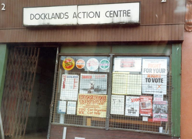
"description": "An image of the Docklands Action Centre at 2 Cable Street in 1980. A centre for activism in the area to try and ensure a better deal for local people, homes, jobs, consultation etc in the face of rampant development facilitated by the London Docklands Development Corporation, a Thatcher created Enterprise Zone set up to redevelop what were then London's derelict dockland areas east of and downriver from Tower Bridge.",
"copyright": false,
"created": "2018-03-04"
},
{
"id": 719,
"title": "Dock Street hostel with vicarage from the south-west in 2017",
"author": {
"id": 27,
"username": "DerekKendall"
},
"feature": {
"id": 1385,
"type": "Feature",
"geometry": {
"type": "MultiPolygon",
"coordinates": [
[
[
[
-0.067575803709333,
51.51021492278667
],
[
-0.067783647338447,
51.51017527172947
],
[
-0.067828706900756,
51.510167293395675
],
[
-0.067884358000762,
51.51028332470727
],
[
-0.068021222270461,
51.51026117174896
],
[
-0.068027105232624,
51.51027869995762
],
[
-0.068059007104689,
51.51027341168682
],
[
-0.068045803249401,
51.51025517119752
],
[
-0.068185711037114,
51.51022956959143
],
[
-0.068302205657116,
51.51049311218949
],
[
-0.068154065018083,
51.51051508999573
],
[
-0.068142111677326,
51.51048931210634
],
[
-0.068158013519995,
51.51048782991857
],
[
-0.0680993992664,
51.51035372697415
],
[
-0.068063773094401,
51.51035895389879
],
[
-0.068055396596396,
51.510336723241444
],
[
-0.067963562571312,
51.510349163498944
],
[
-0.067961653646245,
51.510339150568754
],
[
-0.067909585576321,
51.510347692789416
],
[
-0.067933270683552,
51.5104044774377
],
[
-0.067674158297256,
51.51045078856997
],
[
-0.067629160671485,
51.51036923447038
],
[
-0.067652633918951,
51.51036497018876
],
[
-0.067575803709333,
51.51021492278667
]
]
]
]
},
"properties": {
"b_number": "7",
"b_name": "",
"street": "Dock Street",
"address": "Wombat's City Hostel, 7 Dock Street",
"feature_type": "WHITECHAPEL_BUILDING",
"count": 25,
"search_str": "Wombat's City Hostel, 7 Dock Street"
},
"tags": []
},
"file": "https://surveyoflondon.org/media/uploads/features/1385/SoL%20Whitechapel%20101146.jpg",
"description": "",
"copyright": true,
"created": "2017-08-02"
},
{
"id": 1127,
"title": "Brady Boys' Club (1936-8, Messrs Joseph)",
"author": {
"id": 2,
"username": "surveyoflondon"
},
"feature": {
"id": 611,
"type": "Feature",
"geometry": {
"type": "MultiPolygon",
"coordinates": [
[
[
[
-0.061071171968994,
51.52081854756523
],
[
-0.060751914384132,
51.520910345673705
],
[
-0.060670800177771,
51.520804404847986
],
[
-0.060468455213489,
51.52086122248221
],
[
-0.060450699740395,
51.52083834953325
],
[
-0.060348963469709,
51.52086716970229
],
[
-0.060327054268411,
51.52084002855742
],
[
-0.060218088338048,
51.52087362145146
],
[
-0.060181870551264,
51.52082767044763
],
[
-0.059888941340425,
51.5209177401419
],
[
-0.059906837511582,
51.520944348074295
],
[
-0.059794155620414,
51.52097953029167
],
[
-0.059832243956796,
51.521028790808174
],
[
-0.059621239031678,
51.52108457365709
],
[
-0.059750656156039,
51.521261628315195
],
[
-0.060092261050819,
51.521162518995624
],
[
-0.060201267294625,
51.5213109827491
],
[
-0.059711284021543,
51.521455446025634
],
[
-0.059608494153443,
51.52131130869682
],
[
-0.059508393196664,
51.521340050168135
],
[
-0.059253117703057,
51.52099166668332
],
[
-0.059256033768267,
51.5209595242491
],
[
-0.059159886666936,
51.520817675044256
],
[
-0.059263515528805,
51.520783743654874
],
[
-0.059005942108209,
51.52046133162211
],
[
-0.059340108320742,
51.520363660572684
],
[
-0.059350977165626,
51.520379010450526
],
[
-0.059653760593448,
51.52029256187745
],
[
-0.059732700862836,
51.52040478191169
],
[
-0.059399004206541,
51.520507265410146
],
[
-0.059386008017351,
51.52050099774739
],
[
-0.059330111279166,
51.52051942249526
],
[
-0.059427473319942,
51.520650551502136
],
[
-0.059335113114943,
51.52067740335036
],
[
-0.059393880270447,
51.52075719296283
],
[
-0.059578966698866,
51.52070547069434
],
[
-0.059521505013312,
51.5206204479455
],
[
-0.059633019030968,
51.52058917356787
],
[
-0.05965569761926,
51.52061535612946
],
[
-0.059758050698807,
51.52058539506149
],
[
-0.059784825395434,
51.520617287071275
],
[
-0.059896250945807,
51.520586175310825
],
[
-0.059905010512797,
51.5206001008183
],
[
-0.060207891820099,
51.520512562603464
],
[
-0.060152819128302,
51.52043377382353
],
[
-0.060255799218263,
51.520404384952066
],
[
-0.060243948876997,
51.520387831372716
],
[
-0.060374285949892,
51.52035112116383
],
[
-0.06040163767932,
51.52038826992398
],
[
-0.060493821347423,
51.520361732013576
],
[
-0.060585729284775,
51.52048450453705
],
[
-0.060667847773396,
51.520461046936504
],
[
-0.060740712007704,
51.520573214734334
],
[
-0.060789668351451,
51.52055928381185
],
[
-0.060862533037535,
51.52067145153698
],
[
-0.060908498405939,
51.52065859991671
],
[
-0.06094600415928,
51.52070981388415
],
[
-0.060904572245245,
51.52072152762277
],
[
-0.060915563003104,
51.5207389782457
],
[
-0.06100155865022,
51.52071591478786
],
[
-0.061071171968994,
51.52081854756523
]
]
]
]
},
"properties": {
"b_number": "",
"b_name": "Swanlea Secondary School",
"street": "Brady Street",
"address": "Swanlea Secondary School, Brady Street and Durward Street",
"feature_type": "WHITECHAPEL_BUILDING",
"count": 20,
"search_str": "Swanlea Secondary School"
},
"tags": []
},
"file": "https://surveyoflondon.org/media/uploads/features/611/Brady%20Street%20Boys%20Club.jpg",
"description": "",
"copyright": false,
"created": "2018-02-12"
},
{
"id": 387,
"title": "United Standard House and Cromlech House with market stall frames on Goulston Street in 2016",
"author": {
"id": 27,
"username": "DerekKendall"
},
"feature": {
"id": 350,
"type": "Feature",
"geometry": {
"type": "MultiPolygon",
"coordinates": [
[
[
[
-0.074647451142337,
51.51530527967592
],
[
-0.074357471765638,
51.515414167283886
],
[
-0.073990659509213,
51.51505709668585
],
[
-0.074395588069206,
51.514895160577964
],
[
-0.074663489419344,
51.51509835683479
],
[
-0.074491595155131,
51.515179363370244
],
[
-0.074647451142337,
51.51530527967592
]
]
]
]
},
"properties": {
"b_number": "2-14",
"b_name": "United Standard House",
"street": "Middlesex Street",
"address": "2 to 14 Middlesex Street",
"feature_type": "WHITECHAPEL_BUILDING",
"count": 16,
"search_str": "United Standard House"
},
"tags": []
},
"file": "https://surveyoflondon.org/media/uploads/features/350/SoL%20Whitechapel100302.jpg",
"description": "",
"copyright": true,
"created": "2016-09-13"
},
{
"id": 1248,
"title": "New Road Hotel, detail in May 2018",
"author": {
"id": 27,
"username": "DerekKendall"
},
"feature": {
"id": 849,
"type": "Feature",
"geometry": {
"type": "MultiPolygon",
"coordinates": [
[
[
[
-0.062609929785488,
51.51738959779921
],
[
-0.062716406528659,
51.51737667042908
],
[
-0.062723861521385,
51.51740458896256
],
[
-0.062817127286198,
51.51739512872249
],
[
-0.062863455061319,
51.51757291139632
],
[
-0.062766096607894,
51.517621918848995
],
[
-0.062677693069574,
51.517634076942514
],
[
-0.062609929785488,
51.51738959779921
]
]
]
]
},
"properties": {
"b_number": "101-107",
"b_name": "",
"street": "New Road",
"address": "New Road Hotel (formerly Service House), 101-107 New Road",
"feature_type": "WHITECHAPEL_BUILDING",
"count": 9,
"search_str": "New Road Hotel (formerly Service House), 101-107 New Road"
},
"tags": [
"H. Victor Kerr"
]
},
"file": "https://surveyoflondon.org/media/uploads/features/849/SoL%20Whitechapel%20101998.jpg",
"description": "",
"copyright": true,
"created": "2018-05-10"
},
{
"id": 1249,
"title": "111 New Road, looking south-west in May 2018",
"author": {
"id": 27,
"username": "DerekKendall"
},
"feature": {
"id": 951,
"type": "Feature",
"geometry": {
"type": "MultiPolygon",
"coordinates": [
[
[
[
-0.062701947682249,
51.51772182914312
],
[
-0.062688065502303,
51.51767311536834
],
[
-0.062996334191166,
51.51759704267358
],
[
-0.063025709537611,
51.51764418006528
],
[
-0.062701947682249,
51.51772182914312
]
]
]
]
},
"properties": {
"b_number": "111",
"b_name": "",
"street": "New Road",
"address": "111 New Road",
"feature_type": "WHITECHAPEL_BUILDING",
"count": 6,
"search_str": "111 New Road"
},
"tags": []
},
"file": "https://surveyoflondon.org/media/uploads/features/951/SoL%20Whitechapel%20101999.jpg",
"description": "",
"copyright": true,
"created": "2018-05-10"
},
{
"id": 1250,
"title": "109 and 111 New Road in May 2018",
"author": {
"id": 27,
"username": "DerekKendall"
},
"feature": {
"id": 951,
"type": "Feature",
"geometry": {
"type": "MultiPolygon",
"coordinates": [
[
[
[
-0.062701947682249,
51.51772182914312
],
[
-0.062688065502303,
51.51767311536834
],
[
-0.062996334191166,
51.51759704267358
],
[
-0.063025709537611,
51.51764418006528
],
[
-0.062701947682249,
51.51772182914312
]
]
]
]
},
"properties": {
"b_number": "111",
"b_name": "",
"street": "New Road",
"address": "111 New Road",
"feature_type": "WHITECHAPEL_BUILDING",
"count": 6,
"search_str": "111 New Road"
},
"tags": []
},
"file": "https://surveyoflondon.org/media/uploads/features/951/SoL%20Whitechapel%20102001.jpg",
"description": "",
"copyright": true,
"created": "2018-05-10"
},
{
"id": 1251,
"title": "109-113 New Road in May 2018",
"author": {
"id": 27,
"username": "DerekKendall"
},
"feature": {
"id": 951,
"type": "Feature",
"geometry": {
"type": "MultiPolygon",
"coordinates": [
[
[
[
-0.062701947682249,
51.51772182914312
],
[
-0.062688065502303,
51.51767311536834
],
[
-0.062996334191166,
51.51759704267358
],
[
-0.063025709537611,
51.51764418006528
],
[
-0.062701947682249,
51.51772182914312
]
]
]
]
},
"properties": {
"b_number": "111",
"b_name": "",
"street": "New Road",
"address": "111 New Road",
"feature_type": "WHITECHAPEL_BUILDING",
"count": 6,
"search_str": "111 New Road"
},
"tags": []
},
"file": "https://surveyoflondon.org/media/uploads/features/951/SoL%20Whitechapel%20102002.jpg",
"description": "",
"copyright": true,
"created": "2018-05-10"
},
{
"id": 1404,
"title": "19 Dock Street in the early 1970s (photograph by Dan Cruickshank)",
"author": {
"id": 268,
"username": "DanCruickshank"
},
"feature": {
"id": 1374,
"type": "Feature",
"geometry": {
"type": "MultiPolygon",
"coordinates": [
[
[
[
-0.067711398877156,
51.50924604425161
],
[
-0.067756321842336,
51.50932934126646
],
[
-0.067652923901106,
51.50935089289648
],
[
-0.067609764836991,
51.509269950451625
],
[
-0.067711398877156,
51.50924604425161
]
]
]
]
},
"properties": {
"b_number": "19",
"b_name": "",
"street": "Dock Street",
"address": "19 Dock Street",
"feature_type": "WHITECHAPEL_BUILDING",
"count": 6,
"search_str": "19 Dock Street"
},
"tags": []
},
"file": "https://surveyoflondon.org/media/uploads/features/1374/00410006.jpg",
"description": "",
"copyright": true,
"created": "2018-11-13"
},
{
"id": 1216,
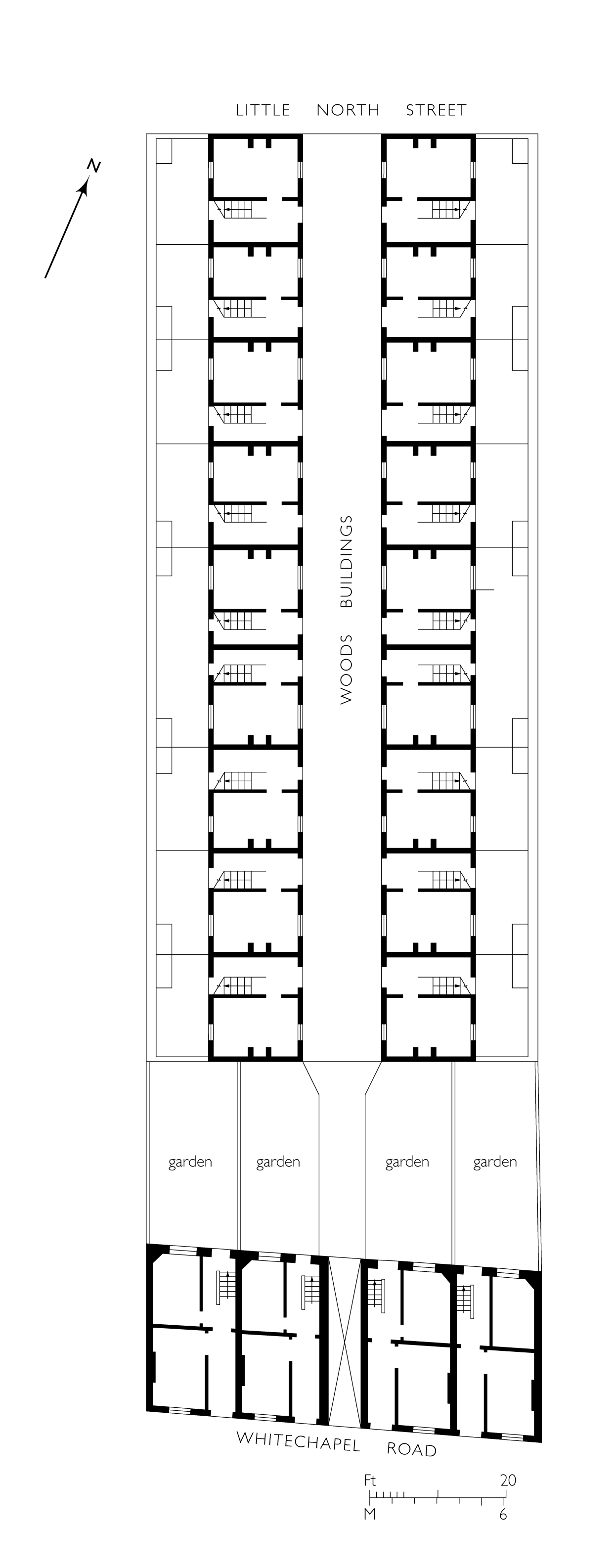
"title": "261–267 Whitechapel Road and Woods Buildings, plan at ground-floor level, reconstructed as built in 1767–72",
"author": {
"id": 82,
"username": "HelenJones"
},
"feature": {
"id": 492,
"type": "Feature",
"geometry": {
"type": "MultiPolygon",
"coordinates": [
[
[
[
-0.060403279664518,
51.51930247737293
],
[
-0.060301507160973,
51.51915965550755
],
[
-0.060361409790916,
51.519146122160706
],
[
-0.060459680582034,
51.519288003680906
],
[
-0.060403279664518,
51.51930247737293
]
]
]
]
},
"properties": {
"b_number": "261",
"b_name": "",
"street": "Whitechapel Road",
"address": "261 Whitechapel Road",
"feature_type": "WHITECHAPEL_BUILDING",
"count": 3,
"search_str": "261 Whitechapel Road"
},
"tags": []
},
"file": "https://surveyoflondon.org/media/uploads/features/492/261-267%20plan.jpg",
"description": "",
"copyright": true,
"created": "2018-03-20"
},
{
"id": 1217,
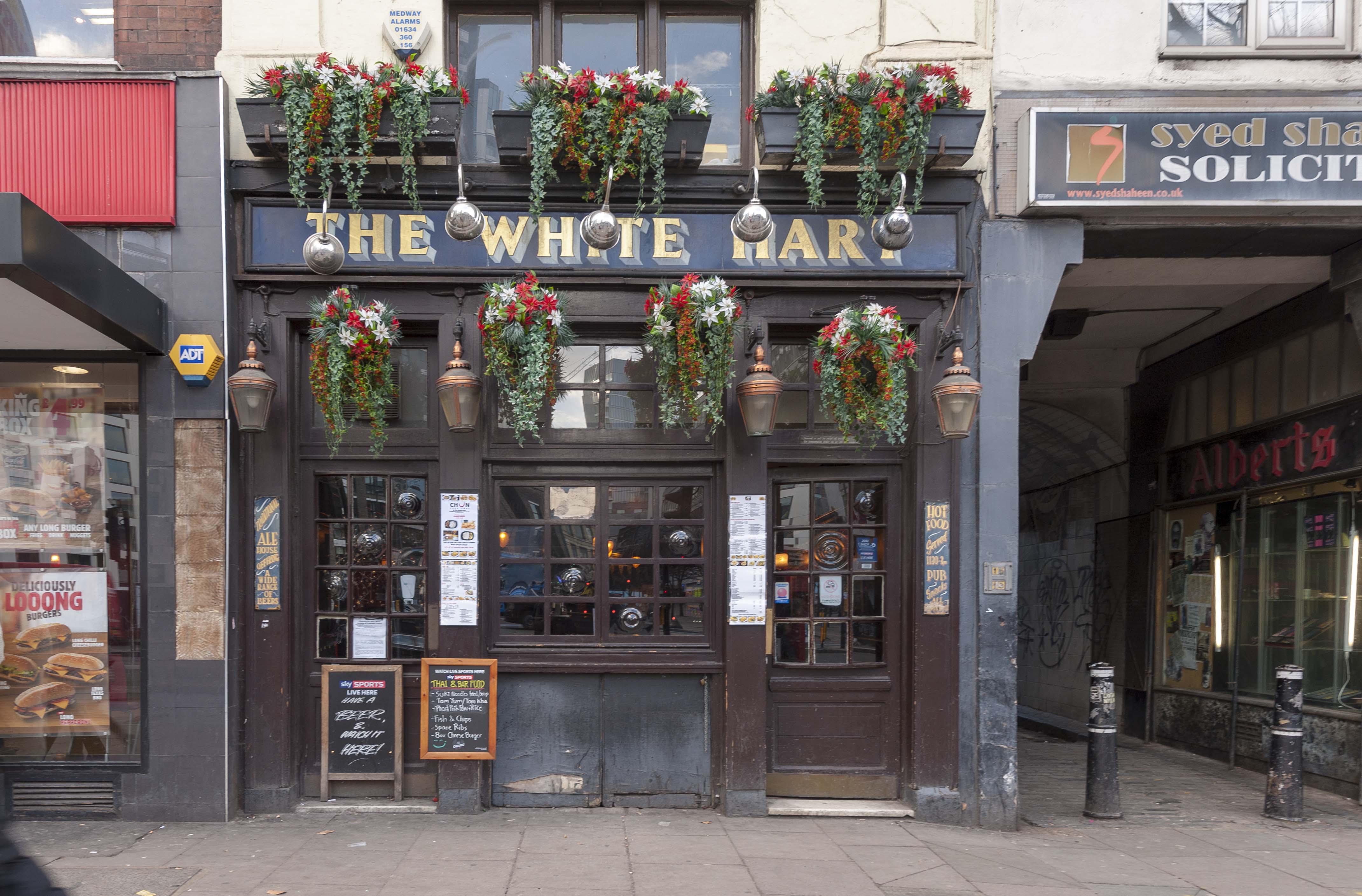
"title": "High Street frontage of the White Hart, February 2018",
"author": {
"id": 27,
"username": "DerekKendall"
},
"feature": {
"id": 321,
"type": "Feature",
"geometry": {
"type": "MultiPolygon",
"coordinates": [
[
[
[
-0.070851482033923,
51.51583890438921
],
[
-0.070769983901351,
51.515756150681995
],
[
-0.070826096590134,
51.51573168194945
],
[
-0.070910018893456,
51.51581372858656
],
[
-0.070987330377172,
51.51589641332654
],
[
-0.071038807895081,
51.515953523899796
],
[
-0.070962773338145,
51.515980152176006
],
[
-0.070839633171055,
51.51584349573393
],
[
-0.070851482033923,
51.51583890438921
]
]
]
]
},
"properties": {
"b_number": "89",
"b_name": "White Hart, 89 Whitechapel High Street",
"street": "Whitechapel High Street",
"address": "White Hart, 89 Whitechapel High Street, London E1",
"feature_type": "WHITECHAPEL_BUILDING",
"count": 9,
"search_str": "White Hart, 89 Whitechapel High Street"
},
"tags": []
},
"file": "https://surveyoflondon.org/media/uploads/features/321/SoL%20Whitechapel%20101862.jpg",
"description": "",
"copyright": true,
"created": "2018-03-22"
},
{
"id": 1225,
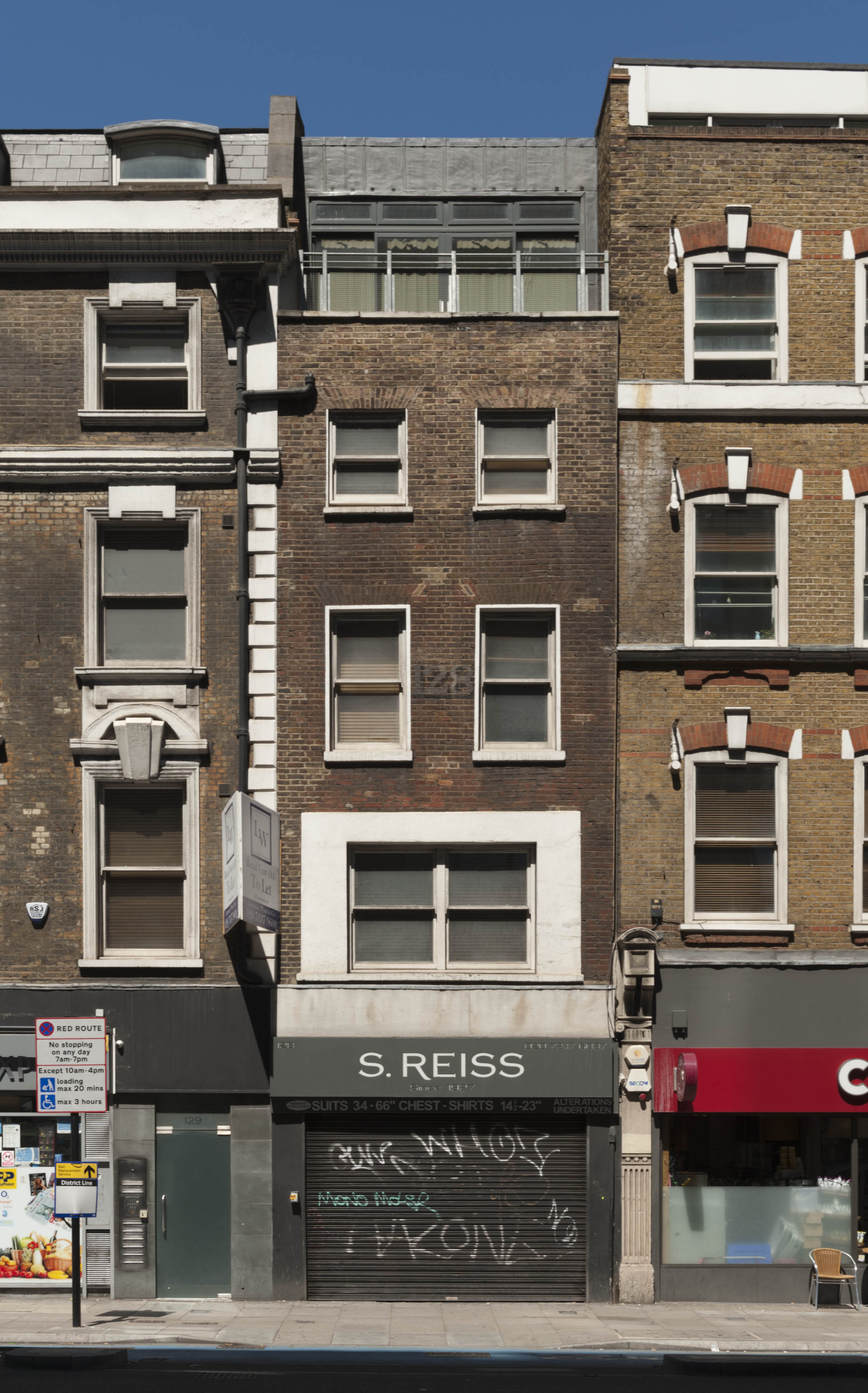
"title": "No 128 High Street in June 2017",
"author": {
"id": 27,
"username": "DerekKendall"
},
"feature": {
"id": 407,
"type": "Feature",
"geometry": {
"type": "MultiPolygon",
"coordinates": [
[
[
[
-0.072950273191856,
51.51493052559777
],
[
-0.073018678415549,
51.51490651384565
],
[
-0.073178701087915,
51.515075886403494
],
[
-0.073123499137516,
51.51509849896724
],
[
-0.072950273191856,
51.51493052559777
]
]
]
]
},
"properties": {
"b_number": "128",
"b_name": "",
"street": "Whitechapel High Street",
"address": "128 Whitechapel High Street, London E1 7PT",
"feature_type": "WHITECHAPEL_BUILDING",
"count": 5,
"search_str": "128 Whitechapel High Street, London E1 7PT"
},
"tags": []
},
"file": "https://surveyoflondon.org/media/uploads/features/407/SoL%20Whitechapel%20100967.jpg",
"description": "",
"copyright": true,
"created": "2018-03-22"
}
]
}
.jpg)