HTTP 200 OK
Allow: GET, HEAD, OPTIONS
Content-Type: application/json
Vary: Accept
{
"count": 1747,
"next": "https://surveyoflondon.org/api/v1/images/?format=api&page=57",
"previous": "https://surveyoflondon.org/api/v1/images/?format=api&page=55",
"results": [
{
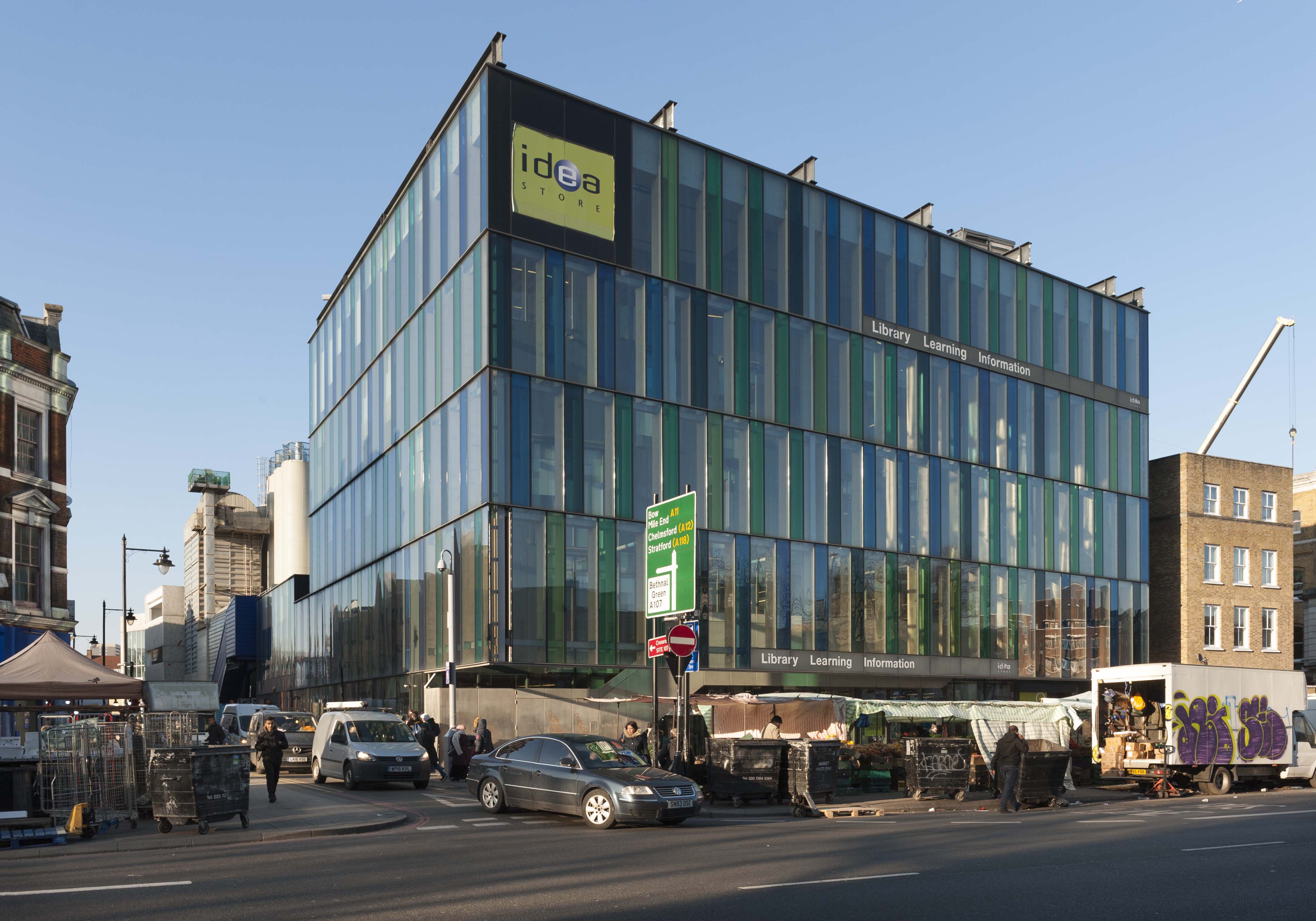
"id": 1196,
"title": "Whitechapel Idea Store from the south in early 2018",
"author": {
"id": 27,
"username": "DerekKendall"
},
"feature": {
"id": 518,
"type": "Feature",
"geometry": {
"type": "MultiPolygon",
"coordinates": [
[
[
[
-0.058265578249493,
51.51997368190386
],
[
-0.057870681883353,
51.520069776330836
],
[
-0.057795852846717,
51.519925640296286
],
[
-0.057754684632276,
51.51993713160212
],
[
-0.057648441439835,
51.519761149535064
],
[
-0.05807295251591,
51.51962908276924
],
[
-0.058265578249493,
51.51997368190386
]
]
]
]
},
"properties": {
"b_number": "321",
"b_name": "Whitechapel Idea Store",
"street": "Whitechapel Road",
"address": "Whitechapel Idea Store, 321 Whitechapel Road",
"feature_type": "WHITECHAPEL_BUILDING",
"count": 15,
"search_str": "Whitechapel Idea Store"
},
"tags": [
"David Adjaye",
"James Edmeston",
"John Samuel Hayward"
]
},
"file": "https://surveyoflondon.org/media/uploads/features/518/SoL%20Whitechapel%20101838.jpg",
"description": "",
"copyright": true,
"created": "2018-03-05"
},
{
"id": 1164,
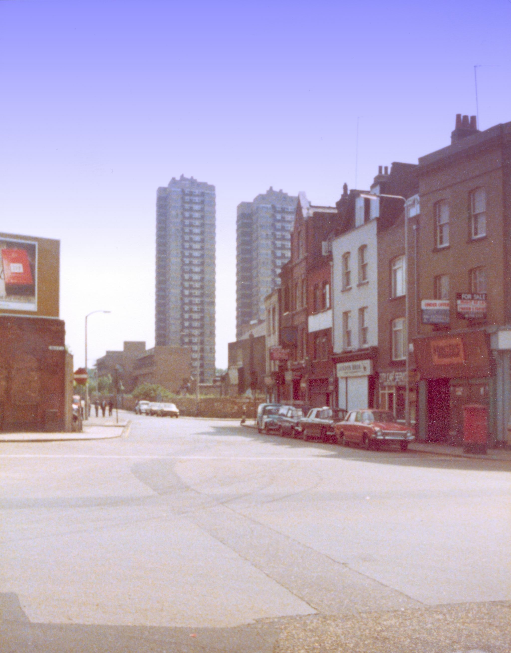
"title": "Cable St junction Dock Street 1980",
"author": {
"id": 153,
"username": "danny"
},
"feature": {
"id": 1368,
"type": "Feature",
"geometry": {
"type": "MultiPolygon",
"coordinates": [
[
[
[
-0.068304836027203,
51.51073531158041
],
[
-0.068280626941554,
51.51066731775845
],
[
-0.068273645510051,
51.51064349252156
],
[
-0.068344140610016,
51.51063057393707
],
[
-0.068360428462064,
51.51067502754345
],
[
-0.068363636587595,
51.51068728948646
],
[
-0.068362263104961,
51.510697731803
],
[
-0.068356160539397,
51.5107098403773
],
[
-0.068349825933683,
51.51071642196578
],
[
-0.068338811399467,
51.5107235078495
],
[
-0.068328323844215,
51.5107291489489
],
[
-0.068318877871198,
51.510733223642234
],
[
-0.068304836027203,
51.51073531158041
]
]
]
]
},
"properties": {
"b_number": "1",
"b_name": "",
"street": "Dock Street",
"address": "1 Dock Street",
"feature_type": "WHITECHAPEL_BUILDING",
"count": 8,
"search_str": "1 Dock Street"
},
"tags": []
},
"file": "https://surveyoflondon.org/media/uploads/features/1368/Dock%20Street%20Cable%20Street.jpg",
"description": "Cable Street at its junction with Leman Street and Dock Street circa 1980 - note Ford Corsair in foreground and Koiki's shop by then the Docklands Resource Centre. Shearsmith House on the St George's Estate can be seen towering over the scene in the background. On the left of the picture are the walls of the former Leman Street railway station.",
"copyright": false,
"created": "2018-03-04"
},
{
"id": 1003,
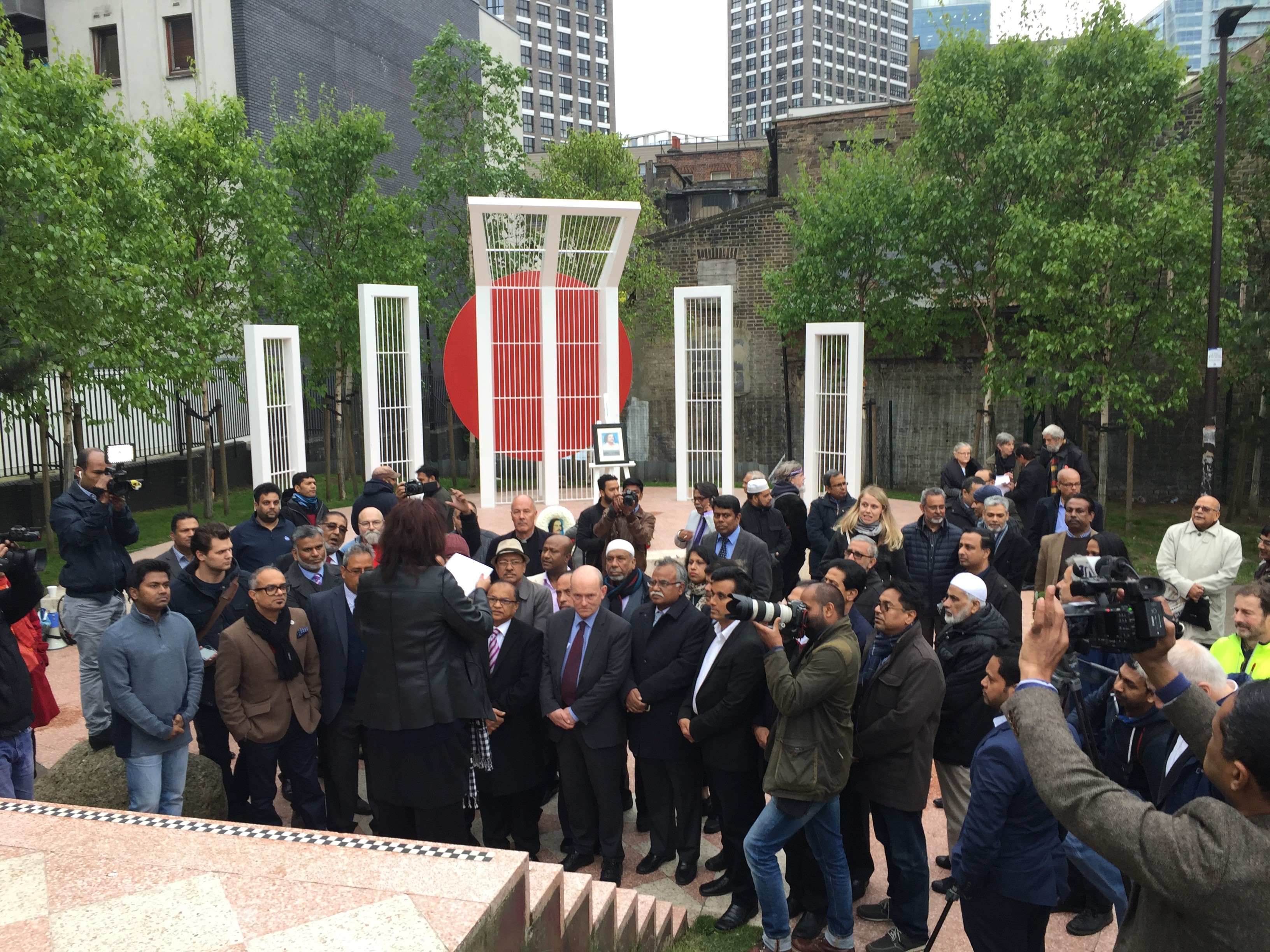
"title": "Altab Ali Day 2017",
"author": {
"id": 212,
"username": "AnsarAhmedUllah"
},
"feature": {
"id": 296,
"type": "Feature",
"geometry": {
"type": "MultiPolygon",
"coordinates": [
[
[
[
-0.069238538289603,
51.51610506120929
],
[
-0.069007097235987,
51.5162239535272
],
[
-0.068282200256798,
51.51654369745104
],
[
-0.068157401560378,
51.51641994527148
],
[
-0.067807959279103,
51.51600137496063
],
[
-0.068541180339468,
51.515783257348254
],
[
-0.068555919008956,
51.51580580160597
],
[
-0.068713893455475,
51.515872451567986
],
[
-0.068778503699218,
51.51586114158782
],
[
-0.068817146392177,
51.515922550138725
],
[
-0.068888047037903,
51.51596428315636
],
[
-0.069016085124709,
51.515921053627785
],
[
-0.069107698271647,
51.51601562404751
],
[
-0.069243279190738,
51.515974904669626
],
[
-0.069238538289603,
51.51610506120929
]
]
]
]
},
"properties": {
"b_number": "",
"b_name": "Altab Ali Park, including the site of the parish church of St Mary Matfelon",
"street": "Whitechapel Road",
"address": "Altab Ali Park",
"feature_type": "OPEN_SPACE",
"count": 32,
"search_str": "Altab Ali Park, including the site of the parish church of St Mary Matfelon"
},
"tags": []
},
"file": "https://surveyoflondon.org/media/uploads/features/296/Altab%20Ali%20Day%204%20May%2017.jpg%2013.jpg",
"description": "Richard Humm, a local resident/activist and member of Cable Street Group, and Ansar Ahmed Ullah, of Swadhinata Trust.\n\n2017 Photo Ansar Ahmed Ullah",
"copyright": true,
"created": "2018-01-06"
},
{
"id": 682,
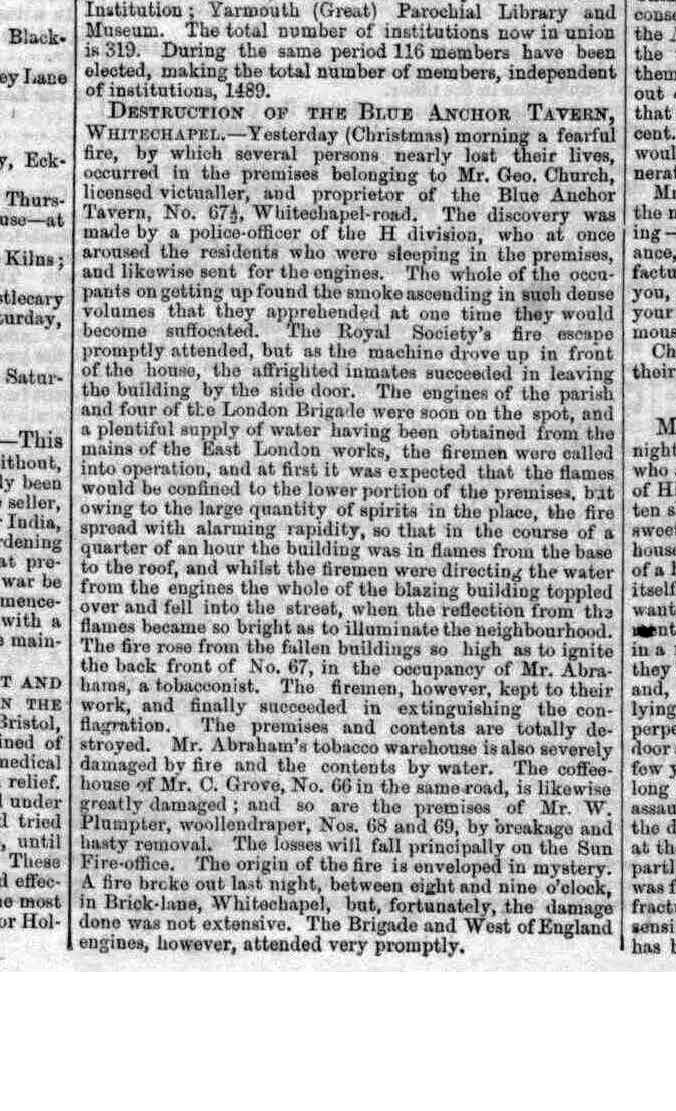
"title": "Fire at the Blue Anchor Tavern Christmas Day 1853",
"author": {
"id": 158,
"username": "Caroline_Church"
},
"feature": {
"id": 437,
"type": "Feature",
"geometry": {
"type": "MultiPolygon",
"coordinates": [
[
[
[
-0.065795294340421,
51.51786534440968
],
[
-0.065746488420915,
51.517884201539125
],
[
-0.065653063212912,
51.517780108099075
],
[
-0.065725498229974,
51.51775563906246
],
[
-0.065813903711342,
51.517858154302715
],
[
-0.065795294340421,
51.51786534440968
]
]
]
]
},
"properties": {
"b_number": "133",
"b_name": "",
"street": "Whitechapel Road",
"address": "Bar Indo (formerly the Blue Anchor Public House), 133 Whitechapel Road",
"feature_type": "WHITECHAPEL_BUILDING",
"count": 10,
"search_str": "Bar Indo (formerly the Blue Anchor Public House), 133 Whitechapel Road"
},
"tags": []
},
"file": "https://surveyoflondon.org/media/uploads/features/437/The%20London%20Standard%20December%2026th%201853.jpg",
"description": "My great great grandfather George Church was the proprietor of the Blue Anchor Tavern from 1848 till 1874. The original building was destroyed by fire on Christmas morning 1853, in a large blaze described by the London Standard as 'enveloped in mystery'. It was rebuilt the following year, after a substantial payout from the Sun Fire Office. Several other buildings adjoining were also badly damaged or destroyed. The original address was 67 or 671/2 Whitechapel Road, before the numbering system was changed.",
"copyright": false,
"created": "2017-06-07"
},
{
"id": 732,
"title": "On the landing at Brady Street Dwellings",
"author": {
"id": 181,
"username": "mick"
},
"feature": {
"id": 611,
"type": "Feature",
"geometry": {
"type": "MultiPolygon",
"coordinates": [
[
[
[
-0.061071171968994,
51.52081854756523
],
[
-0.060751914384132,
51.520910345673705
],
[
-0.060670800177771,
51.520804404847986
],
[
-0.060468455213489,
51.52086122248221
],
[
-0.060450699740395,
51.52083834953325
],
[
-0.060348963469709,
51.52086716970229
],
[
-0.060327054268411,
51.52084002855742
],
[
-0.060218088338048,
51.52087362145146
],
[
-0.060181870551264,
51.52082767044763
],
[
-0.059888941340425,
51.5209177401419
],
[
-0.059906837511582,
51.520944348074295
],
[
-0.059794155620414,
51.52097953029167
],
[
-0.059832243956796,
51.521028790808174
],
[
-0.059621239031678,
51.52108457365709
],
[
-0.059750656156039,
51.521261628315195
],
[
-0.060092261050819,
51.521162518995624
],
[
-0.060201267294625,
51.5213109827491
],
[
-0.059711284021543,
51.521455446025634
],
[
-0.059608494153443,
51.52131130869682
],
[
-0.059508393196664,
51.521340050168135
],
[
-0.059253117703057,
51.52099166668332
],
[
-0.059256033768267,
51.5209595242491
],
[
-0.059159886666936,
51.520817675044256
],
[
-0.059263515528805,
51.520783743654874
],
[
-0.059005942108209,
51.52046133162211
],
[
-0.059340108320742,
51.520363660572684
],
[
-0.059350977165626,
51.520379010450526
],
[
-0.059653760593448,
51.52029256187745
],
[
-0.059732700862836,
51.52040478191169
],
[
-0.059399004206541,
51.520507265410146
],
[
-0.059386008017351,
51.52050099774739
],
[
-0.059330111279166,
51.52051942249526
],
[
-0.059427473319942,
51.520650551502136
],
[
-0.059335113114943,
51.52067740335036
],
[
-0.059393880270447,
51.52075719296283
],
[
-0.059578966698866,
51.52070547069434
],
[
-0.059521505013312,
51.5206204479455
],
[
-0.059633019030968,
51.52058917356787
],
[
-0.05965569761926,
51.52061535612946
],
[
-0.059758050698807,
51.52058539506149
],
[
-0.059784825395434,
51.520617287071275
],
[
-0.059896250945807,
51.520586175310825
],
[
-0.059905010512797,
51.5206001008183
],
[
-0.060207891820099,
51.520512562603464
],
[
-0.060152819128302,
51.52043377382353
],
[
-0.060255799218263,
51.520404384952066
],
[
-0.060243948876997,
51.520387831372716
],
[
-0.060374285949892,
51.52035112116383
],
[
-0.06040163767932,
51.52038826992398
],
[
-0.060493821347423,
51.520361732013576
],
[
-0.060585729284775,
51.52048450453705
],
[
-0.060667847773396,
51.520461046936504
],
[
-0.060740712007704,
51.520573214734334
],
[
-0.060789668351451,
51.52055928381185
],
[
-0.060862533037535,
51.52067145153698
],
[
-0.060908498405939,
51.52065859991671
],
[
-0.06094600415928,
51.52070981388415
],
[
-0.060904572245245,
51.52072152762277
],
[
-0.060915563003104,
51.5207389782457
],
[
-0.06100155865022,
51.52071591478786
],
[
-0.061071171968994,
51.52081854756523
]
]
]
]
},
"properties": {
"b_number": "",
"b_name": "Swanlea Secondary School",
"street": "Brady Street",
"address": "Swanlea Secondary School, Brady Street and Durward Street",
"feature_type": "WHITECHAPEL_BUILDING",
"count": 20,
"search_str": "Swanlea Secondary School"
},
"tags": []
},
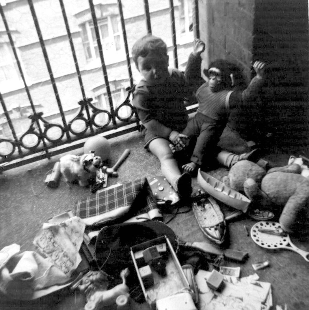
"file": "https://surveyoflondon.org/media/uploads/features/611/1963%20On%20landing%20with%20toys.JPG",
"description": "Playing with my toys on the top floor (we lived at No. 143)",
"copyright": false,
"created": "2017-08-09"
},
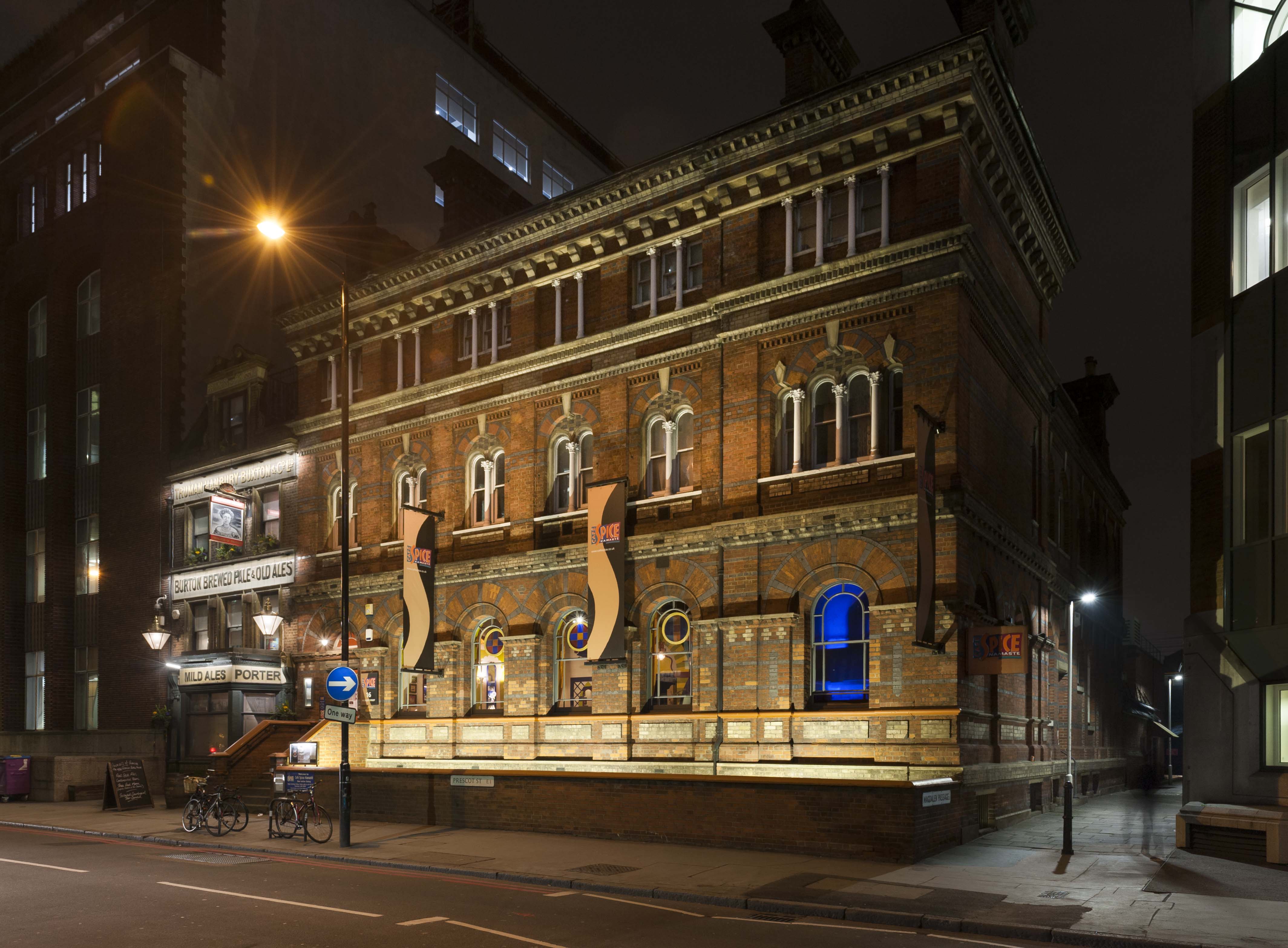
{
"id": 1190,
"title": "16 Prescot Street in early 2018, from the north-west",
"author": {
"id": 27,
"username": "DerekKendall"
},
"feature": {
"id": 1291,
"type": "Feature",
"geometry": {
"type": "MultiPolygon",
"coordinates": [
[
[
[
-0.070839769786207,
51.511534824904025
],
[
-0.070585471149656,
51.51157481222347
],
[
-0.07051545384739,
51.51139090854125
],
[
-0.070759436998916,
51.511351044073685
],
[
-0.070839769786207,
51.511534824904025
]
]
]
]
},
"properties": {
"b_number": "16",
"b_name": "",
"street": "Prescot Street",
"address": "16 Prescot Street",
"feature_type": "WHITECHAPEL_BUILDING",
"count": 4,
"search_str": "16 Prescot Street"
},
"tags": []
},
"file": "https://surveyoflondon.org/media/uploads/features/1291/SoL%20Whitechapel%20101813.jpg",
"description": "",
"copyright": true,
"created": "2018-03-05"
},
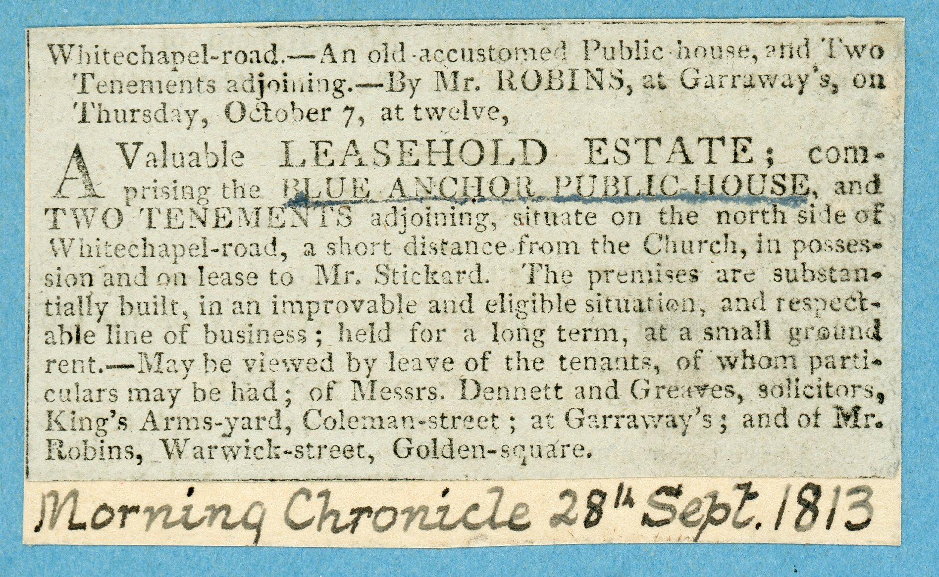
{
"id": 470,
"title": "Cutting concerning the Blue Anchor, Whitechapel Road 1813",
"author": {
"id": 87,
"username": "THLocalHistoryLibrary"
},
"feature": {
"id": 437,
"type": "Feature",
"geometry": {
"type": "MultiPolygon",
"coordinates": [
[
[
[
-0.065795294340421,
51.51786534440968
],
[
-0.065746488420915,
51.517884201539125
],
[
-0.065653063212912,
51.517780108099075
],
[
-0.065725498229974,
51.51775563906246
],
[
-0.065813903711342,
51.517858154302715
],
[
-0.065795294340421,
51.51786534440968
]
]
]
]
},
"properties": {
"b_number": "133",
"b_name": "",
"street": "Whitechapel Road",
"address": "Bar Indo (formerly the Blue Anchor Public House), 133 Whitechapel Road",
"feature_type": "WHITECHAPEL_BUILDING",
"count": 10,
"search_str": "Bar Indo (formerly the Blue Anchor Public House), 133 Whitechapel Road"
},
"tags": []
},
"file": "https://surveyoflondon.org/media/uploads/features/437/Blue%20Anchor%201813%20600%20dpi130.jpg",
"description": "Cutting from the collection of Tower Hamlets Local History Library & Archives filed at 653.1, taken from The Morning Chronicle 28th September 1813.",
"copyright": false,
"created": "2016-12-19"
},
{
"id": 1353,
"title": "95–96 Whitechapel High Street in 2018",
"author": {
"id": 27,
"username": "DerekKendall"
},
"feature": {
"id": 324,
"type": "Feature",
"geometry": {
"type": "MultiPolygon",
"coordinates": [
[
[
[
-0.071221521925884,
51.51567779628602
],
[
-0.071143174809878,
51.515605203446455
],
[
-0.071275135083496,
51.51555119423484
],
[
-0.071410095027146,
51.51567897800618
],
[
-0.071277088715054,
51.51573533768472
],
[
-0.071221521925884,
51.51567779628602
]
]
]
]
},
"properties": {
"b_number": "95-6",
"b_name": "95-6 Whitechapel High Street",
"street": "Whitechapel High Street",
"address": "95-6 Whitechapel High Street, London E1 7RA",
"feature_type": "WHITECHAPEL_BUILDING",
"count": 4,
"search_str": "95-6 Whitechapel High Street"
},
"tags": []
},
"file": "https://surveyoflondon.org/media/uploads/features/324/SoL%20Whitechapel%20102211.jpg",
"description": "",
"copyright": true,
"created": "2018-10-10"
},
{
"id": 1354,
"title": "90–96 Whitechapel High Street from the southwest in 2018",
"author": {
"id": 27,
"username": "DerekKendall"
},
"feature": {
"id": 324,
"type": "Feature",
"geometry": {
"type": "MultiPolygon",
"coordinates": [
[
[
[
-0.071221521925884,
51.51567779628602
],
[
-0.071143174809878,
51.515605203446455
],
[
-0.071275135083496,
51.51555119423484
],
[
-0.071410095027146,
51.51567897800618
],
[
-0.071277088715054,
51.51573533768472
],
[
-0.071221521925884,
51.51567779628602
]
]
]
]
},
"properties": {
"b_number": "95-6",
"b_name": "95-6 Whitechapel High Street",
"street": "Whitechapel High Street",
"address": "95-6 Whitechapel High Street, London E1 7RA",
"feature_type": "WHITECHAPEL_BUILDING",
"count": 4,
"search_str": "95-6 Whitechapel High Street"
},
"tags": []
},
"file": "https://surveyoflondon.org/media/uploads/features/324/SoL%20Whitechapel%20102210.jpg",
"description": "",
"copyright": true,
"created": "2018-10-10"
},
{
"id": 1355,
"title": "90–96 Whitechapel High Street from the south in 2018",
"author": {
"id": 27,
"username": "DerekKendall"
},
"feature": {
"id": 324,
"type": "Feature",
"geometry": {
"type": "MultiPolygon",
"coordinates": [
[
[
[
-0.071221521925884,
51.51567779628602
],
[
-0.071143174809878,
51.515605203446455
],
[
-0.071275135083496,
51.51555119423484
],
[
-0.071410095027146,
51.51567897800618
],
[
-0.071277088715054,
51.51573533768472
],
[
-0.071221521925884,
51.51567779628602
]
]
]
]
},
"properties": {
"b_number": "95-6",
"b_name": "95-6 Whitechapel High Street",
"street": "Whitechapel High Street",
"address": "95-6 Whitechapel High Street, London E1 7RA",
"feature_type": "WHITECHAPEL_BUILDING",
"count": 4,
"search_str": "95-6 Whitechapel High Street"
},
"tags": []
},
"file": "https://surveyoflondon.org/media/uploads/features/324/SoL%20Whitechapel%20102215.jpg",
"description": "",
"copyright": true,
"created": "2018-10-10"
},
{
"id": 1193,
"title": "21 Prescot Street in early 2018",
"author": {
"id": 27,
"username": "DerekKendall"
},
"feature": {
"id": 1292,
"type": "Feature",
"geometry": {
"type": "MultiPolygon",
"coordinates": [
[
[
[
-0.070761243134643,
51.511263937800614
],
[
-0.070999428704688,
51.51121639326418
],
[
-0.071049058116893,
51.511328322643934
],
[
-0.07137173157997,
51.51127748864474
],
[
-0.071390361095954,
51.51132457945311
],
[
-0.071469673959114,
51.511310678899285
],
[
-0.071513981451963,
51.511415502887715
],
[
-0.070919157247422,
51.51151917153142
],
[
-0.07085788723539,
51.51150529788549
],
[
-0.070761243134643,
51.511263937800614
]
]
]
]
},
"properties": {
"b_number": "21",
"b_name": "",
"street": "Prescot Street",
"address": "Royal College of Psychiatrists, 21 Prescot Street",
"feature_type": "WHITECHAPEL_BUILDING",
"count": 2,
"search_str": "Royal College of Psychiatrists, 21 Prescot Street"
},
"tags": []
},
"file": "https://surveyoflondon.org/media/uploads/features/1292/SoL%20Whitechapel%20101818.jpg",
"description": "",
"copyright": true,
"created": "2018-03-05"
},
{
"id": 1191,
"title": "24 Prescot Street in early 2018, from the north-west",
"author": {
"id": 27,
"username": "DerekKendall"
},
"feature": {
"id": 1295,
"type": "Feature",
"geometry": {
"type": "MultiPolygon",
"coordinates": [
[
[
[
-0.071706015667423,
51.51096836077219
],
[
-0.071760673580627,
51.511094407858565
],
[
-0.071694522326586,
51.511107355424194
],
[
-0.071723514638995,
51.51117537716788
],
[
-0.071731537079554,
51.51117404707196
],
[
-0.071738018293242,
51.511187019360314
],
[
-0.071730451789257,
51.511188649356484
],
[
-0.07175065859756,
51.51124278370494
],
[
-0.071880742816297,
51.51122503927087
],
[
-0.071935648282288,
51.51134524228436
],
[
-0.07160179754467,
51.51139998766625
],
[
-0.071526476862373,
51.51122506187527
],
[
-0.071516150035805,
51.511225476853056
],
[
-0.071512034959162,
51.511211958658905
],
[
-0.071521499273981,
51.51120977508156
],
[
-0.07149261831904,
51.51113912349431
],
[
-0.071306734256067,
51.51116881548001
],
[
-0.071247789729444,
51.511033340787506
],
[
-0.071706015667423,
51.51096836077219
]
]
]
]
},
"properties": {
"b_number": "24",
"b_name": "",
"street": "Prescot Street",
"address": "Premier Inn, 24 Prescot Street",
"feature_type": "WHITECHAPEL_BUILDING",
"count": 7,
"search_str": "Premier Inn, 24 Prescot Street"
},
"tags": []
},
"file": "https://surveyoflondon.org/media/uploads/features/1295/SoL%20Whitechapel%20101815.jpg",
"description": "",
"copyright": true,
"created": "2018-03-05"
},
{
"id": 1197,
"title": "127-135 Whitechapel Road in early 2018",
"author": {
"id": 27,
"username": "DerekKendall"
},
"feature": {
"id": 437,
"type": "Feature",
"geometry": {
"type": "MultiPolygon",
"coordinates": [
[
[
[
-0.065795294340421,
51.51786534440968
],
[
-0.065746488420915,
51.517884201539125
],
[
-0.065653063212912,
51.517780108099075
],
[
-0.065725498229974,
51.51775563906246
],
[
-0.065813903711342,
51.517858154302715
],
[
-0.065795294340421,
51.51786534440968
]
]
]
]
},
"properties": {
"b_number": "133",
"b_name": "",
"street": "Whitechapel Road",
"address": "Bar Indo (formerly the Blue Anchor Public House), 133 Whitechapel Road",
"feature_type": "WHITECHAPEL_BUILDING",
"count": 10,
"search_str": "Bar Indo (formerly the Blue Anchor Public House), 133 Whitechapel Road"
},
"tags": []
},
"file": "https://surveyoflondon.org/media/uploads/features/437/SoL%20Whitechapel%20101841.jpg",
"description": "",
"copyright": true,
"created": "2018-03-05"
},
{
"id": 1192,
"title": "24 Prescot Street in early 2018",
"author": {
"id": 27,
"username": "DerekKendall"
},
"feature": {
"id": 1295,
"type": "Feature",
"geometry": {
"type": "MultiPolygon",
"coordinates": [
[
[
[
-0.071706015667423,
51.51096836077219
],
[
-0.071760673580627,
51.511094407858565
],
[
-0.071694522326586,
51.511107355424194
],
[
-0.071723514638995,
51.51117537716788
],
[
-0.071731537079554,
51.51117404707196
],
[
-0.071738018293242,
51.511187019360314
],
[
-0.071730451789257,
51.511188649356484
],
[
-0.07175065859756,
51.51124278370494
],
[
-0.071880742816297,
51.51122503927087
],
[
-0.071935648282288,
51.51134524228436
],
[
-0.07160179754467,
51.51139998766625
],
[
-0.071526476862373,
51.51122506187527
],
[
-0.071516150035805,
51.511225476853056
],
[
-0.071512034959162,
51.511211958658905
],
[
-0.071521499273981,
51.51120977508156
],
[
-0.07149261831904,
51.51113912349431
],
[
-0.071306734256067,
51.51116881548001
],
[
-0.071247789729444,
51.511033340787506
],
[
-0.071706015667423,
51.51096836077219
]
]
]
]
},
"properties": {
"b_number": "24",
"b_name": "",
"street": "Prescot Street",
"address": "Premier Inn, 24 Prescot Street",
"feature_type": "WHITECHAPEL_BUILDING",
"count": 7,
"search_str": "Premier Inn, 24 Prescot Street"
},
"tags": []
},
"file": "https://surveyoflondon.org/media/uploads/features/1295/SoL%20Whitechapel%20101816.jpg",
"description": "",
"copyright": true,
"created": "2018-03-05"
},
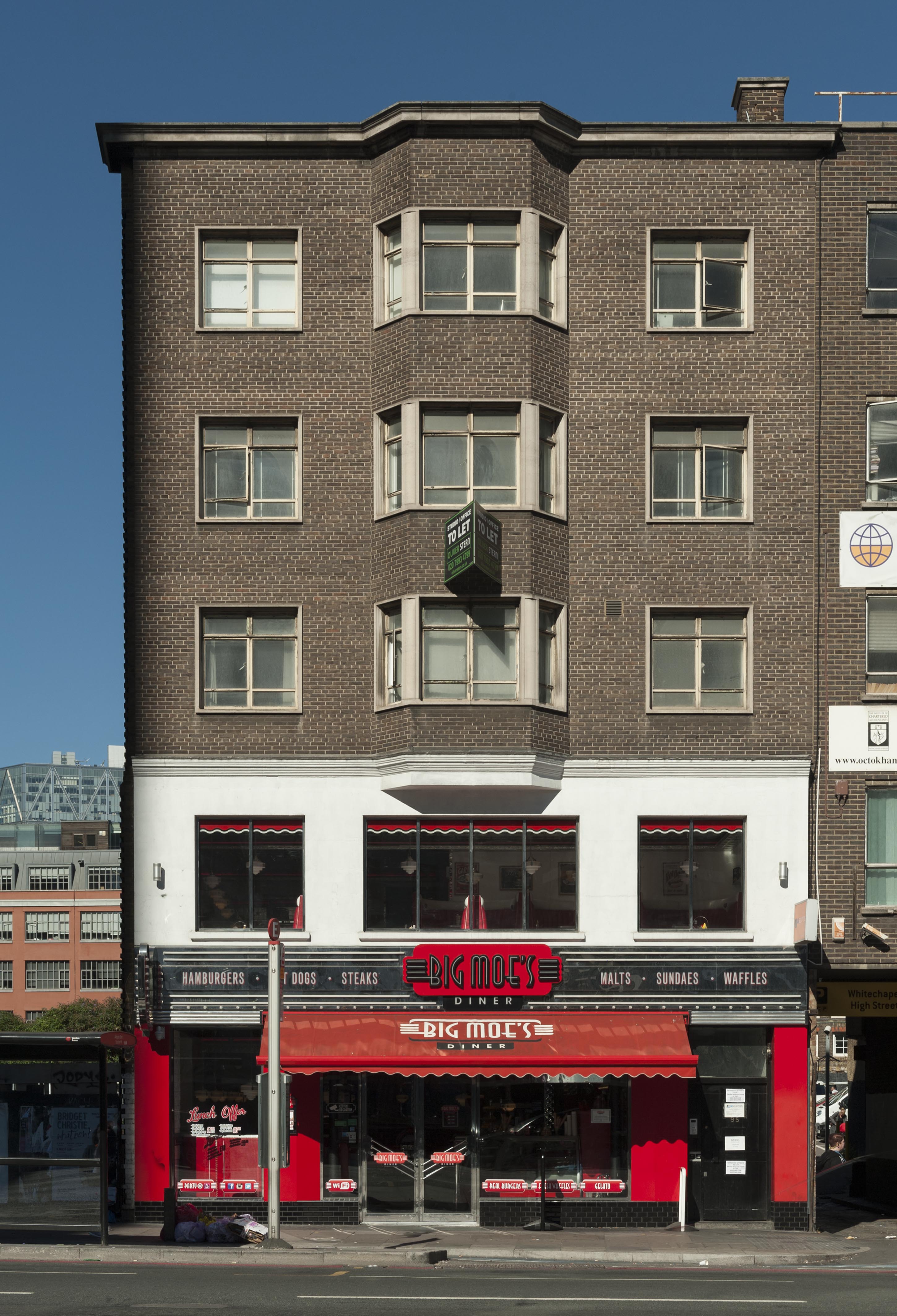
{
"id": 1198,
"title": "129-133 Whitechapel Road in early 2018",
"author": {
"id": 27,
"username": "DerekKendall"
},
"feature": {
"id": 437,
"type": "Feature",
"geometry": {
"type": "MultiPolygon",
"coordinates": [
[
[
[
-0.065795294340421,
51.51786534440968
],
[
-0.065746488420915,
51.517884201539125
],
[
-0.065653063212912,
51.517780108099075
],
[
-0.065725498229974,
51.51775563906246
],
[
-0.065813903711342,
51.517858154302715
],
[
-0.065795294340421,
51.51786534440968
]
]
]
]
},
"properties": {
"b_number": "133",
"b_name": "",
"street": "Whitechapel Road",
"address": "Bar Indo (formerly the Blue Anchor Public House), 133 Whitechapel Road",
"feature_type": "WHITECHAPEL_BUILDING",
"count": 10,
"search_str": "Bar Indo (formerly the Blue Anchor Public House), 133 Whitechapel Road"
},
"tags": []
},
"file": "https://surveyoflondon.org/media/uploads/features/437/SoL%20Whitechapel%20101842.jpg",
"description": "",
"copyright": true,
"created": "2018-03-05"
},
{
"id": 1063,
"title": "St Mary Matfelon from the north-west around 1910",
"author": {
"id": 2,
"username": "surveyoflondon"
},
"feature": {
"id": 296,
"type": "Feature",
"geometry": {
"type": "MultiPolygon",
"coordinates": [
[
[
[
-0.069238538289603,
51.51610506120929
],
[
-0.069007097235987,
51.5162239535272
],
[
-0.068282200256798,
51.51654369745104
],
[
-0.068157401560378,
51.51641994527148
],
[
-0.067807959279103,
51.51600137496063
],
[
-0.068541180339468,
51.515783257348254
],
[
-0.068555919008956,
51.51580580160597
],
[
-0.068713893455475,
51.515872451567986
],
[
-0.068778503699218,
51.51586114158782
],
[
-0.068817146392177,
51.515922550138725
],
[
-0.068888047037903,
51.51596428315636
],
[
-0.069016085124709,
51.515921053627785
],
[
-0.069107698271647,
51.51601562404751
],
[
-0.069243279190738,
51.515974904669626
],
[
-0.069238538289603,
51.51610506120929
]
]
]
]
},
"properties": {
"b_number": "",
"b_name": "Altab Ali Park, including the site of the parish church of St Mary Matfelon",
"street": "Whitechapel Road",
"address": "Altab Ali Park",
"feature_type": "OPEN_SPACE",
"count": 32,
"search_str": "Altab Ali Park, including the site of the parish church of St Mary Matfelon"
},
"tags": []
},
"file": "https://surveyoflondon.org/media/uploads/features/296/St%20Mary%20Matfelon%20postcard.jpg",
"description": "",
"copyright": false,
"created": "2018-01-19"
},
{
"id": 1168,
"title": "4-8 Davenant Street, April 2017",
"author": {
"id": 27,
"username": "DerekKendall"
},
"feature": {
"id": 444,
"type": "Feature",
"geometry": {
"type": "MultiPolygon",
"coordinates": [
[
[
[
-0.065992155100794,
51.51830166921137
],
[
-0.065887098962721,
51.51835337791054
],
[
-0.065789221022939,
51.51826327188508
],
[
-0.065599547334165,
51.51834996604178
],
[
-0.065488815177326,
51.51824884632271
],
[
-0.065919478440025,
51.518071434055805
],
[
-0.066056525174001,
51.51818387500053
],
[
-0.066044775545206,
51.51818993383309
],
[
-0.066062990401533,
51.518205353133325
],
[
-0.065946955903848,
51.51825634514006
],
[
-0.065992155100794,
51.51830166921137
]
]
]
]
},
"properties": {
"b_number": "7-8",
"b_name": "",
"street": "Davenant Street",
"address": "7-8 Davenant Street",
"feature_type": "WHITECHAPEL_BUILDING",
"count": 2,
"search_str": "7-8 Davenant Street"
},
"tags": []
},
"file": "https://surveyoflondon.org/media/uploads/features/444/SoL%20Whitechapel%20100779.jpg",
"description": "",
"copyright": true,
"created": "2018-03-05"
},
{
"id": 409,
"title": "Goulston Street",
"author": {
"id": 56,
"username": "tamara"
},
"feature": {
"id": 1742,
"type": "Feature",
"geometry": {
"type": "MultiPolygon",
"coordinates": [
[
[
[
-0.076387722492951,
51.516257872286374
],
[
-0.07580974439088,
51.51649846859169
],
[
-0.075744693982384,
51.51651411423466
],
[
-0.075332716624042,
51.51665341173461
],
[
-0.075277819023276,
51.516667372076085
],
[
-0.074429584483841,
51.51681699796736
],
[
-0.074402209988697,
51.516763242480046
],
[
-0.075229889371391,
51.51661092868018
],
[
-0.074836715281391,
51.516135055700595
],
[
-0.074917049606191,
51.51611135328064
],
[
-0.075312012611936,
51.51658616747119
],
[
-0.075695505281233,
51.51646463519818
],
[
-0.075779072585588,
51.51644696856364
],
[
-0.076328753388395,
51.516209038390684
],
[
-0.076387722492951,
51.516257872286374
]
]
]
]
},
"properties": {
"b_number": "",
"b_name": "",
"street": "",
"address": "Petticoat Lane Market",
"feature_type": "PLACE",
"count": 39,
"search_str": "Petticoat Lane Market"
},
"tags": []
},
"file": "https://surveyoflondon.org/media/uploads/features/1742/tstoll02.jpg",
"description": "Documenting the streets of Petticoat Lane market, image taken in 2016. A view in Goulston street looking north across Wentworth Street to Bell Lane, Spitalfields",
"copyright": false,
"created": "2016-09-25"
},
{
"id": 439,
"title": "1860s Dock Street frontage of the Sailors' Home, c. 1905",
"author": {
"id": 25,
"username": "Aileen"
},
"feature": {
"id": 1385,
"type": "Feature",
"geometry": {
"type": "MultiPolygon",
"coordinates": [
[
[
[
-0.067575803709333,
51.51021492278667
],
[
-0.067783647338447,
51.51017527172947
],
[
-0.067828706900756,
51.510167293395675
],
[
-0.067884358000762,
51.51028332470727
],
[
-0.068021222270461,
51.51026117174896
],
[
-0.068027105232624,
51.51027869995762
],
[
-0.068059007104689,
51.51027341168682
],
[
-0.068045803249401,
51.51025517119752
],
[
-0.068185711037114,
51.51022956959143
],
[
-0.068302205657116,
51.51049311218949
],
[
-0.068154065018083,
51.51051508999573
],
[
-0.068142111677326,
51.51048931210634
],
[
-0.068158013519995,
51.51048782991857
],
[
-0.0680993992664,
51.51035372697415
],
[
-0.068063773094401,
51.51035895389879
],
[
-0.068055396596396,
51.510336723241444
],
[
-0.067963562571312,
51.510349163498944
],
[
-0.067961653646245,
51.510339150568754
],
[
-0.067909585576321,
51.510347692789416
],
[
-0.067933270683552,
51.5104044774377
],
[
-0.067674158297256,
51.51045078856997
],
[
-0.067629160671485,
51.51036923447038
],
[
-0.067652633918951,
51.51036497018876
],
[
-0.067575803709333,
51.51021492278667
]
]
]
]
},
"properties": {
"b_number": "7",
"b_name": "",
"street": "Dock Street",
"address": "Wombat's City Hostel, 7 Dock Street",
"feature_type": "WHITECHAPEL_BUILDING",
"count": 25,
"search_str": "Wombat's City Hostel, 7 Dock Street"
},
"tags": []
},
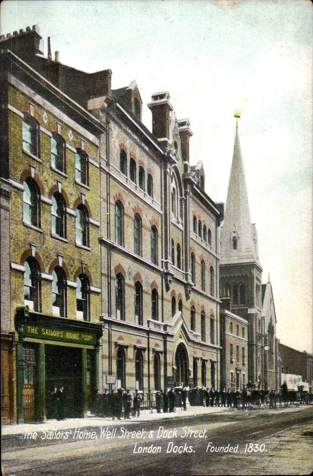
"file": "https://surveyoflondon.org/media/uploads/features/1385/eBay%20postcard%20bought%201%20Nov%202016.jpg",
"description": "A coloured postcard of the east side of Dock Street, c. 1905, showing the portion of the Sailors' Home built in 1863-5, which extended the building to Dock Street",
"copyright": false,
"created": "2016-11-03"
},
{
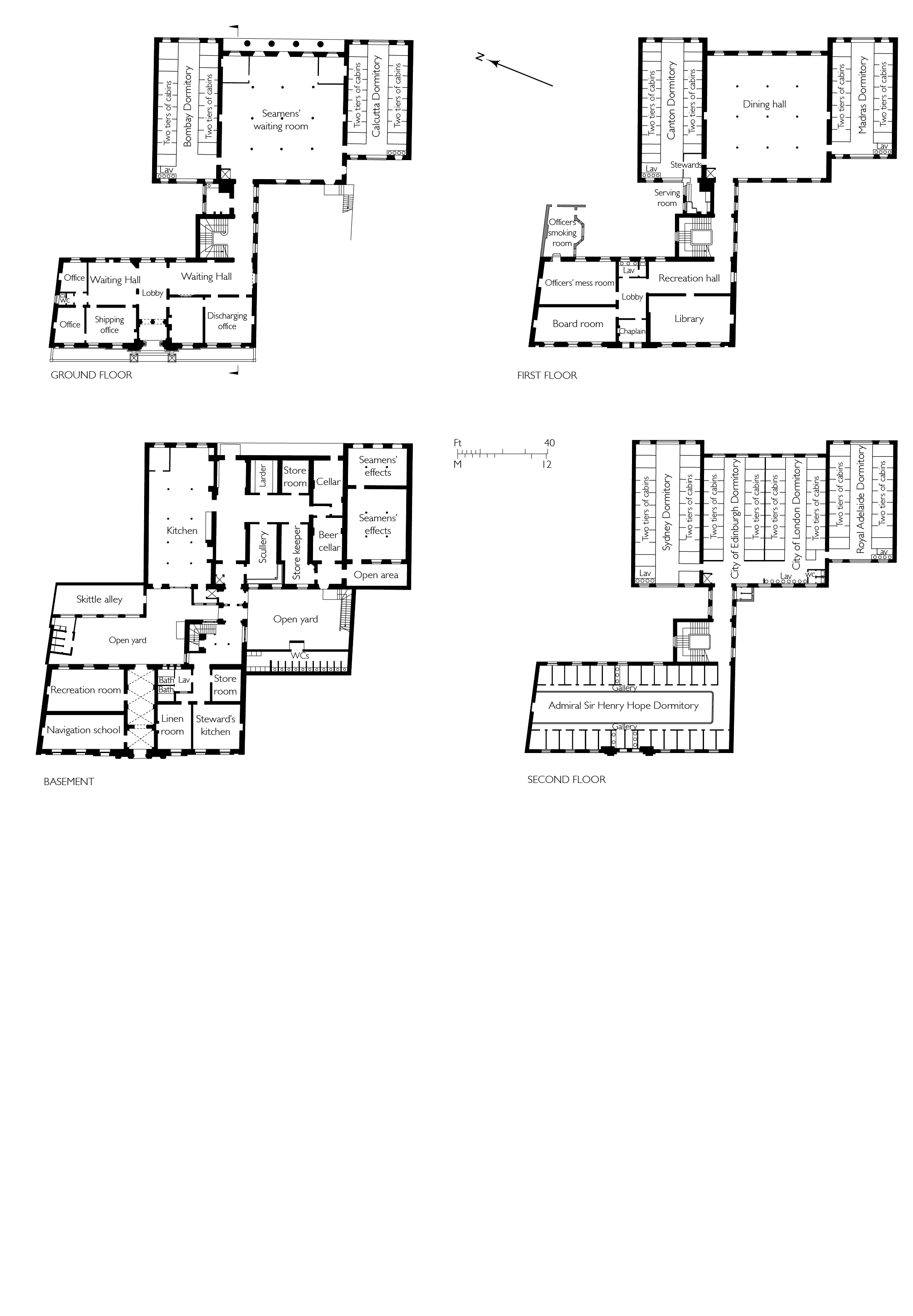
"id": 1639,
"title": "The Sailors' Home, plans in 1865",
"author": {
"id": 82,
"username": "HelenJones"
},
"feature": {
"id": 1385,
"type": "Feature",
"geometry": {
"type": "MultiPolygon",
"coordinates": [
[
[
[
-0.067575803709333,
51.51021492278667
],
[
-0.067783647338447,
51.51017527172947
],
[
-0.067828706900756,
51.510167293395675
],
[
-0.067884358000762,
51.51028332470727
],
[
-0.068021222270461,
51.51026117174896
],
[
-0.068027105232624,
51.51027869995762
],
[
-0.068059007104689,
51.51027341168682
],
[
-0.068045803249401,
51.51025517119752
],
[
-0.068185711037114,
51.51022956959143
],
[
-0.068302205657116,
51.51049311218949
],
[
-0.068154065018083,
51.51051508999573
],
[
-0.068142111677326,
51.51048931210634
],
[
-0.068158013519995,
51.51048782991857
],
[
-0.0680993992664,
51.51035372697415
],
[
-0.068063773094401,
51.51035895389879
],
[
-0.068055396596396,
51.510336723241444
],
[
-0.067963562571312,
51.510349163498944
],
[
-0.067961653646245,
51.510339150568754
],
[
-0.067909585576321,
51.510347692789416
],
[
-0.067933270683552,
51.5104044774377
],
[
-0.067674158297256,
51.51045078856997
],
[
-0.067629160671485,
51.51036923447038
],
[
-0.067652633918951,
51.51036497018876
],
[
-0.067575803709333,
51.51021492278667
]
]
]
]
},
"properties": {
"b_number": "7",
"b_name": "",
"street": "Dock Street",
"address": "Wombat's City Hostel, 7 Dock Street",
"feature_type": "WHITECHAPEL_BUILDING",
"count": 25,
"search_str": "Wombat's City Hostel, 7 Dock Street"
},
"tags": []
},
"file": "https://surveyoflondon.org/media/uploads/features/1385/Sailors%20Home%20all%20floors_Ee5uM0Q.jpg",
"description": "",
"copyright": true,
"created": "2019-08-06"
}
]
}