HTTP 200 OK
Allow: GET, HEAD, OPTIONS
Content-Type: application/json
Vary: Accept
{
"count": 1747,
"next": "https://surveyoflondon.org/api/v1/images/?format=api&page=49",
"previous": "https://surveyoflondon.org/api/v1/images/?format=api&page=47",
"results": [
{
"id": 1066,
"title": "Davenant Centre ",
"author": {
"id": 18,
"username": "shahedsaleem"
},
"feature": {
"id": 452,
"type": "Feature",
"geometry": {
"type": "MultiPolygon",
"coordinates": [
[
[
[
-0.06408176276412,
51.518388594133064
],
[
-0.064079076989357,
51.518451921601226
],
[
-0.064014118536147,
51.518467104995885
],
[
-0.063936244085074,
51.51842608315136
],
[
-0.06387175509906,
51.51844488660313
],
[
-0.063789009522268,
51.51833442643744
],
[
-0.063997611137361,
51.51827758805008
],
[
-0.06408176276412,
51.518388594133064
]
]
]
]
},
"properties": {
"b_number": "179",
"b_name": "Davenant Youth Centre (former Davenant School)",
"street": "Whitechapel Road",
"address": "Davenant Youth Centre, 179 Whitechapel Road",
"feature_type": "WHITECHAPEL_BUILDING",
"count": 18,
"search_str": "Davenant Youth Centre (former Davenant School)"
},
"tags": [
"Davenant",
"school"
]
},
"file": "https://surveyoflondon.org/media/uploads/features/452/IMG_4763.jpg",
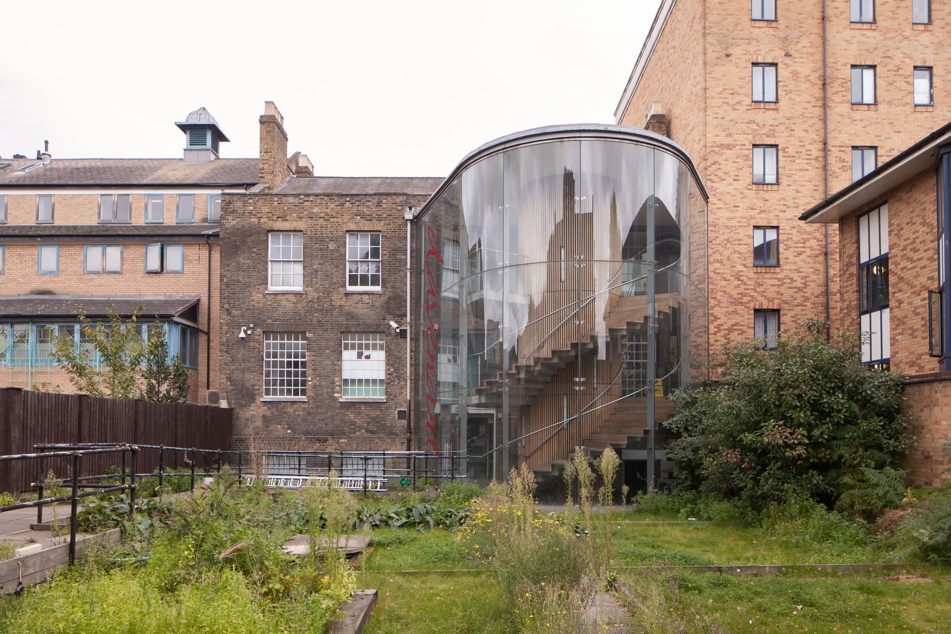
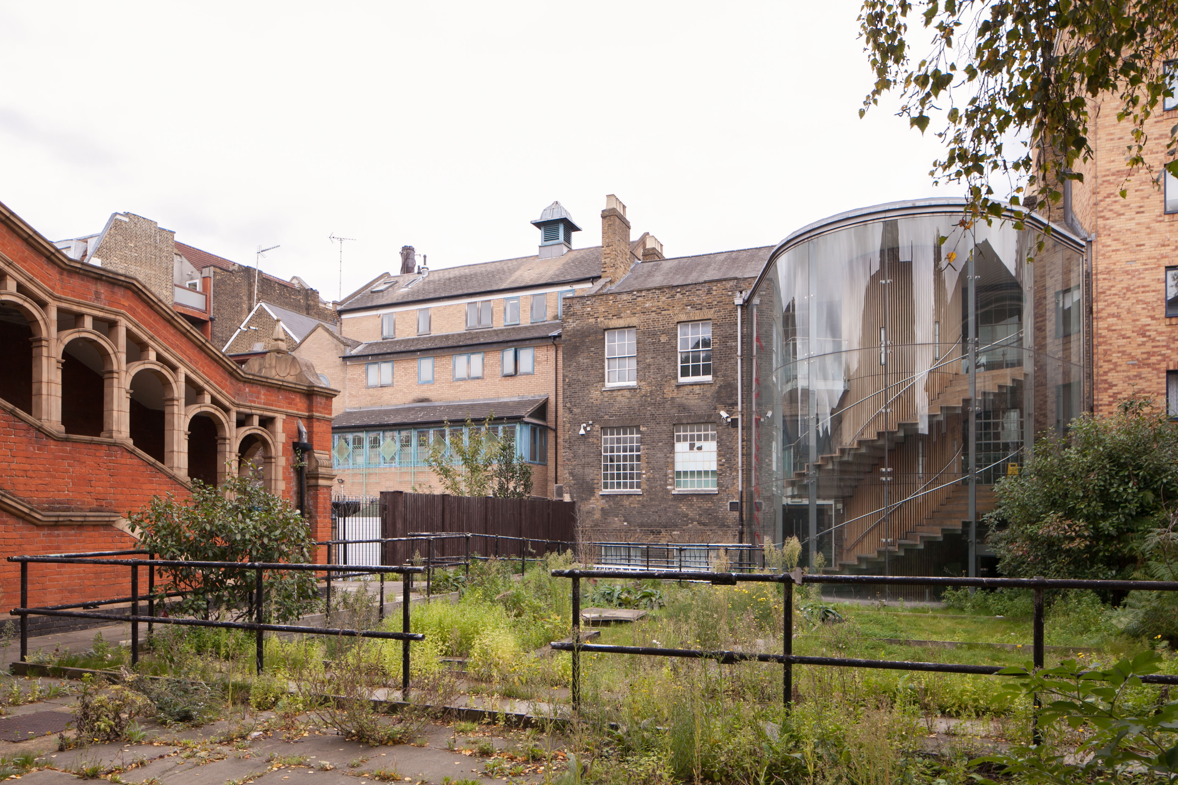
"description": "The rear of the Davenant Centre photographed in October 2017, now closed, showing the rear extension to the building",
"copyright": false,
"created": "2018-01-19"
},
{
"id": 1636,
"title": "The Chronos Building",
"author": {
"id": 286,
"username": "david3"
},
"feature": {
"id": 1604,
"type": "Feature",
"geometry": {
"type": "MultiPolygon",
"coordinates": [
[
[
[
-0.055377461177662,
51.52038715267818
],
[
-0.055361992296789,
51.52038482783517
],
[
-0.055347308734145,
51.52038098723917
],
[
-0.055337094419759,
51.5203771308233
],
[
-0.055331159361971,
51.52037433457219
],
[
-0.055308536111398,
51.52035723285001
],
[
-0.055299674716447,
51.52034530536049
],
[
-0.055294687241216,
51.52033380182095
],
[
-0.055294298256838,
51.52031248247415
],
[
-0.055342726375024,
51.520272008648945
],
[
-0.056277207331219,
51.5200864219754
],
[
-0.056291620551695,
51.520093225592746
],
[
-0.056291713275836,
51.5201925973747
],
[
-0.056224825505938,
51.520477009590564
],
[
-0.056009254616527,
51.52047865221441
],
[
-0.056057831902349,
51.52027559106523
],
[
-0.056060055905903,
51.520250448139365
],
[
-0.055517427684228,
51.52036348434812
],
[
-0.055502692893615,
51.520337160964644
],
[
-0.055455137258377,
51.52036730762135
],
[
-0.055377461177662,
51.52038715267818
]
]
]
]
},
"properties": {
"b_number": null,
"b_name": null,
"street": null,
"address": "Greater Whitechapel",
"feature_type": "GREATER_WHITECHAPEL",
"count": 2,
"search_str": "Greater Whitechapel"
},
"tags": []
},
"file": "https://surveyoflondon.org/media/uploads/features/1604/07.jpg",
"description": "",
"copyright": true,
"created": "2019-07-18"
},
{
"id": 1069,
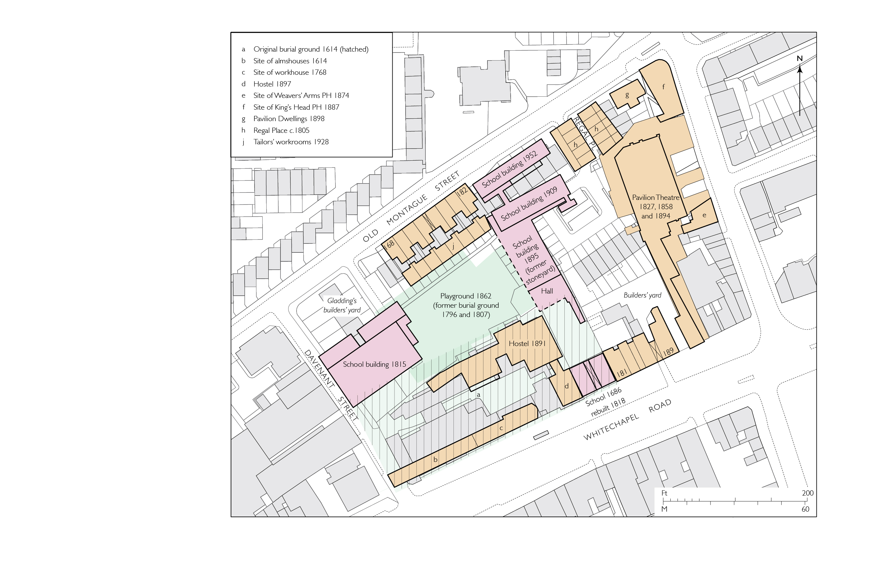
"title": "Block plan showing Davenant School buildings and principal nearby sites as in 1953 (buildings of 2016 in grey)",
"author": {
"id": 82,
"username": "HelenJones"
},
"feature": {
"id": 452,
"type": "Feature",
"geometry": {
"type": "MultiPolygon",
"coordinates": [
[
[
[
-0.06408176276412,
51.518388594133064
],
[
-0.064079076989357,
51.518451921601226
],
[
-0.064014118536147,
51.518467104995885
],
[
-0.063936244085074,
51.51842608315136
],
[
-0.06387175509906,
51.51844488660313
],
[
-0.063789009522268,
51.51833442643744
],
[
-0.063997611137361,
51.51827758805008
],
[
-0.06408176276412,
51.518388594133064
]
]
]
]
},
"properties": {
"b_number": "179",
"b_name": "Davenant Youth Centre (former Davenant School)",
"street": "Whitechapel Road",
"address": "Davenant Youth Centre, 179 Whitechapel Road",
"feature_type": "WHITECHAPEL_BUILDING",
"count": 18,
"search_str": "Davenant Youth Centre (former Davenant School)"
},
"tags": [
"Davenant",
"school"
]
},
"file": "https://surveyoflondon.org/media/uploads/features/452/Davenant%20School%20block%20plan%20final.jpg",
"description": "",
"copyright": true,
"created": "2018-01-22"
},
{
"id": 1422,
"title": "Former Church House from the southwest in October 2018",
"author": {
"id": 27,
"username": "DerekKendall"
},
"feature": {
"id": 1398,
"type": "Feature",
"geometry": {
"type": "MultiPolygon",
"coordinates": [
[
[
[
-0.06617795318375,
51.51038731673777
],
[
-0.065912350489888,
51.51041084290673
],
[
-0.06588610031897,
51.51032669039412
],
[
-0.066162776826975,
51.51030567245064
],
[
-0.06617795318375,
51.51038731673777
]
]
]
]
},
"properties": {
"b_number": "",
"b_name": "St Paul's School Mission Room and Infant Nursery (later used as Church House)",
"street": "Wellclose Square",
"address": "St Paul's School Mission Room and Infant Nursery",
"feature_type": "WHITECHAPEL_BUILDING",
"count": 11,
"search_str": "St Paul's School Mission Room and Infant Nursery (later used as Church House)"
},
"tags": []
},
"file": "https://surveyoflondon.org/media/uploads/features/1398/SoL%20Whitechapel%20102303.jpg",
"description": "",
"copyright": true,
"created": "2018-11-13"
},
{
"id": 1320,
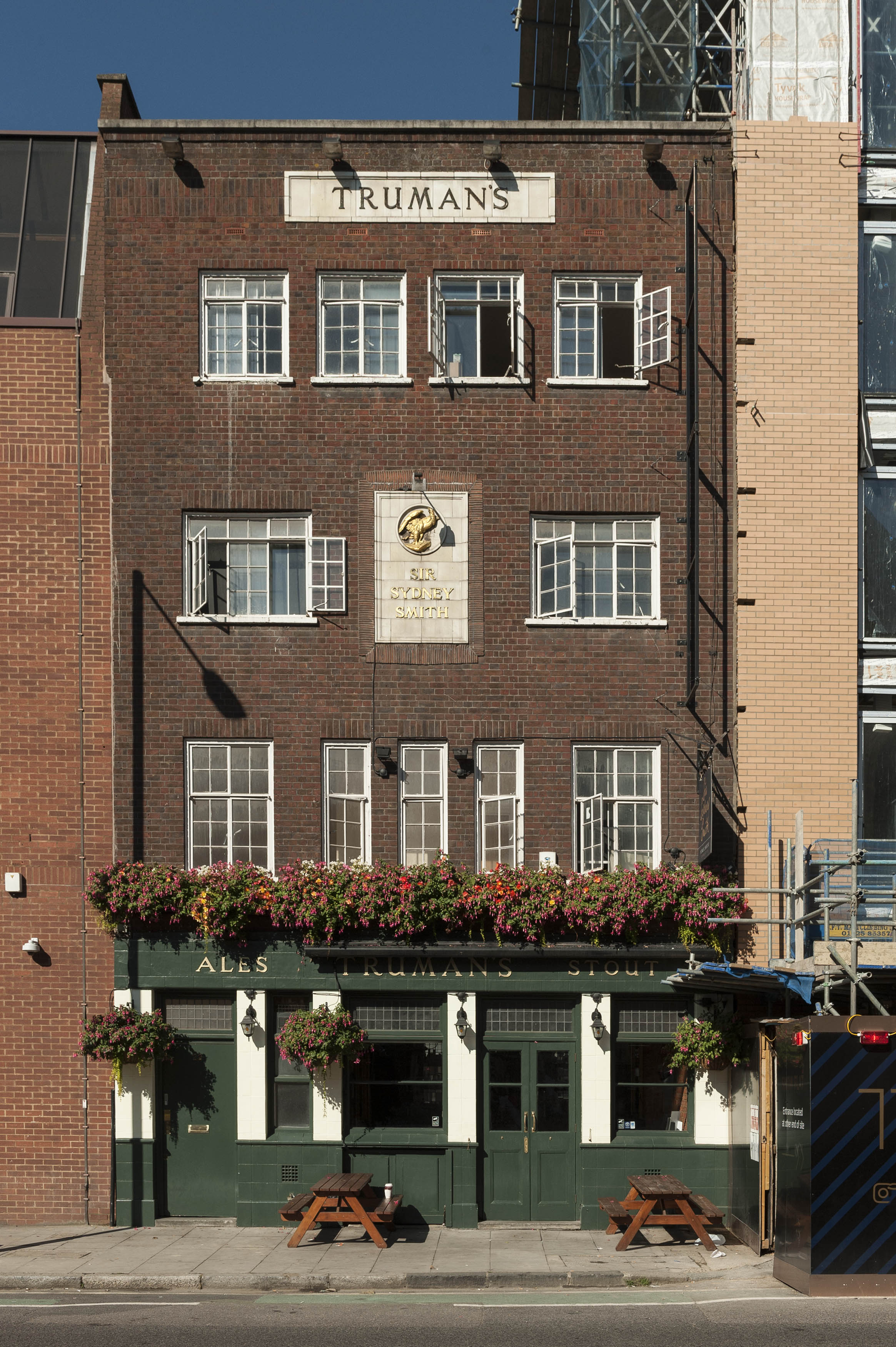
"title": "Sir Sydney Smith public house, Dock Street, in 2018",
"author": {
"id": 27,
"username": "DerekKendall"
},
"feature": {
"id": 1360,
"type": "Feature",
"geometry": {
"type": "MultiPolygon",
"coordinates": [
[
[
[
-0.068261004317242,
51.50986482765787
],
[
-0.068527831543952,
51.50981224707683
],
[
-0.068557665899307,
51.50987785366967
],
[
-0.068290030160317,
51.50992751407318
],
[
-0.068261004317242,
51.50986482765787
]
]
]
]
},
"properties": {
"b_number": "22",
"b_name": "",
"street": "Dock Street",
"address": "Sir Sidney Smith public house, 22 Dock Street",
"feature_type": "WHITECHAPEL_BUILDING",
"count": 2,
"search_str": "Sir Sidney Smith public house, 22 Dock Street"
},
"tags": []
},
"file": "https://surveyoflondon.org/media/uploads/features/1360/SoL%20Whitechapel%20102074.jpg",
"description": "",
"copyright": true,
"created": "2018-08-13"
},
{
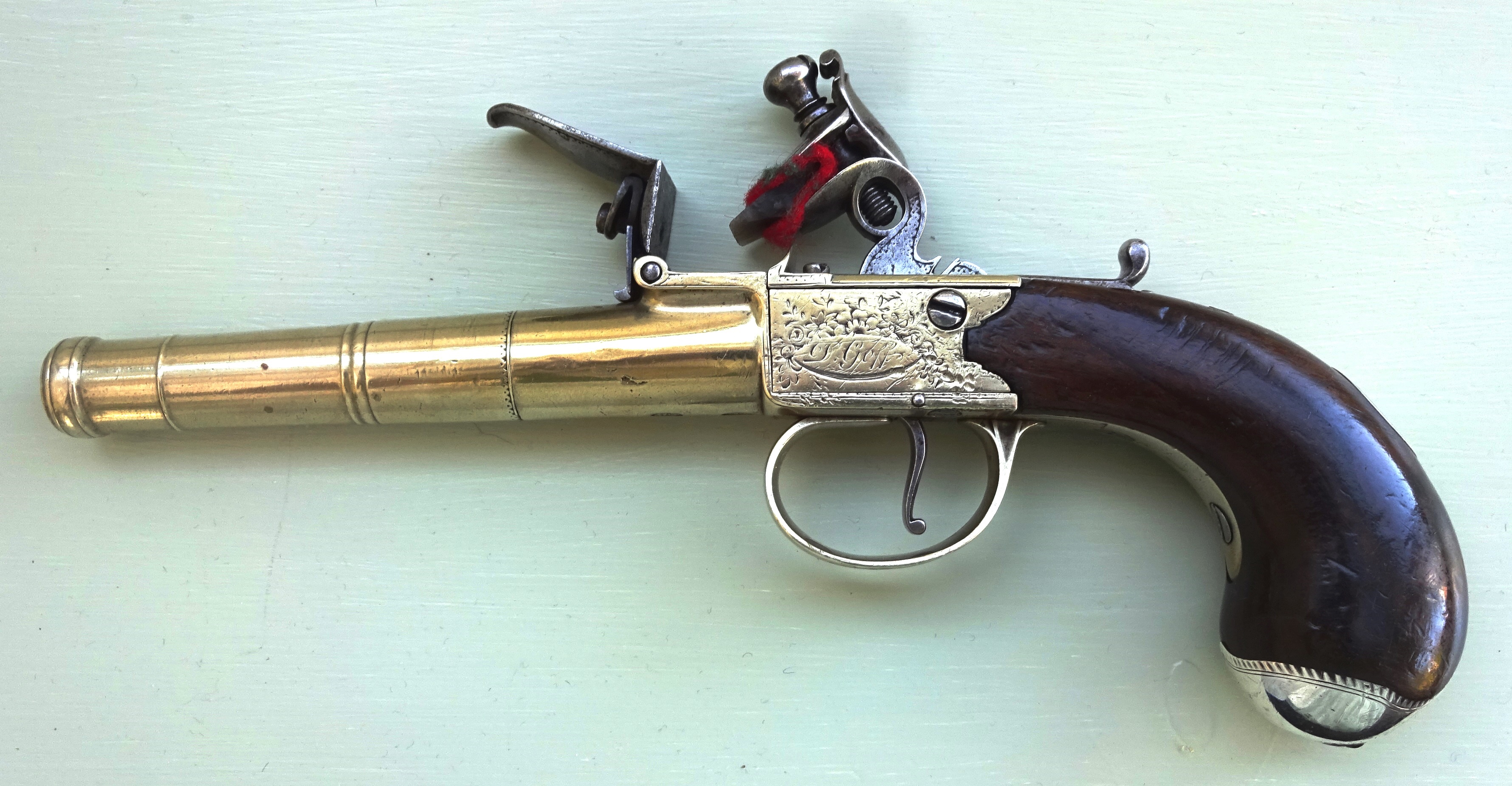
"id": 1449,
"title": "Daniel Goff pistol",
"author": {
"id": 273,
"username": "Trevor_Whitby"
},
"feature": {
"id": 12,
"type": "Feature",
"geometry": {
"type": "MultiPolygon",
"coordinates": [
[
[
[
-0.072771908194299,
51.51314802689543
],
[
-0.072672904111031,
51.51288088167866
],
[
-0.072663505327936,
51.51283676501901
],
[
-0.073096734322255,
51.51280382799201
],
[
-0.073135259915787,
51.513021133041846
],
[
-0.073135748495546,
51.51304041775518
],
[
-0.073133186687222,
51.51305633882312
],
[
-0.07312249137467,
51.513071143888
],
[
-0.073106431130218,
51.51308373453761
],
[
-0.073085308063707,
51.513095528404556
],
[
-0.073055322823247,
51.513103498247965
],
[
-0.072771908194299,
51.51314802689543
]
]
]
]
},
"properties": {
"b_number": "55",
"b_name": "",
"street": "Mansell Street",
"address": "55 Mansell Street",
"feature_type": "WHITECHAPEL_BUILDING",
"count": 7,
"search_str": "55 Mansell Street"
},
"tags": []
},
"file": "https://surveyoflondon.org/media/uploads/features/12/DSC06827.JPG",
"description": "Daniel Goff cannon-barrelled box lock pistol circa 1790. London Proof marks.",
"copyright": false,
"created": "2018-11-19"
},
{
"id": 1409,
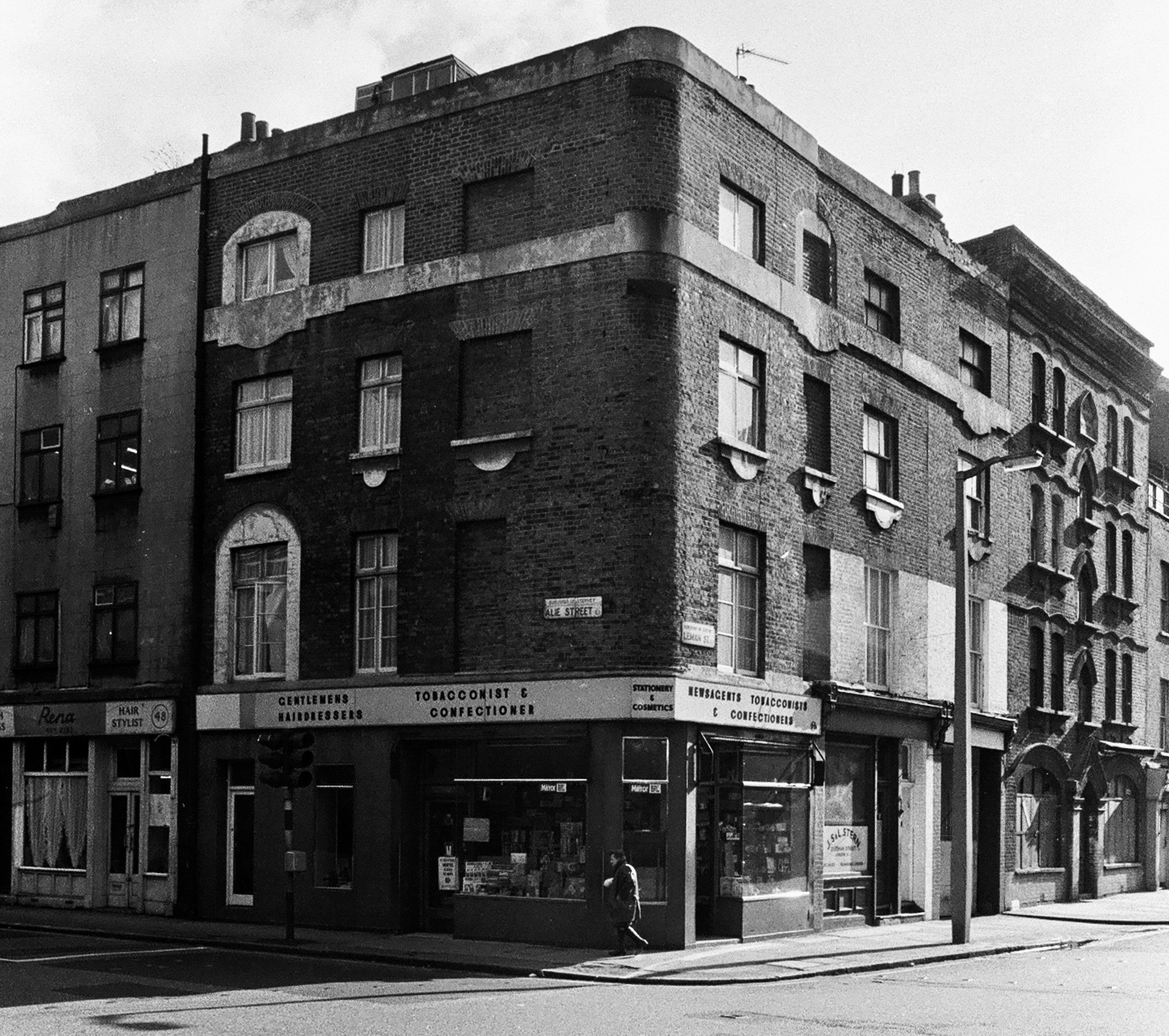
"title": "Alie Street/Leman Street southeast corner in the early 1970s (photograph by Dan Cruickshank)",
"author": {
"id": 268,
"username": "DanCruickshank"
},
"feature": {
"id": 1047,
"type": "Feature",
"geometry": {
"type": "MultiPolygon",
"coordinates": [
[
[
[
-0.070507285693422,
51.51383090440113
],
[
-0.069707737237537,
51.514184751452724
],
[
-0.069322145577777,
51.513819239326324
],
[
-0.069477910961367,
51.5137516492373
],
[
-0.069449902184866,
51.51371686688633
],
[
-0.069614131036717,
51.513655768609844
],
[
-0.069648590074739,
51.51369101943822
],
[
-0.070222944111541,
51.513488026703634
],
[
-0.070278058062727,
51.513554501477984
],
[
-0.070306902534867,
51.51354356766092
],
[
-0.070379446811545,
51.513631553258705
],
[
-0.070350540554201,
51.51364190115836
],
[
-0.070507285693422,
51.51383090440113
]
]
]
]
},
"properties": {
"b_number": "66",
"b_name": "Premier Inn, 66 Alie Street",
"street": "Alie Street",
"address": "Premier Inn, 66 Alie Street",
"feature_type": "WHITECHAPEL_BUILDING",
"count": 14,
"search_str": "Premier Inn, 66 Alie Street"
},
"tags": []
},
"file": "https://surveyoflondon.org/media/uploads/features/1047/00410001.jpg",
"description": "",
"copyright": true,
"created": "2018-11-13"
},
{
"id": 1153,
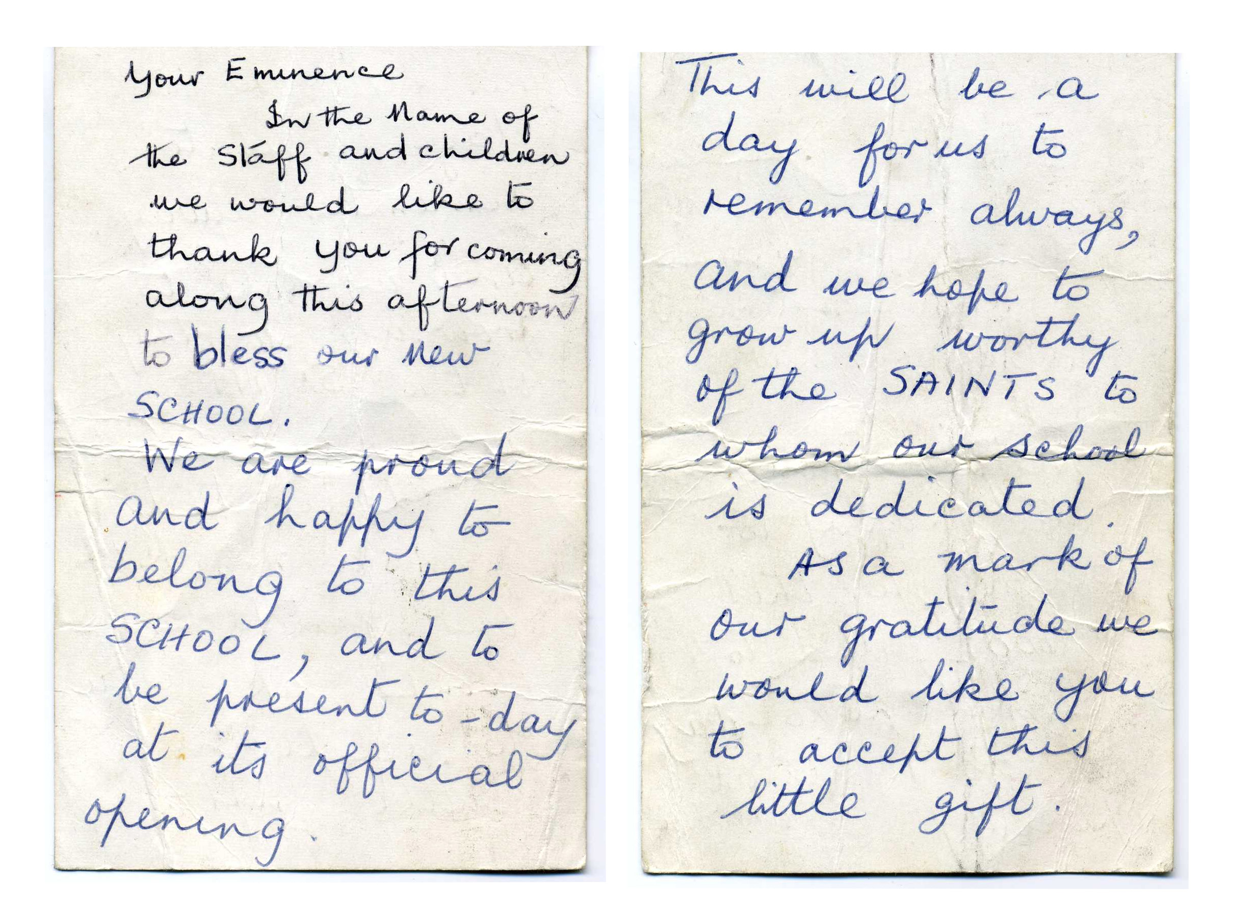
"title": "The speech by Danny McLaughlin, a pupil, to the Cardinal",
"author": {
"id": 153,
"username": "danny"
},
"feature": {
"id": 95,
"type": "Feature",
"geometry": {
"type": "MultiPolygon",
"coordinates": [
[
[
[
-0.072288312836018,
51.512824307605015
],
[
-0.072121612943253,
51.512858159153865
],
[
-0.072025478409202,
51.512890409815434
],
[
-0.072011859946938,
51.51286535896135
],
[
-0.071966433437302,
51.51287497358547
],
[
-0.071934030456307,
51.51281536880901
],
[
-0.071897041880432,
51.51282319750863
],
[
-0.071941565002123,
51.51290509717561
],
[
-0.071831416366548,
51.512942678785066
],
[
-0.071781735212569,
51.5128432447703
],
[
-0.071725521861399,
51.51285417962799
],
[
-0.07176487086724,
51.51293293466522
],
[
-0.071675647300703,
51.51295029074344
],
[
-0.071664919501195,
51.51292881954059
],
[
-0.071609406497337,
51.512939618081724
],
[
-0.071587377736956,
51.512895528347
],
[
-0.071612025842334,
51.512890733734274
],
[
-0.071602267132423,
51.512871202037054
],
[
-0.071638516898164,
51.51286415062836
],
[
-0.071631665323334,
51.51285043746628
],
[
-0.071520551906845,
51.51287205152489
],
[
-0.071479483670422,
51.51278985445861
],
[
-0.071510654926827,
51.51278379096125
],
[
-0.071493990169301,
51.51275043681792
],
[
-0.071398637684366,
51.51276898494904
],
[
-0.071377550943573,
51.51272678005531
],
[
-0.071560243982688,
51.512691242207104
],
[
-0.071533397485951,
51.51263750953841
],
[
-0.071453105482364,
51.51265312815549
],
[
-0.071420349396566,
51.51258756716799
],
[
-0.07167247628417,
51.51253852254618
],
[
-0.071707184439989,
51.512607989805105
],
[
-0.071606228537011,
51.51262762818665
],
[
-0.071633225247965,
51.51268166132723
],
[
-0.07169132093397,
51.512670360313905
],
[
-0.071712967532689,
51.512713685153294
],
[
-0.071811121682106,
51.5126945917228
],
[
-0.071768019434541,
51.512608324512954
],
[
-0.071970981647633,
51.512568842989026
],
[
-0.072017837645733,
51.51266262230734
],
[
-0.071954707384708,
51.51267490286048
],
[
-0.072013765441807,
51.5127931035959
],
[
-0.072057545202814,
51.51278458724506
],
[
-0.072087040272971,
51.512843619299026
],
[
-0.072110299177035,
51.51283569768739
],
[
-0.072067753844785,
51.51274483657161
],
[
-0.072241827775471,
51.51271310224785
],
[
-0.072288312836018,
51.512824307605015
]
]
]
]
},
"properties": {
"b_number": "",
"b_name": "",
"street": "St Mark Street",
"address": "English Martyrs RC Primary School, St Mark Street",
"feature_type": "WHITECHAPEL_BUILDING",
"count": 9,
"search_str": "English Martyrs RC Primary School, St Mark Street"
},
"tags": []
},
"file": "https://surveyoflondon.org/media/uploads/features/95/speech_m0nz3Xz.jpg",
"description": "This is the wording of the speech I had to read out to the Cardinal at the opening of the new buildings of English Martyrs School in St Mark Street in June 1970.",
"copyright": false,
"created": "2018-03-04"
},
{
"id": 1134,
"title": "Children's ward at the London Hospital, from a twentieth-century postcard",
"author": {
"id": 2,
"username": "surveyoflondon"
},
"feature": {
"id": 1230,
"type": "Feature",
"geometry": {
"type": "MultiPolygon",
"coordinates": [
[
[
[
-0.06071898744648,
51.51847914149303
],
[
-0.060743358937849,
51.518529899918775
],
[
-0.060362148562617,
51.518618013153
],
[
-0.060404024127419,
51.51868851949335
],
[
-0.060356952993906,
51.51869974522794
],
[
-0.060399234817198,
51.51877056309998
],
[
-0.060042469531136,
51.5188530372297
],
[
-0.060006551123239,
51.51879256032364
],
[
-0.05997171006068,
51.51880061452483
],
[
-0.059923949522789,
51.51872019830377
],
[
-0.059602716389847,
51.51879445706454
],
[
-0.059631951693606,
51.51884368227145
],
[
-0.059135089420495,
51.51895853862307
],
[
-0.059031394281591,
51.51878393727422
],
[
-0.059075483581288,
51.51877374555587
],
[
-0.05923306113512,
51.518737319626666
],
[
-0.059261815633844,
51.518785736083466
],
[
-0.059453095208379,
51.51874286661955
],
[
-0.059437777096903,
51.51871791341666
],
[
-0.059509844762857,
51.518701022201654
],
[
-0.059472510825189,
51.51863713193043
],
[
-0.059893693119402,
51.51853565124978
],
[
-0.059897251108141,
51.51854177905041
],
[
-0.060406197614306,
51.5184267554985
],
[
-0.060388475186227,
51.51839623334771
],
[
-0.060226549751936,
51.51811735804654
],
[
-0.060490662909997,
51.51805857683586
],
[
-0.060500593175314,
51.518078725457706
],
[
-0.06071898744648,
51.51847914149303
]
]
]
]
},
"properties": {
"b_number": "",
"b_name": "Former Royal London Hospital",
"street": "",
"address": "Former Royal London Hospital ",
"feature_type": "WHITECHAPEL_BUILDING",
"count": 53,
"search_str": "Former Royal London Hospital"
},
"tags": []
},
"file": "https://surveyoflondon.org/media/uploads/features/1230/Children's%20ward005%20300dpi.jpg",
"description": "",
"copyright": false,
"created": "2018-02-14"
},
{
"id": 1136,
"title": "Operating theatre in the London Hospital, from a 1918 postcard",
"author": {
"id": 2,
"username": "surveyoflondon"
},
"feature": {
"id": 1230,
"type": "Feature",
"geometry": {
"type": "MultiPolygon",
"coordinates": [
[
[
[
-0.06071898744648,
51.51847914149303
],
[
-0.060743358937849,
51.518529899918775
],
[
-0.060362148562617,
51.518618013153
],
[
-0.060404024127419,
51.51868851949335
],
[
-0.060356952993906,
51.51869974522794
],
[
-0.060399234817198,
51.51877056309998
],
[
-0.060042469531136,
51.5188530372297
],
[
-0.060006551123239,
51.51879256032364
],
[
-0.05997171006068,
51.51880061452483
],
[
-0.059923949522789,
51.51872019830377
],
[
-0.059602716389847,
51.51879445706454
],
[
-0.059631951693606,
51.51884368227145
],
[
-0.059135089420495,
51.51895853862307
],
[
-0.059031394281591,
51.51878393727422
],
[
-0.059075483581288,
51.51877374555587
],
[
-0.05923306113512,
51.518737319626666
],
[
-0.059261815633844,
51.518785736083466
],
[
-0.059453095208379,
51.51874286661955
],
[
-0.059437777096903,
51.51871791341666
],
[
-0.059509844762857,
51.518701022201654
],
[
-0.059472510825189,
51.51863713193043
],
[
-0.059893693119402,
51.51853565124978
],
[
-0.059897251108141,
51.51854177905041
],
[
-0.060406197614306,
51.5184267554985
],
[
-0.060388475186227,
51.51839623334771
],
[
-0.060226549751936,
51.51811735804654
],
[
-0.060490662909997,
51.51805857683586
],
[
-0.060500593175314,
51.518078725457706
],
[
-0.06071898744648,
51.51847914149303
]
]
]
]
},
"properties": {
"b_number": "",
"b_name": "Former Royal London Hospital",
"street": "",
"address": "Former Royal London Hospital ",
"feature_type": "WHITECHAPEL_BUILDING",
"count": 53,
"search_str": "Former Royal London Hospital"
},
"tags": []
},
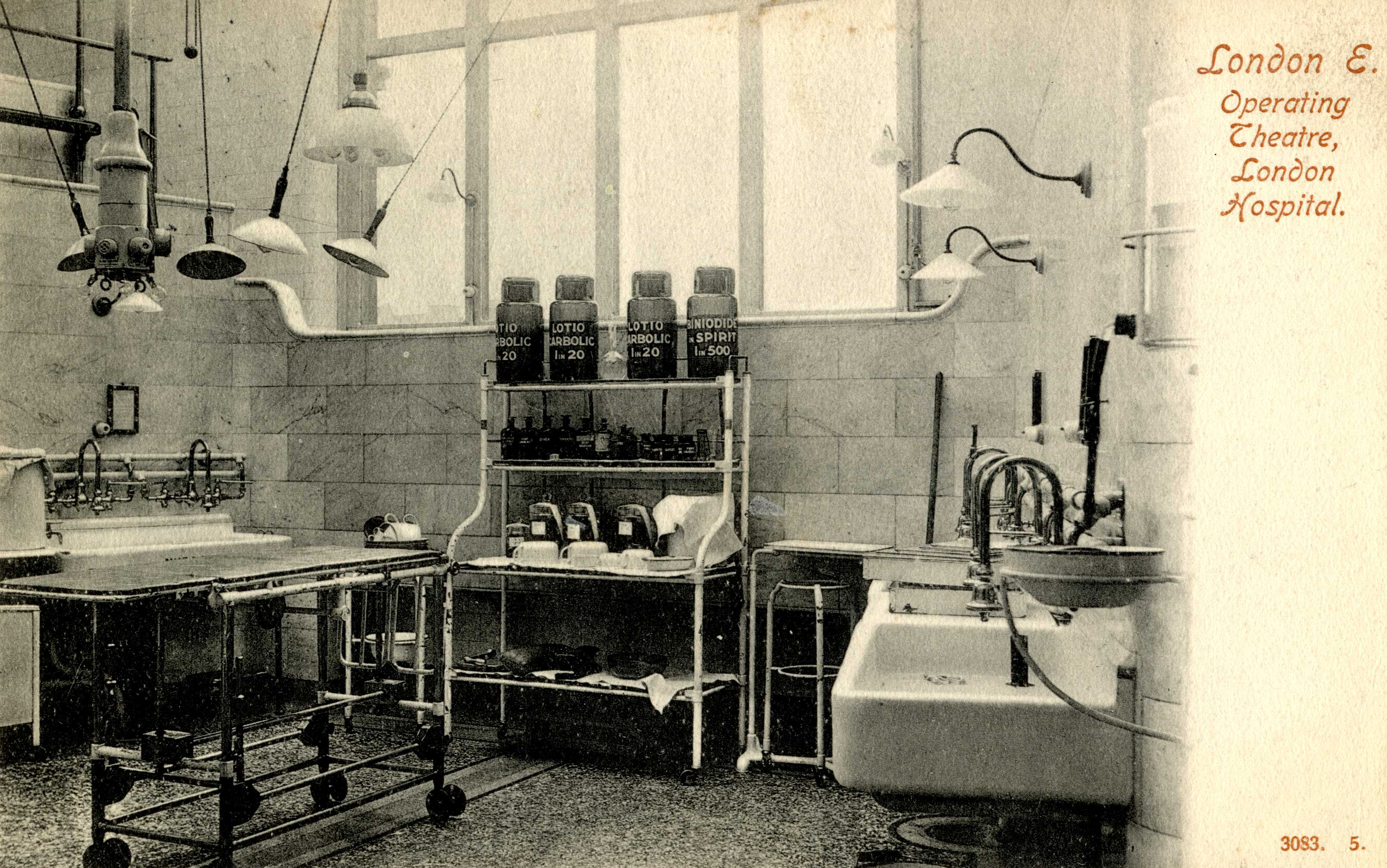
"file": "https://surveyoflondon.org/media/uploads/features/1230/Operating%20theatre007.jpg",
"description": "",
"copyright": false,
"created": "2018-02-14"
},
{
"id": 715,
"title": "1 Dock Street from the west in 2017",
"author": {
"id": 27,
"username": "DerekKendall"
},
"feature": {
"id": 1368,
"type": "Feature",
"geometry": {
"type": "MultiPolygon",
"coordinates": [
[
[
[
-0.068304836027203,
51.51073531158041
],
[
-0.068280626941554,
51.51066731775845
],
[
-0.068273645510051,
51.51064349252156
],
[
-0.068344140610016,
51.51063057393707
],
[
-0.068360428462064,
51.51067502754345
],
[
-0.068363636587595,
51.51068728948646
],
[
-0.068362263104961,
51.510697731803
],
[
-0.068356160539397,
51.5107098403773
],
[
-0.068349825933683,
51.51071642196578
],
[
-0.068338811399467,
51.5107235078495
],
[
-0.068328323844215,
51.5107291489489
],
[
-0.068318877871198,
51.510733223642234
],
[
-0.068304836027203,
51.51073531158041
]
]
]
]
},
"properties": {
"b_number": "1",
"b_name": "",
"street": "Dock Street",
"address": "1 Dock Street",
"feature_type": "WHITECHAPEL_BUILDING",
"count": 8,
"search_str": "1 Dock Street"
},
"tags": []
},
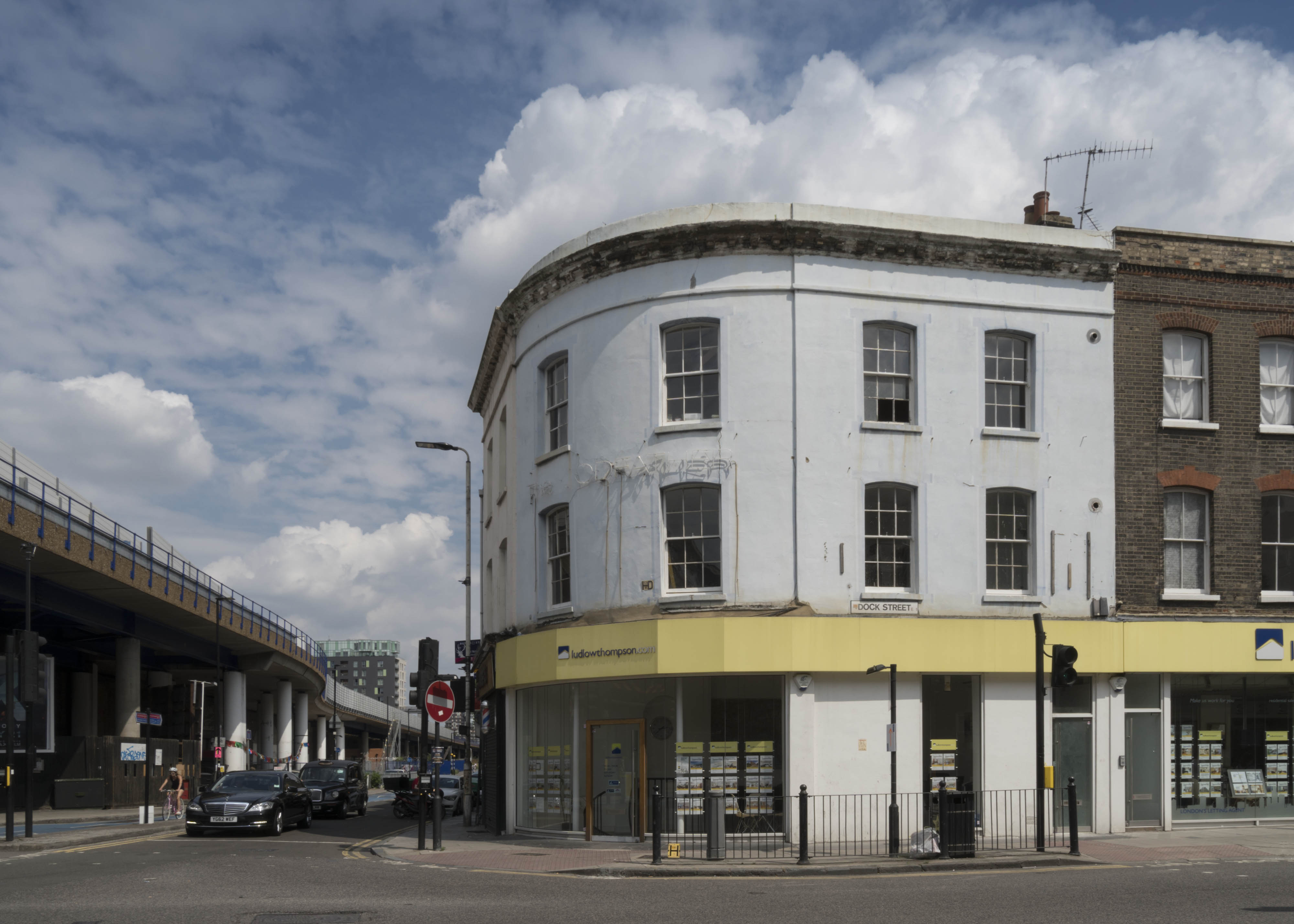
"file": "https://surveyoflondon.org/media/uploads/features/1368/SoL%20Whitechapel%20101140.jpg",
"description": "",
"copyright": true,
"created": "2017-08-02"
},
{
"id": 1318,
"title": "1 Dock Street and adjacent buildings in 2018",
"author": {
"id": 27,
"username": "DerekKendall"
},
"feature": {
"id": 1368,
"type": "Feature",
"geometry": {
"type": "MultiPolygon",
"coordinates": [
[
[
[
-0.068304836027203,
51.51073531158041
],
[
-0.068280626941554,
51.51066731775845
],
[
-0.068273645510051,
51.51064349252156
],
[
-0.068344140610016,
51.51063057393707
],
[
-0.068360428462064,
51.51067502754345
],
[
-0.068363636587595,
51.51068728948646
],
[
-0.068362263104961,
51.510697731803
],
[
-0.068356160539397,
51.5107098403773
],
[
-0.068349825933683,
51.51071642196578
],
[
-0.068338811399467,
51.5107235078495
],
[
-0.068328323844215,
51.5107291489489
],
[
-0.068318877871198,
51.510733223642234
],
[
-0.068304836027203,
51.51073531158041
]
]
]
]
},
"properties": {
"b_number": "1",
"b_name": "",
"street": "Dock Street",
"address": "1 Dock Street",
"feature_type": "WHITECHAPEL_BUILDING",
"count": 8,
"search_str": "1 Dock Street"
},
"tags": []
},
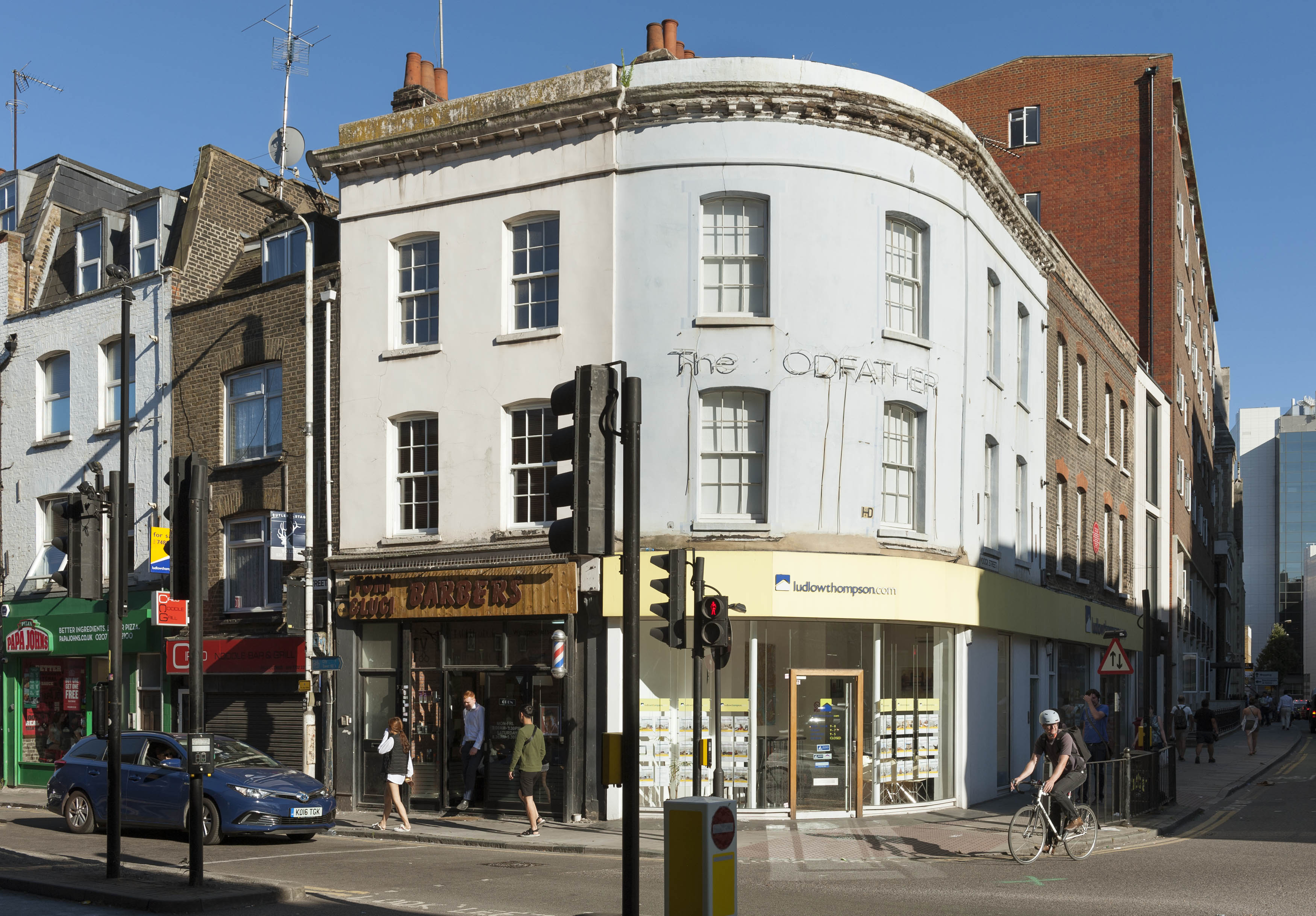
"file": "https://surveyoflondon.org/media/uploads/features/1368/SoL%20Whitechapel%20102072.jpg",
"description": "",
"copyright": true,
"created": "2018-08-13"
},
{
"id": 377,
"title": "St Paul's School, Wellclose Square, entrance detail",
"author": {
"id": 10,
"username": "PGuillery"
},
"feature": {
"id": 1399,
"type": "Feature",
"geometry": {
"type": "MultiPolygon",
"coordinates": [
[
[
[
-0.06624311370635,
51.51019072010641
],
[
-0.066077627531148,
51.510204269850675
],
[
-0.066069527116146,
51.510170337345684
],
[
-0.06611551384684,
51.51016638639934
],
[
-0.066109726117682,
51.51014703372793
],
[
-0.065814585354416,
51.5101673738921
],
[
-0.065821533323482,
51.51022330153386
],
[
-0.065683910471039,
51.51023360737856
],
[
-0.065657889334494,
51.51008339520407
],
[
-0.065349361164399,
51.51010853754948
],
[
-0.06532938777826,
51.510008209650636
],
[
-0.065633994165545,
51.509987653756085
],
[
-0.065620188745178,
51.50991765971934
],
[
-0.065722948991599,
51.50991121538507
],
[
-0.065716780377172,
51.509880881568165
],
[
-0.065901817537395,
51.50986765480321
],
[
-0.06593178354119,
51.50999605393065
],
[
-0.066038317356042,
51.509988508785376
],
[
-0.066023042932445,
51.50990918839897
],
[
-0.065998737156917,
51.50991111308007
],
[
-0.065980280001972,
51.50981894970597
],
[
-0.066320560006103,
51.50979200375635
],
[
-0.06632996113982,
51.50983401855985
],
[
-0.066268265775343,
51.50983881506029
],
[
-0.066265082872055,
51.50982597208467
],
[
-0.066214609325215,
51.509829790835916
],
[
-0.066234584593038,
51.50993011860635
],
[
-0.066179431061551,
51.509934441553284
],
[
-0.066189455574639,
51.5099837339709
],
[
-0.066197871962622,
51.509983000685985
],
[
-0.066205558541818,
51.510021498909204
],
[
-0.066199016557763,
51.510021972412325
],
[
-0.066209250254486,
51.51006632649741
],
[
-0.066216245469672,
51.51006615116071
],
[
-0.066221862792188,
51.51009851070753
],
[
-0.066214365136205,
51.51009954983773
],
[
-0.066220460291682,
51.51013162657133
],
[
-0.06623170678327,
51.51013006787535
],
[
-0.06624311370635,
51.51019072010641
]
]
]
]
},
"properties": {
"b_number": "",
"b_name": "St Paul's School",
"street": "Wellclose Square",
"address": "St Paul's School, Wellclose Square",
"feature_type": "WHITECHAPEL_BUILDING",
"count": 22,
"search_str": "St Paul's School"
},
"tags": [
"Rev. Dan Greatorex",
"Thomas F. Ford and Partners",
"Wilby & Burnett"
]
},
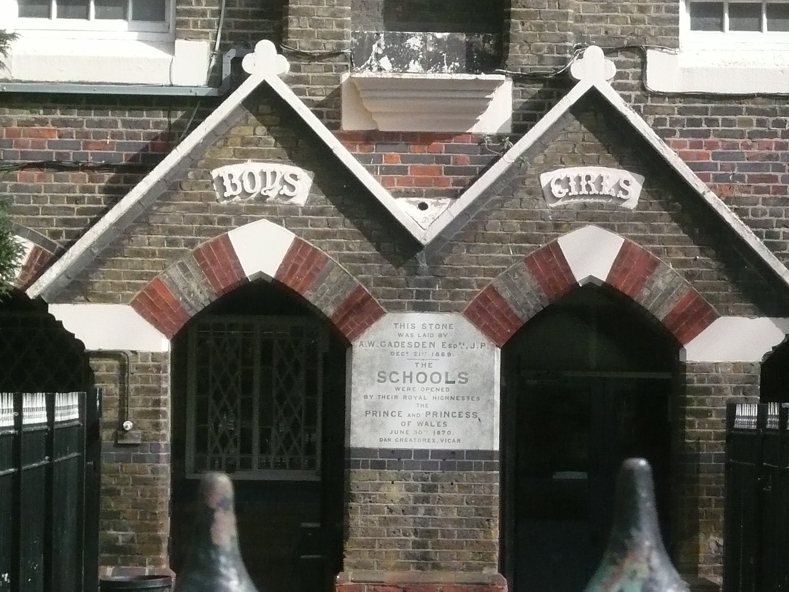
"file": "https://surveyoflondon.org/media/uploads/features/1399/P1160269.JPG",
"description": "",
"copyright": false,
"created": "2016-09-12"
},
{
"id": 1067,
"title": "Jagonari Centre",
"author": {
"id": 18,
"username": "shahedsaleem"
},
"feature": {
"id": 453,
"type": "Feature",
"geometry": {
"type": "MultiPolygon",
"coordinates": [
[
[
[
-0.06387175509906,
51.51844488660313
],
[
-0.063674757657848,
51.51849920648765
],
[
-0.063594819394982,
51.5183863647881
],
[
-0.063789009522268,
51.51833442643744
],
[
-0.06387175509906,
51.51844488660313
]
]
]
]
},
"properties": {
"b_number": "183-185",
"b_name": "Former Jagonari Women's Centre, 183-185 Whitechapel Road",
"street": "Whitechapel Road",
"address": "183-185 Whitechapel Road",
"feature_type": "WHITECHAPEL_BUILDING",
"count": 15,
"search_str": "Former Jagonari Women's Centre, 183-185 Whitechapel Road"
},
"tags": [
"GLC",
"Jagonari",
"Matrix",
"nursery"
]
},
"file": "https://surveyoflondon.org/media/uploads/features/453/IMG_4764.jpg",
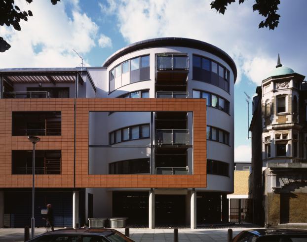
"description": "The rear of the Jagonari Centre from the back garden of the Davenant Centre, photographed in October 2017",
"copyright": false,
"created": "2018-01-19"
},
{
"id": 1040,
"title": "Poster publicising unveiling of Arch, 1989",
"author": {
"id": 212,
"username": "AnsarAhmedUllah"
},
"feature": {
"id": 296,
"type": "Feature",
"geometry": {
"type": "MultiPolygon",
"coordinates": [
[
[
[
-0.069238538289603,
51.51610506120929
],
[
-0.069007097235987,
51.5162239535272
],
[
-0.068282200256798,
51.51654369745104
],
[
-0.068157401560378,
51.51641994527148
],
[
-0.067807959279103,
51.51600137496063
],
[
-0.068541180339468,
51.515783257348254
],
[
-0.068555919008956,
51.51580580160597
],
[
-0.068713893455475,
51.515872451567986
],
[
-0.068778503699218,
51.51586114158782
],
[
-0.068817146392177,
51.515922550138725
],
[
-0.068888047037903,
51.51596428315636
],
[
-0.069016085124709,
51.515921053627785
],
[
-0.069107698271647,
51.51601562404751
],
[
-0.069243279190738,
51.515974904669626
],
[
-0.069238538289603,
51.51610506120929
]
]
]
]
},
"properties": {
"b_number": "",
"b_name": "Altab Ali Park, including the site of the parish church of St Mary Matfelon",
"street": "Whitechapel Road",
"address": "Altab Ali Park",
"feature_type": "OPEN_SPACE",
"count": 32,
"search_str": "Altab Ali Park, including the site of the parish church of St Mary Matfelon"
},
"tags": []
},
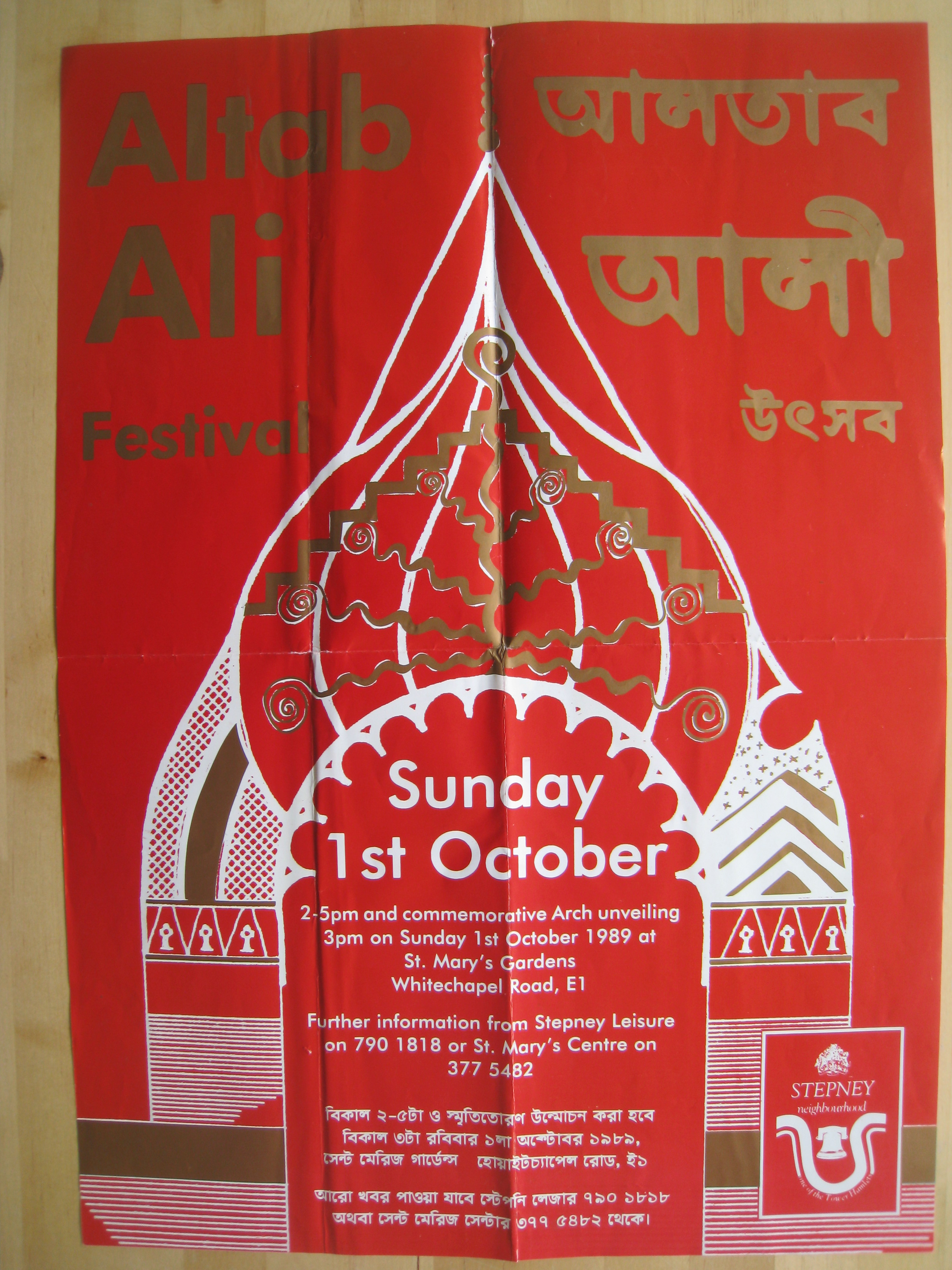
"file": "https://surveyoflondon.org/media/uploads/features/296/Altab%20Ali%20poster%20001.JPG",
"description": "",
"copyright": true,
"created": "2018-01-15"
},
{
"id": 1146,
"title": "Cardinal Heenan in procession to open the new school in St Mark Street",
"author": {
"id": 153,
"username": "danny"
},
"feature": {
"id": 95,
"type": "Feature",
"geometry": {
"type": "MultiPolygon",
"coordinates": [
[
[
[
-0.072288312836018,
51.512824307605015
],
[
-0.072121612943253,
51.512858159153865
],
[
-0.072025478409202,
51.512890409815434
],
[
-0.072011859946938,
51.51286535896135
],
[
-0.071966433437302,
51.51287497358547
],
[
-0.071934030456307,
51.51281536880901
],
[
-0.071897041880432,
51.51282319750863
],
[
-0.071941565002123,
51.51290509717561
],
[
-0.071831416366548,
51.512942678785066
],
[
-0.071781735212569,
51.5128432447703
],
[
-0.071725521861399,
51.51285417962799
],
[
-0.07176487086724,
51.51293293466522
],
[
-0.071675647300703,
51.51295029074344
],
[
-0.071664919501195,
51.51292881954059
],
[
-0.071609406497337,
51.512939618081724
],
[
-0.071587377736956,
51.512895528347
],
[
-0.071612025842334,
51.512890733734274
],
[
-0.071602267132423,
51.512871202037054
],
[
-0.071638516898164,
51.51286415062836
],
[
-0.071631665323334,
51.51285043746628
],
[
-0.071520551906845,
51.51287205152489
],
[
-0.071479483670422,
51.51278985445861
],
[
-0.071510654926827,
51.51278379096125
],
[
-0.071493990169301,
51.51275043681792
],
[
-0.071398637684366,
51.51276898494904
],
[
-0.071377550943573,
51.51272678005531
],
[
-0.071560243982688,
51.512691242207104
],
[
-0.071533397485951,
51.51263750953841
],
[
-0.071453105482364,
51.51265312815549
],
[
-0.071420349396566,
51.51258756716799
],
[
-0.07167247628417,
51.51253852254618
],
[
-0.071707184439989,
51.512607989805105
],
[
-0.071606228537011,
51.51262762818665
],
[
-0.071633225247965,
51.51268166132723
],
[
-0.07169132093397,
51.512670360313905
],
[
-0.071712967532689,
51.512713685153294
],
[
-0.071811121682106,
51.5126945917228
],
[
-0.071768019434541,
51.512608324512954
],
[
-0.071970981647633,
51.512568842989026
],
[
-0.072017837645733,
51.51266262230734
],
[
-0.071954707384708,
51.51267490286048
],
[
-0.072013765441807,
51.5127931035959
],
[
-0.072057545202814,
51.51278458724506
],
[
-0.072087040272971,
51.512843619299026
],
[
-0.072110299177035,
51.51283569768739
],
[
-0.072067753844785,
51.51274483657161
],
[
-0.072241827775471,
51.51271310224785
],
[
-0.072288312836018,
51.512824307605015
]
]
]
]
},
"properties": {
"b_number": "",
"b_name": "",
"street": "St Mark Street",
"address": "English Martyrs RC Primary School, St Mark Street",
"feature_type": "WHITECHAPEL_BUILDING",
"count": 9,
"search_str": "English Martyrs RC Primary School, St Mark Street"
},
"tags": []
},
"file": "https://surveyoflondon.org/media/uploads/features/95/Cardinal%20Heenan%20opening%20of%20English%20Martyrs%20School%201970.jpg",
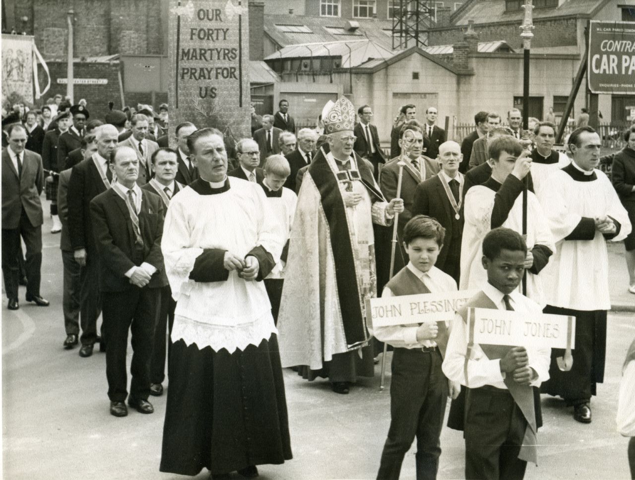
"description": "Here we see Cardinal Heenan, head of the Catholic Church in England and Wales, in procession to the opening ceremony the new English Martyrs' School in St Mark Street. This event took place on Saturday 20 June 1970. He's surrounded by men in one of the Catholic fraternities that were active at that time. The schoolboys carry placards with some of the names of the 40 English Martyrs remembered by the Church. The school had moved from its original building in Chamber Street behind the Church of the English Martyrs in Prescot Street. \n\nMy dad, John McLaughlin, can be seen in the background of the picture and as an eleven year old in that last year before going to secondary school, I was tasked with giving the welcome speech to the cardinal.",
"copyright": false,
"created": "2018-03-04"
},
{
"id": 1425,
"title": "Former Church House from the southeast in October 2018",
"author": {
"id": 27,
"username": "DerekKendall"
},
"feature": {
"id": 1398,
"type": "Feature",
"geometry": {
"type": "MultiPolygon",
"coordinates": [
[
[
[
-0.06617795318375,
51.51038731673777
],
[
-0.065912350489888,
51.51041084290673
],
[
-0.06588610031897,
51.51032669039412
],
[
-0.066162776826975,
51.51030567245064
],
[
-0.06617795318375,
51.51038731673777
]
]
]
]
},
"properties": {
"b_number": "",
"b_name": "St Paul's School Mission Room and Infant Nursery (later used as Church House)",
"street": "Wellclose Square",
"address": "St Paul's School Mission Room and Infant Nursery",
"feature_type": "WHITECHAPEL_BUILDING",
"count": 11,
"search_str": "St Paul's School Mission Room and Infant Nursery (later used as Church House)"
},
"tags": []
},
"file": "https://surveyoflondon.org/media/uploads/features/1398/SoL%20Whitechapel%20102308.jpg",
"description": "",
"copyright": true,
"created": "2018-11-13"
},
{
"id": 1426,
"title": "Former Church House from the south in October 2018",
"author": {
"id": 27,
"username": "DerekKendall"
},
"feature": {
"id": 1398,
"type": "Feature",
"geometry": {
"type": "MultiPolygon",
"coordinates": [
[
[
[
-0.06617795318375,
51.51038731673777
],
[
-0.065912350489888,
51.51041084290673
],
[
-0.06588610031897,
51.51032669039412
],
[
-0.066162776826975,
51.51030567245064
],
[
-0.06617795318375,
51.51038731673777
]
]
]
]
},
"properties": {
"b_number": "",
"b_name": "St Paul's School Mission Room and Infant Nursery (later used as Church House)",
"street": "Wellclose Square",
"address": "St Paul's School Mission Room and Infant Nursery",
"feature_type": "WHITECHAPEL_BUILDING",
"count": 11,
"search_str": "St Paul's School Mission Room and Infant Nursery (later used as Church House)"
},
"tags": []
},
"file": "https://surveyoflondon.org/media/uploads/features/1398/SoL%20Whitechapel%20102309.jpg",
"description": "",
"copyright": true,
"created": "2018-11-13"
},
{
"id": 1344,
"title": "Canon Barnett Primary School from the west in 2018",
"author": {
"id": 27,
"username": "DerekKendall"
},
"feature": {
"id": 399,
"type": "Feature",
"geometry": {
"type": "MultiPolygon",
"coordinates": [
[
[
[
-0.0718106394676,
51.51610397748269
],
[
-0.071910650694868,
51.51607255627536
],
[
-0.072009433966083,
51.51618984809891
],
[
-0.071907256843951,
51.51622171585677
],
[
-0.071907271171249,
51.51622171812537
],
[
-0.071907268076959,
51.51622171909061
],
[
-0.071931795963511,
51.5162521618839
],
[
-0.071610195810633,
51.516352649906445
],
[
-0.071600272401668,
51.516341236744296
],
[
-0.071463340884386,
51.51638740891522
],
[
-0.071422376478407,
51.516309559498886
],
[
-0.07144244173494,
51.51630248744659
],
[
-0.071392341446793,
51.516238646773026
],
[
-0.071558823959752,
51.51618439684411
],
[
-0.071567446232768,
51.516194850907375
],
[
-0.071743764744855,
51.516135543880424
],
[
-0.071736254917458,
51.516127340619526
],
[
-0.0718106394676,
51.51610397748269
]
]
]
]
},
"properties": {
"b_number": "",
"b_name": "Canon Barnett Primary School",
"street": "Gunthorpe Street",
"address": "Canon Barnett School",
"feature_type": "WHITECHAPEL_BUILDING",
"count": 6,
"search_str": "Canon Barnett Primary School"
},
"tags": []
},
"file": "https://surveyoflondon.org/media/uploads/features/399/SoL%20Whitechapel%20102193.jpg",
"description": "",
"copyright": true,
"created": "2018-10-10"
},
{
"id": 1206,
"title": "Urban Bar, 176 Whitechapel Road, interior in early 2018",
"author": {
"id": 27,
"username": "DerekKendall"
},
"feature": {
"id": 1231,
"type": "Feature",
"geometry": {
"type": "MultiPolygon",
"coordinates": [
[
[
[
-0.058999857002125,
51.518957100386174
],
[
-0.059048592228483,
51.519036675524816
],
[
-0.059042002286964,
51.5190605621672
],
[
-0.058864726926981,
51.51910678355749
],
[
-0.058822200523125,
51.51902777962813
],
[
-0.058802097602954,
51.51899416748291
],
[
-0.058712070836869,
51.51884364184363
],
[
-0.058774083983596,
51.518828793526126
],
[
-0.058821128899218,
51.51890526890926
],
[
-0.058783587749907,
51.518914257701724
],
[
-0.058783583000377,
51.51891425883895
],
[
-0.058824025690886,
51.51898280999364
],
[
-0.058823998639063,
51.518982764140226
],
[
-0.058880213224576,
51.51896985673114
],
[
-0.058889131635543,
51.518984974852245
],
[
-0.058999857002125,
51.518957100386174
]
]
]
]
},
"properties": {
"b_number": "176",
"b_name": "",
"street": "Whitechapel Road",
"address": "Former London Hospital Tavern",
"feature_type": "WHITECHAPEL_BUILDING",
"count": 5,
"search_str": "Former London Hospital Tavern"
},
"tags": []
},
"file": "https://surveyoflondon.org/media/uploads/features/1231/SoL%20Whitechapel%20101859.jpg",
"description": "",
"copyright": true,
"created": "2018-03-05"
}
]
}