HTTP 200 OK
Allow: GET, HEAD, OPTIONS
Content-Type: application/json
Vary: Accept
{
"count": 1712,
"next": "https://surveyoflondon.org/api/v1/features/?format=api&page=28",
"previous": "https://surveyoflondon.org/api/v1/features/?format=api&page=26",
"results": {
"type": "FeatureCollection",
"features": [
{
"id": 1526,
"type": "Feature",
"geometry": {
"type": "MultiPolygon",
"coordinates": [
[
[
[
-0.053468807813572,
51.52174244538152
],
[
-0.053830589450479,
51.52152363005685
],
[
-0.053927416192583,
51.52158548848943
],
[
-0.053565634513495,
51.521804304110375
],
[
-0.053468807813572,
51.52174244538152
]
]
]
]
},
"properties": {
"b_name": null,
"address": "Greater Whitechapel",
"postcode": "E1",
"street": null,
"categories": [],
"count": 0,
"current": null,
"site": null,
"feature_type": "GREATER_WHITECHAPEL",
"documents": [],
"images": [],
"media": []
}
},
{
"id": 309,
"type": "Feature",
"geometry": {
"type": "MultiPolygon",
"coordinates": [
[
[
[
-0.067342056542446,
51.51595229150235
],
[
-0.06720909350106,
51.51598612850739
],
[
-0.067215612254105,
51.51599610006675
],
[
-0.066967875862765,
51.51607077500592
],
[
-0.066943505623533,
51.516045801342486
],
[
-0.066872215104146,
51.516062640366314
],
[
-0.066687975731216,
51.51576616844689
],
[
-0.066772061905033,
51.51574797548992
],
[
-0.066781404944717,
51.51576365622977
],
[
-0.066840470527197,
51.515750501597594
],
[
-0.066864718521341,
51.51578760648666
],
[
-0.06690018672339,
51.51578087936016
],
[
-0.066976504897049,
51.51590397643649
],
[
-0.067125710374891,
51.51586801763614
],
[
-0.06716316564337,
51.5159343313778
],
[
-0.067279497626802,
51.51590497407305
],
[
-0.067285655221519,
51.5159110802806
],
[
-0.067313994004403,
51.515903740519775
],
[
-0.067329816922355,
51.51592882147948
],
[
-0.067342056542446,
51.51595229150235
]
]
]
]
},
"properties": {
"b_name": "Wynfrid House",
"address": "Wynfrid House, 20 Mulberry Street",
"postcode": "E1 1EE",
"street": "Mulberry Street",
"categories": [
{
"id": 6,
"name": "Housing",
"description": "",
"thumbnail": "https://surveyoflondon.org/media/SoL-Whitechapel100082.jpg"
},
{
"id": 1,
"name": "Immigration",
"description": "",
"thumbnail": "https://surveyoflondon.org/media/SoL-Whitechapel100371-cropped.jpg"
}
],
"count": 1,
"current": 1970,
"site": null,
"feature_type": "WHITECHAPEL_BUILDING",
"documents": [
{
"id": 113,
"title": "Wynfrid House",
"author": {
"id": 2,
"username": "surveyoflondon"
}
}
],
"images": [],
"media": []
}
},
{
"id": 1006,
"type": "Feature",
"geometry": {
"type": "MultiPolygon",
"coordinates": [
[
[
[
-0.068752847280629,
51.512750651725796
],
[
-0.068161859234581,
51.51293983834493
],
[
-0.068121133120152,
51.51279588873124
],
[
-0.068629392675914,
51.5126387251605
],
[
-0.068752847280629,
51.512750651725796
]
]
]
]
},
"properties": {
"b_name": "55–112 Times Square",
"address": "55–112 Times Square",
"postcode": "E1 8GE",
"street": "Times Square",
"categories": [
{
"id": 6,
"name": "Housing",
"description": "",
"thumbnail": "https://surveyoflondon.org/media/SoL-Whitechapel100082.jpg"
}
],
"count": 6,
"current": 2007,
"site": {
"id": 124,
"name": "Goodman's Fields"
},
"feature_type": "WHITECHAPEL_BUILDING",
"documents": [
{
"id": 1062,
"title": "Goodman’s Fields East: early development",
"author": {
"id": 2,
"username": "surveyoflondon"
}
},
{
"id": 1078,
"title": "Gower's Walk Free School",
"author": {
"id": 2,
"username": "surveyoflondon"
}
}
],
"images": [],
"media": []
}
},
{
"id": 1009,
"type": "Feature",
"geometry": {
"type": "MultiPolygon",
"coordinates": [
[
[
[
-0.068205789577836,
51.51237579356644
],
[
-0.067741456260696,
51.51244326048929
],
[
-0.067710526289184,
51.512321352717834
],
[
-0.06814668259128,
51.512244756176266
],
[
-0.068205789577836,
51.51237579356644
]
]
]
]
},
"properties": {
"b_name": "113–145 Times Square, Hooper Street",
"address": "113–145 Times Square, Hooper Street",
"postcode": "E1 8GF",
"street": "Hooper Street",
"categories": [
{
"id": 6,
"name": "Housing",
"description": "",
"thumbnail": "https://surveyoflondon.org/media/SoL-Whitechapel100082.jpg"
}
],
"count": 5,
"current": 2007,
"site": {
"id": 124,
"name": "Goodman's Fields"
},
"feature_type": "WHITECHAPEL_BUILDING",
"documents": [],
"images": [
{
"id": 1758,
"title": "Times Square from the north-west in 2017",
"author": {
"id": 27,
"username": "DerekKendall"
}
}
],
"media": []
}
},
{
"id": 1007,
"type": "Feature",
"geometry": {
"type": "MultiPolygon",
"coordinates": [
[
[
[
-0.068604481747272,
51.51259519216751
],
[
-0.068394295073252,
51.512662674029954
],
[
-0.068193731130485,
51.51223927149179
],
[
-0.068417624655329,
51.51219797913798
],
[
-0.068604481747272,
51.51259519216751
]
]
]
]
},
"properties": {
"b_name": "1–54 Times Square, Hooper Street",
"address": "1–54 Times Square",
"postcode": "E1 8GD",
"street": "Hooper Street",
"categories": [
{
"id": 6,
"name": "Housing",
"description": "",
"thumbnail": "https://surveyoflondon.org/media/SoL-Whitechapel100082.jpg"
}
],
"count": 10,
"current": 2007,
"site": {
"id": 124,
"name": "Goodman's Fields"
},
"feature_type": "WHITECHAPEL_BUILDING",
"documents": [],
"images": [
{
"id": 937,
"title": "Lambeth Street c.1980",
"author": {
"id": 201,
"username": "stephen"
}
},
{
"id": 1407,
"title": "Lambeth Street from the south in the early 1970s (photograph by Dan Cruickshank)",
"author": {
"id": 268,
"username": "DanCruickshank"
}
},
{
"id": 1761,
"title": "1–54 Times Square from the north-west in 2017",
"author": {
"id": 27,
"username": "DerekKendall"
}
},
{
"id": 1762,
"title": "Times Square from the west in 2017",
"author": {
"id": 27,
"username": "DerekKendall"
}
},
{
"id": 1763,
"title": "1–54 Times Square and Christopher Court from the south in 2017",
"author": {
"id": 27,
"username": "DerekKendall"
}
},
{
"id": 1764,
"title": "Times Square from the south-west in 2017",
"author": {
"id": 27,
"username": "DerekKendall"
}
}
],
"media": []
}
},
{
"id": 1214,
"type": "Feature",
"geometry": {
"type": "MultiPolygon",
"coordinates": [
[
[
[
-0.06113840807932,
51.51500192856946
],
[
-0.061070456267118,
51.515000805077534
],
[
-0.061079046393881,
51.5147985484324
],
[
-0.061146997909739,
51.51479967194591
],
[
-0.061143042366689,
51.51489280728168
],
[
-0.06113840807932,
51.51500192856946
]
]
]
]
},
"properties": {
"b_name": "",
"address": "171 Commercial Road",
"postcode": "E1 2JP",
"street": "Commercial Road",
"categories": [
{
"id": 4,
"name": "Commerce",
"description": "",
"thumbnail": "https://surveyoflondon.org/media/SoL-Whitechapel100156.jpg"
},
{
"id": 3,
"name": "Industry",
"description": "",
"thumbnail": "https://surveyoflondon.org/media/DP130783.jpg"
},
{
"id": 1,
"name": "Immigration",
"description": "",
"thumbnail": "https://surveyoflondon.org/media/SoL-Whitechapel100371-cropped.jpg"
}
],
"count": 2,
"current": null,
"site": null,
"feature_type": "WHITECHAPEL_BUILDING",
"documents": [
{
"id": 106,
"title": "M.A. Kutchinsky Ltd",
"author": {
"id": 25,
"username": "Aileen"
}
}
],
"images": [],
"media": [
{
"id": 11,
"title": "1957 Pathé newsreel about M.A. Kutchinsky Ltd, jewellers",
"author": {
"id": 25,
"username": "Aileen"
}
}
]
}
},
{
"id": 759,
"type": "Feature",
"geometry": {
"type": "MultiPolygon",
"coordinates": [
[
[
[
-0.065144823831124,
51.51614628532356
],
[
-0.064673979815327,
51.51618333044365
],
[
-0.064615077021909,
51.51615619958676
],
[
-0.064609390185841,
51.51612306029443
],
[
-0.064659159816088,
51.51608438512543
],
[
-0.064742496721768,
51.51607870065723
],
[
-0.064740334060872,
51.51606473633635
],
[
-0.064707670405808,
51.51603641773942
],
[
-0.064651427012241,
51.51604025413421
],
[
-0.064628207571599,
51.51590774066986
],
[
-0.064668008700048,
51.515905025813275
],
[
-0.064664544120365,
51.5158852534767
],
[
-0.065090332975764,
51.51585620931841
],
[
-0.065095163792228,
51.51588377728603
],
[
-0.065183272903108,
51.51587776693834
],
[
-0.065198469693564,
51.51596448913735
],
[
-0.065113976880081,
51.51597025279962
],
[
-0.065144823831124,
51.51614628532356
]
]
]
]
},
"properties": {
"b_name": "Kobi Nazrul Primary School",
"address": "Kobi Nazrul Primary School, Settles Street",
"postcode": "E1 1JP",
"street": "Settles Street",
"categories": [
{
"id": 10,
"name": "Education",
"description": "",
"thumbnail": "https://surveyoflondon.org/media/SoL-Whitechapel100368-cropped.jpg"
}
],
"count": 0,
"current": 1994,
"site": null,
"feature_type": "WHITECHAPEL_BUILDING",
"documents": [],
"images": [],
"media": []
}
},
{
"id": 810,
"type": "Feature",
"geometry": {
"type": "MultiPolygon",
"coordinates": [
[
[
[
-0.062561206989557,
51.51712596840826
],
[
-0.062703897825537,
51.517109177946516
],
[
-0.062707938523893,
51.517126433069386
],
[
-0.062763582691929,
51.517121360840505
],
[
-0.062768293263644,
51.51714973575227
],
[
-0.062703248829325,
51.51715911797964
],
[
-0.062574654996313,
51.51717342751021
],
[
-0.062561206989557,
51.51712596840826
]
]
]
]
},
"properties": {
"b_name": "",
"address": "95 New Road",
"postcode": "E1 1HL",
"street": "New Road",
"categories": [
{
"id": 6,
"name": "Housing",
"description": "",
"thumbnail": "https://surveyoflondon.org/media/SoL-Whitechapel100082.jpg"
},
{
"id": 4,
"name": "Commerce",
"description": "",
"thumbnail": "https://surveyoflondon.org/media/SoL-Whitechapel100156.jpg"
},
{
"id": 5,
"name": "Restaurants",
"description": "",
"thumbnail": "https://surveyoflondon.org/media/SoL_Whitechapel100308.jpg"
}
],
"count": 1,
"current": 1884,
"site": null,
"feature_type": "WHITECHAPEL_BUILDING",
"documents": [
{
"id": 640,
"title": "95 New Road",
"author": {
"id": 2,
"username": "surveyoflondon"
}
}
],
"images": [],
"media": []
}
},
{
"id": 1008,
"type": "Feature",
"geometry": {
"type": "MultiPolygon",
"coordinates": [
[
[
[
-0.068105751567533,
51.51294865141723
],
[
-0.067907172354734,
51.51300519519709
],
[
-0.067757984496516,
51.51247413604995
],
[
-0.067967275897312,
51.51245124495921
],
[
-0.068105751567533,
51.51294865141723
]
]
]
]
},
"properties": {
"b_name": "Flats 1–58, 120 Gower's Walk",
"address": "Flats 1–58, 120 Gower's Walk",
"postcode": "E1 8GG",
"street": "Gower's Walk",
"categories": [
{
"id": 6,
"name": "Housing",
"description": "",
"thumbnail": "https://surveyoflondon.org/media/SoL-Whitechapel100082.jpg"
}
],
"count": 6,
"current": 2007,
"site": {
"id": 124,
"name": "Goodman's Fields"
},
"feature_type": "WHITECHAPEL_BUILDING",
"documents": [
{
"id": 177,
"title": "Gower's Walk of the 1950s remembered",
"author": {
"id": 72,
"username": "eric"
}
},
{
"id": 1065,
"title": "Gower’s Walk area: development to the 1880s",
"author": {
"id": 2,
"username": "surveyoflondon"
}
}
],
"images": [],
"media": []
}
},
{
"id": 911,
"type": "Feature",
"geometry": {
"type": "MultiPolygon",
"coordinates": [
[
[
[
-0.063423949279295,
51.515420914915964
],
[
-0.063260148340542,
51.51542858230395
],
[
-0.063253433570027,
51.51539109318969
],
[
-0.0633768187964,
51.51538478884073
],
[
-0.063379854327624,
51.51539806203366
],
[
-0.063418544816948,
51.51539608678742
],
[
-0.063423949279295,
51.515420914915964
]
]
]
]
},
"properties": {
"b_name": "",
"address": "62 Myrdle Street",
"postcode": "E1",
"street": "Myrdle Street",
"categories": [
{
"id": 6,
"name": "Housing",
"description": "",
"thumbnail": "https://surveyoflondon.org/media/SoL-Whitechapel100082.jpg"
}
],
"count": 0,
"current": 1910,
"site": null,
"feature_type": "WHITECHAPEL_BUILDING",
"documents": [],
"images": [],
"media": []
}
},
{
"id": 913,
"type": "Feature",
"geometry": {
"type": "MultiPolygon",
"coordinates": [
[
[
[
-0.063260148340542,
51.51542858230395
],
[
-0.063423949279295,
51.515420914915964
],
[
-0.063431068110866,
51.51545361886577
],
[
-0.063387515841159,
51.51545582887563
],
[
-0.063388346525881,
51.51546665419664
],
[
-0.063268133364113,
51.51547316334513
],
[
-0.063260148340542,
51.51542858230395
]
]
]
]
},
"properties": {
"b_name": "",
"address": "60 Myrdle Street",
"postcode": "E1",
"street": "Myrdle Street",
"categories": [
{
"id": 6,
"name": "Housing",
"description": "",
"thumbnail": "https://surveyoflondon.org/media/SoL-Whitechapel100082.jpg"
}
],
"count": 0,
"current": 1910,
"site": null,
"feature_type": "WHITECHAPEL_BUILDING",
"documents": [],
"images": [],
"media": []
}
},
{
"id": 910,
"type": "Feature",
"geometry": {
"type": "MultiPolygon",
"coordinates": [
[
[
[
-0.063380211039315,
51.51575677460798
],
[
-0.063380199664193,
51.51575677081191
],
[
-0.063305773302603,
51.51576190479886
],
[
-0.063295411721863,
51.51572008209108
],
[
-0.06339101343245,
51.51570993849214
],
[
-0.063401366875078,
51.51575473364675
],
[
-0.063380210900142,
51.51575677404625
],
[
-0.063380211039315,
51.51575677460798
]
]
]
]
},
"properties": {
"b_name": "",
"address": "Stepney Community Trust, 46 Myrdle Street",
"postcode": "E1",
"street": "Myrdle Street",
"categories": [
{
"id": 4,
"name": "Commerce",
"description": "",
"thumbnail": "https://surveyoflondon.org/media/SoL-Whitechapel100156.jpg"
},
{
"id": 12,
"name": "Public Buildings",
"description": "",
"thumbnail": "https://surveyoflondon.org/media/SoL-Whitechapel100221-cropped.jpg"
}
],
"count": 0,
"current": 1930,
"site": null,
"feature_type": "WHITECHAPEL_BUILDING",
"documents": [],
"images": [],
"media": []
}
},
{
"id": 772,
"type": "Feature",
"geometry": {
"type": "MultiPolygon",
"coordinates": [
[
[
[
-0.063967783353312,
51.516999443880245
],
[
-0.063903334345823,
51.51700882842304
],
[
-0.063890957027578,
51.516927618452264
],
[
-0.063838321235722,
51.51693399544056
],
[
-0.063824313187807,
51.51688177295215
],
[
-0.063925986512683,
51.51686990389643
],
[
-0.063967783353312,
51.516999443880245
]
]
]
]
},
"properties": {
"b_name": "",
"address": "London Action Resource Centre, 62 Fieldgate Street",
"postcode": "E1",
"street": "Fieldgate Street",
"categories": [
{
"id": 1,
"name": "Immigration",
"description": "",
"thumbnail": "https://surveyoflondon.org/media/SoL-Whitechapel100371-cropped.jpg"
},
{
"id": 2,
"name": "Worship",
"description": "",
"thumbnail": "https://surveyoflondon.org/media/DP153535-cropped.jpg"
},
{
"id": 4,
"name": "Commerce",
"description": "",
"thumbnail": "https://surveyoflondon.org/media/SoL-Whitechapel100156.jpg"
},
{
"id": 10,
"name": "Education",
"description": "",
"thumbnail": "https://surveyoflondon.org/media/SoL-Whitechapel100368-cropped.jpg"
},
{
"id": 12,
"name": "Public Buildings",
"description": "",
"thumbnail": "https://surveyoflondon.org/media/SoL-Whitechapel100221-cropped.jpg"
},
{
"id": 15,
"name": "Politics",
"description": "",
"thumbnail": "https://surveyoflondon.org/media/SoL_Whitechapel100435.jpg"
}
],
"count": 5,
"current": 1867,
"site": null,
"feature_type": "WHITECHAPEL_BUILDING",
"documents": [
{
"id": 107,
"title": "London Action Resource Centre - outline history",
"author": {
"id": 10,
"username": "PGuillery"
}
},
{
"id": 683,
"title": "London Action Resource Centre, 62 Fieldgate Street",
"author": {
"id": 2,
"username": "surveyoflondon"
}
}
],
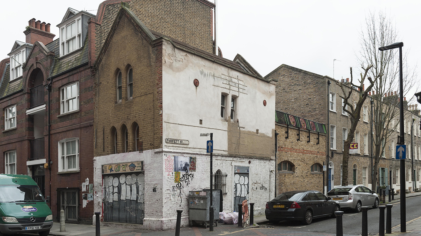
"images": [
{
"id": 296,
"title": "62 Fieldgate Street in 2016",
"author": {
"id": 27,
"username": "DerekKendall"
}
},
{
"id": 297,
"title": "62 Fieldgate Street in 2016 with view down Parfett Street",
"author": {
"id": 27,
"username": "DerekKendall"
}
},
{
"id": 298,
"title": "62 Fieldgate Street, detail of shopfront with figures by Stik on shutter",
"author": {
"id": 27,
"username": "DerekKendall"
}
},
{
"id": 647,
"title": "shopfront detail, 62 Fieldgate Street, April 2017",
"author": {
"id": 27,
"username": "DerekKendall"
}
}
],
"media": []
}
},
{
"id": 1232,
"type": "Feature",
"geometry": {
"type": "MultiPolygon",
"coordinates": [
[
[
[
-0.058822200523125,
51.51902777962813
],
[
-0.058864726926981,
51.51910678355749
],
[
-0.058796596412285,
51.51912310433929
],
[
-0.058751484862884,
51.519044208921414
],
[
-0.058717945552326,
51.51898801961153
],
[
-0.058678541563088,
51.518922004862475
],
[
-0.058608333801111,
51.51887528523524
],
[
-0.058688632677557,
51.518795933274504
],
[
-0.058712070836869,
51.51884364184363
],
[
-0.058712071314352,
51.51884364261143
],
[
-0.058822200523125,
51.51902777962813
]
]
]
]
},
"properties": {
"b_name": "",
"address": "178 Whitechapel Road",
"postcode": "E1 1AA",
"street": "Whitechapel Road",
"categories": [
{
"id": 8,
"name": "Entertainment",
"description": "",
"thumbnail": "https://surveyoflondon.org/media/wiltons_music_hall.png"
},
{
"id": 6,
"name": "Housing",
"description": "",
"thumbnail": "https://surveyoflondon.org/media/SoL-Whitechapel100082.jpg"
},
{
"id": 4,
"name": "Commerce",
"description": "",
"thumbnail": "https://surveyoflondon.org/media/SoL-Whitechapel100156.jpg"
}
],
"count": 2,
"current": 1878,
"site": null,
"feature_type": "WHITECHAPEL_BUILDING",
"documents": [
{
"id": 139,
"title": "Tower Hamlets Arts Project - THAP! - and Despite TV",
"author": {
"id": 45,
"username": "gareth"
}
},
{
"id": 686,
"title": "178 Whitechapel Road",
"author": {
"id": 2,
"username": "surveyoflondon"
}
}
],
"images": [],
"media": []
}
},
{
"id": 934,
"type": "Feature",
"geometry": {
"type": "MultiPolygon",
"coordinates": [
[
[
[
-0.062076973281555,
51.51501335415709
],
[
-0.062030669895335,
51.51480719196857
],
[
-0.062046250091287,
51.51479430240184
],
[
-0.062220057969876,
51.5148013586897
],
[
-0.062222296747502,
51.514875526427346
],
[
-0.062150157140993,
51.51488292381709
],
[
-0.062181898516616,
51.51500342737617
],
[
-0.062076973281555,
51.51501335415709
]
]
]
]
},
"properties": {
"b_name": "",
"address": "147-151 Commercial Road (with 9 New Road)",
"postcode": "E1 1HL",
"street": "Commercial Road",
"categories": [
{
"id": 4,
"name": "Commerce",
"description": "",
"thumbnail": "https://surveyoflondon.org/media/SoL-Whitechapel100156.jpg"
},
{
"id": 10,
"name": "Education",
"description": "",
"thumbnail": "https://surveyoflondon.org/media/SoL-Whitechapel100368-cropped.jpg"
}
],
"count": 0,
"current": 1900,
"site": null,
"feature_type": "WHITECHAPEL_BUILDING",
"documents": [],
"images": [],
"media": []
}
},
{
"id": 1095,
"type": "Feature",
"geometry": {
"type": "MultiPolygon",
"coordinates": [
[
[
[
-0.060296252121652,
51.51593657066081
],
[
-0.06019882709702,
51.515945306274936
],
[
-0.060154697348731,
51.51579016907339
],
[
-0.060253209333859,
51.5157825123297
],
[
-0.06025340133184,
51.515782499071065
],
[
-0.060269064672901,
51.51583361621987
],
[
-0.060269065486975,
51.515833618657744
],
[
-0.060284499984582,
51.51588686449773
],
[
-0.060293739764443,
51.51592817915223
],
[
-0.060296252121652,
51.51593657066081
]
]
]
]
},
"properties": {
"b_name": "",
"address": "Zoar Chapel",
"postcode": "E1 2JP",
"street": "Varden Street",
"categories": [
{
"id": 2,
"name": "Worship",
"description": "",
"thumbnail": "https://surveyoflondon.org/media/DP153535-cropped.jpg"
}
],
"count": 1,
"current": 1922,
"site": null,
"feature_type": "WHITECHAPEL_BUILDING",
"documents": [
{
"id": 1011,
"title": "Zoar Chapel, 27 Varden Street",
"author": {
"id": 2,
"username": "surveyoflondon"
}
}
],
"images": [],
"media": []
}
},
{
"id": 1519,
"type": "Feature",
"geometry": {
"type": "MultiPolygon",
"coordinates": [
[
[
[
-0.055019473204176,
51.52144758023594
],
[
-0.055021856125707,
51.521019563313736
],
[
-0.055141492315973,
51.52101974883205
],
[
-0.055136286973861,
51.52144637002637
],
[
-0.055119644745392,
51.52144789259166
],
[
-0.055019473204176,
51.52144758023594
]
]
]
]
},
"properties": {
"b_name": null,
"address": "Greater Whitechapel",
"postcode": "E1",
"street": null,
"categories": [],
"count": 0,
"current": null,
"site": null,
"feature_type": "GREATER_WHITECHAPEL",
"documents": [],
"images": [],
"media": []
}
},
{
"id": 940,
"type": "Feature",
"geometry": {
"type": "MultiPolygon",
"coordinates": [
[
[
[
-0.063260298350561,
51.51490432967587
],
[
-0.063249863813343,
51.514842085036946
],
[
-0.063308201590578,
51.514843048433995
],
[
-0.063328272385019,
51.51494467498107
],
[
-0.063296584494226,
51.514944927863866
],
[
-0.063293827993989,
51.51490181205867
],
[
-0.063260298350561,
51.51490432967587
]
]
]
]
},
"properties": {
"b_name": "",
"address": "121 Commercial Road",
"postcode": "E1 1NL",
"street": "Commercial Road",
"categories": [
{
"id": 6,
"name": "Housing",
"description": "",
"thumbnail": "https://surveyoflondon.org/media/SoL-Whitechapel100082.jpg"
},
{
"id": 4,
"name": "Commerce",
"description": "",
"thumbnail": "https://surveyoflondon.org/media/SoL-Whitechapel100156.jpg"
}
],
"count": 0,
"current": 1850,
"site": null,
"feature_type": "WHITECHAPEL_BUILDING",
"documents": [],
"images": [],
"media": []
}
},
{
"id": 936,
"type": "Feature",
"geometry": {
"type": "MultiPolygon",
"coordinates": [
[
[
[
-0.062530839107291,
51.51481753003363
],
[
-0.062942060615334,
51.514839988957526
],
[
-0.062982213337414,
51.51499765322008
],
[
-0.062901205800378,
51.51499877922069
],
[
-0.062902100751522,
51.51502384470362
],
[
-0.062526229193034,
51.51501020393487
],
[
-0.062530839107291,
51.51481753003363
]
]
]
]
},
"properties": {
"b_name": "",
"address": "127-139 Commercial Road",
"postcode": "E1 1HL",
"street": "Commercial Road",
"categories": [
{
"id": 8,
"name": "Entertainment",
"description": "",
"thumbnail": "https://surveyoflondon.org/media/wiltons_music_hall.png"
},
{
"id": 1,
"name": "Immigration",
"description": "",
"thumbnail": "https://surveyoflondon.org/media/SoL-Whitechapel100371-cropped.jpg"
},
{
"id": 4,
"name": "Commerce",
"description": "",
"thumbnail": "https://surveyoflondon.org/media/SoL-Whitechapel100156.jpg"
},
{
"id": 6,
"name": "Housing",
"description": "",
"thumbnail": "https://surveyoflondon.org/media/SoL-Whitechapel100082.jpg"
}
],
"count": 1,
"current": 1912,
"site": null,
"feature_type": "WHITECHAPEL_BUILDING",
"documents": [
{
"id": 228,
"title": "Grand Palais Theatre, 1960s",
"author": {
"id": 2,
"username": "surveyoflondon"
}
},
{
"id": 779,
"title": "128 Commercial Road ",
"author": {
"id": 275,
"username": "nb09+-"
}
}
],
"images": [],
"media": []
}
},
{
"id": 568,
"type": "Feature",
"geometry": {
"type": "MultiPolygon",
"coordinates": [
[
[
[
-0.063815761542688,
51.5187571624194
],
[
-0.063899533344591,
51.5188315673863
],
[
-0.063854106097479,
51.5188507914316
],
[
-0.063771382419245,
51.51877567871707
],
[
-0.063815761542688,
51.5187571624194
]
]
]
]
},
"properties": {
"b_name": "",
"address": "6-9 Regal Close",
"postcode": "E1 5NB",
"street": "Whitechapel Road",
"categories": [],
"count": 1,
"current": 1985,
"site": {
"id": 48,
"name": "Davenant Street Development"
},
"feature_type": "WHITECHAPEL_BUILDING",
"documents": [],
"images": [],
"media": []
}
}
]
}
}