HTTP 200 OK
Allow: GET, HEAD, OPTIONS
Content-Type: application/json
Vary: Accept
{
"count": 1712,
"next": "https://surveyoflondon.org/api/v1/features/?format=api&page=23",
"previous": "https://surveyoflondon.org/api/v1/features/?format=api&page=21",
"results": {
"type": "FeatureCollection",
"features": [
{
"id": 1311,
"type": "Feature",
"geometry": {
"type": "MultiPolygon",
"coordinates": [
[
[
[
-0.072212891852196,
51.511015291752464
],
[
-0.072199355177257,
51.511026180515685
],
[
-0.071892753874241,
51.51107377220918
],
[
-0.07185618379654,
51.51098545013041
],
[
-0.071872203924443,
51.51098337431844
],
[
-0.07186219920978,
51.510953969556034
],
[
-0.07184526721746,
51.510955445567966
],
[
-0.071841028671068,
51.51094484938125
],
[
-0.071853037183296,
51.510936859558306
],
[
-0.072212891852196,
51.511015291752464
]
]
]
]
},
"properties": {
"b_name": "Roman Catholic Church of the English Martyrs",
"address": "Roman Catholic Church of the English Martyrs",
"postcode": "E1 8AZ",
"street": "Prescot Street",
"categories": [],
"count": 0,
"current": null,
"site": null,
"feature_type": "WHITECHAPEL_BUILDING",
"documents": [],
"images": [],
"media": []
}
},
{
"id": 477,
"type": "Feature",
"geometry": {
"type": "MultiPolygon",
"coordinates": [
[
[
[
-0.062134737932404,
51.51874869433259
],
[
-0.062238730935859,
51.51893519655255
],
[
-0.062186092786667,
51.5189503233719
],
[
-0.062074527748064,
51.51876109111685
],
[
-0.062134737932404,
51.51874869433259
]
]
]
]
},
"properties": {
"b_name": "",
"address": "213 Whitechapel Road",
"postcode": "E1 1BY",
"street": "Whitechapel Road",
"categories": [
{
"id": 6,
"name": "Housing",
"description": "",
"thumbnail": "https://surveyoflondon.org/media/SoL-Whitechapel100082.jpg"
},
{
"id": 4,
"name": "Commerce",
"description": "",
"thumbnail": "https://surveyoflondon.org/media/SoL-Whitechapel100156.jpg"
}
],
"count": 2,
"current": 1847,
"site": {
"id": 52,
"name": "211–217 Whitechapel Road"
},
"feature_type": "WHITECHAPEL_BUILDING",
"documents": [],
"images": [],
"media": []
}
},
{
"id": 555,
"type": "Feature",
"geometry": {
"type": "MultiPolygon",
"coordinates": [
[
[
[
-0.064489653902719,
51.51900324315394
],
[
-0.064570730009526,
51.51907491569137
],
[
-0.06452639200664,
51.51909373035361
],
[
-0.064444103679026,
51.51902290045871
],
[
-0.064489653902719,
51.51900324315394
]
]
]
]
},
"properties": {
"b_name": "",
"address": "188-192 Old Montague Street",
"postcode": "E1 5NU",
"street": "Old Montague Street",
"categories": [
{
"id": 6,
"name": "Housing",
"description": "",
"thumbnail": "https://surveyoflondon.org/media/SoL-Whitechapel100082.jpg"
}
],
"count": 1,
"current": 1985,
"site": {
"id": 48,
"name": "Davenant Street Development"
},
"feature_type": "WHITECHAPEL_BUILDING",
"documents": [],
"images": [],
"media": []
}
},
{
"id": 1308,
"type": "Feature",
"geometry": {
"type": "MultiPolygon",
"coordinates": [
[
[
[
-0.070520840555992,
51.5110386898154
],
[
-0.070514356388752,
51.51101082694673
],
[
-0.070676647158035,
51.510997044409535
],
[
-0.070688326673746,
51.51103115527454
],
[
-0.070520840555992,
51.5110386898154
]
]
]
]
},
"properties": {
"b_name": "",
"address": "Arch 49 Chamber Street",
"postcode": "E1 8BL",
"street": "Chamber Street",
"categories": [],
"count": 0,
"current": null,
"site": null,
"feature_type": "WHITECHAPEL_BUILDING",
"documents": [],
"images": [],
"media": []
}
},
{
"id": 1229,
"type": "Feature",
"geometry": {
"type": "MultiPolygon",
"coordinates": [
[
[
[
-0.058860343544049,
51.51894097371194
],
[
-0.058860343558978,
51.51894097370836
],
[
-0.058975164006313,
51.51891348503083
],
[
-0.058999857002125,
51.518957100386174
],
[
-0.058889131635543,
51.518984974852245
],
[
-0.058860343544049,
51.51894097371194
]
]
]
]
},
"properties": {
"b_name": "",
"address": "1 East Mount Street",
"postcode": "E1 1AA",
"street": "East Mount Street",
"categories": [],
"count": 2,
"current": null,
"site": {
"id": 33,
"name": "1-2 East Mount Street"
},
"feature_type": "WHITECHAPEL_BUILDING",
"documents": [
{
"id": 142,
"title": "Somali community centre",
"author": {
"id": 44,
"username": "dan"
}
}
],
"images": [
{
"id": 423,
"title": "Plaque on west elevation of 1-2 East Mount Street bearing date and initials, photographed in November 2015",
"author": {
"id": 11,
"username": "amyspencer"
}
}
],
"media": []
}
},
{
"id": 1092,
"type": "Feature",
"geometry": {
"type": "MultiPolygon",
"coordinates": [
[
[
[
-0.060536254004574,
51.51586494607179
],
[
-0.060403340384294,
51.515876517982505
],
[
-0.060393171748183,
51.515823809962036
],
[
-0.060521744125013,
51.5158128892619
],
[
-0.060536254004574,
51.51586494607179
]
]
]
]
},
"properties": {
"b_name": "",
"address": "28 Turner Street",
"postcode": "E1",
"street": "Turner Street",
"categories": [],
"count": 0,
"current": null,
"site": null,
"feature_type": "WHITECHAPEL_BUILDING",
"documents": [],
"images": [],
"media": []
}
},
{
"id": 1089,
"type": "Feature",
"geometry": {
"type": "MultiPolygon",
"coordinates": [
[
[
[
-0.059285067232609,
51.5160288225589
],
[
-0.059176152967528,
51.51604751408793
],
[
-0.059161065243419,
51.516015498679046
],
[
-0.059174259427753,
51.51601307818041
],
[
-0.059120576995721,
51.5158991663988
],
[
-0.059236011815597,
51.51588473193025
],
[
-0.059297668029783,
51.51600019591503
],
[
-0.059273682439476,
51.51600489925327
],
[
-0.059285067232609,
51.5160288225589
]
]
]
]
},
"properties": {
"b_name": "",
"address": "Porchester House",
"postcode": "E1 2NB",
"street": "",
"categories": [],
"count": 0,
"current": null,
"site": null,
"feature_type": "WHITECHAPEL_BUILDING",
"documents": [],
"images": [],
"media": []
}
},
{
"id": 427,
"type": "Feature",
"geometry": {
"type": "MultiPolygon",
"coordinates": [
[
[
[
-0.066564765056846,
51.51748128487466
],
[
-0.066685976317874,
51.51762197421863
],
[
-0.066637945457326,
51.51763763399888
],
[
-0.066570943033159,
51.5175673444226
],
[
-0.066508900140458,
51.51749771486201
],
[
-0.066564765056846,
51.51748128487466
]
]
]
]
},
"properties": {
"b_name": "",
"address": "103 Whitechapel Road",
"postcode": "E1",
"street": "Whitechapel Road",
"categories": [
{
"id": 6,
"name": "Housing",
"description": "",
"thumbnail": "https://surveyoflondon.org/media/SoL-Whitechapel100082.jpg"
},
{
"id": 4,
"name": "Commerce",
"description": "",
"thumbnail": "https://surveyoflondon.org/media/SoL-Whitechapel100156.jpg"
}
],
"count": 2,
"current": 2007,
"site": null,
"feature_type": "WHITECHAPEL_BUILDING",
"documents": [
{
"id": 431,
"title": "103 Whitechapel Road",
"author": {
"id": 2,
"username": "surveyoflondon"
}
}
],
"images": [],
"media": [
{
"id": 83,
"title": "Changing Tastes",
"author": {
"id": 41,
"username": "SusieHay"
}
}
]
}
},
{
"id": 467,
"type": "Feature",
"geometry": {
"type": "MultiPolygon",
"coordinates": [
[
[
[
-0.063156515277658,
51.51874568134991
],
[
-0.0630649796894,
51.518767682046445
],
[
-0.063050592265425,
51.518736777559546
],
[
-0.063137476052168,
51.51871888638596
],
[
-0.063156515277658,
51.51874568134991
]
]
]
]
},
"properties": {
"b_name": "",
"address": "3 Vallance Road",
"postcode": "E1 5NU",
"street": "Vallance Road",
"categories": [
{
"id": 6,
"name": "Housing",
"description": "",
"thumbnail": "https://surveyoflondon.org/media/SoL-Whitechapel100082.jpg"
},
{
"id": 4,
"name": "Commerce",
"description": "",
"thumbnail": "https://surveyoflondon.org/media/SoL-Whitechapel100156.jpg"
}
],
"count": 3,
"current": 1876,
"site": {
"id": 47,
"name": "1-13 Vallance Road"
},
"feature_type": "WHITECHAPEL_BUILDING",
"documents": [
{
"id": 463,
"title": "1-13 Vallance Road",
"author": {
"id": 2,
"username": "surveyoflondon"
}
}
],
"images": [
{
"id": 166,
"title": "3-7 Vallance Road in 2009",
"author": {
"id": 29,
"username": "CRedgrave"
}
},
{
"id": 1824,
"title": "3 Vallance Road in 2009",
"author": {
"id": 29,
"username": "CRedgrave"
}
}
],
"media": []
}
},
{
"id": 1183,
"type": "Feature",
"geometry": {
"type": "MultiPolygon",
"coordinates": [
[
[
[
-0.062192599506635,
51.51791227071151
],
[
-0.062186677054405,
51.517913911668074
],
[
-0.062178164089658,
51.5179142057041
],
[
-0.062170941297499,
51.51791365164895
],
[
-0.062165426441716,
51.51791225640608
],
[
-0.062160238042468,
51.51790973632494
],
[
-0.062156479070994,
51.51790637045424
],
[
-0.062154665974127,
51.517903123678636
],
[
-0.062154941694135,
51.51789991141923
],
[
-0.06215524780367,
51.51789634510788
],
[
-0.062157303441504,
51.517893516814475
],
[
-0.062161602786246,
51.51789071880633
],
[
-0.062166422265738,
51.51788879880243
],
[
-0.062172190708087,
51.51788750306586
],
[
-0.062179431937183,
51.51788762272082
],
[
-0.062185804446109,
51.51788851048918
],
[
-0.06219145117773,
51.517890081792146
],
[
-0.062196624823824,
51.517892949391985
],
[
-0.062200229790092,
51.51789666048044
],
[
-0.062201001721792,
51.51790145498847
],
[
-0.06219982040296,
51.51790630416213
],
[
-0.062196741155671,
51.51790990480113
],
[
-0.062192599506635,
51.51791227071151
]
]
]
]
},
"properties": {
"b_name": "",
"address": "Ambrose King Centre and Grahame Hayton Unit",
"postcode": "E1 2AG",
"street": "Turner Street",
"categories": [],
"count": 0,
"current": null,
"site": null,
"feature_type": "WHITECHAPEL_BUILDING",
"documents": [],
"images": [],
"media": []
}
},
{
"id": 861,
"type": "Feature",
"geometry": {
"type": "MultiPolygon",
"coordinates": [
[
[
[
-0.06458629005838,
51.51780638041829
],
[
-0.064507274353101,
51.51782788345457
],
[
-0.064423389470985,
51.517707899732194
],
[
-0.064505774887929,
51.51768547963217
],
[
-0.06458629005838,
51.51780638041829
]
]
]
]
},
"properties": {
"b_name": "",
"address": "102 Whitechapel Road",
"postcode": "E1 5NB",
"street": "Whitechapel Road",
"categories": [
{
"id": 6,
"name": "Housing",
"description": "",
"thumbnail": "https://surveyoflondon.org/media/SoL-Whitechapel100082.jpg"
},
{
"id": 4,
"name": "Commerce",
"description": "",
"thumbnail": "https://surveyoflondon.org/media/SoL-Whitechapel100156.jpg"
},
{
"id": 5,
"name": "Restaurants",
"description": "",
"thumbnail": "https://surveyoflondon.org/media/SoL_Whitechapel100308.jpg"
}
],
"count": 4,
"current": 1852,
"site": null,
"feature_type": "WHITECHAPEL_BUILDING",
"documents": [
{
"id": 137,
"title": "The Fusco family at 102 Whitechapel Road",
"author": {
"id": 42,
"username": "Nance"
}
},
{
"id": 617,
"title": "102 Whitechapel Road",
"author": {
"id": 2,
"username": "surveyoflondon"
}
}
],
"images": [
{
"id": 1290,
"title": "102 Whitechapel Road, oblique view to east, June 2018",
"author": {
"id": 27,
"username": "DerekKendall"
}
},
{
"id": 1291,
"title": "Al Furqan bookshop, 102 Whitechapel Road, June 2018",
"author": {
"id": 27,
"username": "DerekKendall"
}
}
],
"media": []
}
},
{
"id": 1224,
"type": "Feature",
"geometry": {
"type": "MultiPolygon",
"coordinates": [
[
[
[
-0.057138301528832,
51.51759125212986
],
[
-0.057040267360257,
51.51758962794191
],
[
-0.057040651946729,
51.51758059244742
],
[
-0.0567298391935,
51.51757544249368
],
[
-0.056732147076691,
51.51752122953638
],
[
-0.057035161300039,
51.5175262502802
],
[
-0.05704175841183,
51.51737125679443
],
[
-0.056784419993369,
51.51736699292752
],
[
-0.056779715607069,
51.51747750396161
],
[
-0.056679453660369,
51.51747584255547
],
[
-0.056686821273084,
51.51730277811506
],
[
-0.057015456445764,
51.517308223481855
],
[
-0.057016107286048,
51.517292932644516
],
[
-0.057138649200276,
51.51729496288363
],
[
-0.057128798404023,
51.51752641056975
],
[
-0.057148850820142,
51.51752674278126
],
[
-0.057146129283699,
51.51759068628504
],
[
-0.057138301528832,
51.51759125212986
]
]
]
]
},
"properties": {
"b_name": "",
"address": "54-58 Stepney Way, 82-96 Cavell Street and 61-73 Newark Street",
"postcode": "E1 3BG",
"street": "Newark Street",
"categories": [],
"count": 0,
"current": null,
"site": null,
"feature_type": "WHITECHAPEL_BUILDING",
"documents": [],
"images": [],
"media": []
}
},
{
"id": 864,
"type": "Feature",
"geometry": {
"type": "MultiPolygon",
"coordinates": [
[
[
[
-0.064314324202243,
51.51788892990234
],
[
-0.064192707985004,
51.517929930470984
],
[
-0.064073733170691,
51.51777934541772
],
[
-0.064200709572794,
51.51774105943853
],
[
-0.064314324202243,
51.51788892990234
]
]
]
]
},
"properties": {
"b_name": "",
"address": "108A Whitechapel Road",
"postcode": "E1 5NB",
"street": "Whitechapel Road",
"categories": [
{
"id": 6,
"name": "Housing",
"description": "",
"thumbnail": "https://surveyoflondon.org/media/SoL-Whitechapel100082.jpg"
},
{
"id": 4,
"name": "Commerce",
"description": "",
"thumbnail": "https://surveyoflondon.org/media/SoL-Whitechapel100156.jpg"
},
{
"id": 5,
"name": "Restaurants",
"description": "",
"thumbnail": "https://surveyoflondon.org/media/SoL_Whitechapel100308.jpg"
}
],
"count": 2,
"current": 1924,
"site": null,
"feature_type": "WHITECHAPEL_BUILDING",
"documents": [
{
"id": 620,
"title": "108A Whitechapel Road",
"author": {
"id": 2,
"username": "surveyoflondon"
}
}
],
"images": [
{
"id": 962,
"title": "108-110 Whitechapel Road in March 2017",
"author": {
"id": 27,
"username": "DerekKendall"
}
}
],
"media": []
}
},
{
"id": 1102,
"type": "Feature",
"geometry": {
"type": "MultiPolygon",
"coordinates": [
[
[
[
-0.059764450995764,
51.51561391905557
],
[
-0.059784437649135,
51.515697270101256
],
[
-0.059736691342299,
51.51570216839282
],
[
-0.059728362652395,
51.515670564773956
],
[
-0.059697251924136,
51.51567375641136
],
[
-0.059683666779603,
51.5156222066955
],
[
-0.059764450995764,
51.51561391905557
]
]
]
]
},
"properties": {
"b_name": "",
"address": "30 Varden Street",
"postcode": "E1 2JP",
"street": "Varden Street",
"categories": [],
"count": 0,
"current": null,
"site": null,
"feature_type": "WHITECHAPEL_BUILDING",
"documents": [],
"images": [],
"media": []
}
},
{
"id": 741,
"type": "Feature",
"geometry": {
"type": "MultiPolygon",
"coordinates": [
[
[
[
-0.065378631724211,
51.515916103617165
],
[
-0.06534354857615,
51.51569956237147
],
[
-0.065639021942327,
51.51567120370564
],
[
-0.065694100971794,
51.51589522893205
],
[
-0.065632573888518,
51.51590094290214
],
[
-0.065378631724211,
51.515916103617165
]
]
]
]
},
"properties": {
"b_name": "Swarthmore College",
"address": "Swarthmore College, 73 Greenfield Road",
"postcode": "E1 1EE",
"street": "Greenfield Road",
"categories": [
{
"id": 3,
"name": "Industry",
"description": "",
"thumbnail": "https://surveyoflondon.org/media/DP130783.jpg"
},
{
"id": 10,
"name": "Education",
"description": "",
"thumbnail": "https://surveyoflondon.org/media/SoL-Whitechapel100368-cropped.jpg"
}
],
"count": 0,
"current": 1975,
"site": null,
"feature_type": "WHITECHAPEL_BUILDING",
"documents": [],
"images": [],
"media": []
}
},
{
"id": 1200,
"type": "Feature",
"geometry": {
"type": "MultiPolygon",
"coordinates": [
[
[
[
-0.060118879748966,
51.51652566260798
],
[
-0.060016341165103,
51.51653594723321
],
[
-0.060014516646539,
51.51652961188305
],
[
-0.059993457574508,
51.51653197271118
],
[
-0.059995389508773,
51.51653868105599
],
[
-0.059899819614313,
51.51654939487207
],
[
-0.059884868300982,
51.516497478306
],
[
-0.059857290955835,
51.51650056983554
],
[
-0.059846711023093,
51.51646383219538
],
[
-0.059873376025322,
51.516460842943026
],
[
-0.05986274277915,
51.516423920195145
],
[
-0.059954832250293,
51.51641359655038
],
[
-0.059957253019422,
51.51642200234418
],
[
-0.059991330777799,
51.51641818205435
],
[
-0.059988876417707,
51.516409659642605
],
[
-0.060082450764149,
51.516399169428496
],
[
-0.060118879748966,
51.51652566260798
]
]
]
]
},
"properties": {
"b_name": "James Hora Home, Horace Evans House",
"address": "James Hora Home, Horace Evans House",
"postcode": "E1 2AG",
"street": "Ashfield Street",
"categories": [],
"count": 1,
"current": null,
"site": {
"id": 92,
"name": "Walden Street Nurses' Homes"
},
"feature_type": "WHITECHAPEL_BUILDING",
"documents": [],
"images": [],
"media": []
}
},
{
"id": 297,
"type": "Feature",
"geometry": {
"type": "MultiPolygon",
"coordinates": [
[
[
[
-0.068579013646325,
51.515806570966184
],
[
-0.068603236589372,
51.51579314242831
],
[
-0.068627932264343,
51.51578224735277
],
[
-0.068654968080886,
51.51577953902627
],
[
-0.068682395518699,
51.51578437002237
],
[
-0.068705925916716,
51.51579002894806
],
[
-0.068726713830396,
51.51580349912936
],
[
-0.068739060046585,
51.51582658529491
],
[
-0.068732341766045,
51.51585134703015
],
[
-0.068717700191129,
51.515864899109616
],
[
-0.068579013646325,
51.515806570966184
]
]
]
]
},
"properties": {
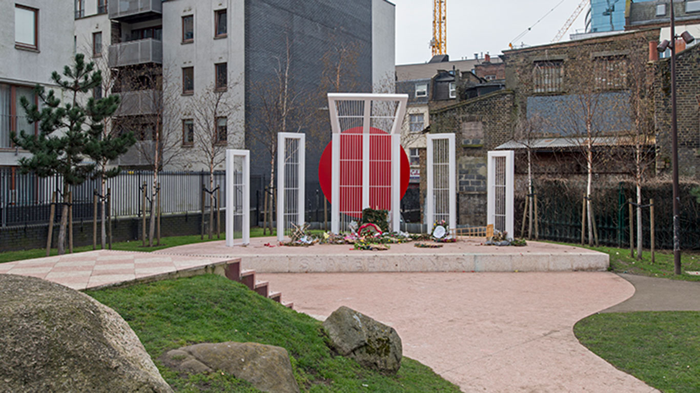
"b_name": "Shaheed Minar",
"address": "Shaheed Minar, Altab Ali Park",
"postcode": "E1 1DQ",
"street": "Whitechapel Road",
"categories": [
{
"id": 1,
"name": "Immigration",
"description": "",
"thumbnail": "https://surveyoflondon.org/media/SoL-Whitechapel100371-cropped.jpg"
},
{
"id": 16,
"name": "Monuments and memorials",
"description": "",
"thumbnail": "https://surveyoflondon.org/media/DP179974-cropped.jpg"
}
],
"count": 5,
"current": 1999,
"site": null,
"feature_type": "WHITECHAPEL_BUILDING",
"documents": [
{
"id": 78,
"title": "Shaheed Minar",
"author": {
"id": 2,
"username": "surveyoflondon"
}
},
{
"id": 564,
"title": "The Shahid Minar and the Bengali Community",
"author": {
"id": 212,
"username": "AnsarAhmedUllah"
}
}
],
"images": [
{
"id": 98,
"title": "Shaheed Minar",
"author": {
"id": 31,
"username": "LucyMW"
}
},
{
"id": 240,
"title": "Altab Ali Park",
"author": {
"id": 36,
"username": "JuditFerencz"
}
},
{
"id": 1039,
"title": "Shahid Minar",
"author": {
"id": 212,
"username": "AnsarAhmedUllah"
}
}
],
"media": []
}
},
{
"id": 1042,
"type": "Feature",
"geometry": {
"type": "MultiPolygon",
"coordinates": [
[
[
[
-0.06715909715278,
51.51350572905074
],
[
-0.067024477179244,
51.51345928597566
],
[
-0.06705826041825,
51.513421001790306
],
[
-0.067194408969612,
51.51346797220098
],
[
-0.06715909715278,
51.51350572905074
]
]
]
]
},
"properties": {
"b_name": "113 Back Church Lane",
"address": "113 Back Church Lane",
"postcode": "E1 1LT",
"street": "Back Church Lane",
"categories": [
{
"id": 6,
"name": "Housing",
"description": "",
"thumbnail": "https://surveyoflondon.org/media/SoL-Whitechapel100082.jpg"
},
{
"id": 11,
"name": "Public Houses",
"description": "",
"thumbnail": "https://surveyoflondon.org/media/SoL-Whitechapel100233.jpg"
}
],
"count": 1,
"current": null,
"site": {
"id": 28,
"name": "109-117 Backchurch Lane"
},
"feature_type": "WHITECHAPEL_BUILDING",
"documents": [],
"images": [],
"media": []
}
},
{
"id": 1045,
"type": "Feature",
"geometry": {
"type": "MultiPolygon",
"coordinates": [
[
[
[
-0.069198443352192,
51.514614678099946
],
[
-0.069392443888346,
51.514482889813806
],
[
-0.069404186565098,
51.51447682151702
],
[
-0.069416943500412,
51.51447331488586
],
[
-0.069428043412608,
51.51447140599199
],
[
-0.069437910284254,
51.51446993562907
],
[
-0.069449992712242,
51.51446928534206
],
[
-0.069465844559872,
51.514470067944934
],
[
-0.069481849987115,
51.51447380906513
],
[
-0.069498287486489,
51.51448051328714
],
[
-0.069508019201712,
51.51448762876296
],
[
-0.069535922138157,
51.51452026968357
],
[
-0.069512776259062,
51.51457350419114
],
[
-0.069270176742894,
51.51467793495888
],
[
-0.069198443352192,
51.514614678099946
]
]
]
]
},
"properties": {
"b_name": "81 Alie Street",
"address": "81 Alie Street",
"postcode": "E1 8NH",
"street": "Alie Street",
"categories": [
{
"id": 4,
"name": "Commerce",
"description": "",
"thumbnail": "https://surveyoflondon.org/media/SoL-Whitechapel100156.jpg"
}
],
"count": 3,
"current": null,
"site": {
"id": 126,
"name": "Altitude Point"
},
"feature_type": "WHITECHAPEL_BUILDING",
"documents": [],
"images": [],
"media": []
}
},
{
"id": 1742,
"type": "Feature",
"geometry": {
"type": "MultiPolygon",
"coordinates": [
[
[
[
-0.076387722492951,
51.516257872286374
],
[
-0.07580974439088,
51.51649846859169
],
[
-0.075744693982384,
51.51651411423466
],
[
-0.075332716624042,
51.51665341173461
],
[
-0.075277819023276,
51.516667372076085
],
[
-0.074429584483841,
51.51681699796736
],
[
-0.074402209988697,
51.516763242480046
],
[
-0.075229889371391,
51.51661092868018
],
[
-0.074836715281391,
51.516135055700595
],
[
-0.074917049606191,
51.51611135328064
],
[
-0.075312012611936,
51.51658616747119
],
[
-0.075695505281233,
51.51646463519818
],
[
-0.075779072585588,
51.51644696856364
],
[
-0.076328753388395,
51.516209038390684
],
[
-0.076387722492951,
51.516257872286374
]
]
]
]
},
"properties": {
"b_name": "",
"address": "Petticoat Lane Market",
"postcode": "E1",
"street": "",
"categories": [
{
"id": 9,
"name": "Markets",
"description": "",
"thumbnail": "https://surveyoflondon.org/media/SoL-Whitechapel100002.jpg"
},
{
"id": 4,
"name": "Commerce",
"description": "",
"thumbnail": "https://surveyoflondon.org/media/SoL-Whitechapel100156.jpg"
},
{
"id": 1,
"name": "Immigration",
"description": "",
"thumbnail": "https://surveyoflondon.org/media/SoL-Whitechapel100371-cropped.jpg"
}
],
"count": 39,
"current": 1760,
"site": null,
"feature_type": "PLACE",
"documents": [
{
"id": 163,
"title": "Petticoat Lane and Tubby Isaacs' jellied eel stall, 1940s",
"author": {
"id": 72,
"username": "eric"
}
},
{
"id": 1151,
"title": "Mark Button of Barneys Seafood remembers Tubby Isaacs and Petticoat Lane market",
"author": {
"id": 2,
"username": "surveyoflondon"
}
},
{
"id": 133,
"title": "Charles Booth on Petticoat Lane",
"author": {
"id": 38,
"username": "laura"
}
},
{
"id": 381,
"title": "Lanterns and Smoked Salmon at Petticoat Lane",
"author": {
"id": 22,
"username": "sarahannmilne"
}
},
{
"id": 411,
"title": "Down the Lane in the early 1960s",
"author": {
"id": 172,
"username": "patricia"
}
},
{
"id": 668,
"title": "Pettitcoat Lane in full song, 1960",
"author": {
"id": 2,
"username": "surveyoflondon"
}
},
{
"id": 1106,
"title": "Petticoat Lane's early history",
"author": {
"id": 2,
"username": "surveyoflondon"
}
},
{
"id": 424,
"title": "Daniel Mendoza, boxer",
"author": {
"id": 178,
"username": "Maureen"
}
},
{
"id": 1108,
"title": "Petticoat Lane Market",
"author": {
"id": 2,
"username": "surveyoflondon"
}
}
],
"images": [
{
"id": 1382,
"title": "Marks of the Lane, 59 Wentworth Street, c. 1960",
"author": {
"id": 252,
"username": "mark3"
}
},
{
"id": 408,
"title": "Wentworth Street",
"author": {
"id": 56,
"username": "tamara"
}
},
{
"id": 1384,
"title": "Marks of the Lane business card",
"author": {
"id": 252,
"username": "mark3"
}
},
{
"id": 410,
"title": "Wentworth Street",
"author": {
"id": 56,
"username": "tamara"
}
},
{
"id": 412,
"title": "Shop on Wentworth Street",
"author": {
"id": 56,
"username": "tamara"
}
},
{
"id": 411,
"title": "Shop on Wentworth Street",
"author": {
"id": 56,
"username": "tamara"
}
},
{
"id": 1386,
"title": "Marks of the Lane - making the Lutkas 1978",
"author": {
"id": 252,
"username": "mark3"
}
},
{
"id": 1387,
"title": "Marks of the Lane on film",
"author": {
"id": 252,
"username": "mark3"
}
},
{
"id": 1389,
"title": "View down Wentworth Street 1976",
"author": {
"id": 252,
"username": "mark3"
}
},
{
"id": 1385,
"title": "Marks of the Lane, 59 Wentworth Street, 1978",
"author": {
"id": 252,
"username": "mark3"
}
},
{
"id": 1375,
"title": "Marks of the Lane Deli",
"author": {
"id": 252,
"username": "mark3"
}
},
{
"id": 416,
"title": "Leyden Street",
"author": {
"id": 56,
"username": "tamara"
}
},
{
"id": 1377,
"title": "Marks of the Lane deli, c. 1974",
"author": {
"id": 252,
"username": "mark3"
}
},
{
"id": 1379,
"title": "The Palkowski warehouse on Old Castle Steet",
"author": {
"id": 252,
"username": "mark3"
}
},
{
"id": 409,
"title": "Goulston Street",
"author": {
"id": 56,
"username": "tamara"
}
},
{
"id": 414,
"title": "Shop on Wentworth Street",
"author": {
"id": 56,
"username": "tamara"
}
},
{
"id": 1380,
"title": "Golda Levy at work in Marks of the Lane deli, 1975",
"author": {
"id": 252,
"username": "mark3"
}
},
{
"id": 1378,
"title": "Mark Palkwoski's chinaware shop, Wentworth St and Old Castle Street",
"author": {
"id": 252,
"username": "mark3"
}
},
{
"id": 1499,
"title": "View west along Wentworth Street",
"author": {
"id": 27,
"username": "DerekKendall"
}
},
{
"id": 413,
"title": "Shop on Wentworth Street",
"author": {
"id": 56,
"username": "tamara"
}
},
{
"id": 1381,
"title": "View towards Marks of the Lane, Wentworth Street",
"author": {
"id": 252,
"username": "mark3"
}
},
{
"id": 1383,
"title": "Marks of the Lane smoke hole letterhead, c1950s",
"author": {
"id": 252,
"username": "mark3"
}
},
{
"id": 1745,
"title": "Market on Wentworth Street in 2017",
"author": {
"id": 27,
"username": "DerekKendall"
}
},
{
"id": 1746,
"title": "market on Wentworth Street in 2017",
"author": {
"id": 27,
"username": "DerekKendall"
}
},
{
"id": 1747,
"title": "Market on Wentworth Street in 2017",
"author": {
"id": 27,
"username": "DerekKendall"
}
},
{
"id": 1748,
"title": "Petticoat Lane Market sign in 2017",
"author": {
"id": 27,
"username": "DerekKendall"
}
},
{
"id": 1749,
"title": "View to the City with Petticoat Lane Market sign in 2017",
"author": {
"id": 27,
"username": "DerekKendall"
}
},
{
"id": 529,
"title": "Memories of A Kid for Two Farthings (1955) being filmed in Whitechapel",
"author": {
"id": 2,
"username": "surveyoflondon"
}
}
],
"media": [
{
"id": 39,
"title": "Petticoat Lane market in February 2014",
"author": {
"id": 25,
"username": "Aileen"
}
},
{
"id": 41,
"title": "The sounds of Petticoat Lane c. 2010",
"author": {
"id": 25,
"username": "Aileen"
}
},
{
"id": 37,
"title": "Petticoat Lane in the 1960s",
"author": {
"id": 25,
"username": "Aileen"
}
},
{
"id": 72,
"title": "Petticoat Lane in 1959",
"author": {
"id": 2,
"username": "surveyoflondon"
}
},
{
"id": 38,
"title": "Petticoat Lane market at the beginning of the 20th century",
"author": {
"id": 25,
"username": "Aileen"
}
},
{
"id": 90,
"title": "Scenes around Petticoat Lane in the 1960s",
"author": {
"id": 2,
"username": "surveyoflondon"
}
}
]
}
}
]
}
}